New Local Plan: Spatial Options Document 2021
Planning for Complete Communities
We recognise that Rochford's urban-rural mix is a key part of its character. Unlike more urbanised areas, Rochford is home to a number of distinct neighbourhoods each of which has its own strengths, challenges, character and sense of community.
Above else, we believe our new Local Plan should support the achievement of a wider vision for the District by understanding and achieving individual visions for our individual communities. We recognise that each community has its own natural, built and cultural heritage that should be understood both individually and as part of the wider District and region.
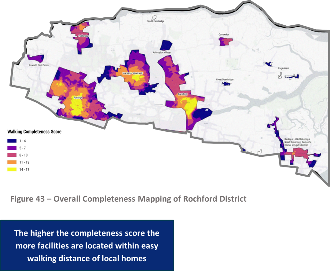
We hope to complement this community vision approach with adopting the core principles of creating complete communities. By complete communities, we mean create places that possess the necessary services for citizens to lead healthy and happy daily lives which are located close-by so that most of the community can access them on foot, cycle or by public transport. The more services a place has, and the easier to access those services are, the more complete that place can be considered to be. We have considered how complete our existing communities are using heatmapping, which is shown at Figure 43.
Whilst it may be possible to make communities more complete through supportive planning policies, it may be in some locations that new development can be tied to new facilities more directly and intelligently than before to make sure the benefits of development genuinely reach those already resident in a community. However, we recognise that some communities, particularly small villages, will never become 'complete'. Whilst residents of these communities are likely to be benefit from having more facilities close at hand, there is not a sufficient population in these places to make service provision viable even with a small amount of new development. It is therefore important to consider our communities as a network and explore how improving the completeness of one community might help serve residents elsewhere.
The complete communities model we are looking at prioritises access to facilities by sustainable means. This means primarily through walking, but also through cycling and using public transport. We recognise that private vehicles are an important part of daily life and that the provision of new and improved roads will be an important part of the plan. Nevertheless, in thinking about how to make our communities more 'complete', we believe that relating the location of services with walkability and public transport nodes can help us achieve wider benefits for communities in terms of their health and wellbeing, reducing pollution within towns and nurturing more active communities.
In each of the following settlement profiles, we consider what the vision for that settlement should be and ways in which the completeness of the settlement could be improved. We also include a diagram displaying the existing level of completeness defined by the percentage of the settlement that has walking access to facilities. The diagram shows walkability to six types of facility: education, health, civic, sport and leisure, green and town centre, with each additional segment illustrating 25% walking coverage up to 4 segments demonstrating 100% of that settlement is within walking distance of at least one facility. See our Complete Communities Topic Paper at <link> for more information.
Lastly, each profile includes a map showing the location of key assets and constraints, alongside land being promoted through the plan, to allow you to consider how the vision for your settlement can be supported by providing new housing, jobs and infrastructure on land in and around the settlement.
Rayleigh
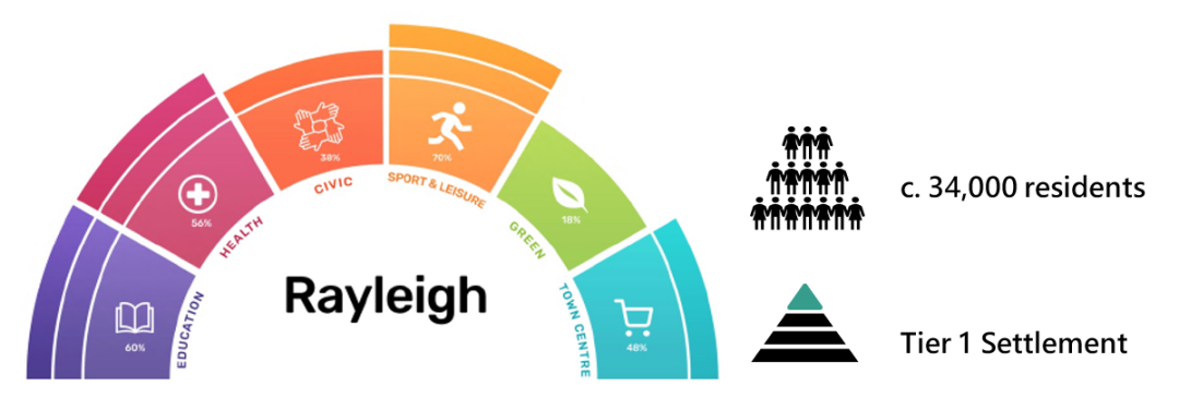
Rayleigh is proposed to be our only Tier 1 settlement reflecting its status as the District's main town, being home to the largest population and providing the greatest number and variety of services. Rayleigh is the principal centre of services for over half the District's residents and businesses, including large communities beyond its own boundaries in Rawreth and Hullbridge parishes. It is the District's largest retail centre and has the largest supply of business premises. Rayleigh has a demographic split that sits roughly at the District average, but has a particularly large commuting population, benefitting from its status as a hub for local rail and bus services, and its easy access to the A127, A1245, A129 and A130.
QUESTIONS
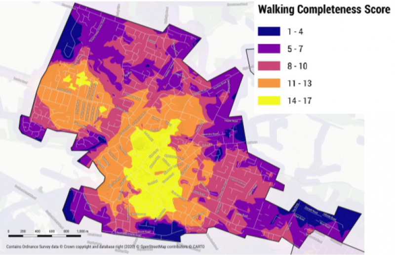
As can be seen from the completeness mapping, Rayleigh benefits from a good standard of walking access to most day-to-day services. The areas of Rayleigh with the best walking access to services are around its town centre, with other strong areas to the west along London Road. Overall, even those parts of Rayleigh outside of the walking catchment of services benefit from good levels of access overall, particularly along the spines of Rawreth Lane, Hockley Road and Eastwood Road. Despite the good range of services provided, the capacity of infrastructure in Rayleigh is known to be a challenge, and opportunities to improve completeness through the plan are likely to be best targeted at improving the capacity and coverage of services, particularly within its suburbs.
Draft Vision statement for Rayleigh
In 2050, Rayleigh should be a thriving town with a wide range of shops and services, vibrant town centre, functional and reliable transport system with all residents living within walking distance of a local green space. It should provide for a diverse range of housing and job opportunities meeting the needs of all in the community, whilst retaining its strong historic and cultural character.
(118) Q56a. Do you agree with our vision for Rayleigh? Is there anything you feel is missing? [Please state reasoning]
(414) Q56b. With reference to Figure 44 and your preferred Strategy Option, do you think any of the promoted sites should be made available for any of the following uses? How could that improve the completeness of Rayleigh?
- Housing [market, affordable, specialist, traveller, other]
- Commercial [offices, industrial, retail, other]
- Community infrastructure [open space, education, healthcare, allotments, other]
- Other
(87) Q56c. Are there areas in Rayleigh that development should generally be presumed appropriate? Why these areas? [Please state reasoning]
(397) Q56d. Are there areas that require protecting from development? Why these areas? [Please state reasoning]
(55) Q56e. Do you agree that the local green spaces shown on Figure 44 hold local significance? Are there any other open spaces that hold particular local significance? [Please state reasoning]
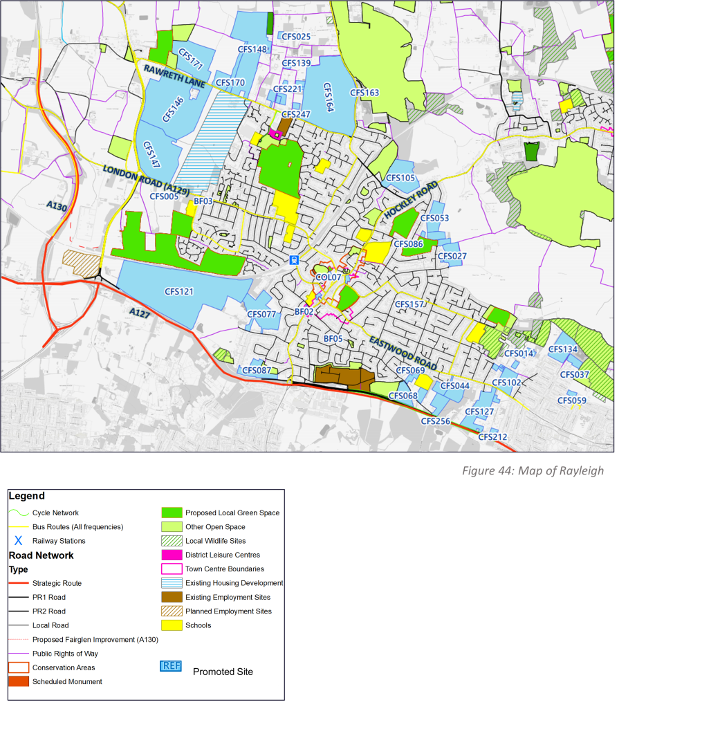
Many of these sites will not be appropriate for development. An initial appraisal of all of these sites is available in the Site Appraisal Paper.
Struggling to view details? You may find it easier to use our interactive consultation map.
Rochford and Ashingdon
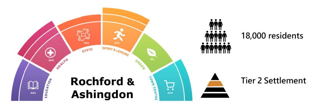
Rochford and Ashingdon together form a functionally-connected settlement home to around 18,000 residents. Between Rochford town centre and a number of neighbourhood centres located throughout the wider settlement, the settlement provides for a reasonably wide range of services and business spaces, including a number of specialist employment areas supporting nearby London Southend Airport. Beyond its immediate boundaries, Rochford and Ashingdon forms a particularly important service base for residents in the villages of Great Stambridge, Canewdon and Paglesham, including for both education and healthcare. Rochford and Ashingdon has a slightly younger population than the District average and has localised areas of deprivation where health outcomes fall below the District average.
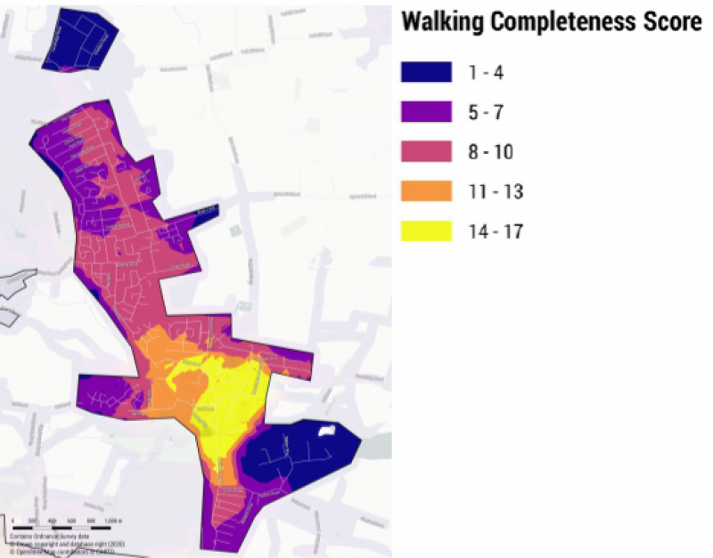
As can be seen from the completeness mapping, residents of Rochford and Ashingdon benefit from good walking access to most services, with the most complete parts of the settlement falling around and to the north of Rochford town centre. Walking access to services remains relatively good along the length of Ashingdon Road but dissipates into the residential area. The only parts of Rochford with particularly poor access to services are around Purdeys industrial estate and the residential neighbourhoods of Ashingdon village. Opportunities to improve completeness include in the provision of leisure services, addressing capacity issues and improving the reliability and frequency of public transport connections to nearby villages.
Vision statement for Rochford and Ashingdon
In 2050, Rochford and Ashingdon should remain the gateway to our rural countryside and grow its service base and sustainable connectivity to ensure all residents within its catchment are provided for and that localised deprivation can be reduced to near zero. Its town centre should be reimagined to become a more sustainable and vibrant space whilst retaining its historic character. It should make the most of its proximity to key employment sites and London Southend Airport to significantly grow its economic potential and the range of jobs it provides for.
(53) Q57a. Do you agree with our vision for Rochford and Ashingdon? Is there anything you feel is missing? [Please state reasoning]
(140) Q57b. With reference to Figure 45 and your preferred Strategy Option, do you think any of the promoted sites should be made available for any of the following uses? How could that improve the completeness of Rochford and Ashingdon?
- Housing [market, affordable, specialist, traveller, other]
- Commercial [offices, industrial, retail, other]
- Community infrastructure [open space, education, healthcare, allotments, other]
- Other
(35) Q57c. Are there areas in Rochford and Ashingdon that development should generally be presumed appropriate? Why these areas? [Please state reasoning]
(108) Q57d. Are there areas that require protecting from development? Why these areas? [Please state reasoning]
(23) Q57e. Do you agree that the local green spaces shown on Figure 45 hold local significance? Are there any other open spaces that hold particular local significance? [Please state reasoning]
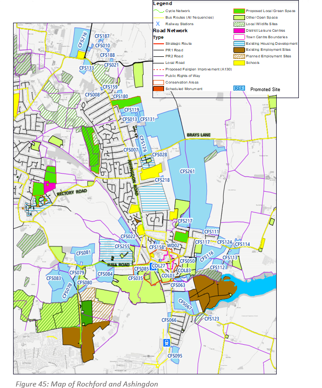
Many of these sites will not be appropriate for development. An initial appraisal of all of these sites is available in the Site Appraisal Paper. Struggling to view details? You may find it easier to use our Interactive Consultation Map.
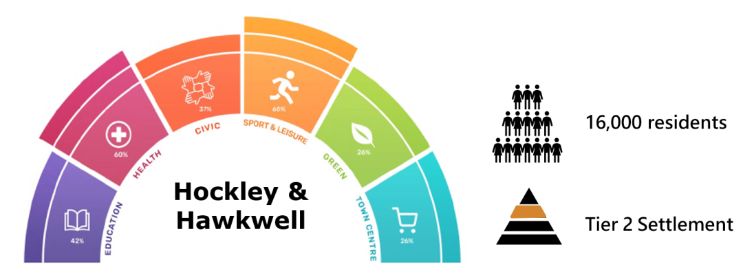
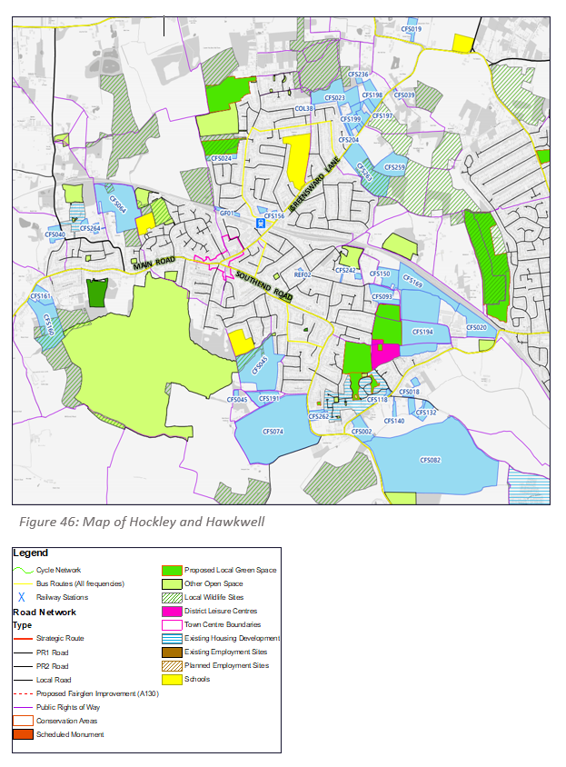
Hockley and Hawkwell
Hockley and Hawkwell are two distinct places that form a functionally connected settlement in the heart of the District. Home to around 16,000 people, the settlement provides for a reasonable range of services that serve both its own residents and a small number of villages beyond its boundary. These services include a small but busy town centre, a range of community facilities and a significant hectarage of natural space, including the largest remaining area of wildwood in the country, Hockley Woods. Hockley and Hawkwell are amongst the least deprived neighbourhoods in the entire District with housing availability and affordability a key issue in this part of the District. They are home to a slightly older population than the local average, but their overall demographic profile is similar to the District as a whole.
As can be seen from the completeness mapping, Hockley and Hawkwell residents benefit from generally good walking access to most day-to-day services, with the best levels of access around the town centre and along Southend Road. The completeness of Hockley and Hawkwell does notably drop off along its periphery, however these areas are relatively less densely populated. Opportunities to improve completeness include improving the range of services provided within the settlement, addressing capacity issues and improving public transport connectivity to rural villages in its catchment.
Vision statement for Hockley and Hawkwell
In 2050, Hockley and Hawkwell should be the District's gateway to the green lung of the Upper Roach Valley, making the most of its access to ancient woodland and a network of nature reserves. Its town and neighbourhood centres should be vibrant places with an emphasis on independent businesses and providing for a diverse range of jobs. Deprivation should continue to be largely absent from Hockley and Hawkwell however housing affordability should have been addressed to ensure that local first-time buyers can greater afford to live locally.

(638)
Q58b. With reference to Figure 46 and your preferred Strategy Option, do you think any of the promoted sites should be made available for any of the following uses? How could that improve the completeness of Hockley and Hawkwell?
i. Housing [market, affordable, specialist, traveller, other]
ii. Commercial [offices, industrial, retail, other]
iii. Community infrastructure [open space, education, healthcare, allotments, other]
iv. Other
Many of these sites will not be appropriate for development. An initial appraisal of all of these sites is available in the Site Appraisal Paper. Struggling to view details? You may find it easier to use our Interactive Consultation Map.
The Wakerings and Barling
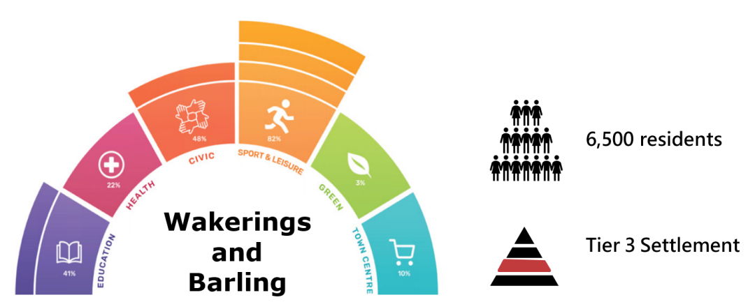
The Wakerings and Barling consist of a cluster of villages in the far eastern extent of the District. The villages stretch out along two main roads, Little Wakering Road and High Street, with a cluster of shops, a primary school and a medical centre concentrated on Great Wakering high street. Outside its centre, the settlement is largely rural in nature and benefits from its tranquil setting near the coast with the North Sea. Whilst the settlement has a good range of core facilities, these only serve local residents and most town-scale facilities, such as a secondary school and large-scale job opportunities, are absent. For this reason, the Wakerings and Barling are heavily reliant on nearby Shoeburyness and Rochford town for some day-to-day services. The population of the Wakerings and Barling skews slightly younger than the District average which may generate additional demand for housing and jobs in coming years.
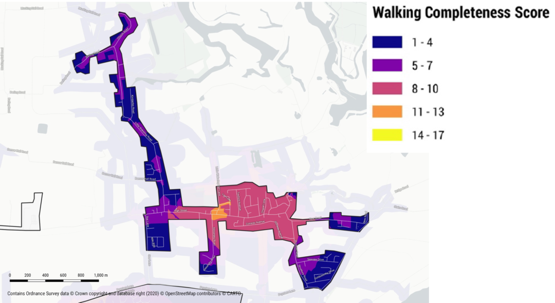
As can be seen from the completeness mapping, the majority of Great Wakering has reasonable walking access to day-to-day services. However, walking access dissipates rapidly towards the edges of the wider settlement, particularly within Little Wakering and Barling. Opportunities to address completeness in this settlement are both in improving the range of facilities available, including making secondary school provision more accessible, and improving sustainable connectivity to nearby towns.
Draft Vision statement for the Wakerings and Barling
In 2050, the Wakerings and Barling should have retained their rural village character and sense of relative tranquillity. More services should have developed locally to reduce its reliance on neighbouring towns, whilst any new services introduced should be located so that those located on the edges of the settlement are able to access them sustainably. The villages should have become more self-sufficient when it comes to homes, jobs and community facilities, including education. Development that takes place should be locally-responsive and aimed at meeting the ongoing housing and employment needs of local residents.
(80)
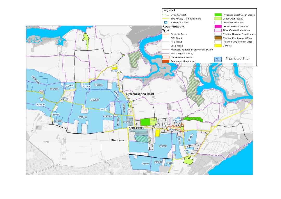
Q59b. With reference to Figure 47 and your preferred Strategy Option, do you think any of the promoted sites should be made available for any of the following uses? How could that improve the completeness of the Wakerings and Barling?
i. Housing [market, affordable, specialist, traveller, other]
ii. Commercial [offices, industrial, retail, other]
iii. Community infrastructure [open space, education, healthcare, allotments, other]
iv. Other
(30) Q59c. Are there areas in the Wakerings and Barling that development should generally be presumed appropriate? Why these areas? [Please state reasoning]
(61) Q59d. Are there areas that require protecting from development? Why these areas? [Please state reasoning]
(16) Q59e. Do you agree that the local green spaces shown on Figure 47 hold local significance? Are there any other open spaces that hold particular local significance? [Please state reasoning]
Many of these sites will not be appropriate for development. An initial appraisal of all of these sites is available in the Site Appraisal Paper. Struggling to view details? You may find it easier to use our Interactive Consultation Map.
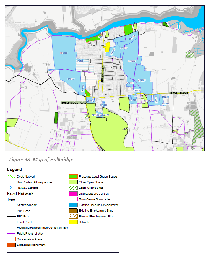
Hullbridge
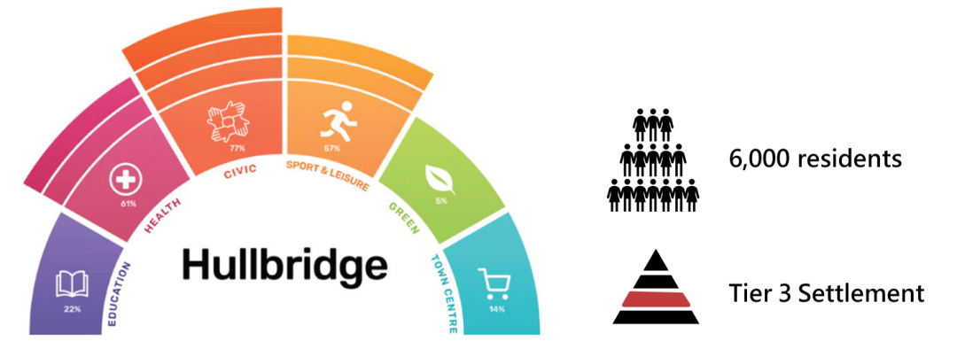
Hullbridge is a large village of around 6,000 residents located to the north-west of the District. It sits upon the course of the River Crouch and is home to a range of river-based enterprises and activities. The village provides for a range of basic services, including multiple shops, a primary school and medical centre. It has a relatively tight catchment but provides a base of services for local residents and some outlying villages, including Battlesbridge, and a number of rural caravan parks. Hullbridge is itself reliant on towns such as Rayleigh and Hockley for some services, including secondary schools and leisure. Hullbridge has a larger older population than the District average that is anticipated to continue to grow over coming years which may place demand on particular types of service close at hand.
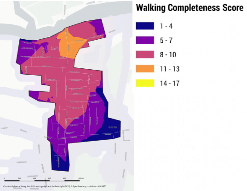
The completeness mapping shows Hullbridge residents to have reasonably good walking access to most services, particularly to its north where a cluster of services lie, including a healthcare centre and primary school. Walking access remains relatively good along most of the central spine formed by Ferry Road but notably dissipates into residential areas and along its southern edge. Opportunities to improve completeness are improving the range and capacity of local services, including providing for more job opportunities locally.
Vision statement for Hullbridge
In 2050, Hullbridge should have grown its service base to become relatively more self-sufficient and accessible by sustainable means, including walking, cycling, river-based and public transport. It should have made the most of its location including opening up its coastline as a more attractive and usable space for both residents and visitors. Any development that takes place should be locally-responsive and aimed at meeting the ongoing housing and employment needs of local residents, including the housing needs of the local older population.
(59) Q60a. Do you agree with our vision for Hullbridge? Is there anything you feel is missing? [Please state reasoning]
(85) Q60b. With reference to Figure 48 and your preferred Strategy Option, do you think any of the promoted sites should be made available for any of the following uses? How could that improve the completeness of Hullbridge?
- Housing [market, affordable, specialist, traveller, other]
- Commercial [offices, industrial, retail, other]
- Community infrastructure [open space, education, healthcare, allotments, other]
- Other
(32) Q60c. Are there areas in Hullbridge that development should generally be presumed appropriate? Why these areas? [Please state reasoning]
(68) Q60d. Are there areas that require protecting from development? Why these areas? [Please state reasoning]
(26) Q60e. Do you agree that the local green spaces shown on Figure 48 hold local significance? Are there any other open spaces that hold particular local significance? [Please state reasoning]
Many of these sites will not be appropriate for development. An initial appraisal of all of these sites is available in the Site Appraisal Paper. Struggling to view details? You may find it easier to use our Interactive Consultation Map.
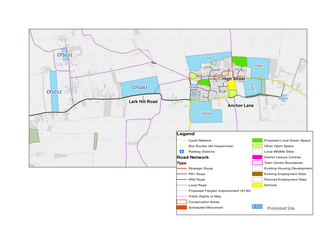
Canewdon
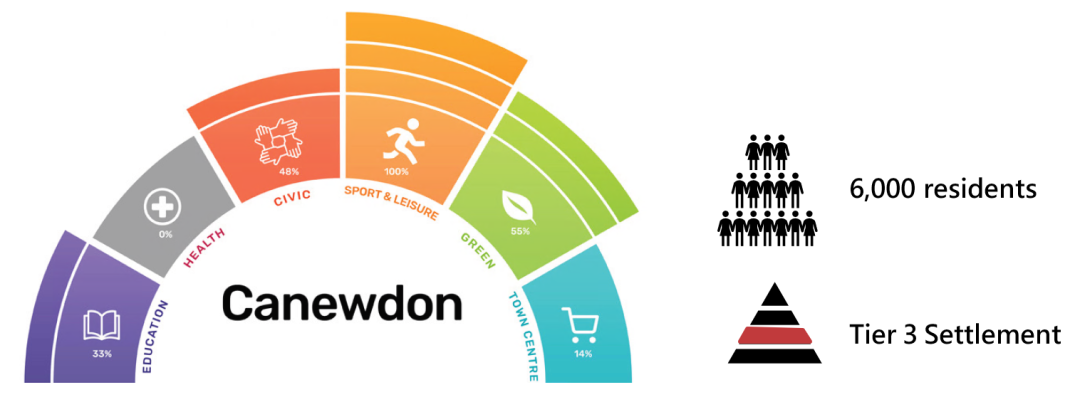
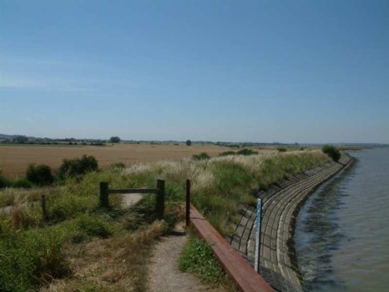
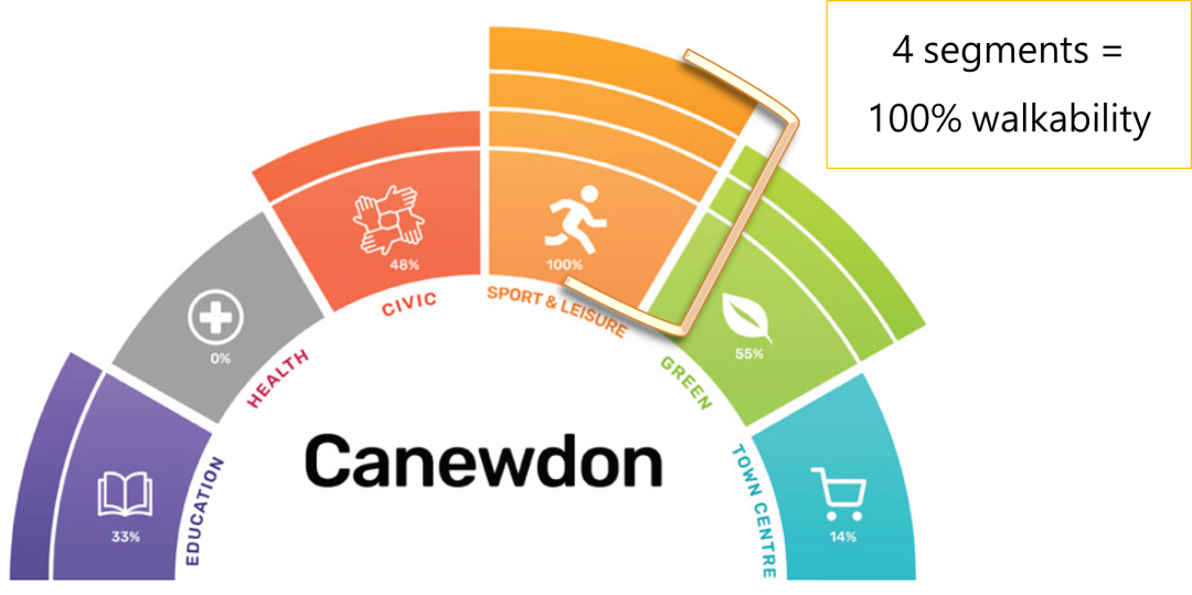
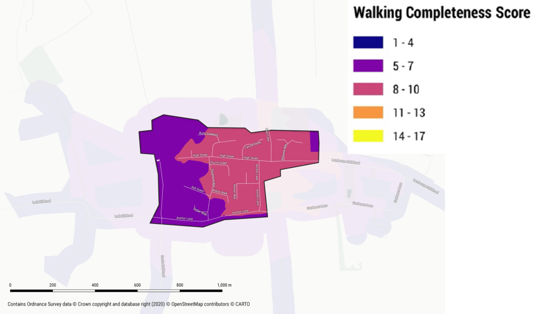
Canewdon is a relatively isolated village located in the rural north-east of the District. It is a relatively compact and self-sustaining village with reasonably good service provision for a population of its size, including a village shop and primary school clustered around its high street. These services primary serve residents of the village, but also provide for rural residents in surrounding hamlets. Whilst its remoteness is one of its characterising strengths, it does also pose challenges in terms of generally poor connectivity both in terms of transport and digital services. Its demographic split largely reflects the District averages.
The walking completeness of Canewdon is reasonably good with the few services within the village being within reasonable walking distance of most of the village's residents. However, the village is relatively reliant on nearby towns, including Rochford, for a good number of day-to-day services, including healthcare, secondary education and employment. Opportunities to improve completeness include improving the range of services available locally, restoring lost services, particularly healthcare services, and improving sustainable connectivity to nearby towns, including Rochford, such as through a more regular bus service.
Draft Vision statement for Canewdon
In 2050, Canewdon should have retained its character as a relatively compact and self-sustaining village. It should have retained its existing services, including its primary school, and its residents' access to other services, including healthcare and jobs, should have been improved through a combination of improved transport connectivity and service provision. Development that has taken place in Canewdon should have been locally-responsive to meet the ongoing needs of local residents, including first-time buyers.
(15)
Q61b. With reference to Figure 49 and your preferred Strategy Option, do you think any of the promoted sites should be made available for any of the following uses? How could that improve the completeness of Canewdon?
i. Housing [market, affordable, specialist, traveller, other]
ii. Commercial [offices, industrial, retail, other]
iii. Community infrastructure [open space, education, healthcare, allotments, other]
iv. Other
Many of these sites will not be appropriate for development. An initial appraisal of all of these sites is available in the Site Appraisal Paper. Struggling to view details? You may find it easier to use our Interactive Consultation Map.
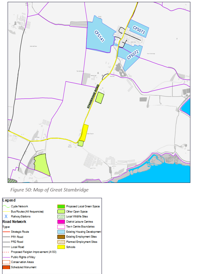
Great Stambridge
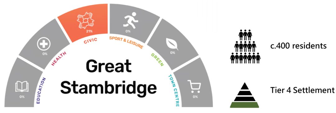
Great Stambridge is a relatively small village located to the east of Rochford town. It is home to around 400 residents, although its identifying population is significantly more when including rural populations and residents living on the eastern edge of Rochford town. The village possesses a good number of facilities for a settlement of its size, including a primary school, church and village hall, however the layout of the village means that these facilities are outside of the walking catchment of most of the village's residents. Due to its location, less than a mile from the eastern edge of Rochford town, the residents of the village benefit from a combination of relative tranquillity created by their detachment from the main urban area and easy access to all the services located in the town, including its job opportunities, retail outlets and railway station.
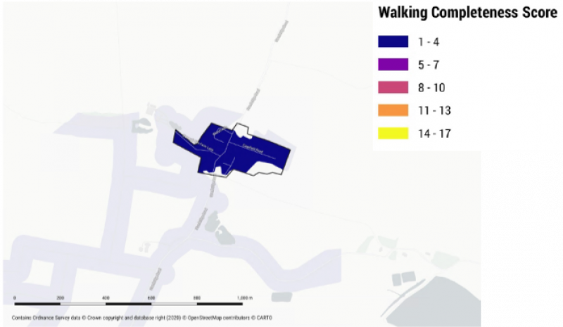
As can be seen from the completeness mapping, the centre of population in Great Stambridge is relatively detached from the services along Stambridge Road and walking to these services is likely to be a relatively unattractive proposition to many residents. Opportunities to improve the completeness of Great Stambridge are less likely to be focussed on the provision of new services but on the enhancement of existing services, both in the village and in Rochford town, and improving their accessibility through sustainable means.
Draft Vision statement for Great Stambridge
In 2050, Great Stambridge should remain an independent village with its own character and sense of community. It should benefit from improved accessibility between its homes and services and its residents should be able to access the wider services in Rochford town with less dependence on the private car. Any development that takes place should be strictly in keeping with the character of the village and be of a form and type that responds to the individual needs of the village.
(37) Q62a. Do you agree with our vision for Great Stambridge? Is there anything you feel is missing? [Please state reasoning]
(31) Q62b. With reference to Figure 50 and your preferred Strategy Option, do you think any of the promoted sites should be made available for any of the following uses? How could that improve the completeness of Great Stambridge?
- Housing [market, affordable, specialist, traveller, other]
- Commercial [offices, industrial, retail, other]
- Community infrastructure [open space, education, healthcare, allotments, other]
- Other
(18) Q62c. Are there areas in Great Stambridge that development should generally be presumed appropriate? Why these areas? [Please state reasoning]
(21) Q62d. Are there areas that require protecting from development? Why these areas? [Please state reasoning]
(17) Q62e. Do you agree that the local green spaces shown on Figure 50 hold local significance? Are there any other open spaces that hold particular local significance? [Please state reasoning]
Many of these sites will not be appropriate for development. An initial appraisal of all of these sites is available in the Site Appraisal Paper. Struggling to view details? You may find it easier to use our Interactive Consultation Map.
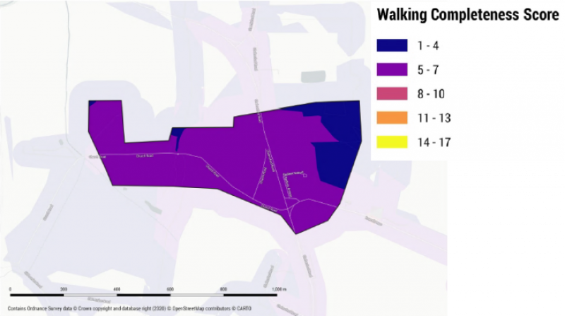
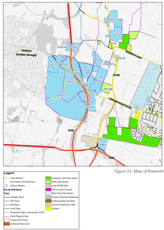
Rawreth
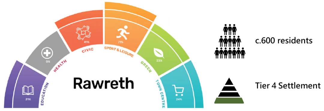
Rawreth is a village located to the west of the District, home to approximately 600 residents. It is located approximately halfway between the larger towns of Rayleigh and Wickford (located in Basildon Borough). Rawreth has a relatively good supply of services for a village of its population, including open space, a nursery and village hall, whilst it has reasonably good access to services in those towns. The village is well-located for accessing the strategic road network, with the main village envelope being located between the routes of the A130 and A1245, with nearby access to the A129 and A127. However, sustainable transport provision is relatively more limited, with residents of the village much more reliant on nearby towns for train and bus services.
Rawreth has a reasonable degree of completeness for its population however there may be opportunities to improve connectivity to nearby towns through sustainable methods, such as more regular bus services and new cycling and walking routes. A significant amount of land is being promoted near Rawreth, both adjacent to and beyond the existing village. An area to the south of the village is also identified as being a strategic growth option earlier in this paper. Whilst it is unlikely that this growth area, if taken forward, would adjoin Rawreth village itself, it may be able to help to improve the completeness of the village by providing new services nearby, including retail services, job opportunities and new public transport connections.
Draft Vision statement for Rawreth
In 2050, Rawreth should remain a functionally separate village with its own identity and sense of community. It should have retained and enhanced its core services and its resident should benefit from improved access to these by public and sustainable transport. Any development that takes place in the village, or nearby, should ensure it takes opportunities to improve the access of the village's residents to wider services, including to address relatively poor sustainable access to health, education and public transport services.
(14) Q63a. Do you agree with our vision for Rawreth? Is there anything you feel is missing? [Please state reasoning]
(15) Q63b. With reference to Figure 51 and your preferred Strategy Option, do you think any of the promoted sites should be made available for any of the following uses? How could that improve the completeness of Rawreth?
- Housing [market, affordable, specialist, traveller, other]
- Commercial [offices, industrial, retail, other]
- Community infrastructure [open space, education, healthcare, allotments, other]
- Other
(12) Q63c. Are there areas in Rawreth that development should generally be presumed appropriate? Why these areas? [Please state reasoning]
(11) Q63d. Are there areas that require protecting from development? Why these areas? [Please state reasoning]
(5) Q63e. Do you agree that the local green spaces shown on Figure 51 hold local significance? Are there any other open spaces that hold particular local significance? [Please state reasoning]
Many of these sites will not be appropriate for development. An initial appraisal of all of these sites is available in the Site Appraisal Paper. Struggling to view details? You may find it easier to use our Interactive Consultation Map.
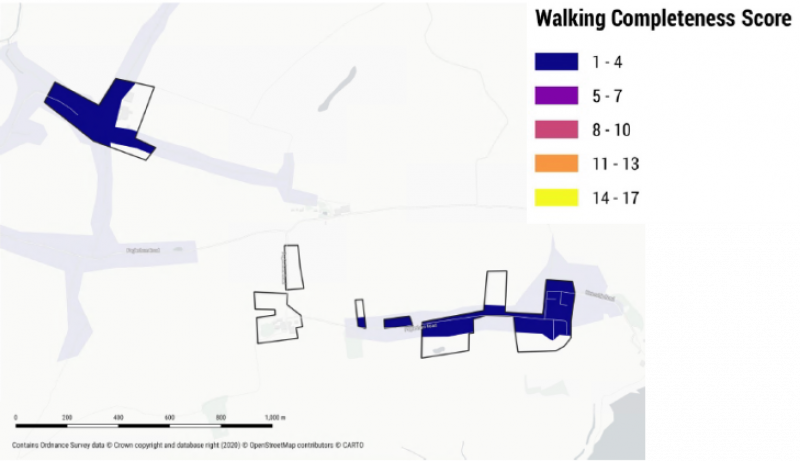
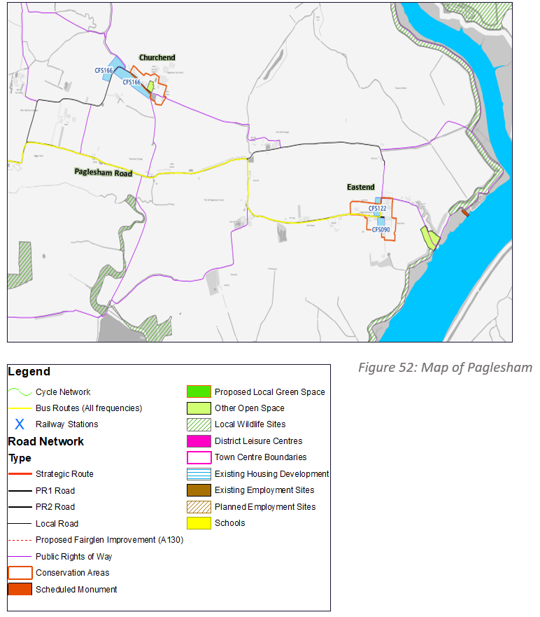
Paglesham
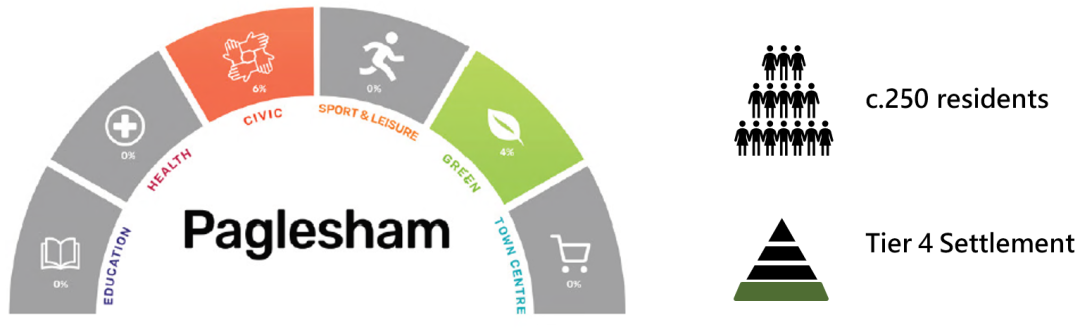
Paglesham is a cluster of hamlets located in the eastern extent of the District. Home to a combined 250 residents, Paglesham Churchend and Eastend are historic settlements, both covered by a conservation area. They are relatively remote from any of our key service towns and villages and do not benefit from any services but save for a public house and a small area of open space. Paglesham also benefits from its close access to picturesque areas of the coast.
As can seen from the completeness mapping, Paglesham has relatively poor walking access to most day-to-day services, both due to the absence of those facilities and the distribution of homes being relatively dispersed over a wide area. Due to its low population, it is relatively unlikely that its completeness could be improved without a significant amount of new development, which itself is unlikely to be appropriate given its relatively remote location and large areas at risk of flooding. Nevertheless, there may be opportunities through the plan to improve the completeness of Paglesham through rural service models and improved sustainable access to nearby villages and towns, such as a more frequent bus service.
Draft Vision statement for Paglesham
In 2050, Paglesham should remain a tranquil and rural cluster of hamlets with the historic areas of Churchend and Eastend having been immaculately conserved. It should have retained its core services, including its public house and open space, whilst its resident should benefit from improved sustainable access to the services in nearby towns and villages. It should also have become a focal point for managed public access to the rural coast. Any development that takes place should be very small scale and in-keeping with the historic, rural character of the hamlets.
(8) Q64a. Do you agree with our vision for Paglesham? Is there anything you feel is missing? [Please state reasoning]
(6) Q64b. With reference to Figure 52 and your preferred Strategy Option, do you think any of the promoted sites should be made available for any of the following uses? How could that improve the completeness of Paglesham?
- Housing [market, affordable, specialist, traveller, other]
- Commercial [offices, industrial, retail, other]
- Community infrastructure [open space, education, healthcare, allotments, other]
- Other
(4) Q64c. Are there areas in Paglesham that development should generally be presumed appropriate? Why these areas? [Please state reasoning]
(5) Q64d. Are there areas that require protecting from development? Why these areas? [Please state reasoning]
(4) Q64e. Do you agree that the local green spaces shown on Figure 52 hold local significance? Are there any other open spaces that hold particular local significance? [Please state reasoning]
Many of these sites will not be appropriate for development. An initial appraisal of all of these sites is available in the Site Appraisal Paper. Struggling to view details? You may find it easier to use our Interactive Consultation Map.
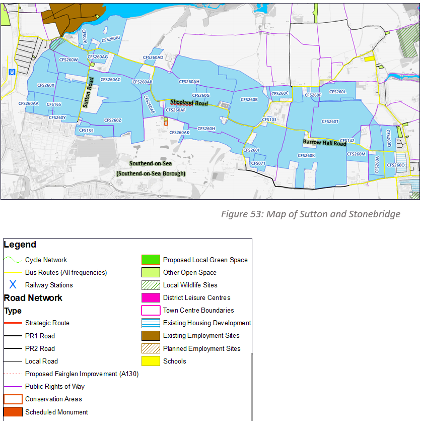
Stonebridge
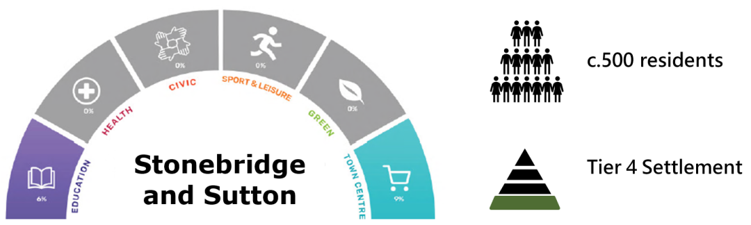
Stonebridge and Sutton are some of a number of sparsely populated hamlets located within a large and relatively open tranche of land to the east of Rochford town and north of the Southend urban area. There are very few services provided in this area and a majority of the land in this area is given over to agriculture. The largest area of continuous settlement in the area is Stonebridge, which extends over the administrative boundary into Southend Borough.
Due to the absence of any services, Stonebridge and Sutton has a very low level of completeness, with the only parts of the area with any walking access to services being those parts of Stonebridge nearest to the urban area of Southend. There is a significant amount of land being promoted in the area of Stonebridge and Sutton, both adjacent to existing areas of settlement and into the open countryside. This land is identified as a strategic growth option earlier in this report. Whilst it is recognised that the vast majority of the land being promoted in this area is not adjacent to existing communities, the development of areas of this land would provide opportunities to improve the completeness of existing communities in Stonebridge and Sutton by creating new services, including education, healthcare, retail and jobs, and providing an opportunity to improve sustainable connectivity.
Draft Vision statement for Stonebridge and Sutton
In 2050, Stonebridge and Sutton should still be recognisable places of their own right, however residents of these places should have greater access to services close at hand, including by sustainable means. Any development that takes place in the areas around Stonebridge and Sutton should respect and take inspiration from the individual rural and low-density character of these settlements.
(20) Q65a. Do you agree with our vision for Sutton and Stonebridge? Is there anything you feel is missing? [Please state reasoning]
(23) Q65b. With reference to Figure 53 and your preferred Strategy Option, do you think any of the promoted sites should be made available for any of the following uses? How could that improve the completeness of Sutton and Stonebridge?
- Housing [market, affordable, specialist, traveller, other]
- Commercial [offices, industrial, retail, other]
- Community infrastructure [open space, education, healthcare, allotments, other]
- Other
(7) Q65c. Are there areas in Sutton and Stonebridge that development should generally be presumed appropriate? Why these areas? [Please state reasoning]
(15) Q65d. Are there areas that require protecting from development? Why these areas? [Please state reasoning]
(7) Q65e. Do you agree that the local green spaces shown on Figure 53 hold local significance? Are there any other open spaces that hold particular local significance? [Please state reasoning]
Many of these sites will not be appropriate for development. An initial appraisal of all of these sites is available in the Site Appraisal Paper. Struggling to view details? You may find it easier to use our Interactive Consultation Map.
Rural Communities
As recognised elsewhere in this document, Rochford has a unique mix of urban and rural environments which is reflected in the fact that over 5,000 of our residents live outside of the settlements identified earlier in this section.
These residents mostly live in rural housing beyond the boundary of recognised settlements. This includes small pockets of concentrated housing, including in plotland areas between our main towns, and more isolated housing spread out along inter-urban roads. More concentrated areas of population exist at Battlesbridge, South Fambridge, and Foulness Churchend. As these settlements have very modest populations, a general absence of services and do not have land being promoted nearby, it is generally considered unlikely that opportunities for significant change exist in these settlements. The more populated areas of Battlesbridge, in particular, fall within the administrative area of Chelmsford City.
As a result, we have chosen not to prepare individual vision statements for these settlements at this time. Nevertheless, we think it is important to consider a vision for all of our rural communities which can help to guide decisions through the plan that can benefit those not living within a recognised Tier 1-4 settlement.
Our vision statement for Rural Communities is set out below:
Draft Vision statement for Rural Communities
In 2050, our rural communities should have remained rural and the contribution these communities make to the character of the District should be safeguarded. The service needs of our rural communities should have been supported by an improved network of sustainable transport linkages, including in the development of new public transport, walking, cycling and equestrian routes. The needs of these communities should also have been taken into account when decisions are made about the provision of services in major towns and villages which rural communities are likely to depend on.