New Local Plan: Spatial Options Document 2021
You can select different parts of the document above and leave comments everywhere you see a Question. Questions are indicated by a pink box next to a speech bubble. Please note you must create an account and log in to leave comments.
Introduction
What is the Spatial Options document?
The Spatial Options document is a consultation paper that forms the latest stage in the production of Rochford District Council's new Local Plan. Once adopted, the new Local Plan will set a new planning strategy for the District to 2040, helping to co-ordinate the delivery of much needed housing, employment and infrastructure, whilst ensuring that our natural, historic and built environments are protected and enhanced for future generations to enjoy.
The Spatial Options document sets out a range of challenges and opportunities relating to how Rochford District can change and grow over the next 20 years. These challenges and opportunities relate to a number of important, interconnected themes that together will contribute to achieving a sustainable vision for the District. This consultation is an important step in exploring the advantages and disadvantages of different strategy options, alongside the contribution these options can make to fulfilling the objectives of the District and its diverse settlements.
This consultation builds on past consultations (set out later in this section), however it is not intended to revisit many of the issues explored in past consultations. The Spatial Options document will be exploring a more specific set of challenges and opportunities relating to key spatial issues (those relating to the use of specific areas of land and buildings). It will also provide an opportunity for us to consider specific issues that may have emerged since past consultations, either because they have been identified by new evidence, or a new requirement has been introduced by national policy.
It is important to recognise that the Spatial Options document is only a consultation paper and is not recommending a particular course of action. Instead the document presents a range of different options that feedback is sought on. Options presented within this document are unlikely to be equally sustainable and further work, and consultation, will be required on the new Local Plan to ensure the options that are ultimately selected are the right ones for Rochford and its communities.


How have we got here?
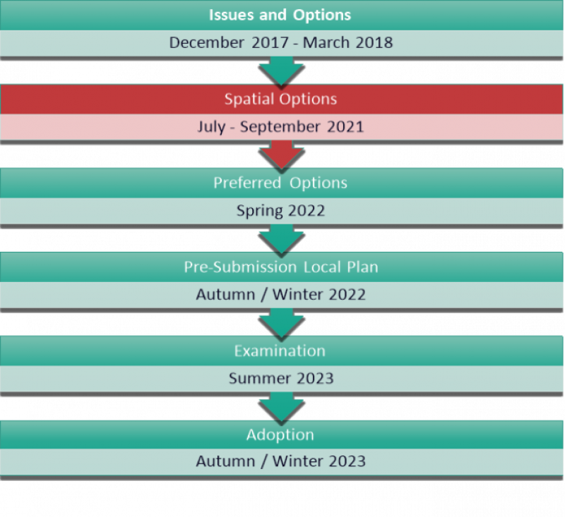
This document is the second of an expected four stages in preparing the new Local Plan.
The Council has been working on its new Local Plan since 2015. Once adopted, it will replace the current suite of documents that make up our local development plan. These include the Core Strategy (adopted in 2011), the Development Management Plan (adopted in 2014), the Allocations Plan (adopted in 2014) and our four Area Action Plans (adopted in 2014 and 2015).
In 2016, the Council undertook a programme of local community engagement which was co-ordinated with local parish and town councils. This engagement provided useful local insight into the challenges and opportunities that exist within our towns and villages, alongside feedback on how current plans are or are not working for communities at a local level. The outcomes of this engagement programme can be viewed here.
In late 2017/early 2018, the Council formally consulted on the first stage of its new Local Plan: the Issues and Options document. This document set out a comprehensive range of issues and options relating to the future of the District, and how the planning system could help deliver new opportunities. A range of issues were raised through the consultation which have influenced the direction of the new Local Plan since, and which will continue to be explored, alongside further consultation feedback, through the plan-making process. A feedback report was published on the Council's website and can be viewed here, with a short summary of relevant feedback included in this and each of the thematic chapters within this document.
What is a Local Plan, in simple terms?
Each District Council in the country must prepare a document for their area called a 'Local Plan'. The Local Plan sets policies, or rules, that state what different pieces of land can be used for (or what can be built on them).
Local Plans must meet certain rules to be approved. This includes needing to follow rules set by Government, needing to be justified by evidence and needing to provide for enough new development to meet local needs (including for housing).
This will not the last opportunity you have to influence the new Local Plan, with two further stages of consultation planned. However, it is important to make your views known on the plan at the earliest opportunity. Once the Council feels the Local Plan is ready, it will submit it for examination by a Government Inspector, which, if successful, will allow it to be adopted. It is recognised that the Government is currently proposing substantial changes to the planning system, including to the role of Local Plans and the way they must be prepared. Should these be changes be introduced, the timetable shown alongside this text may need to be revised.
What is a Local Plan, in simple terms?
Each District Council in the country must prepare a document for their area called a ‘Local Plan’. The Local Plan sets policies, or rules, that state what different pieces of land can be used for (or what can be built on them).
Local Plans must meet certain rules to be approved. This includes needing to follow rules set by Government, needing to be justified by evidence and needing to provide for enough new development to meet local needs (including for housing).
What did you tell us when last consulted?
Between December 2017 and March 2018, we consulted on our New Local Plan: Issues and Options document.
The Issues and Options Document (and accompanying Sustainability Appraisal) set
out the key challenges and opportunities that had been identified in relation to the future
evolution, prosperity and vitality of the District. This included identifying and
considering challenges and opportunities relating to a range of "themes" including housing, infrastructure, jobs and the environment, alongside more specific consideration of the policies used to determine planning applications.
In total, 554 responses were received to the Issues and Options consultation. A breakdown of the number of responses received by type of respondent is provided below:
- 473 from members of the general public (including residents, local businesses and Councillors acting in a personal capacity);
- 48 from landowners, developers or planning agents;
- 7 from Parish and Town Councils;
- 7 from neighbouring local authorities, including Essex County Council;
- 10 from government agencies and other public bodies;
- 6 from interest groups and trusts; and
- 3 from community associations and local action groups (where they are responding as an organisation on behalf of their members)
Many of these responses raised relatively more minor issues or showed preferences towards specific policy choices, however it was possible to identify a number of key themes raised by a significant number of respondents. These have been summarised below.
Summary of responses to Issues and Options consultation
- There were mixed views on how best to meet our development needs with some support for proportionate growth of towns, some support for brand new settlements and some feeling that we should not meet our development needs even if it resulted in an unsound plan
- There was a widely held view that maximising brownfield land should be prioritised before any Green Belt land is released for development
- An infrastructure-first approach to planning is required as there are existing issues with infrastructure capacity including in relation to roads, public transport, schools and healthcare facilities
- One of Rochford’s strengths is its rich historic and natural environment, and any future development strategy needs to protect and enhance these as far as possible
- Any future strategy should deliver meaningful infrastructure improvements as the amount of money being secured from recent developments towards infrastructure improvements has been insufficient to keep up with demand
- Many settlements have an identity and character that could be damaged by unmanaged development without appropriate infrastructure
- Rochford should consider every opportunity to meet its own housing needs within its own authority area, with a focus on genuinely affordable housing that meets genuinely local needs
- Rochford should work alongside other bodies through the Duty to Co-operate to make sure that the key strategic issues and opportunities affecting South Essex, Essex and the wider South East are addressed through the plan
What has changed since we last consulted?
There have been a number of significant changes to national planning policy and planning legislation since the last stage of consultation on the new Local Plan.
In particular, changes made to the NPPF in 2018, and further changes in 2019, introduced a range of new requirements relating to the role and content of Local Plans. Whilst many of these changes simply reinforced or restated existing provisions of the 2012 NPPF, or are unlikely to be material to spatial policy decisions, there are number of more significant changes that will affect the form and focus of the new Local Plan moving forward. These changes have been factored into the options presented in this consultation paper and are summarised below.
REFORM OF USE CLASS ORDER
On 1 September 2020, the Government reformed the Use Class Order, the primary way that the use of land and buildings are categorised for planning purposes. These changes are likely to provide greater flexibility to owners of land and buildings by meaning that some changes to the use of land and buildings that would have previously required planning permission, no longer do so. The most obvious example of this is with traditional ‘town centre uses’, such as retail, professional services, cafes, offices and light industry, which will now be able to change use freely to any other use in that list without requiring planning permission. This creates challenges in planning for appropriate uses by restricting the influence of policies in places like town centres and employment areas, which may see landowners and building operators pursuing the most profitable use as opposed to the most socially beneficial.
IMPACTS OF COVID-19 PANDEMIC
The COVID-19 pandemic has had and continues to have a profound impact on the lives of local communities and businesses, and the associated restrictions have deeply affected the vitality of our local businesses and economy. These impacts are likely to result in permanent changes to the way we need to plan for the future, both positively and negatively, which were not foreseen at the time of the previous consultation.
CHANGES TO NATIONAL POLICY
- Strategic and non-strategic policies:
The NPPF now includes a requirement for Local Plans to make clear which policies are ‘strategic’ and which are ‘non-strategic’. Strategic policies in particular must cover a 15 year time period and set out a strategy for pattern, scale and quality of development, making sufficient provision for housing, jobs, infrastructure, community facilities and conservation.
- Introduction of standard method for assessing housing need:
Changes to the NPPF, and PPG, in 2018 and 2019 introduced a new national standard method for assessing local housing need, moving away from the previous system of assessing housing need locally through studies such as Strategic Housing Market Assessments (SHMAs). The standard method does not set a binding target and is only the starting point for considering how many homes need to be built in an area, however it is clear that exceptional justification is required to deviate from it.
- Introduction of the Housing Delivery Test:
A new test which assesses whether enough homes have been built in a local authority area in the previous three years to meet requirements. Where this has not happened, a series of measures are put into place including a requirement to publish an action plan, or an additional 20% added to the number of homes that need to be built in the following five years.
- Small and medium sites:
A new requirement for at least 10% of an authority’s housing requirement to be met from sites smaller than 1 hectare
- Affordable housing:
A new expectation that all sites larger than 10 dwellings will provide at least 10% will be provided as affordable home ownership products
- Biodiversity net gain:
A new requirement for plans to deliver measurable net gains for biodiversity
Who will be engaged through the Spatial Options paper?
Stakeholder engagement is a core part of the plan-making process. It provides a vital opportunity to help ensure that the decisions being made meet the needs of those that will be most affected by them, whilst also ensuring that the plans and strategies of different public bodies and infrastructure providers are co-ordinated for maximum benefit.
A wide range of stakeholders will be engaged through the Spatial Options paper, including:
- Local residents
- Local business owners and workers
- Parish and town councils
- Neighbouring local authorities, including Essex County Council
- Landowners, agents and developers
- Infrastructure and service providers
- Statutory consultees and interest groups
The Council has a published Statement of Community Involvement which sets out how it will engage various stakeholders in the preparation of its planning documents. An update to the Statement of Community Involvement has also been published for consultation alongside the Spatial Options Paper.
The Statement of Community Involvement has been supplemented by a specific Consultation Strategy published alongside this consultation, which sets out how the Council will ensure it engages with the right interests in a way that is transparent and proportionate.
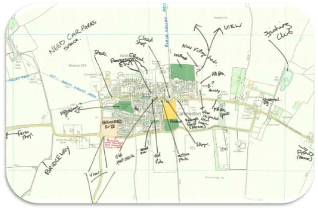
Figure 3: An example engagement map from Canewdon, 2016
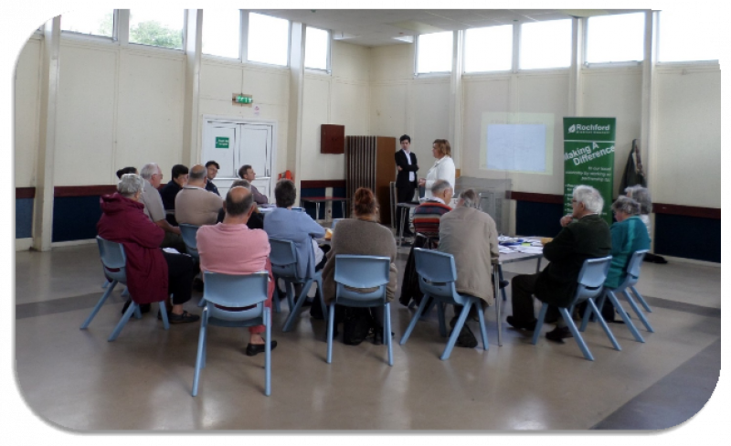
Figure 4: Photograph of community engagement event in Canewdon, 2016
How does this relate to other plans and strategies?
Whilst the new Local Plan will be limited to the authority area of Rochford, it is important to recognise that the lives and livelihoods of local residents and businesses do not cease at our boundary. Our communities have strong economic ties to areas such as Southend, Castle Point, Chelmsford and Basildon, and further afield to London, whilst many residents of those areas enjoy visiting Rochford for its unique historic, coastal and natural spaces.
In Summer 2017, the Leaders and Chief Executives of South Essex councils (Basildon, Brentwood, Castle Point, Rochford, Southend-on-Sea, Thurrock and Essex County Council) embarked on a process to develop a long-term growth ambition that would underpin strategic spatial, infrastructure and economic priorities across the region. This included establishing the Association of South Essex Local Authorities (ASELA) and agreeing a Memorandum of Understanding setting out a positive forward vision for South Essex.

ASELA has since published a Growth and Recovery Prospectus which establishes a number of projects that will help to deliver economic growth and better standards of living across the entirety of South Essex.
One such project includes the creation of a South Essex Plan, a framework covering the six authority areas, including Rochford. The scope of the South Essex Plan is evolving over time, but it is likely to set a high-level framework for how South Essex will grow over the next 20 years, whilst addressing key cross-boundary issues and opportunities that cannot be effectively addressed by local authorities working alone. This project is supplemented by an emerging housing delivery partnership which seeks to unlock stalled sites.
The District also falls within the South Essex Foreshore area of the Government-backed Thames Estuary 2050 Growth Board, which recognises over the past few decades the Thames Estuary has been unable to deliver the same levels of economic growth as other parts of the UK. The Commission's vision for South Essex is that:
"The rich patchwork of places which form the South Essex Foreshore will be celebrated. Empowered by a statutory Joint Spatial Plan the area will go beyond 'business as usual'. Locally driven town centre transformation will help create lively places that people choose to work, live, learn and play in. These policies and local initiatives will see development unlocked, post-industrial landscapes restored, and the filling of empty business spaces to create a thriving and creative economy. "
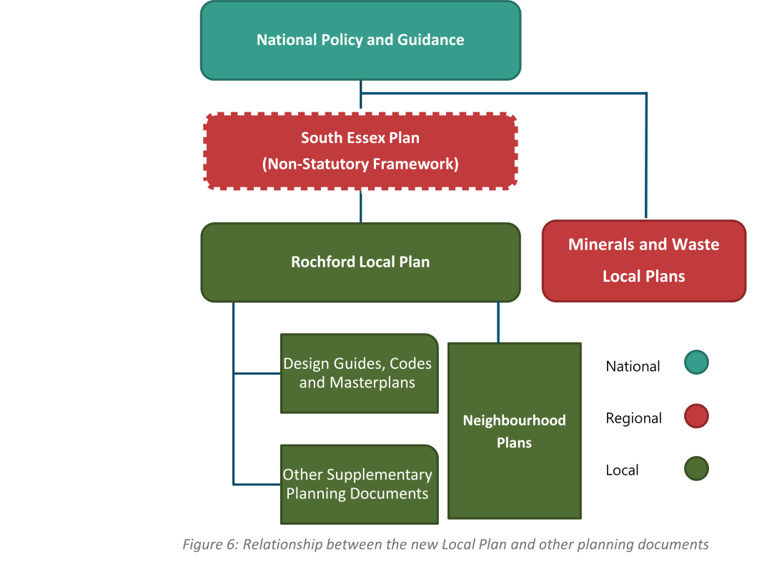
The new Local Plan will only form one part of the development plan for Rochford. Figure 6 shows the relationship between the different documents that will together form the Rochford development plan. In order for the plan to be effective and co-ordinated, it is important that the Council continues to work constructively with both Government and neighbouring authorities, both in South Essex and beyond, to ensure that the plan can help to deliver transformational opportunities for Rochford and its residents.
Beyond plan-making, there are a number of important plans and strategies that the Council's plan will need to respond to under the Duty to Co-operate. These include:
- Working alongside Essex County Council, as the upper-tier authority for the District, to ensure that its strategies and investment priorities (including those relating to highways, sustainable travel, schools, early years and childcare, public health, flooding, minerals and waste planning and social care) are effectively co-ordinated with the Council's planning strategy and priorities
- Working alongside neighbouring local authorities to ensure that regional housing issues, including level and distribution of housing and the need for specialist accommodation, is addressed effectively
- Working alongside neighbouring local authorities to ensure that the regional needs of traveller and travelling showpeople groups are effectively met, including exploring the potential for a transit site within Essex
- Working alongside neighbouring local authorities and SELEP to ensure that regional economic opportunities, including major inward investment and key assets like London Southend Airport, are supported through the planning system and elsewhere
- Working with Highways England to ensure that the potential connectivity and economic benefits of the Lower Thames Crossing for local residents and businesses are realised
- Working with Bradwell B to ensure that challenges and opportunities relating any long-term nuclear power proposals are resolved to the benefit of the District's residents, businesses and natural environment
- Working with infrastructure and service providers to ensure plans and investment are co-ordinated both locally and regionally to deliver transformational improvements wherever possible (including to the highway and sustainable transport network)
- Working alongside the Marine Management Organisation to ensure the new Local Plan aligns and responds to the South East Inshore Marine Plan
- Working alongside any neighbourhood planning groups established and supporting the delivery of sustainable, locally-led strategies through neighbourhood plans
What is the Duty to Co-operate, in simple terms?
The Localism Act legally requires certain public bodies to co-operate with each other to deal with important cross-boundary issues. If these issues are not dealt with effectively, a council’s Local Plan might be rejected by the Government.
These cross-boundary issues are not set in stone but might include the need to provide enough houses and jobs in an area, or the need to address issues affecting infrastructure that is regionally-important (such as key roads) or nationally-important (such as power stations or airports).
What is the role of evidence and the Integrated Impact Assessment?
The new Local Plan will need to set a strategy for how Rochford District should grow and develop into the future. To ensure we make the right decisions, a wide range of evidence documents have been prepared, or will be prepared in the future.
The Spatial Options document has been informed by a range of evidence, including:
- Economic Development Needs Assessment (EDNA) (to be updated)
- Green Belt Study
- Gypsy, Traveller and Travelling Showpeople Accommodation Assessment (GTAA)
- Housing and Economic Land Availability Assessment (HELAA)
- Initial Heritage Assessment (to be updated)
- Initial Transport Assessment (to be updated)
- Joint Strategic Needs Assessment
- Landscape Character, Sensitivity and Capacity Study
- Level 1 Strategic Flood Risk Assessment (SFRA)
- Local Wildlife Sites Review
- Open Space Study (emerging)
- Playing Pitch and Built Facility Studies
- Settlement Role and Hierarchy Study
- Site Appraisal Note
- South Essex Green and Blue Infrastructure Study
- South Essex Infrastructure Position Statement
- Strategic Housing Market Assessment (SHMA) (to be updated)
- Urban Capacity Study
A range of evidence is also planned to be commissioned in the near future, to help support future stages of the new Local Plan. These include:
- Whole Plan Viability Study
- Infrastructure Delivery and Funding Plan
- Level 2 Strategic Flood Risk Assessment
- Local Cycling and Walking Infrastructure Plan
- Design Guides / Masterplans
- Green Belt / Biodiversity Net Gain Assessments
The role of this evidence is not to make decisions for the new Local Plan, but rather to analyse the planning issues that the District faces relating to a particular theme or topic, and to consider the relative impacts of different solutions. These documents are often of a technical nature, and the Council has published a series of topic papers to help summarise their key findings.
The Spatial Options paper has also been informed by an Integrated Impact Assessment (IIA). The IIA will satisfy the regulatory assessment aspects of Sustainability Appraisal (SA) and Strategic Environmental Assessment (SEA), whilst also including an assessment of the health and equalities impacts of the new Local Plan. A draft IIA has been published for consultation alongside the Spatial Options paper and includes an assessment of how the options set out within the paper perform in sustainability and other terms. Information on how to provide comments on the IIA are set out in the next section.
SA is an iterative process which is closely integrated with the overall process of preparing a Local Plan. The Council has previously published an SA Scoping Report and an SA of its Issues and Options document. The role of the SA is to achieve sustainable development by assessing the likely significant effects of the plan and the extent to which the plan, when judged against reasonable alternatives, will contribute or otherwise to the achievement of environmental, economic and social objectives.
As plan-making progresses, the Council will also be required to prepare a Habitat Regulations Assessment (HRA) which will assess the new Local Plan's impact on internationally designated sites for nature conservation.
Why is preparing a new Local Plan important?
The Government has set an expectation in law, through the Neighbourhood Planning Act 2017, that every area must be covered by a (local) plan. More recently, the Government made clear its expectation that all areas should have a local plan in place by the end of 2023.
The Government provides a broad framework for national planning through the National Planning Policy Framework (NPPF).
The NPPF states that the planning system should be genuinely plan-led. It requires that succinct and up-to-date (local) plans to provide a positive vision for the future of each area; a framework for addressing housing needs and other economic, social and environmental priorities; and a platform for local people to shape their surroundings.
In addition to a range of development management policies, the NPPF makes clear that local plans should set a strategy for managing the pattern, scale and quality of new development and make sufficient provision for housing, employment, retail, leisure, infrastructure and community facilities, alongside conserving and enhancing the natural, built and historic environments.
In order to be found sound, the NPPF requires local plans to be deliverable, consistent with national policy, positively prepared (meeting identified needs for housing and other development) and justified by evidence.
The Government has made it clear that it will intervene in local authorities which do not make satisfactory progress with plan-making. At the very least, it is expected that local authorities that fail to have a (new) local plan in place by the end of 2023 may face intervention, potentially losing local control over planning decisions. It is therefore important that the Council makes suitable progress with its new Local Plan to ensure that local discretion on planning issues can be maintained.
In addition to the potential for Government intervention, there are a number of other reasons why preparing a new Local Plan is important. These are:
- To ensure that policies are up-to-date and take account of local priorities at the time of decision-making (as opposed to the time the last plan was adopted)
- To ensure that there is a sufficient supply of development (including housing) to avoid the presumption in favour of sustainable development applying (whereby the council may be obliged to approve developments it would ordinarily refuse)
- To ensure there is a sufficient supply of local commercial premises to support economic growth and avoid established businesses leaving the District
- To ensure that new community facilities and infrastructure is co-ordinated with development through a robust and costed strategy, to avoid making ad hoc decisions based on out-of-date policies
In 2020, the Government consulted on Planning for the Future, commonly referred to as the "Planning White Paper". This consultation included a wide range of proposed reforms to the planning system, including to the role of local plans and the process for preparing them. At the current time, it is not known how many of these reforms will ultimately be introduced, therefore it is considered prudent to continue preparing the new Local Plan within the confines of the existing system. However, there are a number of proposed reforms that are compatible with the process being followed, or which follow the same broad logic. As a result, wherever possible, the options within this paper have taken account of potential areas of compatibility under any new system to ensure the Council's plan-making process is as resilient to change as possible.
What is the NPPF, in simple terms?
The National Planning Policy Framework (NPPF) is a document produced by the Government which sets out its priorities and policies for planning in England. These include requirements relating to how local plans must be prepared, alongside general rules for how the Government wants local councils to take certain issues into account when making decisions.
How can I have my say?
The Spatial Options document, and its accompanying Integrated Impact Assessment (IIA), is out to consultation for a period of 6 weeks. The consultation will close at 5pm on Wednesday 22nd September 2021.
You can have your say in a number of ways, including:
- Using our online consultation portal at https://rochford.oc2.uk
- By emailing spatialoptions@rochford.gov.uk
- By writing to Strategic Planning, Council Offices, South Street, Rochford, SS4 1BW
The document includes a number of questions intended to provide structure to your feedback. These are indicated by a red box with a pen icon. You are not required to respond to every question and may wish to focus on those which are of greatest interest to you.
The simplest and easiest way of returning comments is by using our online consultation portal. However, you can view a physical version of the consultation material at Council offices and local libraries during opening hours. Please note these hours may be restricted due to the ongoing Covid pandemic.
Please note, we are unable to accept anonymous comments, therefore you must ensure you include your name and contact details alongside your comments. Your comments will be published online alongside your name; however no other details will be included.
We also reserve the right to reject abusive, discriminatory, or late comments.
Next Steps
Once the consultation has closed, we will consider all comments received and confirm those that are duly made.
We will publish a Feedback Report as soon as possible after the end of the consultation, summarising the comments received and providing an initial response to any issues raised.
To stay up to date, you are strongly encouraged to sign up to our planning mailing list at www.rochford.gov.uk/tellmemore