New Local Plan: Spatial Options Document 2021
 Green and Blue Infrastructure
Relevant Plan Objectives: 9, 11, 15, 16, 19
Green and blue infrastructure relates to our network of natural and coastal environments. These are spaces that can contribute to the health and well-being of our communities in a number of ways, including through providing opportunities for leisure and recreation, providing attractive environments for tourism and investment and encouraging more active, sustainable lifestyles by creating connections for both people and wildlife.
National policy is clear that plans should take a strategic approach to green (and blue) infrastructure to help promote active and healthy lifestyles, combat climate change and alleviate air quality issues.
Through the plan, it is important to consider where and what opportunities exist to grow and enhance our strategic green and blue infrastructure networks alongside future growth. By maximising opportunities for green and blue infrastructure we can help to achieve multiple benefits for our existing and future communities, including to:
- Provide a realistic and sustainable alternative to car use through a connected network of public rights of way and greenways
- Help to mitigate the impacts of future development by securing net gains for nature and air quality
- Improve the health and well-being of our residents by providing environments conducive to leading active lifestyles
- Grow our rural and coastal economies by providing new opportunities for tourism and commerce
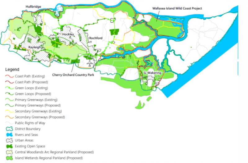
Figure 32: Map of Key Green and Blue Infrastructure Assets
Our green and blue infrastructure network comprises a wide variety of different types of space, including formal parks of different sizes, informal green areas, the open countryside and coastal environments. This section is focussed on strategic green and blue infrastructure, including how all of these spaces are connected and function as a wider network. More specific commentary on local green spaces and spaces for biodiversity is set out in separate sections.
Feedback from the Issues and Options consultation was generally supportive of improving green and blue infrastructure through the plan, with common concerns raised including:
- Severance and lack of connectivity between public rights of way means the existing network does not function as a reliable or coherent option for active travel
- Locational deficiencies in accessibility and provision have a direct negative impact on the health and well-being of residents
- A lack of facilities in spaces outside of the main settlements restricts their attractiveness as leisure and tourism destinations
The Council's existing development plan supports two key strategic green infrastructure projects, the RSPB Wallasea Wild Coast Project and Cherry Orchard Country Park. The establishment of these projects has been supported through the planning system and dedicated policies could be included in the plan to enable these projects to continue to be supported.
The South Essex Green and Blue Infrastructure Strategy (SEGBIS) identifies a number of additional projects across South Essex that can together help to address green and blue infrastructure in a strategic sense. This includes working towards a continuous South Essex Estuary Park, comprised of a number of regional parklands and proposed primary and secondary 'greenways'. These regional parklands include two main areas in Rochford, including:
- The Central Woodlands Arc – a swathe of land from the south of Rochford to the west of Hullbridge building from the existing, partially-connected green areas of Cherry Orchard Country Park, Hockley Woods and Grove Wood
- The Island Wetlands – a swathe of land from the north of Shoeburyness to the north of Canewdon building from a range of existing green and blue areas including Wallasea Island and the shorelines of the Rivers Roach and Crouch
Regional parkland does not necessarily mean that such areas would be entirely given over to public access but could be supported through the plan by restricting the influence of urbanising development and improving access through more connected and permeable rights of way.
Rochford is also home to part of the Government's coastal path project which aims to deliver a continuous coastal path around the country. Once completed, the coastal path project will open up parts of our coastal environments helping to support coastal communities and creating new opportunities for leisure and recreation for both existing residents and visitors from elsewhere.
OPTIONS - Non-exclusive options for addressing green and blue infrastructure through the plan, include:
- Allocating specific areas of land for strategic green and blue infrastructure through the plan, including the RSPB Wallasea Wild Coast Project, Cherry Orchard Country Park and those areas identified as priorities in the SEGBIS, and providing for the specific enhancement and protection of this infrastructure through one or more specific policies
- Identifying general objectives for strategic green and blue infrastructure through the plan, and providing for the general enhancement and protection of this infrastructure through one or more general policies
- Setting a strategy for the delivery of new and enhanced green and blue infrastructure, by:
- Requiring certain new developments to provide local green and blue infrastructure on-site, including to mitigate the specific local impacts of the development and contributing to the achievement of environmental net gains
- Requiring certain new developments to contribute to off-site strategic green and blue infrastructure projects, including enhancing the wider strategic green and blue infrastructure network to mitigate the impacts of new development and contributing to the achievement of environmental net gains
- Working with neighbouring authorities to explore opportunities to address green and blue infrastructure across administrative boundaries