New Local Plan: Spatial Options Document 2021
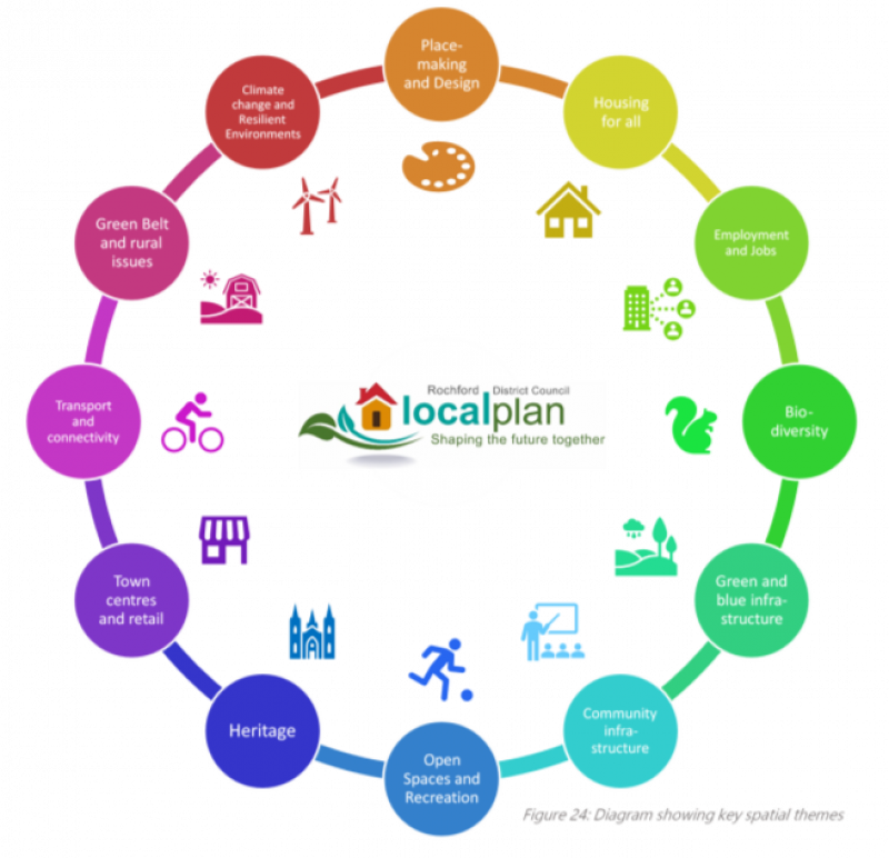
Spatial Themes
We recognise that there is far more to good planning than simply housing and jobs. This section of the consultation paper considers a range of themes that together lead to sustainable development. These themes include important issues relating to our society, our economy and our environment. Each theme within this section sets out a range of facts, challenges and opportunities relating to planning for that theme, alongside a number of questions that seek your feedback on how you feel we should be planning for that theme.
A series of topic papers have been produced in order to set out useful background information relating to these spatial themes.
Throughout this section you are encouraged to consider how the theme could be supported by your preferred Strategy Option from the previous section.
 Climate Change and Resilient Environments
Relevant Plan Objectives: ALL
Our local plan is one of the most important tools we have to support our transition to a more sustainable and resilient District, including in relation to flooding, coastal change and protecting landscapes.
The Planning and Compulsory Purchase Act 2004 requires plans to include policies designed to ensure that the development and use of land in the local planning authority's area contribute to the mitigation of, and adaptation to, climate change. National policy makes it clear that plans should take a proactive approach to mitigating and adapting to climate change, taking into account the long-term implications for flood risk, coastal change, water supply, biodiversity and landscapes, and the risk of overheating from rising temperatures.
There are a number of ways in which the planning system can contribute to creating a more resilient natural environment, including in relation to climate change. Examples are:
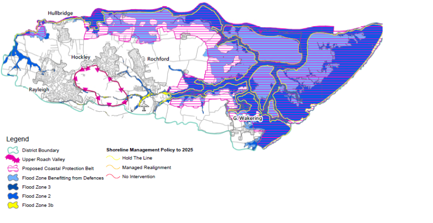
Figure 25: Map of Key Flood Risk and Coastal Change Areas and Sensitive Landscapes
- Ensuring that the distribution of new development is safe for its lifetime and encourages use of sustainable modes of transport, including walking and cycling, and reduces reliance on private car
- Increasing the supply of renewable and low carbon energy and heat, by identifying suitable areas for energy creation and ensuring new development is sustainably built
- Promoting low carbon and energy efficient development, including ensuring buildings are energy efficient for their lifetime
- Encouraging responsible use of land in areas at risk of flooding and coastal change, and consider ways that development can help to deliver net gains for flood risk alleviation
Flooding is a relevant issue for Rochford, with much of the land along our coast and rivers being at more than 1-in-1000 year risk of flooding. National policy requires a sequential approach to be taken to development, prioritising areas at least risk of flooding. Where appropriate, development will need to deliver sustainable drainage systems, such as ponds, swales and soakaways. A Level 1 Strategic Flood Risk Assessment has been prepared which will need to inform the plan's strategy in relation to the use of land in areas at risk of flooding. Once a strategy has been selected, a Level 2 Strategic Flood Ris
Assessment will be required to consider the specific flood risk and mitigation of potential development sites.
In addition to flood risk from tidal, fluvial and other sources, Rochford is a district that is likely to be subject to a coastal change as a result of climate change. The Essex and South Suffolk Shoreline Management Plan identifies parts of Rochford's coast which are subject to no active intervention or managed realignment, including around Wallasea Island and Paglesham. The plan will need to consider the implications of coastal change over a long period of time and ensure that current and future communities are. Plans are able to identify Coastal Change Management Area where rates of coastal change are likely to be significant over the next 100 years and restrict development which takes place in these areas.
There are a number of ways in which the planning system can encourage buildings to be built to low carbon and energy efficient standards. The Planning and Energy Act 2008 allows plans to set minimum standards for new housing that exceed the basic Building Regulations up to equivalency with Level 4 of the Code for Sustainable Homes, and up to no limit for commercial development. Our current plan requires commercial buildings to be built to the BREEAM 'Very Good' standard, subject to viability. The same Act also allows plans to require a proportion of energy used in a development to be sourced from renewable or low-energy sources. The Government is considering introducing a Future Homes Standard which aims to mandate net-zero carbon homes by 2050, with 'zero carbon ready' homes expected to be standard by 2025.
National policy also requires plans to facilitate the sustainable use of minerals. Whilst minerals planning is undertaken by Essex County Council, the Council's new Local Plan will need to complement minerals planning policies, including the application of Minerals Safeguarding Areas and Minerals Consultation Areas within the District.
More broadly, a resilient natural environment will also require protection and enhancement of important local landscapes over the course of the plan period and beyond. National policy is clear that plans should recognise the intrinsic character and beauty of the countryside, and that plans should provide for the conservation and enhancement of landscapes. Where landscapes have a particular local value, it is important that plans identify their special characteristics and be supported by proportionate evidence. Policies may set out criteria against which proposals for development affecting these areas will be assessed. Rochford is not home to any Areas of Outstanding Natural Beauty (AONB) or National Parks, but nonetheless has areas of locally special landscape character. These include the Coastal Protection Belt and Upper Roach Valley. We have prepared a Landscape Character, Sensitivity and Capacity Study to consider the landscape character and sensitivities of different areas. The Study suggests that the Coastal Protection Belt should continue to be protected for its special coastal landscape value, subject to a modest redrawing. The Study also identifies the Upper Roach Valley area as the most sensitive non-coastal landscape in the District. This Study will be an important source of evidence in considering the particular sensitivities of different landscapes and how landscape should be managed through the plan, including when determining where development should be located.
OPTIONS - Non-exclusive options for addressing climate change and resilient environments through the plan, include:
- Ensuring that the Plan strategy takes a sequential approach to flood risk including to locate vulnerable development away from areas at greater risk of flooding where possible
- Supporting the delivery of on-site sustainable drainage systems to ensure that new developments do not worsen flood risk elsewhere and, where possible, lessen the risk
- Requiring certain new developments to source a proportion of their energy from renewable and low-carbon sources
- Designating appropriate locations within the District for low-carbon and renewable energy generation projects
- Identifying areas with special landscape character, such as the Coastal Protection Belt and Upper Roach Valley, and protecting them from inappropriate development through the plan
- Ensuring the plan supports the principles of the Essex and South Suffolk Shoreline Management Plan, including to consider designating coastal change management areas and ensuring the distribution of new development is compatible with planned coastal change
- Requiring new development to be carbon neutral wherever possible, including as a first step requiring new houses to be built to an energy efficiency standard equivalent to Level 4 of the Code for Sustainable Homes and new commercial developments to be built to BREEAM Excellent standard, and moving towards any net-zero standards introduced by Government at the earliest opportunity
(57) Q10. Do you agree that the Coastal Protection Belt and Upper Roach Valley should be protected from development that would be harmful to their landscape character? Are there other areas that you feel should be protected for their special landscape character? [Please state reasoning]
(58) Q11. Do you agree we should require development to source a percentage of their energy from low-carbon and renewable sources? Are there other opportunities in the District to supply low-carbon or renewable energy?
(69) Q12. Do you agree we should require new development to achieve energy efficiency standards higher than building regulations? What level should these be set at? [Please state reasoning]
(33) Q13. How do you feel the plan can help to support the local generation of low-carbon and renewable energy? Are there locations where you feel energy generation should be supported? [Please state reasoning]
Place-making and Design
Relevant Plan Objectives: ALL
Rochford is a visually diverse area with a unique mix of historic, natural and urban environments that help to create a distinctive local vernacular and character.
The creation of high-quality buildings and places is fundamental to what the
planning and development process should achieve (NPPF, Para 124). National policy is clear that good design is a key aspect of sustainable development which helps to create better places in which to live and work. National policy further requires plans to be clear about design expectations, and how these will be tested, with effective engagement between applicants, communities, local planning authorities and other interests throughout the process.
However it is important that the plan considers the issues that make a successful place beyond just the design of buildings and spaces. Successful place-making within both our existing and future communities will need to be at the heart of our vision for the District, alongside the vision for our individual towns and villages.
Successful place-making relies on a range of different factors coming together to create places that are attractive, vibrant and safe.
To help direct these different factors, the Plan could include a place-making charter, setting out a number of key principles for how development is expected to come forward in a way that contributes positively to its setting and wider environment. This place-making charter could form the basis for specific design policies, alongside one or more design guides (or codes) that set rules for how different parts of the District are expected to develop. These policies, guides and codes could set strict rules for some types of development in more sensitive locations, whilst allowing greater innovation and freedom for other forms of development in other locations. The scale and geography of these design guides and codes will be important to their success; a single guide could be prepared to cover the entire District, or we could prepare individual design guides and codes for specific settlements or areas.
A PLACE-MAKING CHARTER FOR ROCHFORD
New development will be required to…
✓ Deliver high-quality design and architecture in all buildings, streets and spaces;
✓ Achieve carbon-neutrality and, where possible, carbon negativity by promoting the use of renewables, providing for future methods of transport and minimising energy and water use throughout the lifetime of buildings;
✓ Provide opportunities and activities for all groups in the community;
✓ Improve health and wellbeing by encouraging active travel and securing access to multi-functional, accessible and connected green and blue spaces, including parks and coastal areas;
✓ Encourage low-levels of car reliance, with a focus on prioritising sustainable forms of movement including walking and cycling;
✓ Conserve and enhance heritage features and local character;
✓ Support the creation of walkable and complete communities through the co-location of community facilities and delivering appropriate and accessible social infrastructure, including for education, healthcare and energy provision;
✓ Design developments so they are inclusive and safe for all users at all times;
✓ Improve affordability and choice by providing for a mix of typologies and tenures in housing supply;
✓ Enable inclusive and sustainable economic growth for different types and size of business, including by enabling ultra-fast connectivity to homes and premises;
✓ Avoid worsening air quality and to improve local air quality wherever possible;
Ensure all buildings are resilient to the potential future impacts of climate change throughout their expected lifetime;
✓ Encourage social innovation and opportunities for community-led projects;
✓ Facilitate the responsible long-term management and stewardship of places
The Council has not prepared any specific evidence on design or place-making to inform its new Local Plan but may need to do so as plan-making progress. However, given the wide range of issues that contribute to successful place-making, it is likely that the evidence base will need to come together as a whole to inform our place-making and design policies, including evidence on housing need, green and blue infrastructure, viability and climate change.
Through the Issues and Options consultation, a number of options were presented including to retain existing District-wide policies and guidance, revise existing District-wide policies and guidance or to develop new area-specific policies and guidance. There was no consensus on a preferred way forward, but a number of common themes were identified including a widely held agreement that good design was central to successful place-making and the need to make best use of industry best practice on design, such as the UK Police Service's Secured by Design, Sport England's Active Design Principles and the Essex Design Guide.
Possible changes to the planning system being considered by Government include placing a much greater emphasis on design in the planning process, with each area having design guides or codes, alongside specific masterplans for large growth areas. Regardless of whether these changes are formally introduced, there are a number of existing and emerging guides that can help to inform the Council's approach to place-making and design, including those listed above, and those below:
- National Design Guide
- National Model Design Code (emerging)
- Manual for Streets
OPTIONS - Non-exclusive spatial options for addressing place-making and design through the plan include:
- Identifying a number of general place-making principles and policies through the plan, including a potential overarching ‘charter’, that:
- relate to the District as a whole,
- relate to individual settlements, or
- relate to individual areas identified for growth
- Preparing detailed design guides, codes or masterplans alongside the plan that:
- relate to the District as a whole,
- relate to individual settlements, or
- relate to individual areas identified for growth
(52) Q14. Do you consider that the plan should include a place-making charter that informs relevant policies? Should the same principles apply everywhere in the District, or should different principles apply to different areas? [Please state reasoning]
(33) Q15. Are the principles set out in the draft place-making charter the right ones? Are there other principles that should be included? [Please state reasoning]
(46) Q16a. Do you consider that new design guides, codes or masterplans should be created alongside the new Local Plan?
(40) Q16b. If yes, do you think it is more appropriate to have a single design guide/code for the whole District, or to have design guides/codes/masterplans for individual settlements or growth areas? [Please state reasoning]
(27) Q16c. What do you think should be included in design guides/codes/masterplans at the scale you are suggesting? [Please state reasoning]