New Local Plan: Spatial Options Document 2021
Rochford in 2021
District Profile
Our Social Characteristics
Rochford is a district that is home to around 87,000 people across a mix of urban and rural settlements. Our population has grown around 4% over the last 10 years and is projected to grow by a further 12% over the next 20 years. This would make our population around 98,000 people by 2040.
Over the same period, the age structure in Rochford is expected to shift notably towards an older population. By 2040, we expect there to be a 46% increase in over 70s, with the number of people living into their 90s expected to almost double compared to current levels. There are also likely to be slightly more children than currently however the number of economically active individuals is likely to decrease with fewer residents of Rochford being between the ages of 18 and 70 than currently. This could create challenges relating to dependency, with the number of over 65s per 1,000 working people likely to increase to around 450 by 2040, far above both the projected national average of 350 and the current Rochford rate of 390. Whilst general standards of health within older populations is consistently improving, a large dependent population relative to economically active people does present challenges locally in generating economic growth and will mean a likely a shift in demand for certain local facilities and services.
Rochford is currently one of the least deprived areas in the country, with only five out of 53 local neighbourhoods falling into the top 40% most deprived in the UK and 28 falling into the top 20% least deprived. There remain however small pockets of deprivation where income, education and healthcare outcomes are notably worse than the rest of the District, including small areas within and to the east of Rochford town.
Our general standards of health are one of our strengths with 96% of residents rating their health as very good, good or fair. Life expectancy is better than both local and national averages, whilst rates of excess winter deaths, cardiovascular disease deaths and cancer deaths are lower than national averages.
The standards of education locally are generally good with the majority of local schools rated 'Good' by Ofsted, with four rated 'Outstanding' and four rated 'Requires Improvement.' However the percentage of economically active adults with no qualifications (24%) is slightly higher than the national average (23%) whilst the percentage of economically active adults with a degree (20%) is lower than the national average (27%). Rochford also has a noted skills mismatch with a large number of the jobs available locally not matching the average skillset of our residents.
The vast majority of homes in Rochford are owner-occupied (83%) with a relatively modest rental sector. The dominant house types in the area are detached (33%) and semi-detached (46%) with a relatively modest proportion of flats and terraced housing. The affordability of all housing is an issue constraining the ability for residents to afford homes in the area. The average house costs around ten times to average annual income of a Rochford resident, which has increased significantly from around five times 20 years ago and is significantly above the national average.
|
Settlement |
Population |
|
Total |
86,891 |
|
Rayleigh |
33,663 |
|
Rochford and Ashingdon |
18,420 |
|
Hockley and Hawkwell |
14,343 |
|
Great Wakering, Little Wakering and Barling |
6,225 |
|
Hullbridge |
5,870 |
|
Other (including rural populations) |
5,316 |
|
Canewdon |
1,101 |
|
Rawreth |
563 |
|
Sutton / Stonebridge |
520 |
|
Great Stambridge |
372 |
|
South Fambridge |
265 |
|
Paglesham |
233 |
Figure 7: Estimated Population of local settlements (2018)
Our Cultural Characteristics
Rochford has a number of settlements that date back hundreds of years, including our two largest: Rayleigh, which was recorded in the Domesday book, and Rochford, a historic market town with building dating back to the medieval era. Other important settlements include key centres of population in Hockley, Hawkwell and Ashingdon, large villages in Great Wakering and Hullbridge, and smaller villages and hamlets of Canewdon, Paglesham, Rawreth and Great Stambridge.
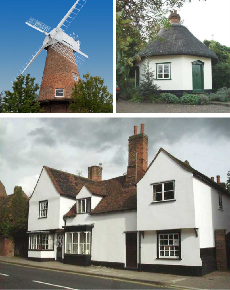
Rochford has a rich and diverse built heritage with over 300 listed buildings, including a number of centuries-old churches, halls and houses, and ten conservation areas protected for their architectural and historic importance. We are home to a number of unique and iconic buildings including the Dutch Cottage, an octagonal thatched cottage, the Old House, a medieval house dating back to the 13th century, and the Rayleigh Windmill, a one of a kind windmill turned wedding venue. The Grade I listed Rochford Hall is located to the west of Rochford town and has ties to the Boleyn Family. We also have a number of important archaeological sites, including 350 separate records on the Essex Historic Environment Record and a number of sites designated as scheduled monuments, including:
- Rayleigh Mount - the former site of a motte-and-bailey castle in central Rayleigh, now an open space managed by the National Trust
- Heavy Anti-Aircraft Gun Site, Sutton – the site of a heavy anti-aircraft gun built during World War II
- Mud Berth, Paglesham – the final resting place of the HMS Beagle, upon which Charles Darwin undertook his famous round the world voyage
In addition to our extensive heritage, we have a growing tourism sector that is supported by the unique cultural sights we can offer. With London Southend Airport being closeby and increased demand for nature-led staycations, our rural villages and sights such as RSPB Wallasea Island, are becoming increasingly attractive to date and short-stay vacationers.
The annual Wild Woods Day provides annual family activities celebrating one of the country's best protected ancient woodlands at Hockley Woods. The Discover 2020 festival is also a celebration in 2020/21 of some of the District's historic events, including the 200th anniversary of the HMS Beagle's voyage to South America.
Our Environmental Characteristics
Rochford is situated on a peninsula between the North Sea and the Rivers Thames and Crouch. The majority of the population live on the mainland, however Rochford is home to a number of estuarine islands, including Wallasea Island, an RSPB reserve, and Foulness Island, an active Ministry of Defence site. It is a generally rural district with over 12,400 hectares of land covered by the eastern extent of the Metropolitan Green Belt, in addition to the generally undeveloped area of Foulness Island which does not fall within the Metropolitan Green Belt but is nevertheless rural in nature.
Rochford is also home to around 12,000 hectares of in-land and marine habitats of international importance, mostly along the coast and eastern estuaries, with over 15% of our landmass covered by one or more biodiversity designations. These designations include the Crouch and Roach Special Protection Area, the Foulness Special Protection Area and the Hockley Woods Site of Special Scientific Interest. In addition, Rochford contains 39 sites of local wildlife importance, four local nature reserves, at Kendall Park, Marylands, Hockley Woods and Magnolia Park and a large network of public open spaces scattered throughout the district.
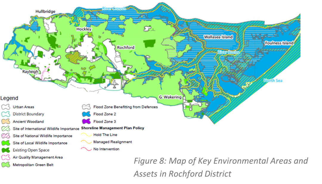
As a coastal area, with two main rivers running through it, Rochford is an area that faces threats from flooding from a variety of sources, including tidal (sea) and fluvial (rivers). Over 40% of Rochford's land area is at a greater than 1 in 1000 probability of flood risk in any given year, whilst the sea level rises that climate change is predicted to cause threaten our coastline, particularly to the east of the District.
Some areas have also been identified in the Essex and Suffolk Shoreline Management Plan as being appropriate for managed shoreline realignment, including at Wallasea Island and Paglesham.
Rochford also has some more localised environmental issues, including an air quality management area on Rayleigh High Street that was designated in 2015. An Air Quality Action Plan is now in place for this area, making targeted interventions to return air quality to a safe standard.
Our Economic Characteristics
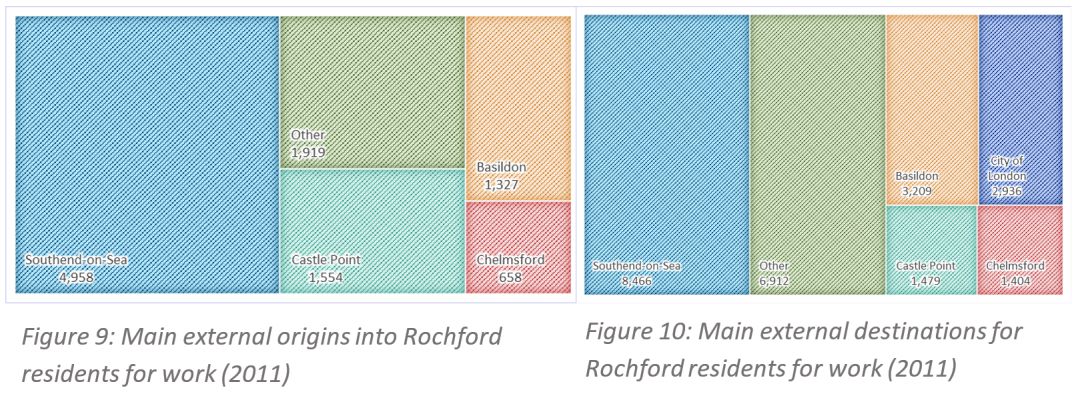
We have a small but productive local employment offer, with over 3,500 businesses of which 90% employ fewer than ten people. Our job density of around 0.59 jobs to every working age resident is relatively low compared to a national average of 0.87, reflecting our strong reliance on out-commuting to other areas including Chelmsford, Basildon, Southend-on-Sea and London. However, the average weekly earnings of our residents (£649) is favourable compared to the annual average of £569, reflecting again our relatively good access to high-paid skilled jobs in London and elsewhere. (Statistics from NOMIS 2019)
There are currently around 22,000 jobs located in Rochford. Our key sectors by number of employees include retail (around 16% of workforce), education (11%), manufacturing (10%) and construction (9%), with a notable clustering of specialist businesses in the aviation and specialist manufacturing sectors.
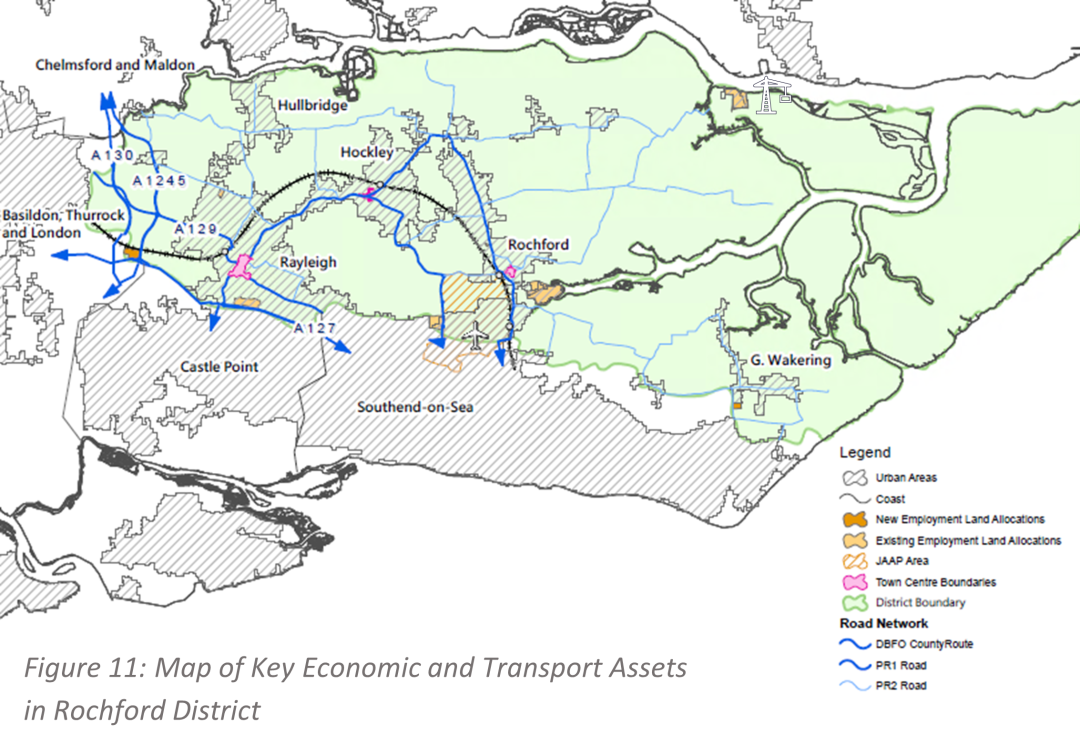
We are connected to the rest of South Essex and beyond by two main road connections: the A127, travelling east to Southend and west to Basildon and London, and the A130, travelling north to Chelmsford and south to Canvey Island and Thurrock. These roads connect further afield to important onwards networks including the A12, A13 and M25. In addition, our three main towns of Rayleigh, Rochford and Hockley, along with our growing regional airport, London Southend Airport, benefit from a regular rail services to London and Southend with further connections to the Elizabeth Line and Great Eastern Mainline from an interchange at Shenfield. Our local economy is supported by two notable economic assets, the passenger and commercial ports of London Southend Airport and Baltic Wharf. We are also strategically well-located to take advantage of the proposed Lower Thames Crossing and the creation of a new nuclear power station at Bradwell B.