Allocations DPD Discussion and Consultation Document
(1) 2. Residential
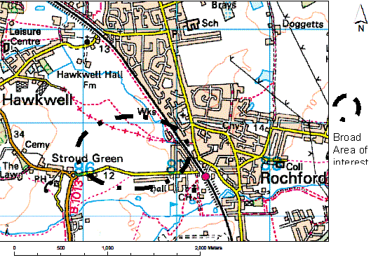
(469) Residential Land Allocations
The East of England Plan (2008) requires Rochford District to accommodate 3,790 dwellings between 2006 and 2021, at an approximate average of 250 dwellings per year. Post 2021, in accordance with PPS3, the District is required to continue the development rate of 250 dwellings per year. Accordingly, the Core Strategy sets out the approach to housing distribution to 2025. The Allocations DPD will aid the delivery of the Core Strategy through the allocation of appropriate sites for residential use. The District’s housing supply includes extant permissions and sites already allocated for housing, but additional land needs to be allocated, including appropriate brownfield sites where the current allocation is non-residential and some green belt land
The Strategic Housing Land Availability Assessment (SHLAA) notes that 795 dwellings can be accommodated on previously developed land that is not currently allocated as residential.
The Core Strategy recognises that 2745 dwellings will have to be provided on land which is currently allocated as Green Belt by 2025.
The Core Strategy Submission Document has detailed 9 general locations for extensions to residential envelopes. These locations and the respective quantum of development are as follows:
| Area | Dwellings by 2015 | Dwellings 2015-2021 | Dwellings post 2021 |
|---|---|---|---|
|
North of London Road, Rayleigh |
0 |
550 |
|
|
West Rochford |
450 |
150 |
|
|
West Hockley |
50 |
0 |
|
|
South Hawkwell |
175 |
0 |
|
|
East Ashingdon |
100 |
0 |
|
|
South West Hullbridge |
0 |
250 |
250 |
|
South Canewdon |
0 |
60 |
|
|
South East Ashingdon |
500 |
||
|
West Great Wakering |
250 |
||
|
Total |
775 |
1010 |
1000 |
In January 2007 the Council opened a “Call for Sites” process which enabled residents, landowners, and agents to put forward sites that were to be considered for development. As part of this, the Council received over 200 potential sites. Each of these sites was assessed on its own merits. A full list of sites and accompanying maps and assessments can be found in Appendix 1 of this document.
(8) Sites identified in the Strategic Housing Land Availability Assessment as being suitable for housing
The Council recognises the importance of making best use of brownfield land. The Strategic Housing Land Availability Assessment (SHLAA) identifies a realistic figure that can be accommodated within existing settlements and other appropriate land, based on the identification of specific sites.
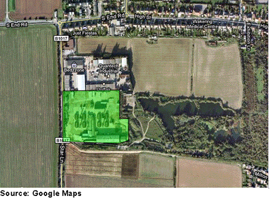
The SHLAA examines four sites that are currently allocated for employment: Eldon Way/Foundry Industrial Estate, Hockley; Rawreth Lane Industrial Estate, Rayleigh; Stambridge Mills; and Star Lane Industrial Estate and Brickworks, Great Wakering. In the case of all four sites, the Council believe that their redevelopment for alternative uses, including residential, represents a more appropriate use of the land.
(19) Residential Allocations – Options
The following outlines options for the allocation of land that has the potential to deliver housing in the locations and at the quantums set out in the Core Strategy.
It may be necessary to phase the delivery of residential development, to ensure that the required infrastructure is delivered alongside it. This may mean that infrastructure requirements are detailed at a later date alongside a certain proportion of housing, and unless that infrastructure is in place, further housing cannot be delivered.
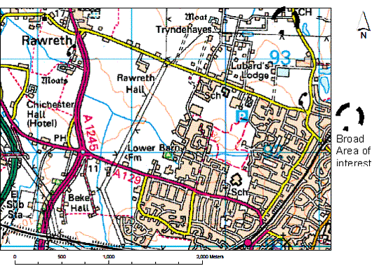
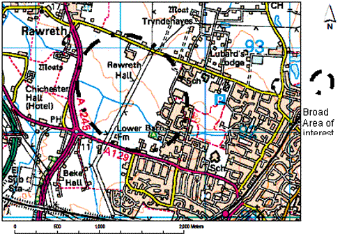
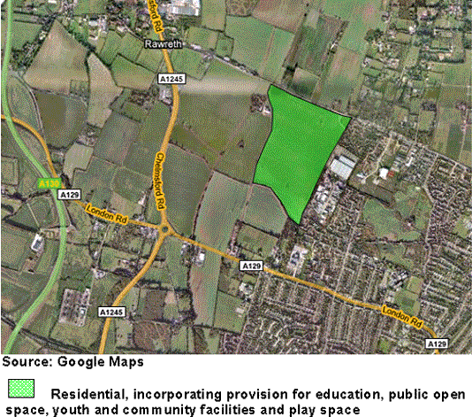
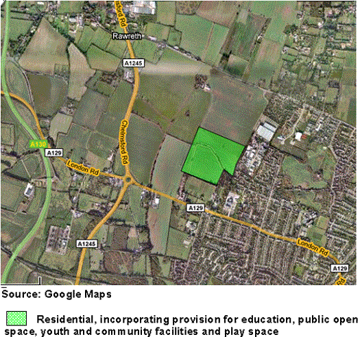
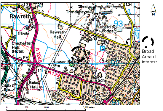
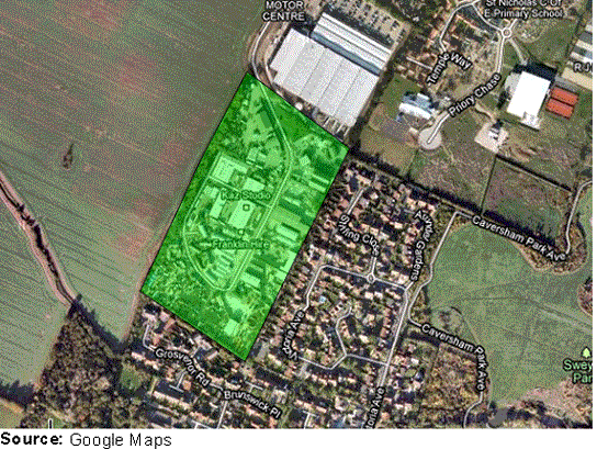
(204) North of London Road, Rayleigh 550 dwellings
Issues:
Allocation required for:
- 550 dwellings
- Primary School
- Public park land providing buffer between future built environment and A1245
- Youth and Community Facilities
- Play Space
(59) Option NLR1
The site is adjacent to settlement of Rayleigh, and is bounded to the west by A1245 Chelmsford Road, to the south by London Road and to the north by Rawreth Lane. Adjacent land uses include residential to the east, and agricultural to the west and to the north.
There are several pylons throughout site, which will need to be relocated. Some parts of area are in flood zone 3 and a foul sewer is located on the site, which would need to be accounted for and incorporated into the development. The site, if developed, would constitute an urban extension of the residential settlement to the east. The quantum of housing this site has the capacity for will ensure that suitable community benefits can be sought. The Core Strategy Submission Document states that infrastructure requirements from the development of this site are as follows: local highway capacity and infrastructure improvements, improvements to public transport service and infrastructure, enhancement and links to the pedestrian, cycle and bridleway network.
There is good access to the transport network although the impact of increased traffic on surrounding highway network will need consideration. Consideration of a primary school within the site, alongside allotments, community and public open space is necessary.
The site has sufficient capacity to deliver significant community benefit to the nearby town of Rayleigh and the additional dwellings would be adjacent to an existing residential area. There is also capacity to provide a green buffer between the built environment and the A1245. The development of this site could also potentially enable a public transport link between Rawreth Lane and London Road. The site would afford good opportunities for the creation of a strong defensible green belt boundary.
The site lies directly south of Rawreth Lane, and is adjacent to the residential settlement to the east. Consideration must be given to the area of land to the south of the site that lies within Flood Zone 3, as this land will be required to accommodate non vulnerable uses.
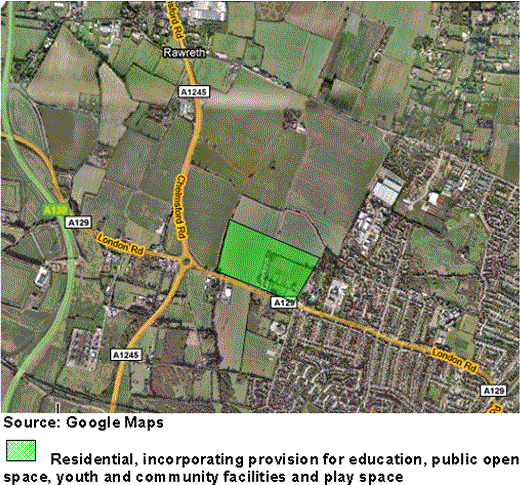
(44) Option NLR2
Option NLR2 is as per NLR1 except the site is further south of Rawreth Lane, and thus closer to London Road. Access to this site would be via London Road or the surrounding residential development. Consideration must be given to the section of the land through the centre of the site that lies within Flood Zone 3; this land will be needed to accommodate non-vulnerable uses. The site would afford opportunities for the creation of a strong defensible green belt boundary.
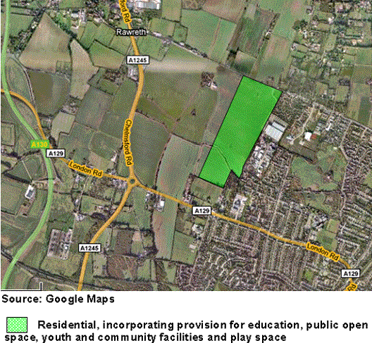
(56) Option NLR3
Option NLR3 is as NLR1 and NLR2 but directly north of the London Road. There are few pylons on this area, and the area is again adjacent to residential areas. The site would offer excellent access to the A129 and A1245, and thus the surrounding main routes. The site would afford opportunities for the creation of a strong defensible green belt boundary.
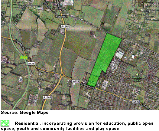
(47) Option NLR4
Option NLR4 is as NLR1 but extends from Rawreth Lane south to just north of London Road. This location would enable community cohesion due to its location adjacent to existing residential settlement. The site is also well situated in relation to town centre services and facilities and the transport network. Consideration must be given to the section of the site to the south which lies within Flood Zone 3; this will be required to accommodate non-vulnerable uses. The site would afford opportunities for the creation of a defensible green belt boundary.
(58) Option NLR5
Option NLR5 is as NLR4 except this site extends further south to London Road. This location would enable community cohesion due to its location adjacent to existing residential settlement. The site is also well situated in relation to town centre services and facilities and the transport network. Consideration must be given to the section of the site to the south which lies within Flood Zone 3; this will be required to accommodate non-vulnerable uses. This site would also enable the implementation of a bus only through route from Rawreth Lane to London Road, into Rayleigh centre. The site would afford good opportunities for the creation of a strong defensible green belt boundary.
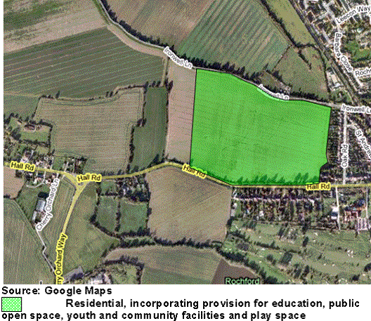
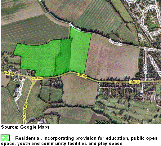
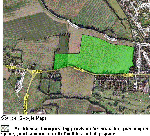
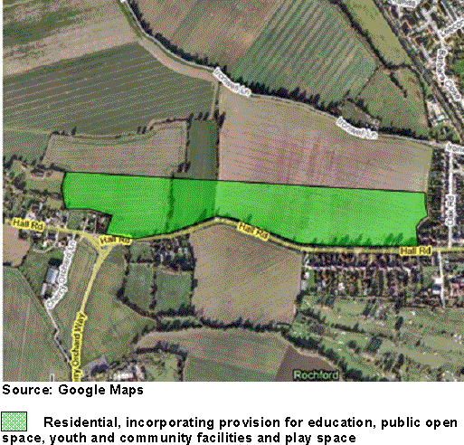
(24) West Rochford 600 dwellings
Issues:
Allocation required for:
- 600 dwellings
- Primary School
- Public open space
- Youth and community facilities
- Play Space
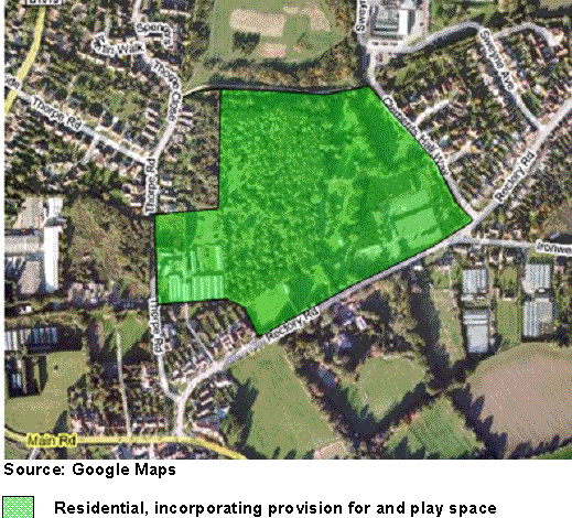
(12) Option WR1
Option WR1 is north of Hall Road and adjoins existing residential areas to the south and east. West and north of the site are agricultural fields and the site itself is currently used for agriculture purposes. The site is not subject to significant constraints that would restrict development, other than a small area in the north-east corner which is within flood zone 2.
It is within walking distance of Rochford Train Station, which provides a direct link to London Liverpool Street and Southend Victoria stations. The site is also close to bus links and Rochford town centre. The site is large enough to support the required number of dwellings from this location, and would be able to provide the community benefits as stipulated within the Core Strategy Submission Document.
The site adjoins existing residential areas and thus has the potential to integrate with the existing community. The infrastructure that could be delivered within the site has the potential to benefit the wider community. The Core Strategy Submission Document requires the following infrastructure to be implemented in developing in this location: local highway capacity and infrastructure improvements, public transport service and infrastructure improvements, Sustainable Urban Drainage Systems, and links and enhancements to local pedestrian, cycle and bridleway networks. This site has the potential to incorporate all of these, whilst also providing a defensible Green Belt boundary.
(9) Option WR2
Option WR2 is north of Hall Road and Cherry Orchard Way. Rochford Train Station is to the south east of the site which is within walking distance. East and north of the site lie agricultural fields, and west of the site are several residential dwellings. The site is detached from the residential area of Rochford, although the town centre is within walking distance. Separation from the community of Rochford may result in two distinct communities and community isolation as a consequence. The capacity of the site gives an appropriate contribution to housing targets. The site is in a sustainable location close to train station, bus links, and town centre, with suitable highways access. The Core Strategy Submission Document states that the following infrastructure will be required alongside this site: local highway capacity and infrastructure improvements, public transport service and infrastructure improvements, Sustainable Urban Drainage Systems, and links and enhancements to local pedestrian, cycle and bridleway networks. Benefits to the existing community from this site would be harder to access due to its location away from the existing settlement. The site would not afford a good opportunity for the creation of a strong defensible green belt boundary.
(7) Option WR3
Option WR3 is as WR1 except this site extends further west, and does not extend as far as Ironwell Lane to the north. Still within walking distance to the town centre, bus stops and Rochford train station the location of this site would enable a green buffer around the northern and western perimeter of the site. The site is adjacent to the current residential settlement to the east of Rochford, and thus the community would be able to see the benefits obtained from this development, and the new community would not be segregated in any way. Community cohesion would also be more achievable with this location due to its proximity to the existing settlement. However the northern edge of the site will not provide a defensible green belt boundary.
(8) Option WR4
Option WR4 is as WR1 except the site extends further west to the settlement opposite Cherry Orchard Lane and does not extend as far north as Ironwell Lane. To the south of site is Hall Road and to the south east lies Rochford Train Station which is within walking distance. East of the site lies the train line and west and north of the site lie agricultural fields. Ribbon development is not encouraged as this is considered to be not as sustainable, and in this case would result in dwellings to the furthest north west point of the site being removed from the existing community, and having to travel a lot further to reach the town centre, train station and associated services. Again, this site will not provide a natural defensible green belt boundary.
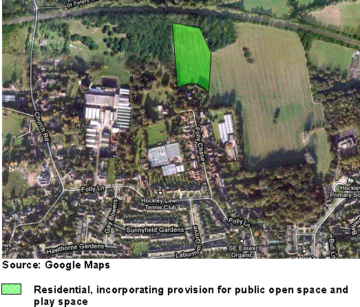
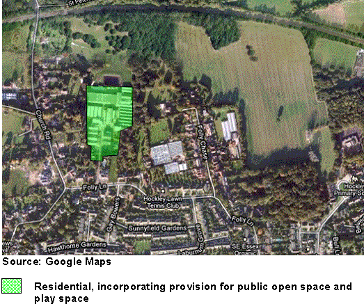
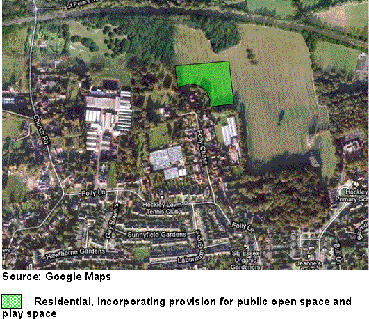
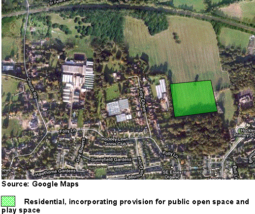
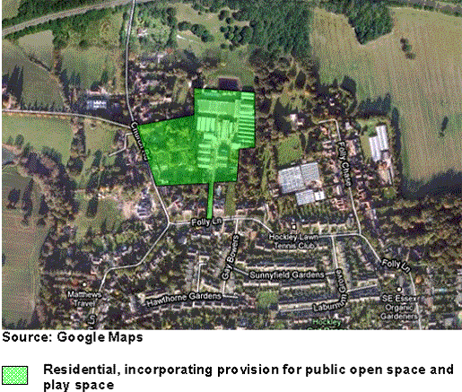
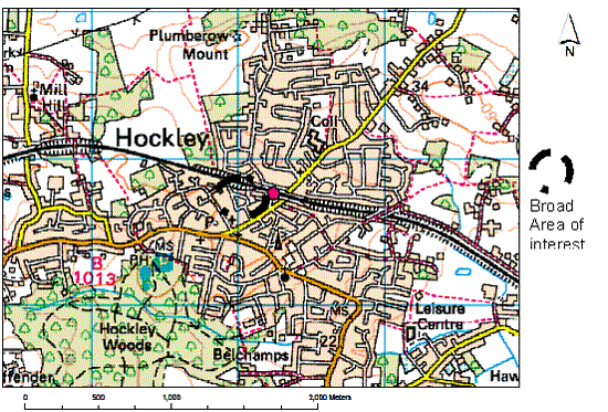
(498) West Hockley 50 dwellings
Issues:
Allocation required for:
- 50 dwellings
- Public open space
- Play space
(37) Option WH1
Option WH1 is north of residential development at Folly Chase. The site is currently disused agricultural land. To the far east of the site is a school and community centre, with the London Southend rail line to the north, containing the site. The site is bounded to the north, north east and west by a wooded area, and to the east by agricultural fields, the impact on which would need to be carefully assessed. This would however provide a defensible green belt boundary. There are no visible man made structures or pylons on the site. The location of the site with regard to impact on surrounding roads needs to be assessed –improvements will be needed to cope with the increase in traffic, although the number of dwellings the site has capacity for should provide this. The Core Strategy Submission Document states that the infrastructure required to be implemented alongside this site are: Local highway capacity and infrastructure improvements, public transport service and infrastructure enhancements, links and enhancements to pedestrian, cycling and bridleway networks, and Sustainable Drainage Systems. The site would afford good opportunities for the creation of a strong defensible green belt boundary.
(26) Option WH2
Option WH2 is currently used as a mushroom farm and for light industry just north of Folly Lane. Allocating this site for residential development would maintain the sanctity of the Green Belt as the site is Previously Developed Land. Infrastructure required from this site as stated within the Core Strategy Submission Document is: Local highway capacity and infrastructure improvements, public transport service and infrastructure enhancements, links and enhancements to pedestrian, cycling and bridleway networks, and Sustainable Drainage Systems, all of which are viable. The site is well located in terms of the transport network and the existing defensible Green Belt boundary would not be broached.
(28) Option WH3
Option WH3 is as WH1 although it follows the pattern of the existing residential dwellings and does not extend as far north, thus minimising any impact on the wooded area north and north east of the site. The creation of a defensible green belt boundary at this site would be difficult however.
(40) Option WH4
Option WH4 is as WH1 except to the east of Folly Chase as opposed to the north. The site is located directly north of Folly Wood, and is also adjacent to the school and its accompanying land. The impact of any development on these two sites must be carefully considered. The creation of a defensible green belt boundary at this site would be complicated however.
(14) Option WH5
Option WH5 is as WH2 with an extension to the west of the site. This land is currently Green Belt but would provide a defensible boundary up to Church Road, and potentially provide additional access to the site.
(17) Are these the right options?
(9) Should other sites in this location be considered?
(4) Should a mix of these sites be considered?
(8) Would it be better to locate the 50 dwellings on one of these sites or spread the dwellings between a selection of sites?
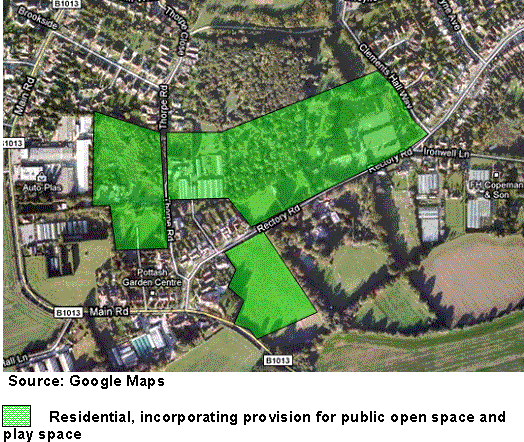
(26) South Hawkwell 175 dwellings
Issues:
Allocation required for:
- 175 dwellings
- Play Space
(10) Option SH1
Option SH1 is north of Rectory Road, Hawkwell and is currently used as a nursery. Surrounded by residential settlement, there are several large buildings throughout the site as a result of its current use. A small corner of the site is at risk of flooding, and some mature trees are present on the site, which would need to be accounted for in the design if development is taken forward. The site is within a residential settlement, and road access is currently available, although improvements will be required particularly in terms of increased traffic movements. The Core Strategy Submission Document states that improvements needed in this location are: Local highway capacity and infrastructure improvements, public transport infrastructure and service enhancements, links and enhancements to pedestrian, cycle and bridleways, and Sustainable Urban Drainage Systems. The size of the site means that the required improvements can be delivered. Development here would not erode the openness of the Greenbelt. The site is well located in terms of schools and services. The site would afford good opportunities for the creation of a strong defensible green belt boundary.
(10) Option SH2
Option SH2 is as SH1 except does not extend as far north as the footpath linking Clements Hall Way and Thorpe Close. There is also a further section of land to the west of the site adjoining Thorpe Road, which again is part of the current nursery site. The site would afford good opportunities for the creation of a strong defensible green belt boundary.
(14) Option SH3
Option SH3 is as SH2, with a section of land to the south included, instead of the section of land to the west. The additional section is currently not being used and is adjacent to residential dwellings to the north and west of the site. The quantum of housing available would result in community benefit to the area, and highways improvements, easing the impact of increased traffic. Development here would not erode the openness of the Greenbelt. The site is well located in terms of schools and services. The site would afford opportunities for the creation of a defensible green belt boundary
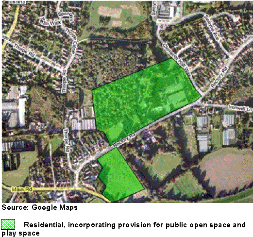
(15) Option SH4
Option SH4 is as SH1 and SH2, with the land to the west, and to the south both included with the land north of Rectory Road not extending as far north.The site would afford opportunities for the creation of a defensible green belt boundary.
(16) Are these the options we should be considering for South Hawkwell?
(5) Should other sites be considered?
(7) Should the dwellings be located on one site or a mixture of sites?
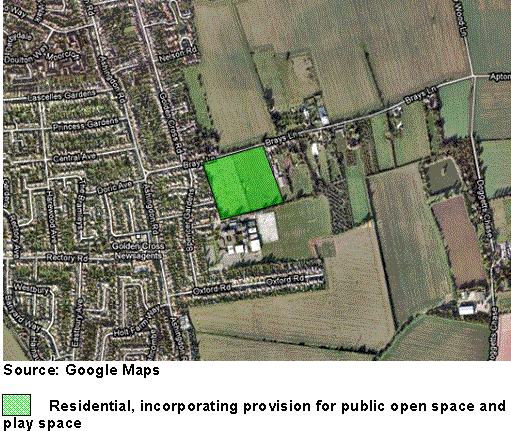
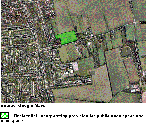
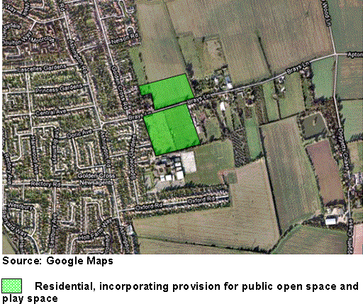
(84) East Ashingdon 100 dwellings
Issues;
Allocation required for:
- 100 dwellings
- Land made available for expansion of King Edmund School
- Improved access to King Edmund School
- Public open space
- Play space
- Youth and community facilities
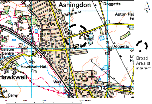
(12) Option EA1
Option EA1 is currently used as agricultural land, and the site is located immediately south of Brays Lane adjacent to residential dwelling to the east and west. The site is immediately north of King Edmunds School. Development of this site is likely to deliver educational and highway improvements needed at King Edmund School. Access implications to the school will need careful consideration as will the impact of increased traffic on the highway network. The site would afford good opportunities for the creation of a strong defensible green belt boundary.
(14) Option EA2
Option EA2 is land north of Brays Lane. The site is adjacent to residential settlement to the west, and agricultural land to the east providing a defensible boundary. This site however would not provide capacity to improve access to King Edmund School or provide land for the expansion of the school due to its location. The creation of a defensible green belt boundary in this location would be difficult however.
(12) Option EA3
Option EA3 consists of land to the north and to the south of Brays Lane. This would allow for improved access to the school, with the capacity to support the housing numbers required. However the site to the north would not provide a defensible green belt boundary.
(10) Are these sites the most suitable for development in this location?
(5) Should other sites be considered?
(4) Should development be on one site or a selection of sites?
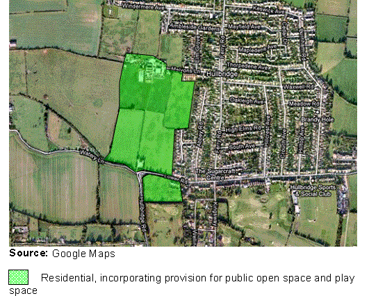
(891) South West Hullbridge 500 dwellings (250 between 2015 and 2021, and 250 post 2021)
Issues:
Allocation required for:
- 500 dwellings
- Public open space
- Play Space
- Youth, leisure and community facilities
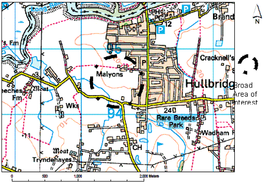
(58) Option SWH1
The site has good access to the town centre and public transport links. The site is bounded to the east and north by residential dwellings and to the west by agricultural fields. The site is adjacent to Lower Road to the south. The condition of existing roads needs to be considered and suitable improvement measures implemented if this site is taken forward. The site will be an extension to Hullbridge and thus not erode away the openness of the Green Belt. The Core Strategy Submission Document requires that the following infrastructure is implemented alongside any development in this location: local highway capacity and infrastructure improvements, public transport infrastructure and service improvements, enhancements and links to pedestrian, cycle and bridle network, and Sustainable Urban Drainage Systems all of which this site has the capacity to provide. The site would afford good opportunities for the creation of a strong defensible green belt boundary.
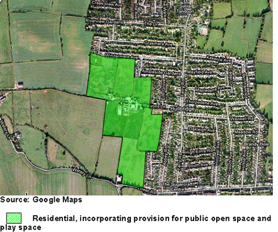
(43) Option SWH2
Option SWH2 is as SWH1 except extends further southwest. This site still provides a defensible boundary but extends the development along Watery Lane, a route that currently suffers from congestion and flooding. The requirements stated within the Core Strategy Submission Document to be implemented alongside a development in this location should provide some mitigation against these issues. The site would afford good opportunities for the creation of a strong defensible green belt boundary.
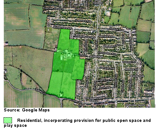
(42) Option SWH3
Option SWH3 is as SWH1 but does not extend as far south as Lower Road, and extends further west. In this way, the dwellings that would be developed to the far west of the site would be much further away from the existing community and the services within Hullbridge, which may not be advisable in terms of community cohesion. The site would afford opportunities for the creation of a defensible green belt boundary.
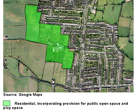
(62) Option SWH4
Option SWH4 is as SWH3 with the addition of the site to the south of Lower Road. The site does not extend as far north as Windermere Avenue, and incorporates Malyons Farm. The two sites in conjunction have the capacity to deliver the housing and infrastructure requirements as specified in the Core Strategy Submission Document. The site would afford opportunities for the creation of a defensible green belt boundary.
(37) Are these sites the most suitable for development in this location?
(14) Should other sites be considered?
(9) Should development be on one site or a selection of sites?
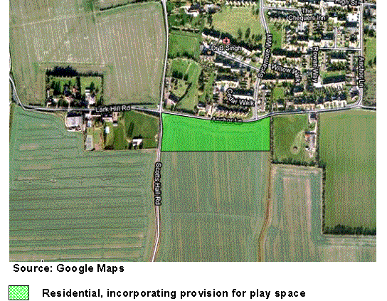
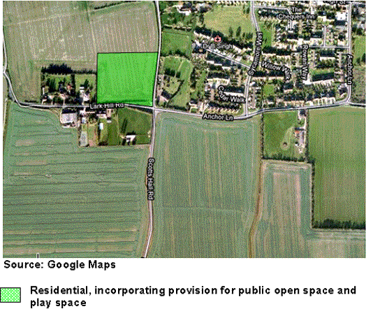
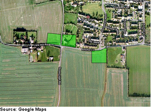
(21) South Canewdon 60 dwellings
Issues;
Allocation required for:
- 60 dwellings
- Play space
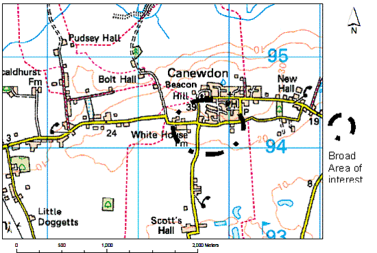
(22) Option SC1
Option SC1 is located south of Anchor Lane and extends as far east as the natural boundary just past the junction with Sycamore Way. The site is bounded to the north and west by roads (Anchor Lane and Scotts Hall Road) to the east by a residential dwelling. To the south of the site are agricultural fields. The Core Strategy Submission Document states that infrastructure required alongside this site includes: local highway capacity and infrastructure improvements, public transport infrastructure and service enhancements, links to and enhancements of pedestrian, cycle and bridleway networks, and Sustainable Urban Drainage Systems, all of which this site has the capacity to provide. Development of 60 dwellings on this site would also help to sustain the rural community whilst not eroding away the openness of the Green Belt. The site would afford opportunities for the creation of a defensible green belt boundary.
(20) Option SC2
Option SC2 is located to the north of Lark Hill Road, at the junction with the road leading to St Nicholas Church. The site is bounded to the west by a residential dwelling, to the south by Lark Hill Road, to the north by agricultural fields and to the east by a road. The site would not erode away the openness of the green belt, and due to its location would add to community cohesion, and not create two distinct communities. It would be difficult to create a defensible green belt boundary if this site were to be developed however.
(28) Option SC3
Option SC3 is as SC2 but the site does not extend so far westwards, and incorporates land to the east of the road leading to St. Nicholas Church. The site is ideally located adjacent to residential settlement, thus enabling community cohesion and maintaining the openness of the green belt. However the impact on the road leading to St Nicholas Church must be considered. It would be difficult to create a defensible green belt boundary from development of these sites however.
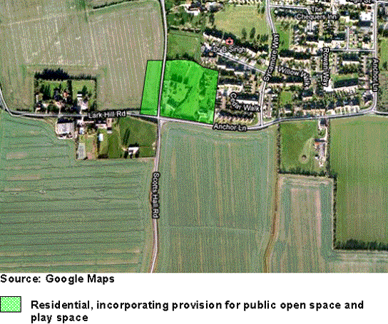
(15) >Option SC4
Option SC4 incorporates aspects from all three of the previous options. The development in this manner however may result in benefits to the community being harder to obtain, and distinct new communities. The development would also be piecemeal, and not provide a defensible green boundary.
(7) Which of these sites is the best location?
(4) Should more sites in the south of Canewdon be considered?
(6) Should development be split between sites or located on one site?
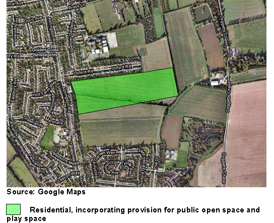
(25) South East Ashingdon 500 dwellings
Issues;
Allocation required for:
- 500 dwellings
- Public Open Space
- Play Space
- Youth and Community Facilities
(3) Option SEA1
The site is currently used as open arable fields. There are a few man made structures and pylons to north and east of the site. The site is bounded to the west by residential development with King Edmund School directly to the south. Access implications to the school need to be considered alongside traffic impacts of new dwellings on roads into and out of the school grounds. The site will however provide a natural defensible boundary to the Green Belt. The Core Strategy Submission Document states that the following infrastructure is required from this site: local highway capacity and infrastructure improvements, contribution to traffic management of Ashingdon Road, public transport infrastructure and service enhancements, links and enhancements to pedestrian, cycling, and bridleway networks, and Sustainable Urban Drainage Systems, all of which the site has the capacity to provide. The location of the site means that it would be unlikely to ensure a robust and defensible Green Belt boundary could be maintained as it does not follow a natural field boundary
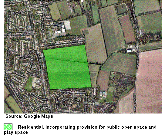
(5) Option SEA2
Option SEA2 is as SEA1 although to the very north of the location, and directly south and east of Oxford Road. The impacts of increased traffic movement on Oxford Road would need to be carefully considered. It would be difficult to create a defensible green belt boundary at this site however.
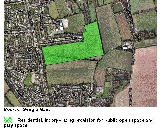
(5) Option SEA3
Option SEA3 is as SEA1 except does not extend as far south and extends further to the east. This however does not provide as strong a defensible green boundary.
(9) Are these the right options for this location?
(3) Should other sites be considered?
(1) Should the development be on site or divided over several sites?
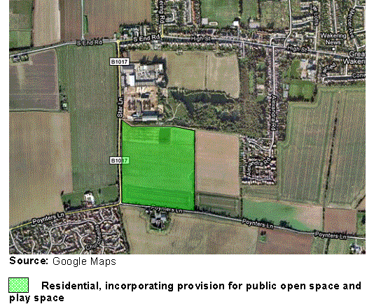
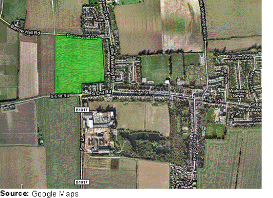
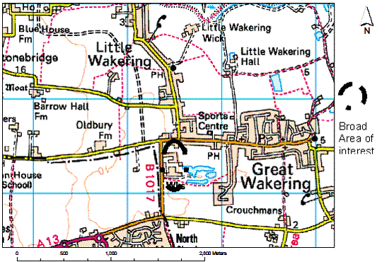
(4) West Great Wakering 250 dwellings
Issues:
Allocation required for:
- 250 dwellings
- Public Open Space
- Play Space
- Youth and Community Facilities
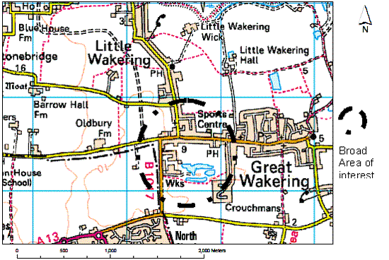
(3) Option WGW1
Option WGW1 is located to the south of High Street, Great Wakering, and east of Star Lane. The land is low lying as a result of previous uses which would need to be considered. North of the site are residential dwellings located on the High Street. To the south west of the site lies Star Lane Industrial Estate, highlighted in the Strategic Housing Land Availability Assessment as being suitable for residential development. The cumulative impacts of the developments would need to be assessed. Infrastructure stated as being required within the Core Strategy Submission Document is as follows: local highway capacity and infrastructure improvements, public transport infrastructure and service improvements, enhancements to pedestrian, cycle and bridleway network, and Sustainable Urban Drainage Systems all of which are deliverable from this site. The location of the site means that it would be unlikely to ensure a robust and defensible Green Belt boundary could be maintained as it does not follow a natural field boundary
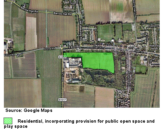
(5) Option WGW2
Option WGW2 is adjacent to residential dwellings at Little Wakering Road and Southend Road, and a development here would as a result promote community cohesion. The sites are also capable of delivering the infrastructure as required. It would be fairly difficult however to provide a defensible green belt boundary to the south of the site.
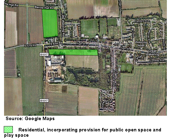
(9) Option WGW3
Option WGW3 includes land to the south of Star Lane, and land to the west of Alexandra Road. This would however create 3 separate communities, although providing the housing and infrastructure required. The site would afford good opportunities for the creation of a strong defensible green belt boundary.
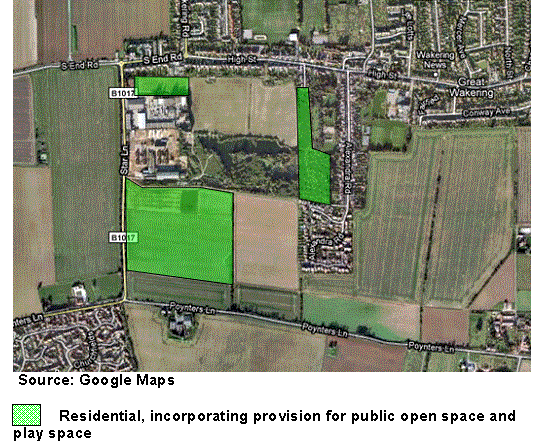
(5) Option WGW4
Option WGW4 encompasses the site to the south of the existing brickworks. This site is however detached from the main settlement of Great Wakering, and is adjacent to the boundary of Southend Borough, increasing the likelihood of coalescence between the two locations. The site would however afford good opportunities for the creation of a strong defensible green belt boundary.
(5) Option WGW5
Option WGW5 is west of Little Wakering Road, and south of Barrow Hall Road. The site is adjacent to the main settlement of Great Wakering, resulting in one community as opposed to two or more distinct communities. The site would however afford good opportunities for the creation of a strong defensible green belt boundary.
(8) Are these the most suitable sites for development?
(3) Should development be located on one site or spread over several sites?
(4) Are there any other sites in this location that should be considered?
(1) Sites recommended in the Strategic Housing Land Availability Assessment
(33) Rawreth Industrial Estate
The site is situated to the south of Rawreth Lane and north of London Road. To the north and south of the site lie residential settlements and to the west lie agricultural fields. The existing building stock is of poor quality and the site has particular environmental issues. Given the sites location within a residential area, the site has excellent accessibility to the highway network and any development will integrate well within the existing community. The site will also provide a defensible green belt boundary.
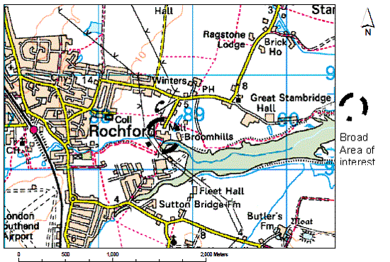
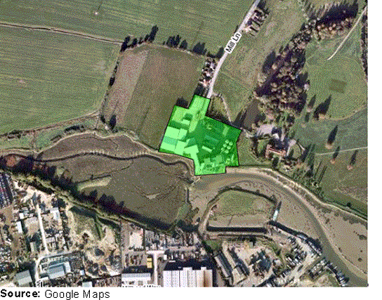
Stambridge Mills
(18) Stambridge Mills is located north of the River Roach, and just south of Stambridge Road. The site is just east of Rochford town centre. The site is surrounded by agricultural fields. It was noted in the Urban Capacity Study that this is a disused brownfield site and is suitable for housing allocation. The site has good access to the highway network and links to Rochford town centre and its associated uses. However this site is located within a flood zone and this must be mitigated against prior to any development. The site would however afford good opportunities for the creation of a strong defensible green belt boundary.
(12) Star Lane Industrial Estate
Star Lane Industrial Estate is located to the east of Great Wakering, south of Southend Road and High Street. The site is currently used for light industrial purposes and is bounded by agricultural land to the west and south. The site is located well with regard to the strategic highway network and the high street of Great Wakering. The quantum of dwellings deliverable from this site could also provide necessary infrastructure enhancements which the community, existing and new, would benefit from. The site is located adjacent to residential development and as such would promote community cohesion. The site would however afford good opportunities for the creation of a strong defensible green belt boundary.
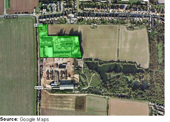
(10) Star Lane Brickworks
Star Lane Brickworks is located to the east of Great Wakering, south of Southend Road and High Street and north of Poynters Lane. The site is also located south of Star Lane Industrial Estate. The site is bounded by agricultural land to the west and south. The site is located well with regard to the strategic highway network and the high street of Great Wakering. The quantum of dwellings deliverable from this site could also provide necessary infrastructure enhancements which the community, existing and new, would benefit from. The site is located adjacent to residential development and as such would promote community cohesion. The site would however afford good opportunities for the creation of a strong defensible green belt boundary.
(2) Housing with the potential to come forward through Area Action Plans
(17) Eldon Way / Foundry Industrial Estate
The site has good road access at a site level and it is adequately serviced for its purpose, however, it has poor strategic access and the quality of existing building stock is very poor. The future of the Eldon Way / Foundry Industrial Estate and any residential capacity coming from the site will be determined through the Hockley Area Action Plan.
(114) Gypsy and Traveller Sites
Rochford District Council must meet the housing needs of all communities, including gypsies and travellers.
The need and demand for Gypsy and Traveller sites in the District has, historically, been very low, especially when compared with other areas of Essex. However, even this low demand has not been met in the past.
The East of England Regional Assembly has prepared a single-issue review on Gypsy and Travellers accommodation that has resulted in the allocation within the East of England Plan of 15 pitches to be provided in Rochford District by 2011, giving a total of 18 pitches for the District. The Annual Monitoring Report 2008-2009 notes that since the publication of the East of England Regional Assembly single-issue review additional pitches have been provided in the District, and there is a need to provide 11 more in order to achieve the required total of 18.
Given the historically low demand within the District, provision for any additional pitches post 2011 will be subject to further review of need.
Gypsy and Traveller Site Allocations
(100) Option GT1
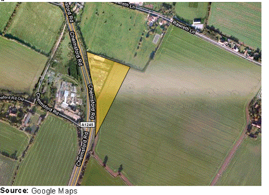
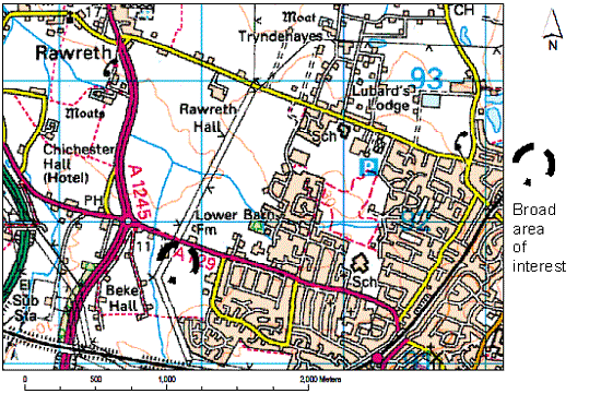
This site is located to the direct east of the A1245 Chelmsford Road, and just south of Rawreth Lane. The settlement of Rawreth is geographically located just north of the site thus providing the ability for the site to relate to other developments. The site is located within good proximity to the highways network, although access to the A1245 would need to be negotiated carefully.
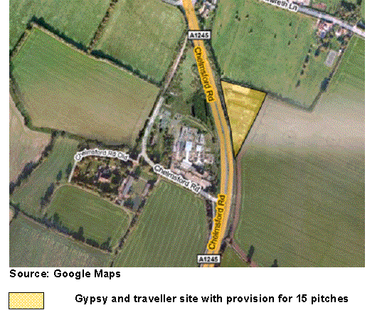
(98) Option GT2
This site is located to the direct east of the A1245 Chelmsford Road, and just south of Rawreth Lane. The settlement of Rawreth is geographically located just north of the site thus providing the ability for the site to relate to other developments. The site is located within good proximity to the highways network, although access to the A1245 would need to be negotiated carefully. This site is as Option GT1, but is larger, enabling the site to support all the required pitches.
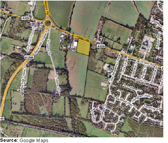
Option GT3
(250) Option GT3 is south of the London Road Rayleigh, and between Little Wheatleys Chase to the east and St Johns Drive to the west. This would offer the potential for increased community cohesion and integration into other settlements. The site is also located with good access to the highway network, and thus good access to services in the town centre. However there are several pylons located within proximity to the site thereby constraining any residential settlement which would need to be accounted for.
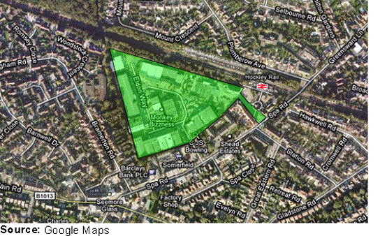
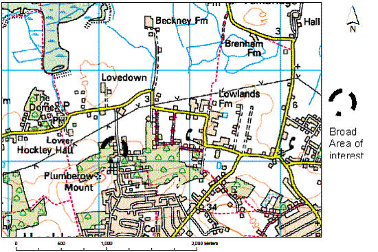
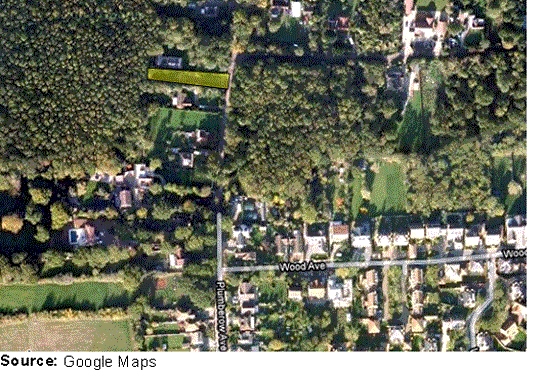
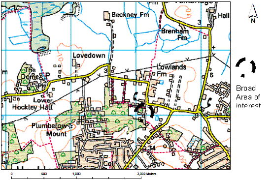
(631) Option GT4
This site is located off Plumberow Avenue in Hockley and is in a residential settlement, with woods to the west of the site. The site is integrated into residential settlement promoting community cohesion. The size of the site may not be appropriate in terms of contributing to the overall gypsy and traveller accommodation target however. There is suitable access to the highways network from this site, with Hockley Rail Station at the southern end of Plumberow Avenue and Spa Road and Main Road just south of this.
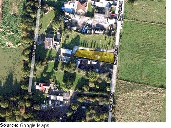
(539) Option GT5
This site is located to the west of New Park Road, and to the south of Cavendish Road in Hockley. The site is likely to be unable to support the full allocation of 15 additional pitches. The site does however integrate well into the existing residential settlement. The site has good access to the highway network.
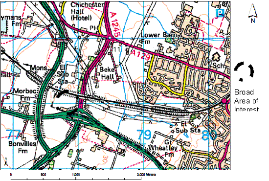
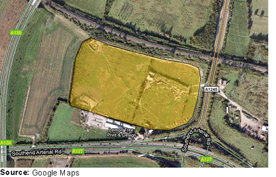
(45) Option GT6
The site is located directly north of the A127 Arterial Road and is west of the A1245. To the west of the site is the A130. Being located in such an area would mean that access to these main routes would need to be negotiated carefully. However the site being located here means that there is excellent access to the strategic highways network. The site is located however some way from any residential settlement which would result in a distinct isolated community and lack of community cohesion. The site would have the capacity to support the full allocation required.
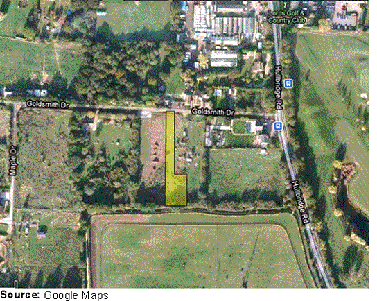
(82) Option GT7
This site is located to the south of Goldsmith Drive, and to the west of Hullbridge Road in Rayleigh. The site is likely to be unable to support the full allocation of 15 additional pitches. The site does however integrate well into the existing residential settlement. The site has fairly good access to the highway network.