Allocations Submission Document
(10) 3. Settlement Extension Residential Land Allocations
Introduction
The Core Strategy adopts a balanced approach to the location of new residential development, and distributes the housing allocation across the District through the identification of nine general locations (Policy H2 and H3):
- North of London Road, Rayleigh
- West Rochford
- West Hockley
- South Hawkwell
- East Ashingdon
- South West Hullbridge
- South Canewdon
- South East Ashingdon
- West Great Wakering
The Core Strategy acknowledges that the housing figures, as required by policy, are minimums and that the actual numbers will be established through this document. The infrastructure and service requirements to accompany the allocation of these sites are detailed within Appendix H1 of the Core Strategy. Concept statements setting out the principles for development of each site are also detailed within this document.
The Core Strategy sets out the approach for the provision of Gypsy and Traveller pitches over the plan period (Policy H7). Whilst there is no national definition of a ‘pitch’, for the purposes of this document it is considered to refer to an individual unit of accommodation within a site that can accommodate approximately one static and one touring caravan. However, as noted within the Essex Gypsy and Traveller Accommodation Needs Assessment (2009), a pitch could contain up to three caravans. A pitch is often a household unit.
Housing Allocations
Between 2006 and 2021 the Council is required to accommodate 3,790 dwellings at an approximate average of 250 dwellings per year. Post 2021, the District is required to continue the development rate of 250 dwellings per year. Accordingly, the Core Strategy sets out the approach to housing distribution to 2025.
The Allocations Document will aid the delivery of the Core Strategy through the allocation of appropriate sites for residential use. The District’s housing supply includes extant permissions and sites already allocated for housing, but additional land needs to be allocated, including appropriate brownfield sites previously allocated for employment use (see chapter 2) and Green Belt land.
The detailed housing supply is set out in the Strategic Housing Land Availability Assessment (SHLAA) 2012 and will be monitored regularly through the Annual Monitoring Reports.
The Core Strategy identified the following approximate quantum of dwellings on Green Belt land (tables in Policy H2 and H3 combined):
Table 2: The approximate quantum of dwellings required on Green Belt land
| Area | Dwellings by 2015 | Dwellings 2015-2021 | Dwellings post 2021 |
|---|---|---|---|
| North of London Road, Rayleigh |
|
||
| West Rochford |
|
|
|
| West Hockley |
|
||
| South Hawkwell |
|
||
| East Ashingdon |
|
||
| South West Hullbridge |
|
|
|
| South Canewdon |
|
||
| South East Ashingdon |
|
||
| West Great Wakering |
|
||
| Total |
|
|
|
The above, whilst phasing the release of Green Belt, facilitates flexibility in the provision of a rolling five year supply of land for housing. The ‘Plan, Monitor, Manage’ approach through the Annual Monitoring Report will monitor and manage land available for housing during the plan period.
It is important that the allocation of land allows for a degree of flexibility in terms of the number of dwellings that can be delivered.
This chapter details policies for settlement extensions to the residential envelope. It sets out the context for each site including on-site constraints and other factors which would need to be considered during development of the site. The minimum dwelling requirement for each location, as per the Core Strategy, plus an allowance of 5% if required, demonstrating the flexibility of the settlement extension as required by national policy is set out.
Alongside a map of the site, a Concept Statement setting out the principles for inclusion and consideration in the development of planning applications are established.
Each site will be required to facilitate the creation of, and demonstrate the defensibility of, the revised Green Belt boundary.
(18) Policy SER1 – North of London Road, Rayleigh
Site Context:
The site is located on agricultural land to the west of Rayleigh. It extends from London Road northwards to Rawreth Lane, and is adjacent to the existing residential area and Rawreth Industrial Estate to the east. There is an increase in the height of the land from London Road towards Rawreth Lane at the northern end of the site, and increase in height of the land from the A1245 eastwards towards Rawreth Industrial Estate.
There are watercourses running through the site from the central area southwards towards London Road and eastwards across the central area of the site towards Grosvenor Road (to the south of Rawreth Industrial Estate), and consequently there is an area of flood zone 2 and 3 running through the site. There is also a foul sewer on site, and pylons currently run north eastwards directly to the west of the site.
There is a Tree Preservation Order area towards the south west corner of the site, and another Tree Preservation Order area adjacent to the site running along the south eastern boundary.
The site is also adjacent to a grade II Listed Building (‘Barn approximately 40 metres east of Rawreth Hall, Rawreth’) which is located just south of Rawreth Lane.
Site Capacity:
The Core Strategy (Policy H2) identifies that the site in this general location should have the capacity to accommodate a minimum of 550 dwellings during the plan period. The site identified in Figure 6 is capable of providing 550 dwellings at a density of 30 dwellings per hectare, plus a flexibility allowance of 5%, if required. The overall site area is 38.8 hectares to take account of site constraints and to accommodate the following infrastructure, services and facilities:
-
New primary school;
-
Local highway capacity and infrastructure improvements;
-
Public transport infrastructure improvements and service enhancements, including a link between Rawreth Lane and London Road;
-
Link and enhancements to local pedestrian/cycling and bridleway network
-
Link to green grid greenway no.13;
-
Public park land to provide a buffer between the built environment and the A1245;
-
Youth and community facilities;
-
Play space; and
-
Sustainable drainage systems.
The principles for the development of this site are set out in the Concept Statement.
Site Map:
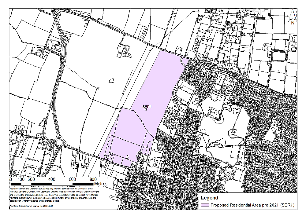
Figure 6: North of London Road, Rayleigh
Concept Statement:
Development of this site should provide 550 dwellings, of which at least 192 should be provided as ‘tenure blind’ affordable housing units. The site will accommodate no more than 550 dwellings, unless it can be demonstrated that:
-
The additional number of dwellings are required to maintain a five year-land supply; and
-
The additional number of dwellings to be provided on the site is required to compensate for a shortfall of dwellings that had been projected to be delivered within the location identified in the adopted Core Strategy.
In any event, the total number of dwellings provided should not exceed 550 by more than 5%.
All dwellings should comply with the Lifetime Homes Standard plus a minimum of 16 dwellings should be built to full wheelchair accessibility standards. A Lifetime Homes and wheelchair accessibility housing statement will be required to accompany any planning application to demonstrate how the proposed development will address the 16 Lifetime Homes Standard design criteria, and show on plans how criteria 1, 3, 5, 6, 7, 10, 12, 14 and 15 will be achieved.
Compliance with the appropriate Code for Sustainable Homes standard will also be required and at least 10% of the energy should be generated by on-site renewable and low carbon sources, unless demonstrated as part of a planning application that this would be unviable.
A minimum area of 1.1 hectares should be set aside for a new primary school on site (Policy EDU1), which should be integrated into the development with good pedestrian and cycling access. A green travel plan will be required to accompany any planning application for the school. The potential for multi-use of the site, accommodating youth and community facilities, should be explored.
The type of youth facilities required to accompany development should reflect the needs of the target age-group. This could take the form of indoor and outdoor facilities, but in any case, a minimum of 0.03 hectares for outdoor youth facilities should be provided, or equivalent area incorporated within other community buildings. The type of youth facilities provided should be determined in consultation with young people and agreed at the planning application stage. Guidance on the provision of outdoor youth facilities produced by Fields in Trust should be referred to.
A minimum of 0.07 hectares for play space should also be provided across the site, although the exact quantum may depend on the type of play space provided. Play space may take the form of a combination of local areas for play (LAP), local equipped areas for play (LEAP) and/or neighbourhood equipped areas for play (NEAP). This should be determined in consultation with the Council, however, for such a development at least a LEAP which requires a minimum of 0.04 hectares should be provided on-site. These areas should be appropriately distributed across the site to enable the local community to easily access them. They should be well located within the development so that they are open, welcoming, safe and easily accessible from pedestrian routes, and within appropriate walking times for the different spaces. Play spaces should be suitably landscaped and visible from nearby dwellings or well used pedestrian routes. In general, the design of these should follow the principles established by Fields in Trust and Play England.
The above calculations of greenspace, play space and youth facilities requirements are based on 550 dwellings being provided on the site. If a greater number are provided, the provision of such facilities should increase proportionately.
At least two vehicular access/egress points onto and off the site for vehicular traffic should be provided from Rawreth Lane and London Road. The site should be configured such that the majority (in the region of two thirds) of dwellings are accessed from London Road. The potential to provide a circular link with one strategic access point and one secondary access point onto London Road should be explored. A bus link will be created between Rawreth Lane and London Road (see Figure 7). However, the road layout within the site will be such that there is no link for private cars between Rawreth Lane and London Road through the site. This could take the form of bus gates, cameras, and/or other forms of engineering to ensure that the relevant section of road is only suitable for buses. This should be determined at the planning application stage in consultation with the relevant bus company and the local highways authority. In addition a Traffic Regulation Order would be required to restrict movement for other road users along this route. However, a link between London Road and Rawreth Lane for all forms of transport may be explored. The route should be such that it would not encourage its use as a ‘through-route’ between Rawreth lane and London Road. The options for this site should be explored in consultation with Essex County Council highways.
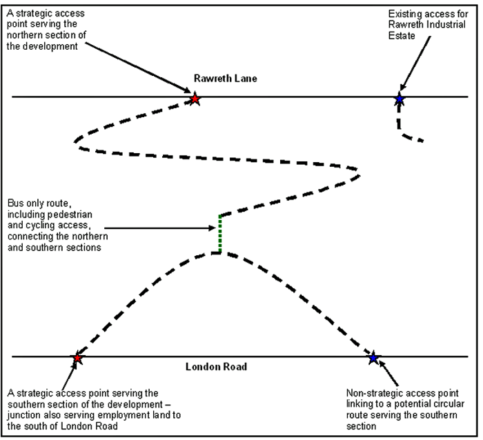
Figure 7: Indicative Diagram of Highway Routes (diagram not to scale)
Pedestrian and cycle routes should be provided throughout the site, ensuring connectivity between the different elements of development, particularly between residential and community uses.
Financial contributions towards local highway capacity and infrastructure improvements, and public transport infrastructure improvements and service enhancements will be required.
A new junction along London Road will be required to serve both the residential area and the employment land to the south of London Road (Policy NEL1). This could take the form of a roundabout or a signalised junction and should be determined at the planning application stage. The new junction on London Road does not necessarily have to be within the area allocated for development. However, any element of the road link that does pass through the Green Belt and green buffer should be well landscaped.
A Transport Impact Assessment, including an assessment of air quality (particularly assessing the potential impact on Rayleigh town centre), must accompany any planning application to develop the site. This must examine the additional transport impacts that the development of this site will generate. Actions to address impacts identified through the Transport Impact Assessment must accompany the development of the site, or be provided prior to the commencement of development.
Financial contributions towards the improvement of road junctions in the vicinity of the development may be required. This should be determined at the planning application stage.
An area of approximately 3.1 hectares is within an area at risk of flooding (flood zone 2 and3) based on the most recent data from the Environment Agency. This area should be set aside for public open space such as natural/semi-natural greenspace.
At least 4 hectares of natural/semi-natural greenspace should be provided (such as woodland).This calculation of need is based on the provision of 550 dwellings across the site. In the event a greater number are provided, the provision should increase proportionately. The majority of this minimum provision must be provided on site within the area at risk of flooding. The rest should be distributed throughout the site.
In addition an area of greenspace should be provided to the west of the site which will act as a buffer between residential development and the A1245. It will not form part of the development area, but will be situated in the Green Belt to the west of the residential settlement. The green buffer should take the form of parkland which is publicly accessible and integrated into the development. Allotments may also be accommodated within the green buffer to the west on an additional 0.3 hectares.
Amenity greenspace/appropriate landscaping should also be integrated into the site.
The playing field to the south of the site along London Road should be relocated. A replacement sports field with new ancillary facilities together with a new club house will be required to be provided ahead of any removal of the existing facility so as to ensure the continued and uninterrupted operation of this valuable community facility. The new structure will be required to be built to the BREEAM (Very good) standard thus providing a new, efficient and environmentally friendly establishment which will be of great advantage to the community as a whole and to the operators of the Sports and Social club. It should be located within the green buffer to the west of the site, although the arrangement of the facility should be such that the clubhouse and associated development are positioned adjacent to the residential settlement to the east and integrated into the development. It is calculated that the new club house will be built within 340 metres of the existing location and will be served by a new road. Additionally this facility should be well connected to the pedestrian and cycling network.
Links and enhancements for walking and cycling and the bridleway network, including the provision of a public footpath along the northern boundary of the site should be developed. The site should also facilitate the development of, and link to, Greenway 13 to the south of London Road, and explore the potential for the development of Greenways through the development. Financial contributions towards the development of Greenway 13 and other non-vehicular routes such as the proposed Sustrans cycle route may also be required.
Existing trees on site, particularly those with Tree Preservations Orders, should be retained, unless it can be demonstrated at the planning application stage that this would render development unviable/undeliverable. The loss of any trees on site or in the vicinity of the site should be appropriately mitigated against, with the provision of replacement trees on a like-for-like basis.
Attenuation Sustainable Drainage Systems (SUDS) of a size proportionate to the development should be used such as balancing ponds, swales, detention basins and green roofs. These could be incorporated into the greenspace provided on- and/or adjacent to the site. Appropriate SUDS should be determined in consultation with Essex County Council. A drainage strategy should be prepared for the site.
There are pylons running north eastwards directly to the west of the site. Whilst the site follows the pylon line along its south western boundary, residential development of this site will be further than 60 metres from these. Siting of the replacement playing field and associated facilities (including car parking) should take into consideration the presence of the pylons. The alignment of the residential boundary in this location is such that, it follows natural features where possible and would facilitate the creation of a multi-use junction for this site and that within Policy NEL1 along London Road.
In relation to the presence of Rawreth Industrial Estate to the east, consideration should be given to the reallocation of this industrial estate. If the site is implemented prior to the redevelopment of Rawreth Industrial Estate (Policy BFR4), provision of a buffer between residential development and industrial uses, whilst ensuring the layout of the residential development will allow future integration with the residential redevelopment of Rawreth Industrial Estate, will be required. If the site is implemented following the redevelopment of Rawreth Industrial Estate for residential use, it should be integrated with the new residential development.
There is a grade II Listed Building (‘Barn approximately 40 metres east of Rawreth Hall, Rawreth’) in close proximity to the site. Development must not adversely impact on the setting of the building, and this must be demonstrated at the planning application stage. A green buffer may be provided to mitigate any potential detrimental impact.
A Health Impact Assessment must be undertaken and accompany any planning applications to develop the site. Actions required to address any negative impacts identified through the Health Impact Assessment must accompany the development of the site.
Small-scale retail (A1) development in the form of neighbourhood shops should be integrated into the development. The number and distribution should be determined at the time of a planning application, having regard to viability.
This site will form a gateway into Rayleigh from the west. The topography of the location will need to be carefully considered at the design stage as there is an increase in the height of the land from London Road towards Rawreth Lane at the northern end of the site, and an increase in the height of the land from the A1245 eastwards towards Rawreth Industrial Estate. A green buffer to the west of the site should have a positive impact on the approach into Rayleigh from this direction. There is an opportunity for the development of landmark buildings towards the western end of the site taking into account the principles of the Essex Design Guide whilst being sensitive to the neighbouring landscape. Design throughout the development should be of high quality.
(7) Policy SER2 – West Rochford
Site Context:
The site is located on agricultural land between Hall Road and Ironwell Lane to the west of Oak Road. Ironwell Lane is an unmade track running from Ashingdon Road in Rochford to Rectory Road in Hawkwell. The site is adjacent to the existing residential area to the east.
The site is just outside the Rochford Conservation Area, which meets the site on its south eastern corner. There are listed structures and buildings in proximity to the site.
There is a small area in the north eastern corner of the site which lies within flood zone 2 and3. There is also a Tree Preservation Order area along the south eastern boundary and other trees subject to Preservation Orders towards the south eastern corner of the site.
There is a public footpath running through the western section of the site northwards from Hall Road to Ironwell Lane, and an existing cycle route runs along Hall Road directly to the south of the site.
Site Capacity:
The Core Strategy (Policy H2) identifies that the site in this general location should have the capacity to accommodate a minimum of 600 dwellings during the plan period. The site identified in Figure 8 is capable of providing 600 dwellings at a density of 30 dwellings per hectare, plus a flexibility allowance of 5%, if required. The overall site area is 28.5 hectares to take account of site constraints and to accommodate the following infrastructure, services and facilities:
- New primary school with commensurate early years and childcare provision;
- Local highway capacity and infrastructure improvements;
- Public transport infrastructure improvements and service enhancements;
- Link and enhancements to local pedestrian/cycling and bridleway network;
- Enhanced pedestrian access to town centre;
- Hall Road junction improvements;
- Sustainable drainage systems;
- Public open space;
- Play space;
- Youth facilities and community facilities; and
- Link to cycle network.
The principles for the development of this site are set out in the Concept Statement.
Site Map:
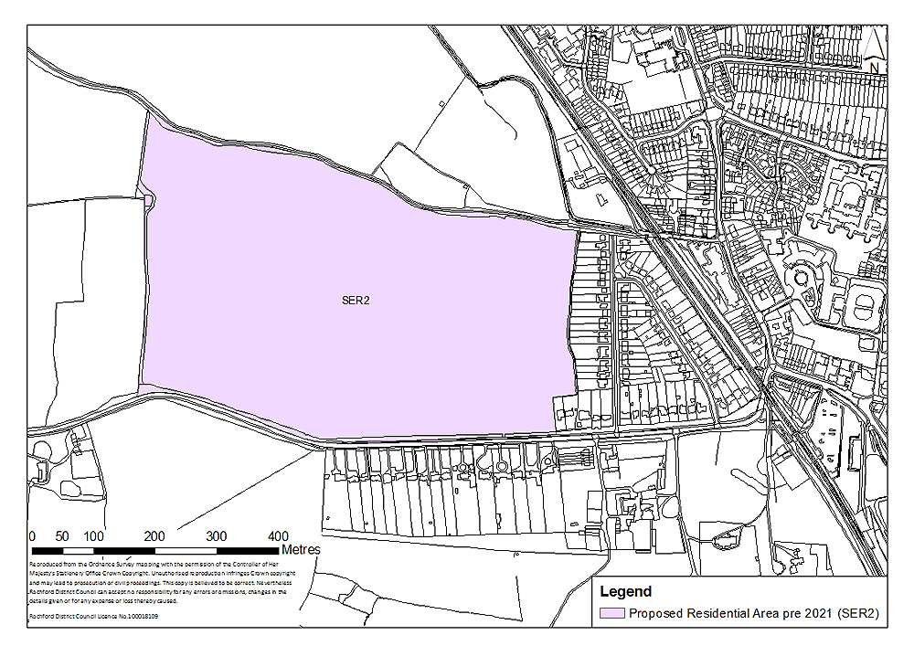
Figure 8: West Rochford
Concept Statement:
Development of this site should provide 600 dwellings, of which at least 210 should be provided as ‘tenure blind’ affordable housing units. The site will accommodate no more than 600 dwellings, unless it can be demonstrated that:
- The additional number of dwellings are required to maintain a five year-land supply; and
- The additional number of dwellings to be provided on the site is required to compensate for a shortfall of dwellings that had been projected to be delivered within the location identified in the adopted Core Strategy.
In any event, the total number of dwellings provided should not exceed 600 by more than 5%.
All dwellings should comply with the Lifetime Homes Standard plus a minimum of 18 dwellings should be built to full wheelchair accessibility standards. A Lifetime Homes and wheelchair accessibility housing statement will be required to accompany any planning application to demonstrate how the proposed development will address the 16 Lifetime Homes Standard design criteria, and show on plans how criteria 1, 3, 5, 6, 7, 10, 12, 14 and 15 will be achieved.
Compliance with the appropriate Code for Sustainable Homes standard will also be required, and a minimum of 10% of the energy should be generated by on-site renewable and low carbon sources, unless demonstrated as part of a planning application that this would be unviable.
Public open space should be provided to the west of the site to act as a buffer between residential development and open land to the west. It will not form part of the development area, but will be situated in the Green Belt to the west of the residential settlement. This area should be a minimum of 4.3 hectares, publically accessible and integrated into the development. Allotments may also be accommodated within the green buffer to the west on an additional 0.3 hectares. This calculation of need is based on 600 dwellings being provided across the site. In the event a greater number are provided, the provision of public open space should increase proportionately.
This site forms the gateway into Rochford and as such a high quality of design is expected. The south side of the site, adjacent to Hall Road, on the approach to the Conservation Area, is sensitive to new development and must be treated accordingly. The frontage should predominantly comprise detached houses, set back from the road frontage, with green landscaping. Fronting the site, hedges should be used to demarcate dwelling boundaries (as opposed to walls or fencing).
Trees and hedges should be developed in garden areas along the eastern boundary of the site to create a green buffer in perpetuity between new and existing development, whilst promoting integration.
Whilst being sensitive to the character and setting of the surrounding area, the development should not be of an overly uniform design. The principles of the Essex Design Guide should be taken into account. The creation of a green buffer will have a positive impact on the western approach along Hall Road into Rochford in particular.
At least 1.1 hectares on site should be set aside for a new primary school with commensurate early years and childcare provision (Policy EDU2). This should be integrated into the development with good pedestrian and cycling access, and the potential for multi-use of the site, accommodating youth and community facilities, should be explored. A green travel plan will be required to accompany any planning application for the school.
The type of youth facilities required to accompany development should reflect the needs of the target age-group. This could take the form of indoor and outdoor facilities, but in any case, a minimum of 0.03 hectares for outdoor youth facilities should be provided, or equivalent area incorporated within other community buildings. The type of youth facilities provided should be determined in consultation with young people and agreed at the planning application stage. Guidance on the provision of outdoor youth facilities produced by Fields in Trust should be referred to.
A minimum of 0.07 hectares for play space should also be provided across the site, although the exact quantum may depend on the type of play space provided. Play space may take the form of a combination of local areas for play (LAP), local equipped areas for play (LEAP) and/or neighbourhood equipped areas for play (NEAP). This should be determined in consultation with the Council, however, for such a development at least a LEAP which requires a minimum of 0.04 hectares should be provided on-site. These areas should be appropriately distributed across the site to enable the local community to easily access them. They should be well located within the development so that they are open, welcoming, safe and easily accessible from pedestrian routes, and within appropriate walking times for the different spaces. Play spaces should be suitably landscaped and visible from nearby dwellings or well used pedestrian routes. In general, the design of these should follow the principles established by Fields in Trust and Play England.
Outdoor sports facilities, such as playing fields, should be provided within the site or off-site, for example through utilising the school playing field, or providing facilities in the adjacent green buffer on a minimum of 2.6 hectares.
The above calculations of greenspace, play space and youth facilities requirements are based on 600 dwellings being provided on the site. If a greater number are provided, the provision of such facilities should increase proportionately.
There is a small area (approximately 0.2 hectares based on the most recent data from the Environment Agency) which is at risk of flooding to the north east corner of the site. This should be designated as public open space such as natural/semi-natural greenspace and integrated into the development.
Amenity greenspace/appropriate landscaping should also be integrated into the site.
There is a Tree Preservation Order area along the south eastern boundary and other trees subject to Preservation Orders towards the south eastern corner of the site which should be retained, unless it can be demonstrated at the planning application stage that this would render development unviable/undeliverable. The loss of any trees on site or in the vicinity of the site should be appropriately mitigated against, with the provision of replacement trees on a like-for-like basis.
The development should be permeable; pedestrian and cycle routes should be provided throughout the site, ensuring connectivity between the different elements of development, particularly between residential and the education/community uses.
Attenuation Sustainable Drainage Systems (SUDS) of a size proportionate to the development should be used such as balancing ponds, swales, detention basins and green roofs. These could be incorporated into the greenspace provided on- and/or adjacent to the site. Appropriate SUDS should be determined in consultation with Essex County Council. A drainage strategy should be prepared for the site.
The wastewater transmission network will need modelling at the planning application stage due to adjacent developments in the same catchment and the downstream transfer pumping station is likely to already be at capacity due to the number of sewer discharge/flood events in close proximity. Any issues identified should be resolved in conjunction with Anglian Water.
Connection from the existing main to the new development area, to be funded by the developer, will be required and upgrades to existing network may be needed. This should be determined in consultation with Essex and Suffolk Water.
A Health Impact Assessment must be undertaken and accompany any planning applications to develop the site. Actions required to address any negative impacts identified through the Health Impact Assessment must accompany the development of the site, or be provided prior to the commencement of development.
At least two vehicular access/egress points and suitable junctions should be provided to the site off Hall Road. Public transport infrastructure improvements and service enhancements in terms of a western bus link to and from the site should be provided. The site should facilitate the development of the proposed Sustrans cycle network particularly along the Ironwell Lane section to the north of the site through financial contributions. A new cycle network within the development should connect the route along Ironwell Lane to the existing cycle network along Hall Road, and provide a non-vehicular route to the Joint Area Action Plan area around London Southend Airport (Policy NEL4). Contributions towards the development of an on-road cycle route along the western end of Hall Road may also be required.
A Transport Impact Assessment, including an assessment of air quality, must accompany any planning application to develop the site. This must examine the additional transport impacts that the development of this site will generate. Actions to address impacts identified through the Transport Impact Assessment must accompany the development of the site, or be provided prior to the commencement of development.
Financial contributions towards local highway capacity and infrastructure improvements will be required, and contributions towards the improvement of road junctions in the vicinity of the development may be required. This should be determined at the planning application stage.
A grade II listed milestone located to the south of the site (‘Milestone on northern verge opposite house called Birches’) and other Listed Buildings (such as the grade I listed ‘Rochford Hall and Ruins’, the adjacent grade II listed wall and barns, and the grade II* listed ‘Church of St Andrews’) would need to be taken into consideration at the planning applications stage. The detailed design and layout of development must ensure there is no adverse impact on the setting of these listed buildings.
(7) Policy SER3 – West Hockley
Site Context:
Folly Lane is located to the south of the site, and Church Road is located to the west. The main part of the site is an area of previously developed land consisting of large buildings, structures and hardstanding. There are existing employment uses on site, and there is existing access onto Folly Lane.
This site also includes greenfield land to the west comprising a wooded area with scrubland on site.
There is a large Tree Preservation Order area adjacent to the site, and there is also a smaller Tree Preservation Order area and several trees subject to Preservation Orders within the curtilage of ‘Windfield’.
Site Capacity:
The Core Strategy (Policy H2) identifies that the site in this general location should have the capacity to accommodate a minimum of 50 dwellings during the plan period. The site identified in Figure 9 is capable of providing 50 dwellings at a density of 30 dwellings per hectare, plus a flexibility allowance of 5%, if required. The overall site area is 2.5 hectares to take account of site constraints and to accommodate the following infrastructure, services and facilities:
-
Local highway capacity and infrastructure improvements;
-
Public transport infrastructure improvements and service enhancements;
-
Link and enhancements to local pedestrian/cycling and bridleway network;
-
Sustainable drainage systems;
-
Public open space;
-
Play space; and
-
Link to cycle network.
The principles for the development of this site are set out in the Concept Statement.
Site Map:
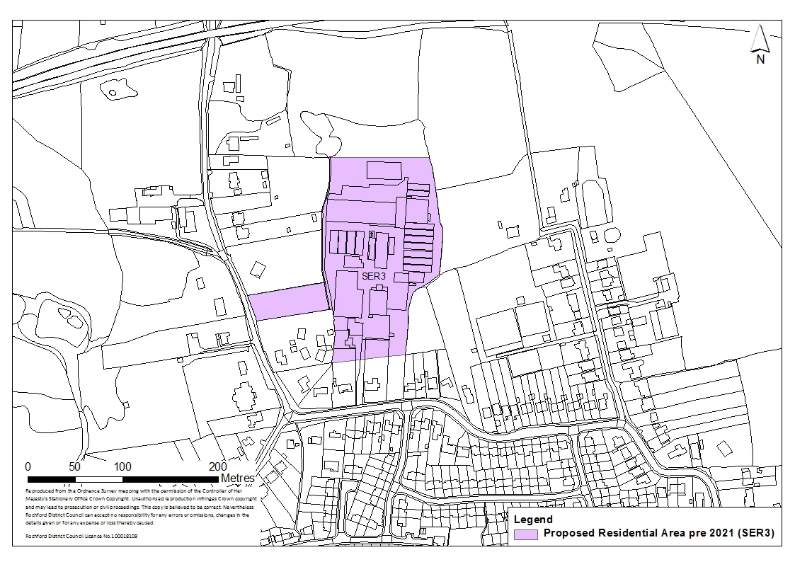
Figure 9: West Hockley
Concept Statement:
Development of this site should provide 50 dwellings, of which at least 17 should be provided as ‘tenure blind’ affordable housing units. The site will accommodate no more than 50 dwellings, unless it can be demonstrated that:
- The additional number of dwellings are required to maintain a five year-land supply; and
- The additional number of dwellings to be provided on the site is required to compensate for a shortfall of dwellings that had been projected to be delivered within the location identified in the adopted Core Strategy.
In any event, the total number of dwellings provided should not exceed 50 by more than 5%.
All dwellings should comply with the Lifetime Homes Standard plus a minimum of one dwelling should be built to full wheelchair accessibility standards. A Lifetime Homes and wheelchair accessibility housing statement will be required to accompany any planning application to demonstrate how the proposed development will address the 16 Lifetime Homes Standard design criteria, and show on plans how criteria 1, 3, 5, 6, 7, 10, 12, 14 and 15 will be achieved.
Compliance with the appropriate Code for Sustainable Homes standard will also be required, and a minimum of 10% of the energy should be generated by on-site renewable and low carbon sources, unless demonstrated as part of a planning application that this would be unviable.
A minimum of 0.4 hectares of amenity greenspace should be integrated into the development, and should be publicly accessible. The provision of other forms of open space such as allotments (a minimum of 0.02 hectares) and outdoor sports facilities (at least 0.2 hectares) could take the form of financial contributions and provided off-site, if it is demonstrated at the planning application stage to be undeliverable on-site.
At least a local area for play (LAP) on a minimum of 0.01 hectares should be provided on the site, but developers should look to provide local equipped areas for play (LEAP) and/or neighbourhood equipped areas for play (NEAP) which require a minimum of 0.04 hectares and 0.1 hectares respectively. These areas should be well located within the development so that they are open, welcoming, safe and easily accessible from pedestrian routes, and within an appropriate walking time. The play spaces should be suitably landscaped and visible from nearby dwellings or well used pedestrian routes. In general, the design of these should follow the principles established by Fields in Trust and Play England.
The type of youth facilities required to accompany development should reflect the needs of the target age-group. This could take the form of indoor and / or outdoor facilities. The type of youth facilities provided should be determined in consultation with young people and agreed at the planning application stage. Guidance on the provision of outdoor youth facilities produced by Fields in Trust should be referred to.
The above calculations of allotments, youth facilities, play space and outdoor sports facilities on 50 dwellings being provided on the site. If a greater number are provided, the provision of such facilities should increase proportionately.
There is a substantial Tree Preservation Order area adjacent to the site to the and west, and there is also a smaller Tree Preservation Order area and several trees subject to Preservation Orders to the west of the site (predominantly within the curtilage of ‘Windfield’). Existing trees in the vicinity, particularly those with a Tree Preservation Order, should be retained unless it can be demonstrated at the planning application stage that this would render development unviable / undeliverable. The loss of any trees on site or in the vicinity of the site should be appropriately mitigated against, with the provision of replacement trees on a like-for-like basis.
An appropriate buffer between the development and the Tree Preservation Order area should be provided.
Trees and hedges should be developed in garden areas along the southern and western boundaries of the site to create a green buffer in perpetuity between new and existing development, whilst promoting integration.
Attenuation Sustainable Drainage Systems (SUDS) of a size proportionate to the development should be used such as balancing ponds, swales, detention basins and green roofs. These could be incorporated into the greenspace provided on-site. Appropriate SUDS should be determined in consultation with Essex County Council. A drainage strategy should be prepared for the site.
The site should provide linkages and enhancements to the local pedestrian/cycling and bridleway network. In particular it should facilitate the development of the proposed Sustrans cycle network particularly along the Church Road and Folly Lane section to the west and south of the site respectively through financial contributions. A cycle route from the site should connect to the Sustrans route along Church Road and Folly Lane.
Existing access/egress on to the site from Folly Lane should be acceptable provided it meets the required highway standards. An existing access/egress point from The Astors onto Church Road should be utilised; an additional access/egress point onto Church Road will not be permitted. This road should link to the north and east of the site.
A Transport Impact Assessment, including an assessment of air quality, must accompany any planning application to develop the site. This must examine the additional transport impacts that the development of this site will generate. Actions to address impacts identified through the Transport Impact Assessment must accompany the development of the site, or be provided prior to the commencement of development.
Financial contributions towards local highway capacity and infrastructure improvements, and public transport infrastructure improvements and service enhancements will be required.
A Health Impact Assessment must be undertaken and accompany any planning applications to develop the site. Actions required to address any negative impacts identified through the Health Impact Assessment must accompany the development of the site, or be provided prior to the commencement of development.
Part of the site is previously developed land and has been in use for a variety of employment activities. A contaminated land study should be undertaken prior to development, and decontamination undertaken as required.
Whilst being sensitive to the character and setting of the surrounding area, the development should not be of an overly uniform design but should be of high quality. The principles of the Essex Design Guide should be taken into account. Appropriate landscaping, particularly along the western boundary given the setting of Church Road, would be required.
(7) Policy SER4 – South Hawkwell
Site Context:
The site comprises a wooded area, a tree nursery, open land in use for grazing, paddocks, a horticultural nursery, open land, a tennis court and a group of buildings in use for business/industrial purposes. It is situated between Rectory Road, Clements Hall Way, Thorpe Road, Thorpe Road Industrial Estate (which is identified in the SHLAA 2012 for residential development) and Spencer’s Park (which is an area of public open space). The site is adjacent to the existing residential area which is designated to the north west and east.
The site is in close proximity to Clements Hall Leisure Centre, and there is an existing public right of way along the northern boundary of the site.
There is a watercourse along the northern boundary, and an area at risk of flooding towards the north east corner of the site (flood zone 2 and 3).
A woodland Tree Preservation Order area is located to the central area of the site. There are also several trees subject to Preservation Orders to the south of the site, just inside the site boundary and another tree with a Preservation Order to the north west corner.
There is a grade II Listed Building (‘The Old Rectory, Rectory Road’) in proximity to the site to the south.
Site Capacity:
The Core Strategy (Policy H2) identifies that the site in this general location should have the capacity to accommodate a minimum of 175 dwellings during the plan period. The site identified in Figure 10 is capable of providing 175 dwellings at a density of 30 dwellings per hectare, plus a flexibility allowance of 5%, if required. The overall site area is 11.2 hectares to take account of site constraints and to accommodate the following infrastructure, services and facilities:
- Local highway capacity and infrastructure improvements;
- Public transport infrastructure improvements and service enhancements;
- Link and enhancements to local pedestrian/cycling and bridleway network;
- Sustainable drainage systems;
- Play space;
- Link to cycle network; and
- Local highway improvements
The principles for the development of this site are set out in the Concept Statement.
Site Map:
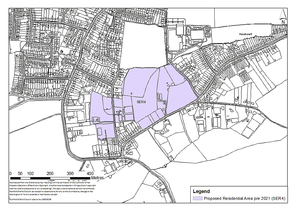
Figure 10: South Hawkwell
Concept Statement:
Development of this site should provide 175 dwellings, of which at least 61 should be provided as ‘tenure blind’ affordable housing units. The site will accommodate no more than 175 dwellings, unless it can be demonstrated that:
- The additional number of dwellings are required to maintain a five year-land supply; and
- The additional number of dwellings to be provided on the site is required to compensate for a shortfall of dwellings that had been projected to be delivered within the location identified in the adopted Core Strategy.
In any event, the total number of dwellings provided should not exceed 175 by more than 5%.
All dwellings should comply with the Lifetime Homes Standard plus a minimum of five dwellings should be built to full wheelchair accessibility standards. A Lifetime Homes and wheelchair accessibility housing statement will be required to accompany any planning application to demonstrate how the proposed development will address the 16 Lifetime Homes Standard design criteria, and show on plans how criteria 1, 3, 5, 6, 7, 10, 12, 14 and 15 will be achieved.
Compliance with the appropriate Code for Sustainable Homes standard will also be required, and a minimum of 10% of the energy should be generated by on-site renewable and low carbon sources, unless demonstrated as part of a planning application that this would be unviable.
There is a watercourse along the northern boundary of the site and an area at risk of flooding to the north east corner (approximately 0.5 hectares which is based on the most recent data from the Environment Agency). This area should be designated as public open space. Pedestrian and cycling links should also be provided to enhance connectivity between the site and the area of public open space to the north (Spencer’s Park).
There is a Woodland Tree Preservation Order area towards the central area of the site and other trees subject to Preservation Orders on site which should be retained. The paddocks along Rectory Road and other existing trees along the boundary of the site should also be retained to preserve the setting of Rectory Road in this location. The loss of any trees on site or in the vicinity of the site should be appropriately mitigated against, with the provision of replacement trees on a like-for-like basis.
Trees and hedges should be developed in garden areas along the boundaries of the site to create a green buffer in perpetuity between new and existing development, whilst promoting integration.
Whilst being sensitive to the character and setting of the surrounding area, the development should not be of an overly uniform design but should be of high quality. The principles of the Essex Design Guide should be taken into account. Amenity greenspace/appropriate landscaping should be provided on-site.
At least a local area for play (LAP) on a minimum of 0.02 hectares should be provided on the site, but developers should look to provide local equipped areas for play (LEAP) and/or neighbourhood equipped areas for play (NEAP) which require a minimum of 0.04 hectares and 0.1 hectares respectively. These areas should be well located within the development so that they are open, welcoming, safe and easily accessible from pedestrian routes, and within an appropriate walking time. The play spaces should be suitably landscaped and visible from nearby dwellings or well used pedestrian routes. In general, the design of these should follow the principles established by Fields in Trust and Play England.
The provision of outdoor youth facilities should be considered. The type of youth facilities required to accompany development should reflect the needs of the target age-group. This could take the form of indoor and / or outdoor facilities but in any case, a minimum of 0.01 hectares for outdoor youth facilities should be provided. The type of youth facilities provided should be determined in consultation with young people and agreed at the planning application stage. Guidance on the provision of outdoor youth facilities produced by Fields in Trust should be referred to.
The above calculations of play space and youth facilities requirements are based on 175 dwellings being provided on the site. If a greater number are provided, the provision of such facilities should increase proportionately.
Development of this site should enable integration with the site allocated for residential development to the west (Thorpe Road Industrial Estate). Should this site not come forward for development in a timely manner, then a green buffer may be needed to mitigate any potential impact of the employment site on residential amenity. However, this should not restrict future integration of the two sites.
The site should provide linkages and enhancements to the local pedestrian/cycling and bridleway network. In particular it should facilitate the development of the proposed Sustrans cycle network, particularly along the Mount Bovers Lane, Thorpe Road, Clements Hall Way and Ironwell Lane section to the west and, north and south east of the site through financial contributions.
A Transport Impact Assessment, including an assessment of air quality, must accompany any planning application to develop the site. This must examine the additional transport impacts that the development of this site will generate. Actions to address impacts identified through the Transport Impact Assessment must accompany the development of the site, or be provided prior to the commencement of development.
Appropriate access/egress onto the site from the highway network would be required. Local highway capacity and infrastructure improvements, and public transport infrastructure improvements and service enhancements would be required. Links and enhancements to the local pedestrian/cycling and bridleway network should also be provided.
In terms of wastewater transmission, the network should be modelled to assess capacity as there are numerous sewer flooding events on the downstream network within Rochford, which could be exacerbated by development of the site. Any issues identified should be resolved in conjunction with Anglian Water.
Connection from the existing main to the new development area, to be funded by the developer, will be required and upgrades to existing network may be needed. This should be determined in consultation with Essex and Suffolk Water.
There is a high pressure gas pipe line with easement on-site which should be moved prior to development on the site as appropriate.
A contaminated land study should be undertaken prior to development, and decontamination undertaken as required.
The potential impact on a nearby grade II Listed Building (’The Old Rectory, Rectory Road, Hawkwell’) would need to be taken into consideration at the planning applications stage. The detailed design and layout of development must ensure there is no adverse impact on the setting of this listed building.
Attenuation Sustainable Drainage Systems (SUDS) of a size proportionate to the development should be used such as balancing ponds, swales, detention basins and green roofs. These could be incorporated into the greenspace provided on-site. Appropriate SUDS should be determined in consultation with Essex County Council. A drainage strategy should be prepared for the site.
A Health Impact Assessment must be undertaken and accompany any planning applications to develop the site. Actions required to address any negative impacts identified through the Health Impact Assessment must accompany the development of the site, or be provided prior to the commencement of development.
(5) Policy SER5 – East Ashingdon
Site Context:
The site is situated to the south of Brays Lane and to the east of Spencer Gardens. Grazing land occupies the central and western section of the site, and stables, hardstanding and outbuildings are located towards the eastern section.
The site is adjacent to the existing residential area to the west and King Edmund School borders the site to the south.
There are 10 trees subject to Preservation Orders along the southern, eastern and western boundaries of the site.
Site Capacity:
The Core Strategy (Policy H2) identifies that the site in this general location should have the capacity to accommodate a minimum of 100 dwellings during the plan period. The site identified in Figure 11 is capable of providing 100 dwellings at a density of 30 dwellings per hectare, plus a flexibility allowance of 5%, if required. The overall site area is 5.5 hectares to take account of site constraints and to accommodate the following infrastructure, services and facilities:
- Local highway capacity and infrastructure improvements;
- Public transport infrastructure improvements and service enhancements;
- Link and enhancements to local pedestrian/cycling and bridleway network;
- Access to King Edmund School;
- Land made available for the expansion of King Edmund School;
- Sustainable drainage systems;
- Public open space;
- Play space; and
- Youth facilities and community facilities.
Development of this site would not be able to accommodate some of the infrastructure requirements such as youth and community facilities. It is likely to be more viable to provide such facilities off-site.
The principles for the development of this site are set out in the Concept Statement.
Site Map:
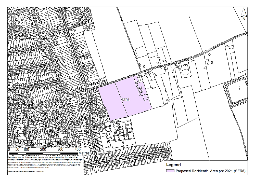
Figure 11: East Ashingdon
Concept Statement:
Development of this site should provide 100 dwellings, of which at least 35 should be provided as ‘tenure blind’ affordable housing units. The site will accommodate no more than 100 dwellings, unless it can be demonstrated that:
- The additional number of dwellings are required to maintain a five year-land supply; and
- The additional number of dwellings to be provided on the site is required to compensate for a shortfall of dwellings that had been projected to be delivered within the location identified in the adopted Core Strategy.
In any event, the total number of dwellings provided should not exceed 100 by more than 5%.
All dwellings should comply with the Lifetime Homes Standard plus a minimum of three dwellings should be built to full wheelchair accessibility standards. A Lifetime Homes and wheelchair accessibility housing statement will be required to accompany any planning application to demonstrate how the proposed development will address the 16 Lifetime Homes Standard design criteria, and show on plans how criteria 1, 3, 5, 6, 7, 10, 12, 14 and 15 will be achieved.
Compliance with the appropriate Code for Sustainable Homes standard will also be required, and a minimum of 10% of the energy should be generated by on-site renewable and low carbon sources, unless demonstrated as part of a planning application that this would be unviable.
Improved access/egress to King Edmund School should be provided through this site from Brays Lane. Local highway capacity and infrastructure improvements and public transport infrastructure improvements and service enhancements should also be provided.
Links and enhancements to the local pedestrian/cycling and bridleway network should be provided. A modal shift to reduce use of private vehicles and to encourage walking and cycling is particularly important in this location.
A Transport Impact Assessment, including an assessment of air quality, must accompany any planning application to develop the site. This must examine the additional transport impacts that the development of this site will generate. Actions to address impacts identified through the Transport Impact Assessment must accompany the development of the site, or be provided prior to the commencement of development.
At least 0.7 hectares of natural/semi-natural greenspace which is publicly accessible should be provided on-site and integrated into the development. At least a local area for play (LAP) on a minimum of 0.02 hectares should be provided on the site, but developers should look to provide local equipped areas for play (LEAP) and/or neighbourhood equipped areas for play (NEAP) which require a minimum of 0.04 hectares and 0.1 hectares respectively. These areas should be well located within the development so that they are open, welcoming, safe and easily accessible from pedestrian routes, and within an appropriate walking time. The play spaces should be suitably landscaped and visible from nearby dwellings or well used pedestrian routes. In general, the design of these should follow the principles established by Fields in Trust and Play England.
The provision of youth facilities and community facilities should, if demonstrated to be undeliverable on-site at the planning application stage, be provided in proximity to the site on land identified within Policy SER8. Proportionate financial contributions towards this provision should be made. The type of youth facilities required to accompany development should reflect the needs of the target age-group. This could take the form of indoor and / or outdoor facilities. The type of youth facilities provided should be determined in consultation with young people and agreed at the planning application stage. Guidance on the provision of outdoor youth facilities produced by Fields in Trust should be referred to.
Allotments (a minimum of 0.05 hectares) for this should be provided within Policy SER8, and contributions made accordingly.
The above calculations of greenspace, allotments, play space and youth facilities requirements are based on 100 dwellings being provided on the site. If a greater number are provided, the provision of such facilities should increase proportionately.
The trees subject to Preservation Orders along the southern, eastern and western boundaries of the site should be retained, unless it can be demonstrated at the planning application stage that this would render development unviable/undeliverable. The loss of any trees on site or in the vicinity of the site, particularly those with Tree Preservation Orders, should be appropriately mitigated against, with the provision of replacement trees on a like-for-like basis. Trees and hedges should be developed in garden areas along the eastern, southern and western boundaries of the site to create a green buffer in perpetuity between new and existing development, whilst promoting integration.
Amenity greenspace/appropriate landscaping should be provided on-site. Whilst being sensitive to the character and setting of the surrounding area, the development should not be of an overly uniform design but should be of high quality. The principles of the Essex Design Guide should be taken into account.
Land should be made available for the expansion of King Edmund School off-site in this broad location (see Policy EDU3).
Attenuation Sustainable Drainage Systems (SUDS) of a size proportionate to the development should be used such as balancing ponds, swales, detention basins and green roofs. These could be incorporated into the greenspace provided on-site. Appropriate SUDS should be determined in consultation with Essex County Council. A drainage strategy should be prepared for the site.
In terms of wastewater transmission, the network should be modelled to assess capacity as there are numerous sewer flooding events on the downstream network within Rochford, which could be exacerbated by development of the site. Any issues identified should be resolved in conjunction with Anglian Water.
Connection from the existing main to the new development area, to be funded by the developer, will be required and upgrades to existing network may be needed. This should be determined in consultation with Essex and Suffolk Water.
A Health Impact Assessment must be undertaken and accompany any planning applications to develop the site. Actions required to address any negative impacts identified through the Health Impact Assessment must accompany the development of the site, or be provided prior to the commencement of development.
(191) Policy SER6 – South West Hullbridge
Site Context:
The site extends northwards from Lower Road to West Avenue/Windermere Avenue and is adjacent to the existing residential area which is designated to the north and east.
It is agricultural land with several large agricultural buildings and three dwellings on site. There is an increase in the height of the land northwards from Lower Road.
There are trees subject to Preservation Orders towards the northern boundary of the site to the south of West Avenue/Windermere Avenue. There is also a telecommunications mast on site.
Site Capacity:
The Core Strategy (Policy H2 and H3) identifies that the site in this general location should have the capacity to accommodate a minimum of 500 dwellings during the plan period. The site identified in Figure 12 is capable of providing 500 dwellings at a density of 30 dwellings per hectare, plus a flexibility allowance of 5%, if required. The overall site area is 23.4 hectares to take account of site constraints and to accommodate the following infrastructure, services and facilities:
- Local highway capacity and infrastructure improvements, including improvements to Watery Lane and Watery Lane/Hullbridge Road junction;
- Public transport infrastructure improvements and service enhancements;
- Link and enhancements to local pedestrian/cycling and bridleway network;
- Sustainable drainage systems;
- Public open space;
- Play space;
- Youth facilities and community facilities;
- Leisure facilities; and
- Link to cycle network.
Part of the site (SER6a) shown on Figure 12 will be allocated for residential development from adoption of the Allocations Document. The area identified as SER6b will be safeguarded from development until 2021, unless required in order to maintain a five-year supply of deliverable housing land.
The first phase shown as SER6a is 13.6 hectares in area, which is larger than the second phase - SER6b (9.8 hectares). This would enable the first phase to accommodate facilities, open space, etc. to accompany the development as a whole. As such, the developable area for residential development on SER6a is likely to be nearer 50%.
The principles for the development of this site are set out in the Concept Statement.
Site Map:
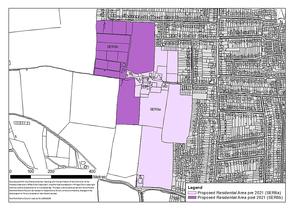
Figure 12: South west Hullbridge
Concept Statement:
Development of this site should provide 500 dwellings, of which at least 175 should be provided as ‘tenure blind’ affordable housing units. The site will accommodate no more than 500 dwellings, unless it can be demonstrated that:
- The additional number of dwellings are required to maintain a five year-land supply; and
- The additional number of dwellings to be provided on the site is required to compensate for a shortfall of dwellings that had been projected to be delivered within the location identified in the adopted Core Strategy.
In any event, the total number of dwellings provided should not exceed 500 by more than 5%.
The area identified as SER6b will also be safeguarded until post-2021 unless it can be demonstrated that it is required to be brought forward to contribute towards the District’s five-year housing supply.
All dwellings should comply with the Lifetime Homes Standard plus a minimum of 15 dwellings should be built to full wheelchair accessibility standards. A Lifetime Homes and wheelchair accessibility housing statement will be required to accompany any planning application to demonstrate how the proposed development will address the 16 Lifetime Homes Standard design criteria, and show on plans how criteria 1, 3, 5, 6, 7, 10, 12, 14 and 15 will be achieved.
Compliance with the appropriate Code for Sustainable Homes standard will also be required and at least 10% of the energy should be generated by on-site renewable and low carbon sources, unless demonstrated as part of a planning application that this would be unviable.
A minimum of 3.6 hectares of the site should accommodate publicly accessible natural/semi-natural greenspace. This should be well-integrated into the development, and accessible for residents of both phases of development.
Trees and hedges should be developed in garden areas along the northern, eastern and southern boundaries of the site in both phases, as appropriate, to create a green buffer in perpetuity between new and existing development, whilst promoting integration. Amenity greenspace (at least 0.4 hectares) should also be integrated into the development.
Play space, on a minimum of 0.06 hectares, should also be provided, although the exact quantum may depend on the type of play space provided. Play space may take the form of a combination of local areas for play (LAP), local equipped areas for play (LEAP) and/or neighbourhood equipped areas for play (NEAP). This should be determined in consultation with the Council, however, for such a development at least a LEAP which requires a minimum of 0.04 hectares should be provided on-site. These areas should be primarily be provided during the first phase of development (Policy SER6a) and, where necessary, during the second phase (Policy SER6b). They should be appropriately distributed across the site to enable the local community to easily access them. They should be well located within the development so that it is open, welcoming, safe and easily accessible from pedestrian routes, and within an appropriate walking time. The play spaces should be suitably landscaped and visible from nearby dwellings or well used pedestrian routes. In general, the design of this should follow the principles established by Fields in Trust and Play England.
There are trees subject to Preservation Orders to the south of West Avenue/Windermere Avenue which should be retained, unless it can be demonstrated at the planning application stage that this would render development unviable/undeliverable. The loss of any trees on site or in the vicinity of the site should be appropriately mitigated against, with the provision of replacement trees on a like-for-like basis.
Youth, community and leisure facilities should be provided within the first phase of the development (Policy SER6a) and should be well-integrated into this phase and enable integration with the second phase of development (Policy SER9b) to ensure that facilities are accessible to the community.
The type of community facilities provided on the site should meet local need and should be determined in consultation with the Council at the planning application stage.
The type of youth facilities required to accompany development should reflect the needs of the target age-group. This could take the form of indoor and outdoor facilities but in any case, a minimum of 0.02 hectares for outdoor youth facilities should be provided. The type of youth facilities provided should be determined in consultation with young people and agreed at the planning application stage. Guidance on the provision of outdoor youth facilities produced by Fields in Trust should be referred to. The potential to provide a new skate park on-site and upgrade the existing skate park at Pooles Lane playing field should be explored.
The provision of leisure facilities should be determined in consultation with the Council at the planning application stage. They should be accessible to the community and meet local needs.
The above calculations of greenspace, play space and youth facilities requirements are based on 500 dwellings being provided on the site. If a greater number are provided, the provision of such facilities should increase proportionately.
Small-scale retail (A1) development in the form of neighbourhood shops should be integrated into the development, primarily during the first phase of development (Policy SER6a). The number and distribution should be determined at the time of a planning application, having regard to viability.
A Transport Impact Assessment, including an assessment of air quality, must accompany any planning application to develop the site. This must examine the additional transport impacts that the development of this site will generate. Actions to address impacts identified through the Transport Impact Assessment must accompany the development of the site, or be provided prior to the commencement of development. In particular, the development of this site should contribute towards improvements to the highway network to facilitate movement along the western part of the network.
Alongside the first phase of development (Policy SER6a), local highway capacity and infrastructure improvements, including improvements to Watery Lane and Watery Lane/Hullbridge Road junction should be made. Further appropriate improvements should be made to accompany the second phase (Policy SER6b) where necessary.
Financial contributions towards local highway capacity and infrastructure improvements, and public transport infrastructure improvements and service enhancements will be required.
Pedestrian and cycle routes should be provided throughout the site, ensuring connectivity between the different elements of development, particularly between residential and the community uses in the first phase (Policy SER6a). These non-vehicular routes should also link to, and be provided throughout, the second phase of development (Policy SER6b).
The site should facilitate links and enhancements to the local pedestrian/cycling and bridleway network; these links should accompany both phases of development. In particular the site should facilitate the development of the proposed Sustrans cycle network along the Watery Lane and Lower Road section to the south of the site through financial contributions.
Existing road links to the east should predominantly provide pedestrian and cycling access to the centre of the village. At least two access/egress points onto the site should be provided, one to the south connecting the development to Lower Road and one to the east providing access onto Ferry Road (preferably Malyons Lane).
Localised surface water flooding along Watery Lane to the south west of the site is an existing issue which development in this location should account for through the provision of Sustainable Drainage Systems (SUDS). Attenuation SUDS of a size proportionate to the development should be used such as balancing ponds, swales, detention basins and green roofs. These could be incorporated into the greenspace provided on-site. Appropriate SUDS should be determined in consultation with Essex County Council. A drainage strategy should be prepared for the site.
In terms of wastewater transmission, an upgrade to the Rayleigh Waste Water Treatment Works is likely to be required prior to development. Any issues identified should be resolved in conjunction with Anglian Water.
Connection from the existing main to the new development area, to be funded by the developer, will be required and upgrades to existing network may be needed. This should be determined in consultation with Essex and Suffolk Water.
A Health Impact Assessment must be undertaken and accompany any planning applications to develop the site. Actions required to address any negative impacts identified through the Health Impact Assessment must accompany the development of the site, or be provided prior to the commencement of development.
The topography of the site needs to be carefully considered at the planning application stage. There is an increase in the height of the land northwards from Lower Road, which would need to be taken into consideration in terms of design and visual impact of the site. A harsh demarcation of the Green Belt boundary to the west of the site should be avoided and appropriate landscaping should be implemented along the western boundary. Whilst being sensitive to the character and setting of the surrounding area, the development should not be of an overly uniform design but should be of high quality. The principles of the Essex Design Guide should be taken into account.
(74) Policy SER7 – South Canewdon
Site Context:
This site identifies two areas to the east and west of the lane providing access to Canewdon Hall Farm and St Nicholas Church. It is predominantly greenfield land with some previously developed land to the north of Anchor Lane and Lark Hill Road, and is located adjacent to the existing residential area along its eastern boundary.
The Canewdon Church Conservation Area abuts the site along its north eastern boundary.
There are two entrances to the eastern part of the site providing access to two existing dwellings from Anchor Lane. It is bounded by roads to the south and west, residential development to the east and greenfield land to the north (where the Conservation Area begins).
The area to the west of the lane is bounded by roads to the east and south, dwellings to the west and greenfield land to the north.
The topography is sensitive in this location as the land increases in height northwards from Anchor Lane and Lark Hill Road.
There are existing trees and hedgerows predominantly fronting the highways.
Site Capacity:
The Core Strategy (Policy H2) identifies that the site in this general location should have the capacity to accommodate a minimum of 60 dwellings during the plan period. The site identified in Figure 13 is capable of providing 60 dwellings at a density of 30 dwellings per hectare, plus a flexibility allowance of 5%, if required. The overall site area is 2.4 hectares to take account of site constraints and to accommodate the following infrastructure, services and facilities:
- Local highway capacity and infrastructure improvements;
- Public transport infrastructure improvements and service enhancements;
- Link and enhancements to local pedestrian/cycling and bridleway network;
- Sustainable drainage systems; and
- Play space.
The principles for the development of this site are set out in the Concept Statement.
Site Map:
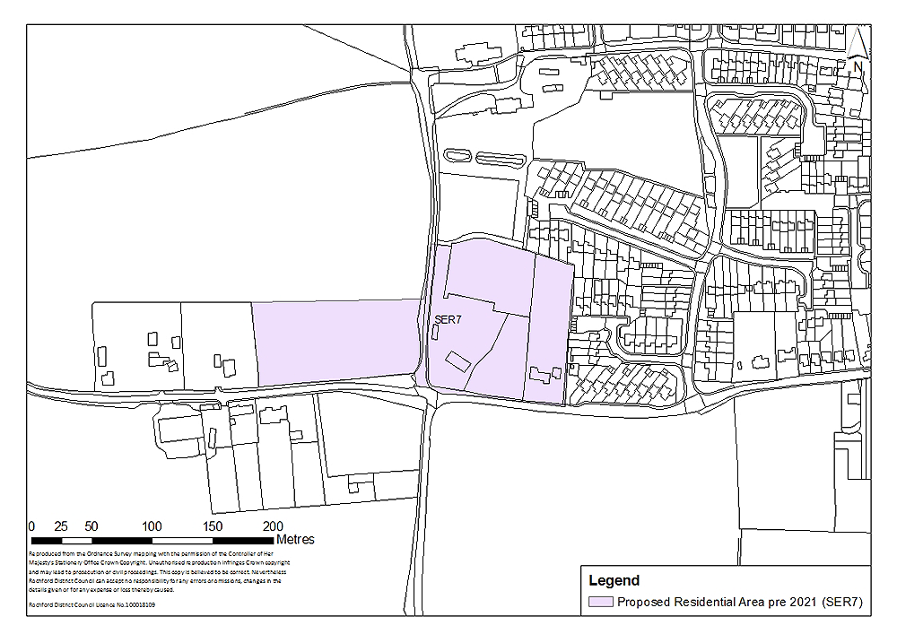
Figure 13: South Canewdon
Concept Statement:
Development of this site should provide 60 dwellings, of which at least 21 should be provided as ‘tenure blind’ affordable housing units. The site will accommodate no more than 60 dwellings, unless it can be demonstrated that:
- The additional number of dwellings are required to maintain a five year-land supply; and
- The additional number of dwellings to be provided on the site is required to compensate for a shortfall of dwellings that had been projected to be delivered within the location identified in the adopted Core Strategy.
In any event, the total number of dwellings provided should not exceed 60 by more than 5%.
All dwellings should comply with the Lifetime Homes Standard plus a minimum of one dwelling should be built to full wheelchair accessibility standards. A Lifetime Homes and wheelchair accessibility housing statement will be required to accompany any planning application to demonstrate how the proposed development will address the 16 Lifetime Homes Standard design criteria, and show on plans how criteria 1, 3, 5, 6, 7, 10, 12, 14 and 15 will be achieved.
Compliance with the appropriate Code for Sustainable Homes standard will also be required, and a minimum of 10% of the energy should be generated by on-site renewable and low carbon sources, unless demonstrated as part of a planning application that this would be unviable.
The topography in this location would need to be sensitively and carefully considered in the design and landscaping of the development due to the visual impact resulting from the increase in the height of the land northwards from Anchor Lane and Lark Hill Road. An area of open space (a minimum of 0.4 hectares of natural/semi-natural greenspace) should be provided to the north of the site, west of the lane. This green buffer will not form part of the development area, but will be situated in the Green Belt to the north/north west of the residential settlement. It should take the form of parkland which is publicly accessible and integrated into the development.
Development must be sensitive to views of St Nicholas Church particularly from the south west.
Lower density towards the western section of the site may be appropriate, given the sensitive topography; development in this location should be well landscaped as well as sensitive to the neighbouring properties.
Trees and hedges should be developed in garden areas along the northern, western and southern boundaries of the site to create a green buffer in perpetuity between new and existing development, whilst promoting integration.
The loss of any trees on site or in the vicinity of the site should be appropriately mitigated against, with the provision of replacement trees on a like-for-like basis.
Amenity greenspace/appropriate landscaping should be provided throughout the site. Whilst being sensitive to the character and setting of the surrounding area, the development should not be of an overly uniform design but should be of high quality. The principles of the Essex Design Guide should be taken into account.
Despite the presence of an existing road running through this site, development should ensure integration of both sections of the site.
The development should also be appropriately designed and landscaped taking into consideration the Canewdon Church Conservation Area to the north/north east of the site. Listed Buildings in proximity to the site, in particular the grade II* listed ‘Church of St Nicholas, High Street, Canewdon’ and grade II listed ‘The Vicarage, High Street, Canewdon’ located to the north/north east of the site, and the grade II listed ‘White House Farmhouse, Lark Hill Road, Canewdon’ would need to be taken into consideration at the planning application stage. The detailed design and layout of development must ensure there is no adverse impact on the setting of these listed buildings.
At least a local area for play (LAP) on a minimum of 0.01 hectares should be provided on the site, but developers should look to provide local equipped areas for play (LEAP) and/or neighbourhood equipped areas for play (NEAP) which require a minimum of 0.04 hectares and 0.1 hectares respectively. These areas should be well located within the development so that they are open, welcoming, safe and easily accessible from pedestrian routes, and within an appropriate walking time. The play spaces should be suitably landscaped and visible from nearby dwellings or well used pedestrian routes. In general, the design of these should follow the principles established by Fields in Trust and Play England.
The above calculations of greenspace and play space requirements are based on 60 dwellings being provided on the site. If a greater number are provided, the provision of such facilities should increase proportionately.
Financial contributions towards local highway capacity and infrastructure improvements, and public transport infrastructure improvements and service enhancements will be required.
Links and enhancements to local pedestrian/cycling and bridleway network, particularly as there is no footpath to the south of the site along Lark Hill Road and Anchor Lane, will be required.
A Transport Impact Assessment, including an assessment of air quality, must accompany any planning application to develop the site. This must examine the additional transport impacts that the development of this site will generate. Actions to address impacts identified through the Transport Impact Assessment must accompany the development of the site, or be provided prior to the commencement of development.
Attenuation Sustainable Drainage Systems (SUDS) of a size proportionate to the development should be used such as balancing ponds, swales, detention basins and green roofs. These could be incorporated into the greenspace provided on- and/or adjacent to the site. Appropriate SUDS should be determined in consultation with Essex County Council. A drainage strategy should be prepared for the site.
Downstream sewers are likely to need upgrading prior to development. Any issues identified should be resolved in conjunction with Anglian Water.
Connection from the existing main to the new development area, to be funded by the developer, will be required and upgrades to existing network may be needed. This should be determined in consultation with Essex and Suffolk Water.
A Health Impact Assessment must be undertaken and accompany any planning applications to develop the site. Actions required to address any negative impacts identified through the Health Impact Assessment must accompany the development of the site, or be provided prior to the commencement of development.
(8) Policy SER8 – South East Ashingdon
Site Context:
The site is located on agricultural land between Oxford Road to the north, Ashingdon Road to the west and minor residential roads to the south. It is adjacent to the existing residential area to the north, west and south.
New highways access onto the site is required.
There is a pylon on site towards the eastern boundary and there are underground electricity cables running east-west through site.
Site Capacity:
The Core Strategy (Policy H3) identifies that the site in this general location should have the capacity to accommodate a minimum of 500 dwellings during the plan period. The site identified in Figure 14 is capable of providing 500 dwellings at a density of 30 dwellings per hectare, plus a flexibility allowance of 5%, if required. The overall site area is 23.5 hectares to take account of site constraints and to accommodate the following infrastructure, services and facilities:
- Local highway capacity and infrastructure improvements, including contribution to traffic management of Ashingdon Road;
- Public transport infrastructure improvements and service enhancements;
- Link and enhancements to local pedestrian/cycling and bridleway network;
- Sustainable drainage systems;
- Public open space;
- Play space; and
- Youth facilities and community facilities.
The area identified as SER8 will be safeguarded from development until 2021, unless required in order to maintain a five-year supply of deliverable housing land.
The principles for the development of this site are set out in the Concept Statement.
Site Map:
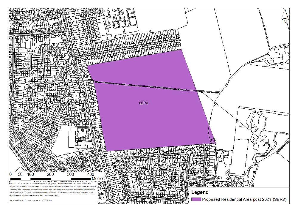
Figure 14: South East Ashingdon
Concept Statement:
Development of this site should provide 500 dwellings, of which at least 175 should be provided as ‘tenure blind’ affordable housing units. The site will accommodate no more than 500 dwellings, unless it can be demonstrated that:
- The additional number of dwellings are required to maintain a five year-land supply; and
- The additional number of dwellings to be provided on the site is required to compensate for a shortfall of dwellings that had been projected to be delivered within the location identified in the adopted Core Strategy.
In any event, the total number of dwellings provided should not exceed 500 by more than 5%.
All dwellings should comply with the Lifetime Homes Standard plus a minimum of 15 dwellings should be built to full wheelchair accessibility standards. A Lifetime Homes and wheelchair accessibility housing statement will be required to accompany any planning application to demonstrate how the proposed development will address the 16 Lifetime Homes Standard design criteria, and show on plans how criteria 1, 3, 5, 6, 7, 10, 12, 14 and 15 will be achieved.
Compliance with the appropriate Code for Sustainable Homes standard will also be required, and a minimum of 10% of the energy should be generated by on-site renewable and low carbon sources, unless demonstrated as part of a planning application that this would be unviable.
The development should be sensitive to the character and setting of the surrounding area, and whilst it should not be of an overly uniform design, it should be of high quality. The principles of the Essex Design Guide should be taken into account. Trees and hedges should be developed in garden areas along the northern, western and southern boundaries of the site to create a green buffer in perpetuity between new and existing development, whilst promoting integration.
The loss of any trees on site or in the vicinity of the site should be appropriately mitigated against, with the provision of replacement trees on a like-for-like basis.
Amenity greenspace and appropriate landscaping should be provided throughout the site.
At least 3.6 hectares of natural/semi-natural greenspace which is publicly accessible should be provided and integrated into the development. A green buffer to the east should be provided following the existing tree line further to the east to soften the boundary of the site. Within this area, a greenway linking Oxford Road in the north to The Drive in the south should be developed, enhancing access/egress to King Edmund School in the north and the facilities and services in Rochford town centre in the south. This buffer will not form part of the development area, but will be situated in the Green Belt to the east of the residential settlement. The green buffer should take the form of parkland which is publicly accessible and integrated into the development.
A minimum of 0.06 hectares should also accommodate play space within the development, although the exact quantum may depend on the type of play space provided. Play space may take the form of a combination of local areas for play (LAP), local equipped areas for play (LEAP) and/or neighbourhood equipped areas for play (NEAP). This should be determined in consultation with the Council, however, for such a development at least a LEAP which requires a minimum of 0.04 hectares should be provided on-site. These areas should be appropriately distributed across the site to enable the local community to easily access them. They should be well located within the development so that it is open, welcoming, safe and easily accessible from pedestrian routes, and within an appropriate walking time. The play spaces should be suitably landscaped and visible from nearby dwellings or well used pedestrian routes. In general, the design of this should follow the principles established by Fields in Trust and Play England.
This site should accommodate the appropriate amount of youth facilities and community facilities for this development and the site on land identified within Policy SER5. Proportionate financial contributions towards this provision will be made from this development to support the delivery of appropriate facilities on this site. The type of youth facilities required to accompany development should reflect the needs of the target age-group. This could take the form of indoor and / or outdoor facilities but in any case, a minimum of 0.02 hectares for outdoor youth facilities should be provided. The type of youth facilities provided should be determined in consultation with young people and agreed at the planning application stage. Guidance on the provision of outdoor youth facilities produced by Fields in Trust should be referred to.
Community facilities should be located towards the central/western section of the site, so that they are accessible to the surrounding development, including new and existing communities. The exact siting and type of facilities provided should be determined in consultation with the local community at the planning application stage.
Small-scale retail (A1) development in the form of neighbourhood shops should be integrated into the development, and located in proximity to the community facilities to create a hub of services and facilities that are accessible to new and existing communities. The number and distribution should be determined at the time of a planning application, having regard to viability.
Allotments (a minimum of 0.2 hectares) should be provided on this site (financial contributions from the development of Policy SER5 should be made accordingly).
The above calculations of greenspace, play space, allotments and youth facilities requirements are based on 500 dwellings being provided on the site. If a greater number are provided, the provision of such facilities should increase proportionately.
There is a pylon to the east of the site which should be removed prior to development, and repositioned further than 60 metres from any residential development or diverted underground. The presence of underground electricity cables running east to west through the site may need to be considered at the planning application stage.
Links to the neighbouring Local Wildlife Site to the east/south east of the site should be explored. Given the proximity of the site to this area of ecological value, a management plan for the Local Wildlife Site should be prepared in consultation with relevant bodies such as the Council, Natural England and the Essex Wildlife Trust, given potential increased recreational pressure on the site.
At least two vehicular access/egress points onto Ashingdon Road should be provided, and potentially a third to the south of the site should be explored in consultation with the local highway authority. Financial contributions towards local highway capacity and infrastructure improvements will be required.
If access/egress points to the south of the site are considered acceptable, then the arrangement of the roads on-site should be such that it would not facilitate the creation of a through-route between Ashingdon Road and The Drive/Percy Cottis Road as these are residential areas.
Public transport infrastructure improvements and service enhancements will also be required. The potential for the existing bus route along Ashingdon Road to be diverted onto the site to serve the development, particularly the community facilities and local shops, should be explored.
Pedestrian and cycle routes should be provided throughout the site, ensuring connectivity between the different elements of development, particularly between residential and the community uses. Pedestrian routes to the south of the site should also be provided, particularly if vehicular routes are not considered to be acceptable in this location.
Links and enhancements to local pedestrian/cycling and bridleway network should be provided. A modal shift to reduce use of private vehicles and to encourage walking and cycling is particularly important in this location. Contributions towards the development of the proposed Sustrans cycle route may also be required.
A Transport Impact Assessment, including an assessment of air quality, must accompany any planning application to develop the site. This must examine the additional transport impacts that the development of this site will generate. Actions to address impacts identified through the Transport Impact Assessment must accompany the development of the site, or be provided prior to the commencement of development.
Attenuation Sustainable Drainage Systems (SUDS) of a size proportionate to the development should be used such as balancing ponds, swales, detention basins and green roofs. These could be incorporated into the greenspace provided on-site. Appropriate SUDS should be determined in consultation with Essex County Council. A drainage strategy should be prepared for the site.
In terms of wastewater transmission, the network should be modelled to assess capacity as there are numerous sewer flooding events on the downstream network within Rochford, which could be exacerbated by development of the site. Any issues identified should be resolved in conjunction with Anglian Water.
Connection from the existing main to the new development area, to be funded by the developer, will be required and upgrades to existing network may be needed. This should be determined in consultation with Essex and Suffolk Water.
A Health Impact Assessment must be undertaken and accompany any planning applications to develop the site. Actions required to address any negative impacts identified through the Health Impact Assessment must accompany the development of the site, or be provided prior to the commencement of development.
(23) Policy SER9 – West Great Wakering
Site Context:
Two sites have been identified on agricultural land to the south of the High Street and to the west of Little Wakering Road.
The site to the west of Little Wakering Road (Policy SER9a) is adjacent to existing residential development along its northern, eastern and southern boundaries. There is a temporary road further to the west of this site.
The site to the south of the High Street (Policy SER9b) is adjacent to existing residential development to the north, with Star Lane Industrial Estate to the west and the Star Lane Pits Local Wildlife Site (R35) to the south. There is wooded / scrubland area to the east of the site. The site is relatively low lying compared to Star Lane Industrial Estate to the west and residential development to the north.
New highway access onto both sites would be required.
Site Capacity:
The Core Strategy (Policy H3) identifies that the sites in this general location should have the capacity to accommodate a minimum of 250 dwellings during the plan period. The sites identified in Figure 15 are capable of providing 250 dwellings at a density of 30 dwellings per hectare, plus a flexibility allowance of 5%, if required. The overall site area is 13 hectares to take account of site constraints and to accommodate the following infrastructure, services and facilities:
- Local highway capacity and infrastructure improvements;
- Public transport infrastructure improvements and service enhancements;
- Link and enhancements to local pedestrian/cycling and bridleway network;
- Sustainable drainage systems;
- Public open space;
- Play space; and
- Youth facilities and community facilities.
The areas identified as SER9a (4.5 hectares) and SER9b (8.5 hectares) in Figure 15 will be safeguarded from development until 2021, unless required in order to maintain a five-year supply of deliverable housing land.
The principles for the development of these sites are set out in the Concept Statement.
Site Map:
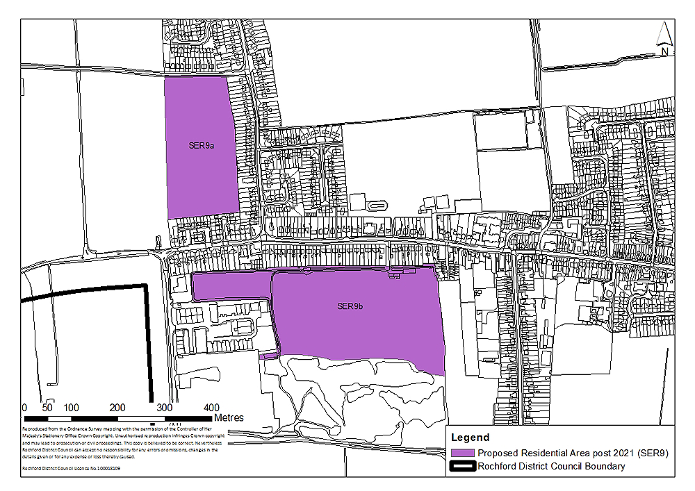
Figure 15: West Great Wakering
Concept Statement:
Development of this site should provide 250 dwellings, of which at least 87 should be provided as ‘tenure blind’ affordable housing units. The site will accommodate no more than 250 dwellings, unless it can be demonstrated that:
- The additional number of dwellings are required to maintain a five year-land supply; and
- The additional number of dwellings to be provided on the site is required to compensate for a shortfall of dwellings that had been projected to be delivered within the location identified in the adopted Core Strategy.
In any event, the total number of dwellings provided should not exceed 250 by more than 5%.
The sites will be safeguarded until post-2021 unless it can be demonstrated that they are required to be brought forward to contribute towards the District’s five-year housing supply.
All dwellings should comply with the Lifetime Homes Standard plus a minimum of seven dwelling should be built to full wheelchair accessibility standards. A Lifetime Homes and wheelchair accessibility housing statement will be required to accompany any planning application to demonstrate how the proposed development will address the 16 Lifetime Homes Standard design criteria, and show on plans how criteria 1, 3, 5, 6, 7, 10, 12, 14 and 15 will be achieved.
Compliance with the appropriate Code for Sustainable Homes standard will also be required, and a minimum of 10% of the energy should be generated by on-site renewable and low carbon sources, unless demonstrated as part of a planning application that this would be unviable.
At least 1.8 hectares of natural/semi-natural greenspace and a minimum of 0.2 hectares of amenity greenspace should be provided across the sites.
This open space should be primarily located between the site to the west of Little Wakering Road (Policy SER9a) and the temporary road to the west to as act as a green buffer. It would have benefits in landscape terms through reducing the visual impact of development from the surrounding highway network. It will not form part of the development area, but will be situated in the Green Belt to the west of the residential settlement. The green buffer should take the form of parkland which is publicly accessible and integrated into the development.
The site to the south of the High Street (Policy SER9b) is adjacent to a Local Wildlife Site which is located to the south. A green buffer between the development and the Local Wildlife Site should be provided to minimise disturbance. Given the proximity of the site and an area of ecological value, a management plan for the Local Wildlife Site should be prepared in consultation with relevant bodies such as the Council, Natural England and the Essex Wildlife Trust, given potential increased recreational pressure on the site.
Part of the area to the east of the site between Alexandra Road, particularly given its relationship with the Local Wildlife Site, has the potential to have ecological value. This area should be treated sensitively and disturbance should be avoided. The eastern boundary of the site (Policy SER9b) may benefit from an appropriately sized green buffer.
Trees and hedges should be developed in garden areas along the eastern and southern boundaries of the site to the west of Little Wakering Road (Policy SER9a) and along the northern boundary of the site to the south of the High Street (Policy SER9b) to create a green buffer in perpetuity between new and existing development, whilst promoting integration.
The loss of any trees on site or in the vicinity of the sites should be appropriately mitigated against, with the provision of replacement trees on a like-for-like basis.
Across the sites, a minimum of 0.03 hectares should accommodate play space, although the exact quantum may depend on the type of play space provided. Play space may take the form of a combination of local areas for play (LAP), local equipped areas for play (LEAP) and/or neighbourhood equipped areas for play (NEAP). This should be determined in consultation with the Council, however, for such a development at least a LEAP which requires a minimum of 0.04 hectares should be provided on-site. These areas should be appropriately distributed across the sites (Policy SER9a and SER9b) to enable the local community to easily access them. They should be well located within the development so that it is open, welcoming, safe and easily accessible from pedestrian routes, and within an appropriate walking time. The play spaces should be suitably landscaped and visible from nearby dwellings or well used pedestrian routes. In general, the design of this should follow the principles established by Fields in Trust and Play England.
Development of the sites should contribute towards the provision of local youth and community facilities. These could be provided on-site (within the area identified as Policy SEA9a and/or SEA9b), or alternatively, could take the form of financial contributions towards the development, enhancement and maintenance of existing or emerging facilities such as a Multi Use Games Area (MUGA). Each site should make a proportionate contribution to the provision of facilities both on- and off-site but in any case, a minimum of 0.01 hectares for outdoor youth facilities should be provided. This would depend on the distribution of dwellings across the sites. The type of youth facilities required to accompany development should reflect the needs of the target age-group, and should be determined in consultation with young people and agreed at the planning application stage. Guidance on the provision of outdoor youth facilities produced by Fields in Trust should be referred to.
The above calculations of greenspace, play space and youth facilities requirements is based on 250 dwellings being provided across the sites. If a greater number are provided, the provision of such facilities should increase proportionately.
The site to the south of the High Street (Policy SER9b) is adjacent to Star Lane Industrial Estate (Policy BFR1) which is allocated for residential development. The different land levels, particularly as the site to the south of the High Street is relatively low lying compared to Star Lane Industrial Estate to the west and adjacent residential development to the north, would need to be taken into consideration at the planning application stage in terms of integrating the development and access/egress provision.
Star Lane Industrial Estate (Policy BFR1) can be divided into two areas; the northern and the southern section. Should the southern section of the industrial estate be developed prior to the northern section, the site to the south of the High Street (Policy SER9b) should be well linked and integrated into any development on the southern section in terms of providing adequate access/egress to the highway network.
An appropriately sized green buffer between the site to the south of the High Street and the northern section of the industrial estate, should it not come forward prior to the development of the site, will be required. However, this should not restrict future integration of the two sites.
Pedestrian and cycle routes should be provided throughout the sites, ensuring connectivity between the different elements of development, particularly between residential and the community uses.
One point of access/egress onto the highway network may be required for each site, depending on the distribution of dwellings between them. This should be determined in consultation with the local highway authority. Connection to the highway network for the site to the west of Little Wakering Road (Policy SER9a), may be provided to the north onto Barrow Hall Road and/or to the south onto Southend Road. The site to the south of the High Street (Policy SER9b) should connect the High Street and, provided appropriate integration is enabled between this site and the land within Policy BFR1, with Star Lane to the west. However, this should be determined at the planning application stage in consultation with the local highway authority.
The proximity of the site to the south of the High Street (Policy SER9b) and new employment land to the south of Great Wakering (Policy NEL3) and in particular the impact on the highways network would also need to be considered at the planning application stage.
Development to the east of Star Lane and to the south of the High Street (Policy SER9b, BFR1 and NEL3) should be comprehensively planned to enable integration between these different land uses when they are delivered. One access/egress point onto Star Lane to serve these developments should be carefully considered at the planning application stage to avoid a proliferation of access/egress roads along Star Lane. Access/egress to the land within Policy SER9b should not go through the Local Wildlife Site but should be provided to the north east corner of the southern section of the industrial estate, if delivered prior to the northern section. Any impact on the existing footpath (from Star Lane eastwards towards Alexandra Road) would also need to be considered.
Pedestrian links to the north of the land within Policy SER9b should be provided to enhance connectivity to the High Street.
Link and enhancements to local pedestrian/cycling and bridleway network should be provided. Financial contributions towards the development of Greenway 20 to the west may also be required.
Financial contributions towards local highway capacity and infrastructure improvements and public transport infrastructure improvements and service enhancements will be required to accompany development.
A Transport Impact Assessment, including an assessment of air quality, must accompany any planning application to develop the site. This must examine the additional transport impacts that the development of this site will generate. Actions to address impacts identified through the Transport Impact Assessment must accompany the development of the site, or be provided prior to the commencement of development.
The severance of the two sites has the potential to impact on the range of Sustainable Drainage Systems (SUDS) developed. Attenuation SUDS of a size proportionate to the development should be used such as balancing ponds, swales, detention basins and green roofs. These could be incorporated into the greenspace provided on- and/or adjacent to the site. Appropriate SUDS should be determined in consultation with Essex County Council. A drainage strategy should be prepared for the sites.
The capacity constraints in relation to Southend Waste Water Treatment Works are noted (both wastewater transfer and transmission). This will have to be overcome at the design stage in conjunction with Anglian Water.
Connection from the existing main to the new development area, to be funded by the developer, will be required and upgrades to existing network may be needed. This should be determined in consultation with Essex and Suffolk Water.
A Health Impact Assessment must be undertaken and accompany any planning applications to develop the site. Actions required to address any negative impacts identified through the Health Impact Assessment must accompany the development of the site, or be provided prior to the commencement of development.
Whilst being sensitive to the character and setting of the surrounding area, the development should not be of an overly uniform design but should be of high quality. The principles of the Essex Design Guide should be taken into account. Development of land to the south of the High Street (Policy SER9b) may be of lower density than the site to the west of Little Wakering Road (Policy SER9a) to reflect the presence of the Local Wildlife Site. This should be determined at the planning application stage.
Gypsy and Traveller Allocations
The Core Strategy recognises that the need and demand for Gypsy and Traveller sites in the District has, historically, been very low, especially when compared with other areas of Essex. However, even this low demand has not been met in the past.
At the regional level, a single-issue review was prepared in 2009 assessing the need for Gypsy and Traveller pitch provision. To meet the requirements of this assessment, Policy H7 of the Core Strategy identifies that 15 pitches by 2018 must be provided to meet the needs of these communities. This is in addition to the seven authorised pitches recorded in the Annual Monitoring Report 2010-2011.
The Core Strategy also states that given the historically low demand within the District, provision for any additional pitches post 2018 will be subject to a further review of need.
(8) Policy GT1 – Gypsy and Traveller Accommodation
Site Context:
The site identified for Gypsy and Traveller accommodation is adjacent to an employment land allocation to the west of Rayleigh (see Policy NEL2). It is degraded greenfield land situated in the western part of the District, in accordance with the Core Strategy, at the junction of the A1245 and the A127. There is existing access onto the adjacent site from the A1245, and additional potential access points to the south east of the adjacent site onto the A127 slip road and onto the A127 from the field to the west of the site.
The site area is 1 hectare. The minimum site size to accommodate the required 15 pitches is 0.75 hectare. By identifying an area of 1 hectare, the allocation incorporates a degree of flexibility to accommodate future additional need, ancillary facilities and to ensure that a green buffer between the site and adjacent employment uses is provided.
There is a significant increase in the height of the land along the northern boundary leading up to the train line and a slight decrease in the height of the land at the entrance onto the A1245. The field to the west of the site is relatively flat but there is a significant increase in the height of the land on the northern and western boundaries where it meets the train line and A130 respectively.
Pylons are situated to the north west and south west of the site, and further to the east of the A1245. The pylons are further than 60 metres from the site.
There are trees and grassy areas, areas of waste material, unmade roads/tracks through the site, caravans and other physical structures throughout the site including buildings and metal containers.
Site Capacity:
The Core Strategy (Policy H7) identifies that the site should have the capacity to accommodate 15 pitches by 2018.
To accommodate 15 pitches, a minimum site size of 0.75 hectares would be required. The area of the site is 1 hectare, affording it a degree of flexibility and allowing for the provision of amenity areas.
The principles for the development of this site are set out in the Concept Statement.
Site Map:
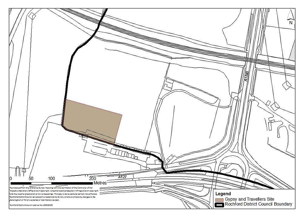
Figure 16: Gypsy and Traveller Accommodation
Concept Statement:
The site should be appropriately sized and suitably designed to enable the siting of a mobile home, touring caravan and a utility building, together with space for parking for each pitch. Consideration may be given to circular or horseshoe designs rather than the more traditional linear layout of pitches.
It is essential that the site is managed in a way that ensures it is open and accessible to the traveller community. Specifically, there will be a need to ensure that travellers, in appropriate circumstances, can be offered a pitch when required as part of the process of dealing with unauthorised sites in the district. On that basis, the Council’s preference is for the creation of a new municipal site that will be positively managed for the benefit of the traveller community and will ensure that a pitch can be offered when required in a simple and straightforward way. To this end the Council will seek to acquire this land and will ensure that it is appropriately managed by or on behalf of the Council.
Site access / egress to the adjacent employment allocation (Policy NEL2) must also facilitate access / egress to this site. The internal road layout should be such that traffic for the employment site, particularly in relation to the heavier employment uses, should not impact on the site. This objective is aided by the position of this site relative to Policy NEL2.
Given past/current uses this site may require decontamination. A contaminated land study should be undertaken prior to development, and decontamination undertaken as required.
The site boundary must provide clear demarcation of the perimeter of the site, so as to prevent nuisance for existing residents created by others seeking to move on to the site without permission. Boundaries should take into account adjoining land uses, and be designed with the safety and protection of children in mind.
Being located near an industrial area or process and a main road, fencing and substantial planting in the form of a green buffer should be used to provide screening for the site and to protect the amenity of residents. A range of different boundaries may be used including fences, low walls, hedges and natural features. The aim should be to achieve a boundary that is sympathetic to, and in keeping with, the surrounding area.
Design principles such as providing a clear gap of 3 metres within the inside of all site perimeter boundaries as a fire prevention measure should be accounted for. The local fire and rescue authority should be consulted.
The site layout and design should ensure a degree of privacy for individual households, but without inhibiting the important sense of community.
Enough space must be provided to permit the easy manoeuvrability of resident’s own living accommodation both to the site and subsequently on to a pitch. All routes for vehicles on the site, and for access/egress to the site, must allow easy access for emergency vehicles and safe places for turning vehicles.
Appropriately located vehicular and walking routes through the site should be provided to enhance security and community safety.
Public and private space should be clearly defined, and appropriate landscaping within the site will be required. The provision of a well-integrated communal recreation area for children of all ages, including the provision of play space, within the site should be considered.
There may be constraints to the wastewater treatment and transmission infrastructure in this location. Suitable sanitation may be more appropriately provided through provision of a septic tank. This should be determined at the planning application stage, and in consultation with Anglian Water.
Connection from the existing main to the new development area, to be funded by the developer, may be required and upgrades to existing network may be needed. This should be determined in consultation with Essex and Suffolk Water.
Local representative groups should be consulted at the planning application stage to ensure that the design of the site meets local need.