Allocations Submission Document
(1) 5. New Employment Land Allocations
Introduction
To compensate for the reallocation of four existing employment sites for alternative uses and to accommodate additional employment uses, the Core Strategy (Policy ED4) identifies that new employment land should be allocated to the west of Rayleigh, to the south of Great Wakering and to the north of London Southend Airport.
A total of 18 hectares will be allocated to compensate for the loss of existing employment land at Star Lane Industrial Estate, Eldon Way/Foundry Industrial Estate, Stambridge Mills and Rawreth Industrial Estate. A further 2.2 hectares of office space, on land to the south of London Road and within the town centres of Rayleigh and Hockley (which will be explored through the preparation of Area Action Plans), will also be allocated as set out in Policy ED4.
West of Rayleigh
New employment land to the west of Rayleigh will accommodate businesses displaced from Rawreth Industrial Estate as well as providing some additional office space. Given the varying nature of some of the businesses on the industrial estate (heavy industry, waste transfer etc.) it is appropriate to allocate two sites to the west of Rayleigh.
(6) Policy NEL1 – South of London Road, Rayleigh
Site Context:
The site is located to the south of London Road in the area between Little Wheatley Chase and St Johns Drive. It encompasses brownfield land which is predominantly in commercial use and agricultural land.
Uses on the brownfield land include two nurseries, a café and a dwelling. There are several linear hedgerows/tree belts dividing the brownfield land.
There is a watercourse running along the northern edge of the field to the east which appears to have been diverted underground at the point where it meets the area of previously developed land, then re-emerging to the east of the café, and again at the western end of the site. There is also a watercourse running through the centre of the brownfield land between the two nurseries.
Pylons are located to the south and north east of the site (to the north of London Road) with overhead electricity cables crossing the south eastern corner of the brownfield land and across the field to the east.
There is a Tree Preservation Order area in proximity to the south western corner of the site.
Site Capacity:
The site to the south of London Road is 5.1 hectares. Policy ED4 of the Core Strategy identifies certain characteristics for the site:
- Able to accommodate employment uses displaced by residential redevelopment of Rawreth Lane Industrial Estate;
- Be suitable for high-quality office and industrial development;
- A versatile layout and design that can accommodate a range of uses and can be adapted to meet changes in the economy;
- Accessible by a range of transport options; and
- Good links to the A130 and A127.
The allocated area to the south of London Road has the capacity to accommodate light industrial and office businesses displaced from Rawreth Industrial Estate and additional office uses. It is envisaged that the existing uses on site will be retained.
Figure 20 shows the extent of the site to the south of London Road.
The principles for the development of this site are set out in the Concept Statement.
Site Map:
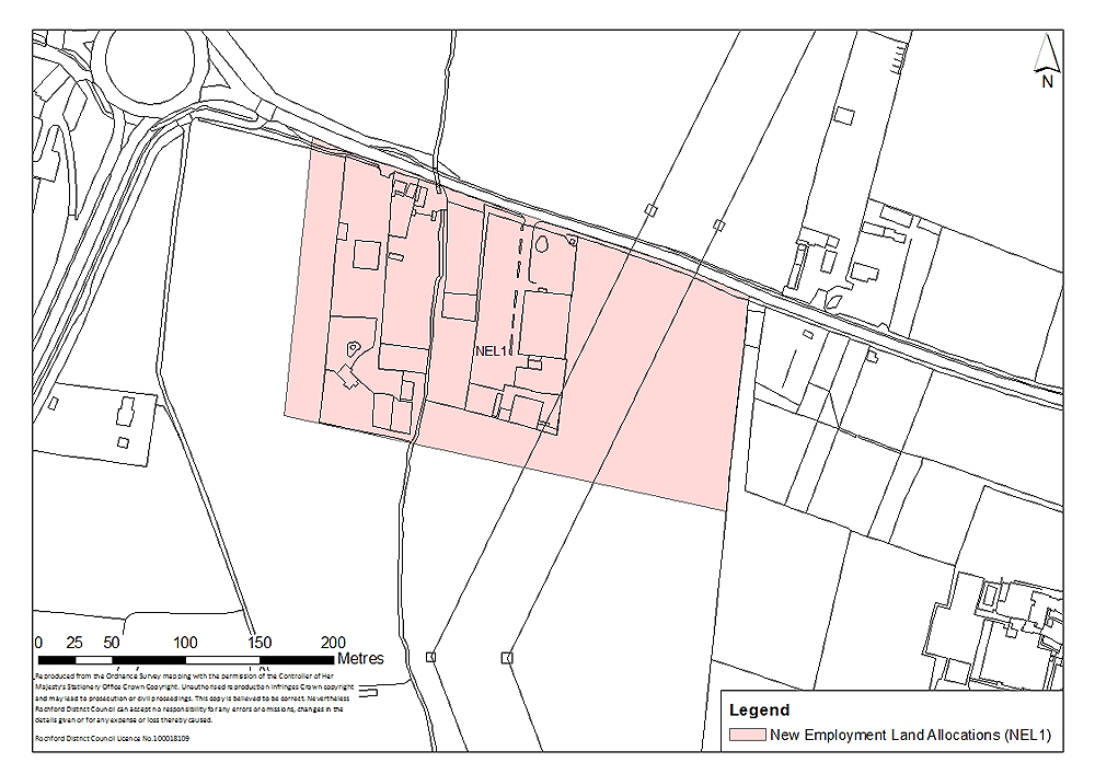
Figure 20: Employment land to the south of London Road, Rayleigh
Concept Statement:
Development of this site should be considered in conjunction with residential development between London Road and Rawreth Lane (Policy SER1), in particular the impact on the highway network and the local landscape.
Existing businesses on site should be retained as far as practicable. In addition this site should accommodate light industrial and office uses displaced from development identified in Policy BFR4. It is anticipated that this would be accommodated on 0.45 hectares of land to the west of the existing uses on the site. Additional high-quality office accommodation should also be provided on 2.2 hectares of land to the east of the existing uses.
The site should be of a versatile layout and design that can accommodate a range of uses and can be adapted to meet changes in the economy. Buildings should meet at least the ‘very good’ BREEAM rating, and at least 10% of the energy requirements should be generated by on-site renewable and low carbon sources, unless demonstrated as part of a planning application that this would be unviable.
As this site does not extend westwards to meet St Johns Drive or follow an established boundary along its southern edge, a substantial green buffer to the west and south of the site will be required to ensure the defensibility of the Green Belt boundary in this location. The green buffer will not form part of the development area, but will be situated in the Green Belt to the west and south of the employment site. Existing trees on-site and along the boundaries of the site should be retained, and additional landscaping along the northern and eastern boundaries of the site should be provided.
There is also a Tree Preservation Order area in proximity to the south western corner of the site which may need to be taken into consideration. Any adverse impact on this should be avoided. The loss of any trees on site or in the vicinity of the site should be appropriately mitigated against, with the provision of replacement trees on a like-for-like basis.
There are several ponds on the already developed area, a watercourse and hedgerows/tree belts running through it which may have biodiversity value. Potential habitat/biodiversity loss would need to be mitigated against.
The presence of pylons to the south of the site, and overhead electricity cables crossing the eastern section of the site towards London Road would need to be considered at the planning application stage.
Attenuation Sustainable Drainage Systems (SUDS) of a size proportionate to the development should be used such as balancing ponds, swales, detention basins and green roofs. This could be provided on-site and/or adjacent to the site on greenspace provided to the south. Appropriate SUDS should be determined in consultation with Essex County Council. A drainage strategy should be prepared for the site.
In terms of wastewater treatment and transmission, the network may need to be modelled. This should be determined at the planning application stage. Any issues identified should be resolved in conjunction with Anglian Water.
Connection from the existing main to the new development area, to be funded by the developer, may be required and upgrades to existing network may be needed. This should be determined in consultation with Essex and Suffolk Water.
The site should be accessible by a range of transport modes; enhancements in public transport would be required. This may take the form of financial contributions to the bus route to the north of London Road (see Policy SER1).
Investment in walking (particularly as there is no public footpath along the southern side of London Road to the north of the site) and cycling would be required. The site should facilitate and link to Greenway 13 to the south/south east.
A new junction along London Road, linked to the residential development to the north of London Road (Policy SER1), should be utilised to provide appropriate access/egress onto and off the site.
A Transport Impact Assessment, including an assessment of air quality, must accompany any planning application to develop the site. This must examine the additional transport impacts that the development of this site will generate. Actions to address impacts identified through the Transport Impact Assessment must accompany the development of the site, or be provided prior to the commencement of development.
(9) Policy NEL2 – West of the A1245, Rayleigh
Site Context:
A larger site on degraded greenfield land to the west of Rayleigh, at the junction of the A1245 and the A127, has been identified. There is existing access onto the site from the A1245, and additional potential access points to the south east of the site onto the A127 slip road and onto the A127 from the field to the west of the site.
There is a significant increase in the height of the land along the northern boundary leading up to the train line and a slight decrease in the height of the land at the entrance onto the A1245. The field to the west of the site is relatively flat but there is a significant increase in the height of the land on the northern and western boundaries where it meets the train line and A130 respectively.
Pylons are situated to the north west and south west of the site, and further to the east of the A1245.
There are trees and grassy areas, areas of waste material, unmade roads/tracks through the site, caravans and other physical structures throughout the site including buildings and metal containers.
Site Capacity:
The entire site has an area of 8.8 hectares. Policy ED4 of the Core Strategy identifies certain characteristics for the site:
- Able to accommodate employment uses displaced by residential redevelopment of Rawreth Lane Industrial Estate;
- Be suitable for high-quality office and industrial development;
- A versatile layout and design that can accommodate a range of uses and can be adapted to meet changes in the economy;
- Accessible by a range of transport options; and
- Good links to the A130 and A127.
The site is able to accommodate heavier industry and waste transfer businesses displaced from Rawreth Industrial Estate. There is also capacity to accommodate a recycling facility (1.2 hectares).
The extent of the site to the west of Rayleigh is set out in Figure 21.
The principles for the development of this site are set out in the Concept Statement.
Site Map:
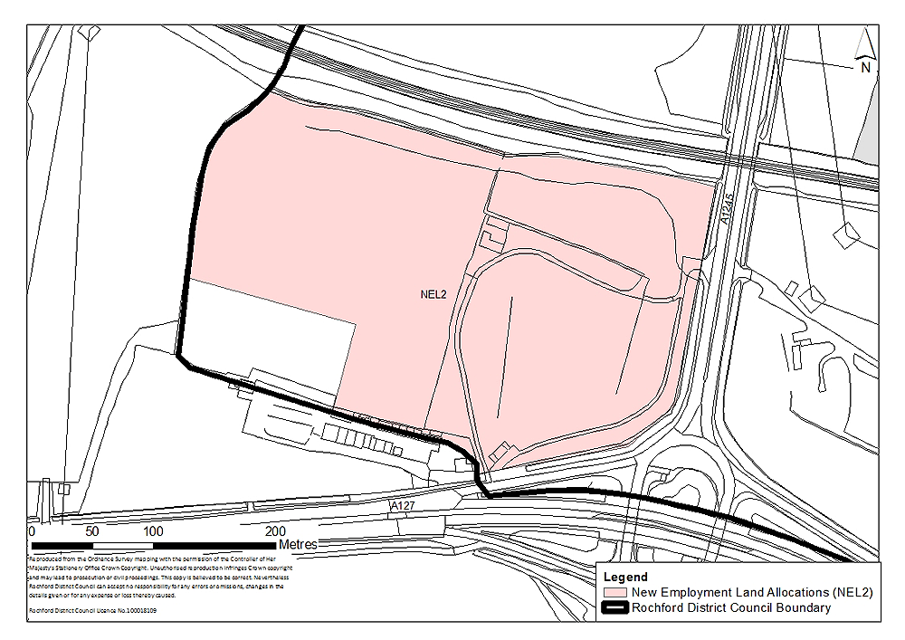
Figure 21: Employment land to the west of the A1245, Rayleigh
Concept Statement:
This site to the north of the A127 and east of the A1245 is strategically located to the west of Rayleigh. However, given its location at a key junction, highways access/egress on and off the site would need to be carefully considered. In particular a 'Design Manual for Bridges and Roads' compliant junction, a full road safety audit and transport assessment would be required. Appropriate access and egress should be determined in consultation with Essex County Council, and implemented prior to any development.
A Transport Impact Assessment, including an assessment of air quality, must accompany any planning application to develop the site. This must examine the additional transport impacts that the development of this site will generate. Actions to address impacts identified through the Transport Impact Assessment must accompany the development of the site, or be provided prior to the commencement of development.
Alongside heavier industrial uses, it is envisaged that this site will also accommodate a recycling centre. In addition, the site allocation adjoins the proposed Gypsy and Traveller site (Policy GT1). Consequently it is important that the site is sufficiently flexible to enable the appropriate siting of these different uses. Adequate parking and manoeuvrability around the site is important, and on-road parking should be avoided. The size of the site would facilitate this. It is important that whilst the Gypsy and Traveller site is adequately separated from the heavier employment uses in particular in the interests of residential amenity, the internal road layout within the site allows access / egress for both the employment uses and site GT1, whilst at the same time vehicles using the employment site will not be directed onto the adjacent residential area.
The different land levels in the area, particularly along the eastern boundary of the site, would need to be considered at the planning application stage in terms of access and egress and appropriate landscaping of the site.
Although the location of the site and the types of uses proposed may encourage use of private vehicles for many trips, the potential to enhance sustainable modes of travel to the site should be explored.
To strengthen the Green Belt boundary in this location, existing trees and hedgerows particularly to the south and west should be retained and enhanced, unless it can be demonstrated at the planning application stage that this would render development unviable/undeliverable. Existing trees and hedgerows along the northern, eastern and southern boundaries should also be retained and strengthened.
The loss of any trees on site or in the vicinity of the sites should be appropriately mitigated against, with the provision of replacement trees on a like-for-like basis.
Given past/current uses this site may require decontamination. A contaminated land study should be undertaken prior to development, and decontamination undertaken as required.
The site should be of a versatile layout and design that can accommodate a range of uses and can be adapted to meet changes in the economy. Buildings should meet at least the ‘very good’ BREEAM rating, and at least 10% of the energy requirements should be generated by on-site renewable and low carbon sources, unless demonstrated as part of a planning application that this would be unviable.
Heavier industrial uses displaced from Rawreth Industrial Estate (see Policy BFR4) should be accommodated on this site. Land should also be set aside for a new recycling centre (to accommodate the relocation of the site along Castle Road in Rayleigh, allowing this former site within an existing residential area to be redeveloped for more appropriate uses). The recycling centre should be well related to access / egress points, so that visiting traffic is not directed through heavier employment areas.
There are pylons to the north west and south west of the site, and further to the east of the A1245. A substantial green buffer should be provided between this site and the adjacent Gypsy and Traveller site, to protect the amenity of residents. The size of the site allows for this, whilst accommodating the required employment uses.
In terms of wastewater treatment and transmission, the network may need to be modelled. This should be determined at the planning application stage. Any issues identified should be resolved in conjunction with Anglian Water.
Connection from the existing main to the new development area, to be funded by the developer, may be required and upgrades to existing network may be needed. This should be determined in consultation with Essex and Suffolk Water.
Attenuation Sustainable Drainage Systems (SUDS) of a size proportionate to the development should be used such as balancing ponds, swales, detention basins and green roofs. Appropriate SUDS should be determined in consultation with Essex County Council. A drainage strategy should be prepared for the site.
(8) Policy NEL3 – South of Great Wakering
Site Context:
The site to the south of Great Wakering is located on agricultural land to the east of Star Lane, south of proposed residential development of the former Star Lane Brickworks in Great Wakering (Site BFR1).
There are trees and hedgerows partially bounding the site to the north and west, and there is a Local Wildlife Site (R35 Star Lane Pits) is situated to the north/north east of the site.
An access road runs along the northern boundary of the site which provides vehicular access to the Local Wildlife Site. There is also a public right of way running through the northern section of the site.
Site Capacity:
The site is 2.5 hectares in size. Businesses displaced from Star Lane Industrial Estate, which excludes the part of the site encompassing the disused brickworks (Policy BFR1), will be accommodated on this site.
Figure 22 shows the extent of the site to the south of Great Wakering.
The principles for the development of this site are set out in the Concept Statement.
Site Map:
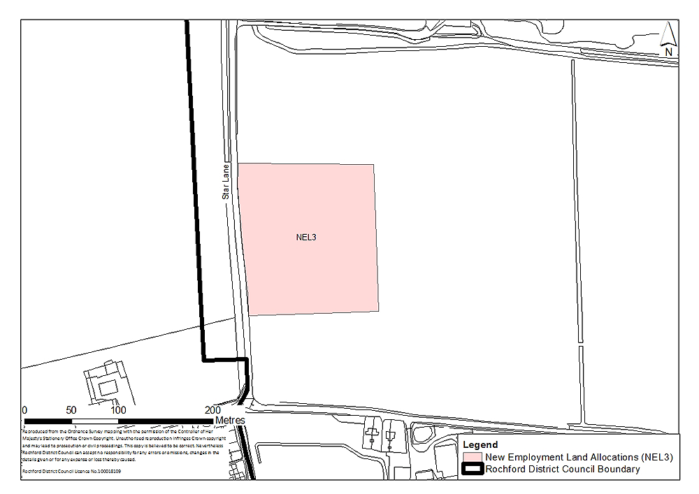
Figure 22: Employment land to the south of Great Wakering
Concept Statement:
Situated to south of the residential envelope of Great Wakering, this employment land is not well related to the strategic road network but provides access to local employment opportunities.
The site should be of a versatile layout and design that can accommodate a range of uses and can be adapted to meet changes in the economy. Buildings should meet at least the ‘very good’ BREEAM rating, and at least 10% of the energy requirements should be generated by on-site renewable and low carbon sources, unless demonstrated as part of a planning application that this would be unviable.
The site’s location 140 metres to the south of existing development in Great Wakering, allows for an adequate separation of industrial uses and residential uses to ensure residential amenity. However, with open fields to the north, south, and west there is no existing features which provide defensible Green Belt boundaries in these directions. As such, development of the site must be accompanied by landscaping to the north, south and east, creating a new Green Belt boundary. Significant landscaping will also be required to ensure visual impacts on the approach from the south along Star Lane and east along Poynters Lane are minimised.
Such landscaped green buffers should be provided in the form of publicly accessible green space, with conditions attached to ensure that it has ecological value as a wildlife corridor. To the north, the landscaping should incorporate non-vehicular links to ensure the site is well connected to Great Wakering.
The types of uses permitted on site should be B1 (business) and B8 (storage and distribution), and the site should not become a ‘bad neighbour’ through noise, dust, or smells.
The site should be accessible by a range of transport modes; enhancements in public transport would be required.
Investment in pedestrian routes (particularly as there is no public footpath along the eastern side of Star Lane in this location) and cycling would be required. Financial contributions towards the development to Greenway 20 to the west may be required.
Development to the east of Star Lane and to the south of the High Street (Policy SER9b, BFR1 and NEL3) should be comprehensively planned to enable integration between these different land uses when they are delivered. One access/egress point onto Star Lane to serve these developments should be carefully considered at the planning application stage to avoid a proliferation of access/egress roads along Star Lane. The potential to utilise the existing access/egress for the Local Wildlife Site (which is in the Green Belt) to enable a combined access/egress point for these developments should be explored.
The vehicular access to the site will therefore be provided through the green buffer to the north of the site. Any impact on the existing footpath (from Star Lane eastwards to Alexandra Road) would also need to be considered and addressed.
A Transport Impact Assessment, including an assessment of air quality, must accompany any planning application to develop the site. This must examine the additional transport impacts that the development of this site will generate. Actions to address impacts identified through the Transport Impact Assessment must accompany the development of the site, or be provided prior to the commencement of development.
Improvements to the Star Lane / Poynters Lane junction should be addressed through the redevelopment of the site at the planning application stage, with the creation of a new roundabout with new vehicular access to the site from the south to be considered in detail in conjunction with Essex County Council Highways Authority.
In terms of wastewater treatment and transmission, the network may need to be modelled. This should be determined at the planning application stage. Any issues identified should be resolved in conjunction with Anglian Water.
Connection from the existing main to the new development area, to be funded by the developer, may be required and upgrades to existing network may be needed. This should be determined in consultation with Essex and Suffolk Water.
Attenuation Sustainable Drainage Systems (SUDS) of a size proportionate to the development should be used such as balancing ponds, swales, detention basins and green roofs. Appropriate SUDS should be determined in consultation with Essex County Council. A drainage strategy should be prepared for the site.
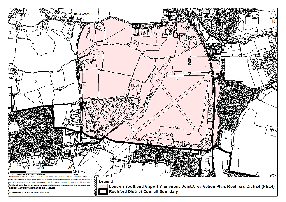
(3) Policy NEL4 – North of London Southend Airport
Site Context:
The importance of London Southend Airport and its surrounding area as a driver for the sub-regional economy is acknowledged within the Core Strategy, which identifies the area as a strategic location for additional employment land in the District.
The Core Strategy (Policy ED4) states that the Council will work with the private sector to secure the delivery of an Eco-Enterprise Centre within an employment allocation. As such, the area to the north of London Southend Airport is a potential location for this.
London Southend Airport has an important role to play in the economic development of the area as recognised in the Core Strategy. London Southend Airport and its environs extend into the boundaries of both Rochford District and Southend Borough. As such Rochford District and Southend Borough Councils are producing a Joint Area Action Plan to identify how best to realise the airport’s economic potential.
Currently the area surrounding the airport is used for employment uses, many of which are aviation focussed. The approach to London Southend Airport and its surrounding area is set out in Policy ED2 of the Core Strategy.
The extent of land allocated for employment to the north of London Southend Airport will be determined through the London Southend Airport and Environs Joint Area Action Plan.
It is not the role of the Allocations Document to allocate land or set detailed policies for London Southend Airport – this will be done through the London Southend Airport and Environs Joint Area Action Plan.
However, the extent of the area to be addressed by the London Southend Airport and Environs Joint Area Action Plan is illustrated in Figure 23.
Site Map: