Allocations Submission Document
7. Educational Land Allocations
Introduction
In setting the spatial strategy for the development of the District, the Core Strategy identifies locations where additional educational capacity would be required. Appendix H1 stipulates that new primary schools are required to accompany residential development in the locations north of London Road, Rayleigh and to the west of Rochford, and land must also be set aside to the east of Ashingdon to enable the expansion of King Edmund School.
In addition to new educational facilities, it is important that existing schools are protected from development that would undermine their important function, and that planning allows them to develop appropriately where required, whilst taking into consideration the purpose of the Green Belt.
(2) Policy EDU1 – North of London Road, Rayleigh
Context:
The number of dwellings proposed in this location result in the need for a new single form entry primary school. At least 1.1 hectares would be required to accommodate this school (as set out in Policy CLT2 of the Core Strategy).
The site for the primary school will be required to be well-related to residential areas, and well-located within the site identified within Policy SER1 of this document.
The area within the residential allocation should have the following characteristics:
- Roughly rectangular shape
- Flat ground
- Outside of flood risk area
- Away from high-voltage power lines
- Served by safe, direct pedestrian access well linked to nearby housing
- Well related to new public transport links
- Accessible via an adopted public highway with access to service buildings
- Nearby roads can be traffic calmed
The site to the north of London Road in Rayleigh within which the primary school will be located is identified in Figure 6.
(2) Policy EDU2 – West Rochford
Context:
The number of dwellings proposed in this location result in the need for a new single form entry primary school. At least 1.1 hectares would be required to accommodate this school (as set out in Policy CLT2 of the Core Strategy).
The site for the primary school will be required to be well-related to residential areas, and well-located within the site identified within Policy SER2 of this document.
The area within the residential allocation should have the following characteristics:
- Roughly rectangular shape
- Flat ground
- Outside of flood risk area
- Served by safe, direct pedestrian access well linked to nearby housing
- Well related to new public transport links
- Accessible via an adopted public highway with access to service buildings
- Nearby roads can be traffic calmed
The site to the west of Rochford within which the primary school will be located is identified in Figure 7.
(3) Policy EDU3 – King Edmund School
Context:
New residential development to the east of Ashingdon will be required to deliver, aside from improved access to King Edmund School, an additional 3 hectares of land in order to accommodate the required expansion of this secondary school to meet the additional need (Policy CLT3 of the Core Strategy). The area set out in Policy SER5 of this document can provide better access to the school, on a hectare of land set aside.
As such, additional land is required to be allocated to allow for the school to expand.
An additional 2 hectares of land is located to the east of Oxford Road to the rear of the existing school playing field to enable the expansion of the school. This area will remain within the Green Belt. Additional access to this location from Oxford Road should not be provided as this is a relatively narrow residential road.
The existing extent of the school site as well as the area set aside for expansion is identified in Figure 27.
Map:
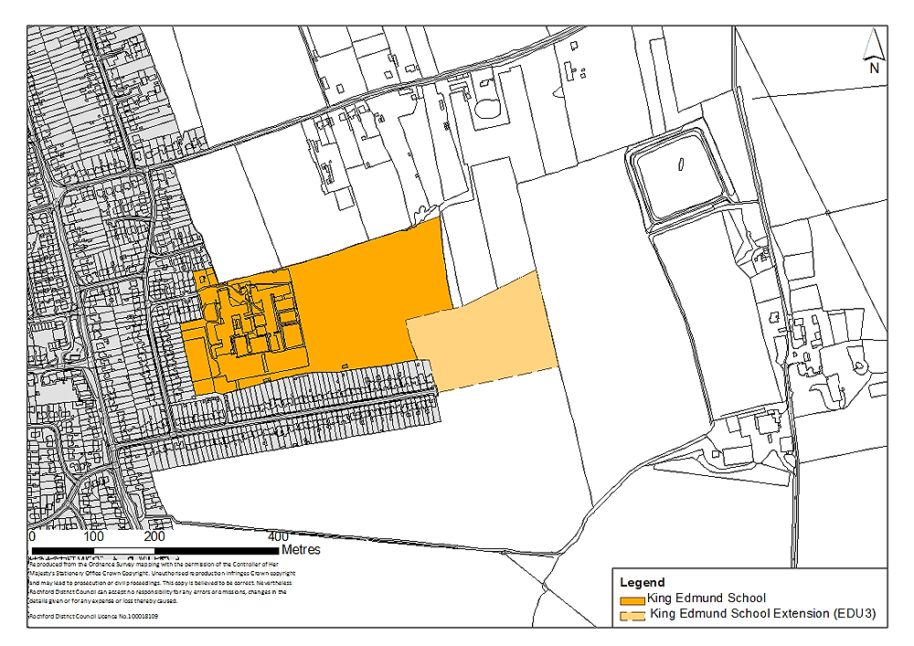
Figure 27: King Edmund School
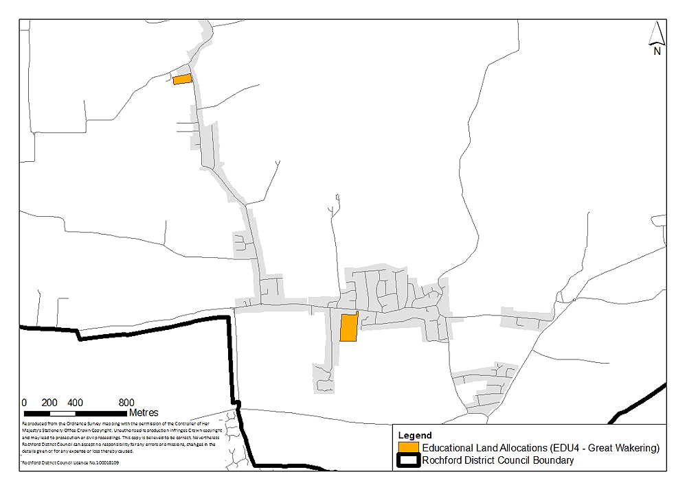
(1) Policy EDU4 – Existing Primary and Secondary Schools
Context:
There are 21 existing primary schools and four secondary schools in the District, many of which reside within the Green Belt. These important facilities should continue to be allocated for educational use. However, for those schools in the Green Belt, the existing developed part will not retain its Green Belt designation to ensure that they can expand as appropriate to meet local need. The existing playing fields will retain this designation and in effect will have a dual designation of Green Belt and education to prevent unnecessary encroachment into the Green Belt.
King Edmund School and the area of land set aside for the expansion is identified in Policy EDU3, however, the whole school site will also be identified below.
The existing schools that will be protected are as follows:
Primary Schools:
- Ashingdon Primary Academy, Fambridge Road, Ashingdon
- Barling Magna Community Primary School, Little Wakering Road, Barling
- Canewdon Endowed Primary School, Canewdon
- Great Wakering Primary School, High Street, Great Wakering
- Westerings Primary Academy, Sunny Road, Hawkwell
- Hockley Primary School, Chevening Gardens, Hockley
- Plumberow Primary School, Hamilton Gardens, Hockley
- Riverside Primary School, Ferry Road, Hullbridge
- St. Nicholas Church of England Primary School, Priory Chase, Rayleigh
- Our Lady of Ransom Primary School, Little Wheatley Chase, Rayleigh
- Down Hall Primary School, Brooklyn Drive, Rayleigh
- Edward Francis Primary School, Uplands Park Road, Rayleigh
- Glebe Infants and Junior School, Creswick Avenue, Rayleigh
- Grove Wood Primary School, Grove Road, Rayleigh
- Wyburns Primary School, Nevern Road, Rayleigh
- Rayleigh Primary School, Love Lane, Rayleigh
- Holt Farm Infant and Junior School, Ashingdon Road, Rochford
- Rochford Primary School, Ashingdon Road, Rochford
- Stambridge Primary School, Stambridge Road, Rochford
- St. Teresa’s Catholic Primary School, Ashingdon Road, Rochford
- Waterman Primary School, The Boulevard, Rochford
Secondary Schools:
- Greensward Academy, Greensward Lane, Hockley
- FitzWimarc School, Hockley Road, Rayleigh
- Sweyne Park School, Sir Walter Raleigh Drive, Rayleigh
- King Edmund School, Vaughan Close, Rochford (see also Policy EDU3)
The extent of these areas to be allocated are identified in Figures 28 to 33.
Maps:
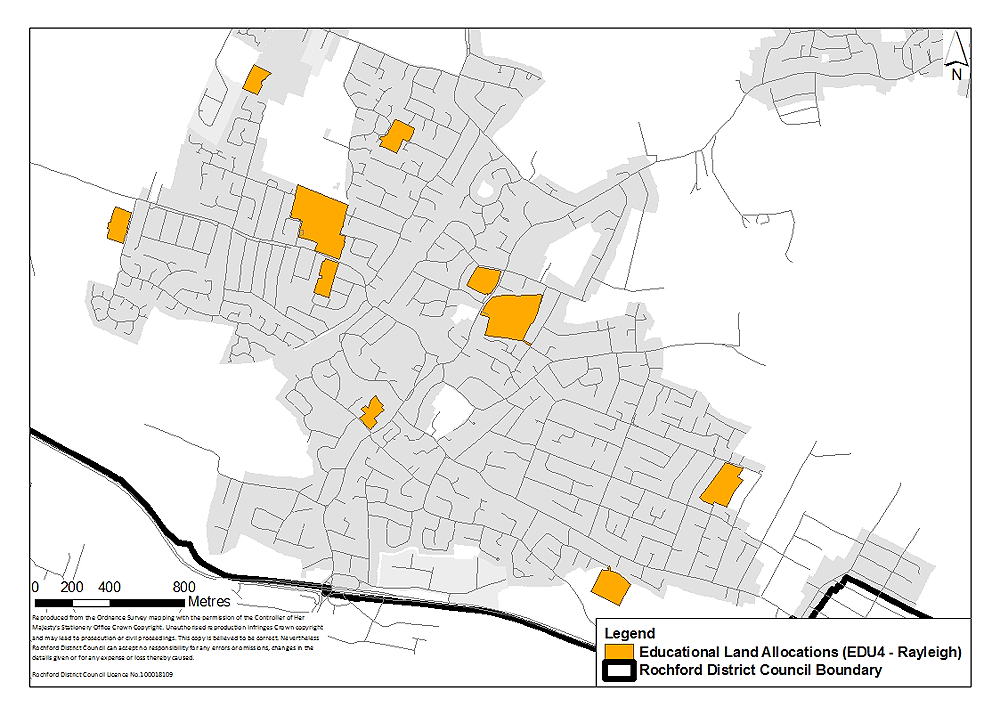
Figure 28: Existing Primary and Secondary Schools in Rayleigh
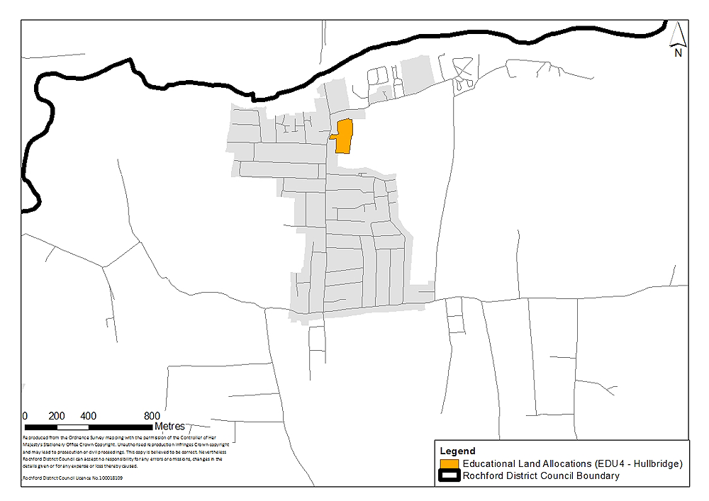
Figure 29: Existing primary and secondary schools in Hullbridge (NB No secondary schools in this area)
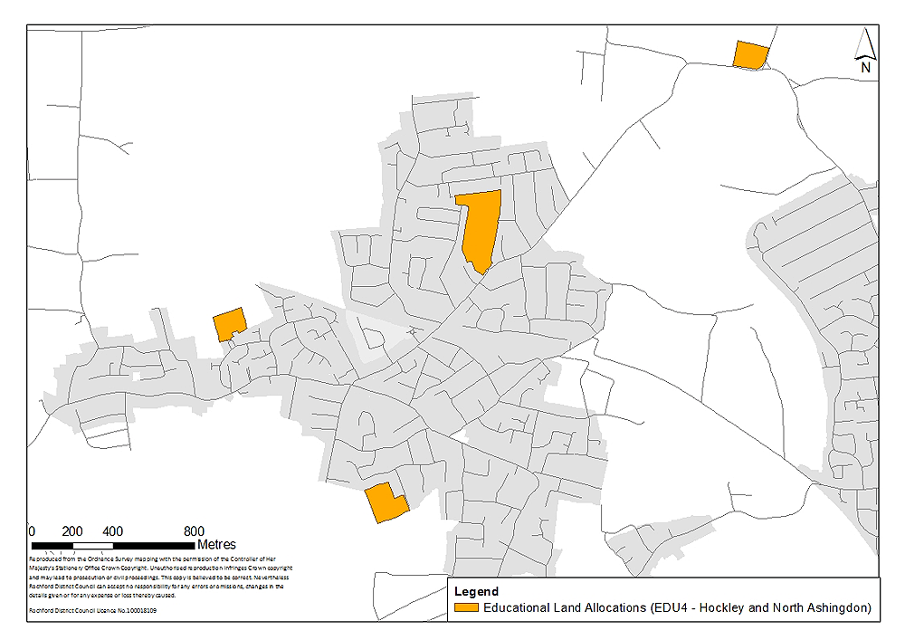
Figure 30: Existing primary and secondary schools in Hockley and North Ashingdon
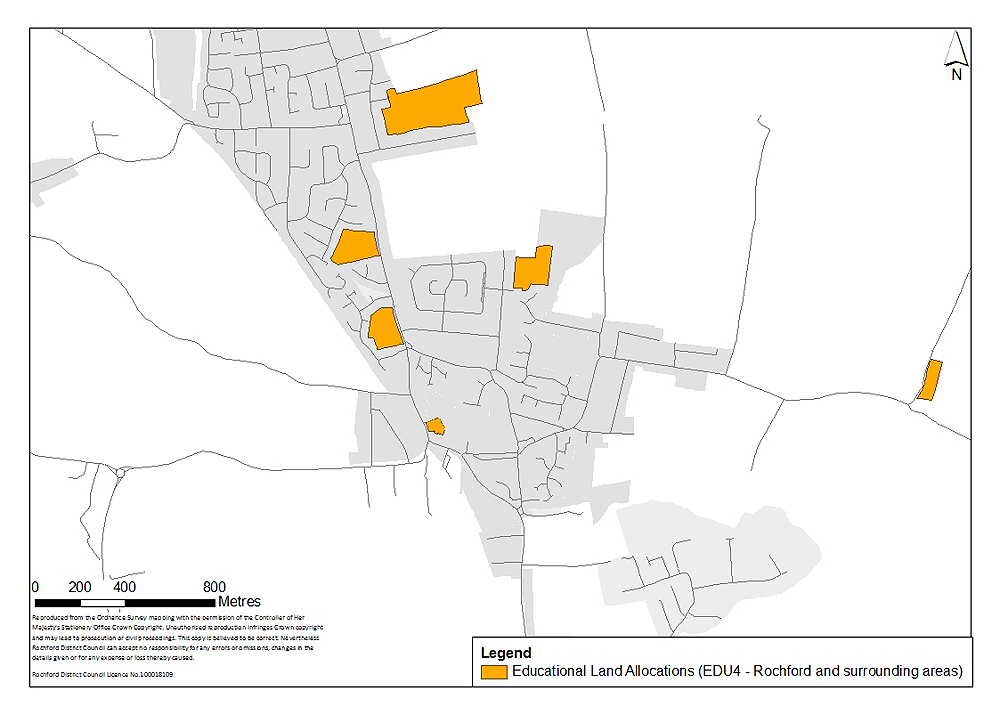
Figure 31: Existing primary and secondary schools in Rochford and surrounding area
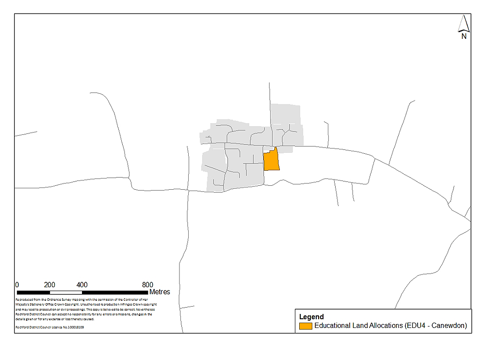
Figure 32: Existing primary and secondary schools in Canewdon (NB No secondary schools in this area)