Allocations Submission Document
6. Ecological and Landscape Allocations
Introduction
Being a coastal District, there are numerous areas of ecological importance, primarily along the estuaries of the rivers Crouch and Roach of national and international significance. Local areas of ecological value, however, also merit designation to protect these smaller scale habitats at a local level.
The District is predominantly Green Belt and its relatively rural nature also facilitates the recognition and designation of areas of landscape importance, along the estuaries and coastline as well as further inland.
The Core Strategy sets out the strategic approach to the protection and enhancement of the natural landscape and habitats (Policy ENV1). The Council has long encouraged policies that restrict development along the coast and estuaries in order to protect this irreplaceable natural resource. The NPPF provides guidance to local authorities on planning for development and protecting the coastal environment. It is particularly clear on the necessity of protecting the coastal environment (paragraph 114). The NPPF also emphasises the need to create, protect, enhance and manage networks of biodiversity and green infrastructure.
Ecological Allocations
Much of the District’s ecologically important areas, such as the rivers Crouch and Roach and Hockley Woods, are protected through a range of national and international nature conservation designations including designations such as Sites of Special Scientific Interest and Special Protection Areas (see chapter 12). However, at the local level there are areas of ecological significance albeit at a much smaller scale that justify recognition in their own right.
(3) Policy ELA1 – Local Wildlife Sites
Context:
Local Wildlife Sites are areas that are not designated under national or international statutory protection, but are considered to be of significant wildlife value. They were previously known as Sites of Importance for Nature Conservation and County Wildlife Sites. Alongside statutory protected areas, Local Wildlife Sites represent the minimum habitat we need to protect in order to maintain the current wildlife levels in Essex.
There are 39 areas in the District that have been identified as being suitable for designation as Local Wildlife Sites in the 2007 Local Wildlife Sites Review against current Local Wildlife Site selection criteria. The results of this assessment are detailed within the 2007 Review. The Local Wildlife Sites are mostly woodland, but also comprise areas of grassland, mosaic, coastal and freshwater habitats.
The largest of the all the Local Wildlife Sites is the Wallasea Island Managed
Realignment area, which covers an area of 90.3 hectares. Other significant Local Wildlife Sites include Magnolia Nature Reserve and Fields to the west of Ashingdon (29.2 hectares) and Wakering Landfill Site to the north east of Great Wakering (24 hectares).
| Code | Site Name | Area (hectares) |
|---|---|---|
| R1 | Kingley Wood |
|
| R2 | Hullbridge Road Meadow |
|
| R3 | Blounts Wood |
|
| R4 | Hockley Woods Complex |
|
| R5 | Grove Woods |
|
| R6 | Rawreth Hall Wood |
|
| R7 | Brandy Hole Marsh Extension |
|
| R8 | Hockleyhall/Crabtree Woods |
|
| R9 | Folly Wood |
|
| R10 | New England Wood |
|
| R11 | Bett's Wood |
|
| R12 | The Dome Grasslands |
|
| R13 | Edwards Hall Park |
|
| R14 | Marylands Wood |
|
| R15 | Plumberow Wood |
|
| R16 | Belchamps Camp, Hockley Woods |
|
| R17 | Gustedhall Wood |
|
| R18 | The Scrubs |
|
| R19 | Primrose Wood |
|
| R20 | Cottons |
|
| R21 | Beckney Wood |
|
| R22 | Potash Wood |
|
| R23 | Trinity Wood |
|
| R24 | Magnolia Nature Reserve and Fields |
|
| R25 | Hyde Wood |
|
| R26 | Doggetts Pond |
|
| R27 | Sutton Ford Bridge Pasture |
|
| R28 | River Roach at Rochford |
|
| R29 | Wood Sloppy |
|
| R30 | Butts Hill Pond |
|
| R31 | The Finches |
|
| R32 | Lion Creek Meadow |
|
| R33 | Canewdon Special Roadside Verge |
|
| R34 | Barling Pits |
|
| R35 | Star Lane Pits |
|
| R36 | Paglesham Seawall |
|
| R37 | Wakering Landfill Site |
|
| R38 | Great Wakering Common |
|
| R39 | Wallasea Island Managed Realignment |
|
The location of the Local Wildlife Sites as identified by the 2007 Local Wildlife Sites Review are shown in Figure 24.
Map:
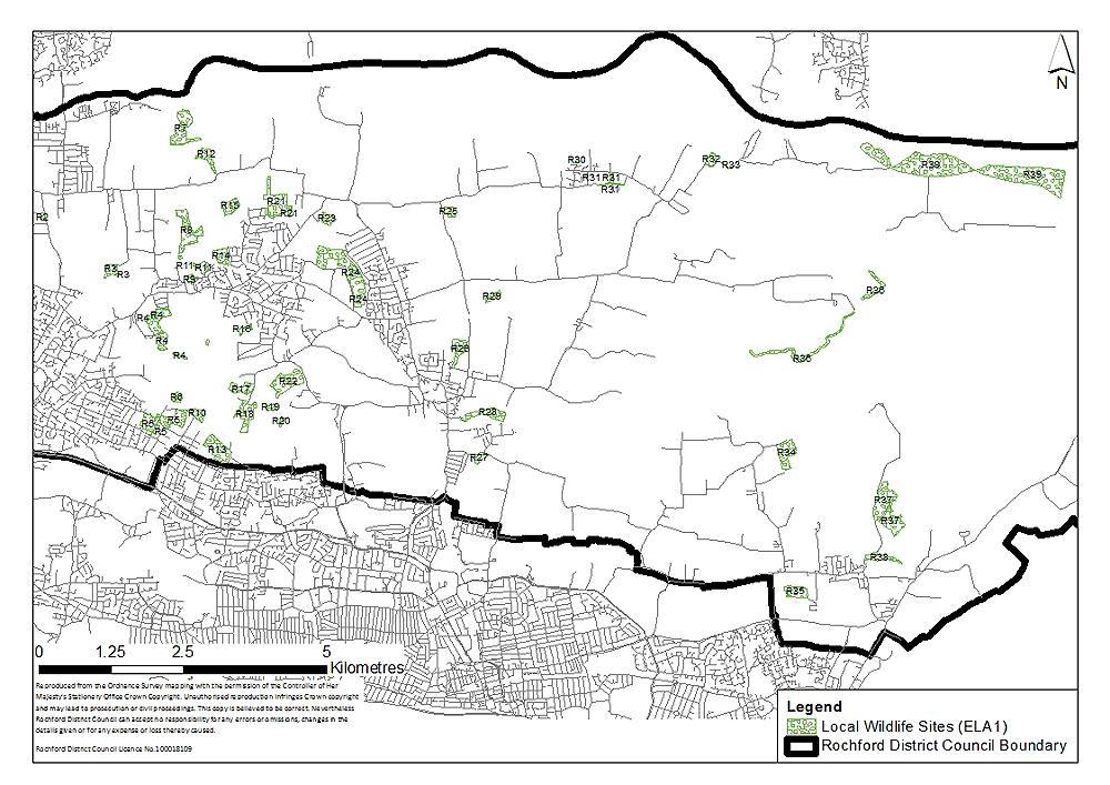
Figure 24: Local Wildlife Sites
Landscape Allocations
There are two principal landscape designations which require recognition at the local level; the Coastal Protection Belt to protect the undeveloped coastline of the rivers Crouch and Roach, and the Upper Roach Valley which protects the important landscape characteristics between the towns of Rayleigh, Hockley, Rochford and Southend.
(1) Policy ELA2 – Coastal Protection Belt
Context:
The extent of the area where the open and undeveloped coastline of Essex will be protected was initially defined at the regional level in the 1984 Coastal Protection Subject Plan as detailed within the Core Strategy. This was also supported through the adoption of the 2001 Essex and Southend-on-Sea Replacement Structure Plan, as well as the 2006 Replacement Local Plan.
The Council’s approach to managing development within the Coastal Protection Belt is set out in Policy ENV2 of the Core Strategy. It will protect and enhance the existing qualities of the coastline, take into consideration climate change and sea level rise, whilst not permitting any development in areas that are at risk from flooding, erosion and land instability and ensuring that exceptionally permitted development will not have adverse impacts on the open and rural character, historic features and wildlife of the coast, and must be within already developed areas.
Parts of the areas identified in Policy SER6 to the south west of Hullbridge and Policy SER7 to the south of Canewdon are situated in the Coastal Protection Belt. As such a small amendment to the Coastal Protection Belt designation in this location is required.
The open and undeveloped Coastal Protection Belt identified within Figure 25 will be protected and enhanced in accordance with Policy ENV2 of the Core Strategy.
Map:
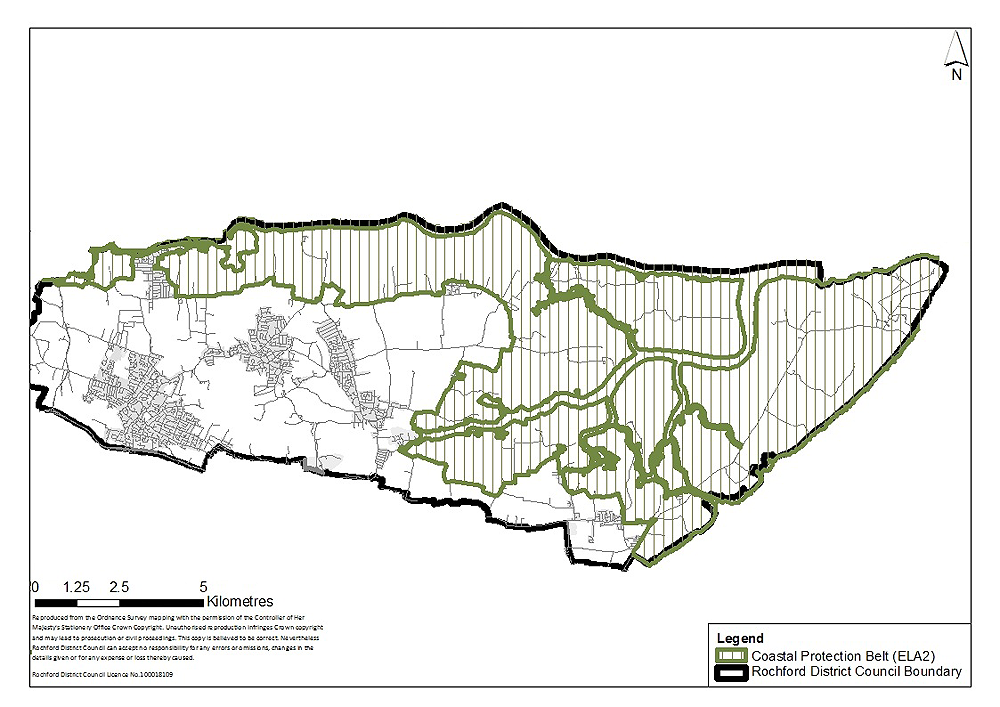
Figure 25: The Coastal Protection Belt
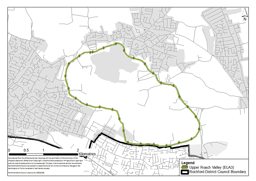
(1) Policy ELA3 – Upper Roach Valley
Context:
The need for more informal recreational space in south east Essex has been identified on numerous occasions over a number of years, including in the 1982 and 2001 Essex and Southend-on-Sea Replacement Structure Plans and the 2005 Thames Gateway South Essex Green Grid Strategy.
The Council has sought to help address this need through the establishment of Cherry Orchard Jubilee Country Park. Work began on the Country Park in 2002 and the park has been gradually expanded. The approach to the development of the Country Park is centred on ensuring the right conditions are in place in order for fauna and flora to flourish, and utilising the existing features of the landscape, all with the minimum of human interference.
Cherry Orchard Jubilee Country Park is situated within the Upper Roach Valley. The Upper Roach Valley is a large ‘green lung’ bounded by the towns of Rayleigh, Hockley, Rochford and Southend. This area was designated in the 2006 Rochford District Replacement Local Plan as a Special Landscape Area and as an Area of Ancient Landscape. The Upper Roach Valley has important landscape characteristics which deserve continued recognition.
Seven of the fourteen ancient woodlands found in the District, including Hockley Woods, lie within the Upper Roach Valley and there are also a number of Local Wildlife Sites (see Policy ELA1) situated within its boundaries. Policy URV1 of the Core Strategy supports the recognition of the Upper Roach Valley as a vast ‘green lung’ within the District and as an area providing informal recreation opportunities for local residents. The designation of this area presents opportunities for enhancing access to this potentially substantial recreational resource.
The Core Strategy states that the Upper Roach Valley will be protected from development which would undermine the area’s role as a green space providing informal recreational opportunities. It also supports the expansion of Cherry Orchard Jubilee Country Park and the creation of links with other parts of the Upper Roach Valley.
The area allocated as the Upper Roach Valley is illustrated in Figure 26. The Upper Roach Valley will be protected and enhanced in accordance with Policy URV1 of the Core Strategy.
Map: