Allocations Submission Document
(1) 12. Characteristics Map
There are a number of designations within Rochford District which, whilst are established through alternative mechanism to the Allocations Development Plan Document and therefore cannot be shown on the proposals map, are nevertheless important considerations in respect of planning decisions. It is therefore considered appropriate to bring these different designations together and illustrate them within this document.
National and International Ecological Designations
There is a wealth of existing ecological designations at the national and international level, protecting the distinctive coastal and inland environment of the District. Policy ENV1 of the Core Strategy sets out the Council’s commitment to maintain, restore and enhance areas if nature conservation importance.
These designations include the following:
-
Sites of Special Scientific Interest (SSSIs) – Designated by Natural England, using a set of specific criteria, the role of SSSIs is to uphold, for present and future generations, the diversity and geographic range of habitats, ecosystems, and species throughout England. There are three SSSIs in the District; Hockley Woods SSSI, Foulness SSSI and Crouch and Roach Estuaries SSSI.
-
Special Protection Areas (SPAs) – These are strictly protected sites classified for rare or vulnerable birds and regularly occurring migratory species. They are designated in accordance with Article 4 of the EC Directive on the conservation of wild birds (79/409/EEC). There are two SPAs in the District; Foulness and the Crouch and Roach Estuaries.
-
Special Areas of Conservation (SACs) – SACs have been designated under the EC Habitats Directive and as such are strictly protected. The habitat types and species that fall under this designation are those that are considered to be most in need of conservation at a European level (excluding birds). The whole of the Foulness and Crouch and Roach Estuaries falls under the SAC covering the Essex Estuaries. This relates to the seaward part of the coastal zone.
-
Ramsar Sites – These are wetlands of international importance that have been designated under the Ramsar Convention. There are two listed Ramsar Sites in District; Foulness and the Crouch and Roach Estuaries.
The Core Strategy (Policy ENV1) also sets out the Council’s commitment to the maintenance, restoration and enhancement of the Districts’ Ancient Woodland and Local Nature Reserves.
Ancient Woodland in England, as set out in the ‘Standing Advice for Ancient Woodland’18 by Natural England, is an area of woodland that has been wooded continuously since at least 1600 AD. However, continuously wooded in this context does not require there to have been a continuous physical cover of trees and shrubs across the entirety of a site.
There are 14 areas of ancient woodland in the District, the largest of which is Hockley Woods.
Local Nature Reserves encompass habitats of local significance that contribute both to nature conservation and provide opportunities for communities to see learn about and enjoy wildlife. They comprise a substantial part of the District’s identified wildlife habitats and also significantly contribute to the District’s biodiversity resource. There are four Local nature Reserves in the District; Hockley Woods (91 hectares), Hullbridge Foreshore (4 hectares), Marylands (3.69 hectares) and Magnolia Fields (9.7 hectares).
These existing designations form a physical constraint in terms of developable land within the District, and are highlighted in Figure 45.
Flood Zones
Flooding can occur from numerous sources including river, coastal and surface water flooding. More information on the different forms of flooding can be found on the Environment Agency’s website1.
As the northern, eastern and south eastern parts of the District are on the Crouch and Roach Estuaries, areas around this may be liable to flooding, erosion and land instability.
Areas at risk of river or coastal flooding can be divided into the following zones as set out in the Technical Guidance accompanying the NPPF:
-
Flood Zone 1 (low probability) – This zone comprises land assessed as having a less than 1 in 1,000 annual probability of river or sea flooding (<0.1%).
-
Flood Zone 2 (medium probability) – This zone comprises land assessed as having between a 1 in 100 and 1 in 1,000 annual probability of river flooding (1% – 0.1%), or between a 1 in 200 and 1 in 1,000 annual probability of sea flooding (0.5% – 0.1%) in any year.
-
Flood Zone 3a (high probability) – This zone comprises land assessed as having a 1 in 100 or greater annual probability of river flooding (>1%), or a 1 in 200 or greater annual probability of flooding from the sea (>0.5%) in any year.
-
Flood Zone 3b (the functional floodplain) – This zone comprises land where water has to flow or be stored in times of flood.
The Council’s approach to addressing flood risk through the planning application process is set out in the Environmental Issues chapter of the Core Strategy and specifically within Policy ENV3 and ENV4.
The indicative extent of land within the District that falls within Flood Zone 2 and Flood Zone 3 is illustrated in Figure 45.
Conservation Areas and Scheduled Ancient Monuments
Conservation Areas are designated to ensure that the character of the defined area is preserved from developments which would not preserve or enhance its character. There are 10 Conservation Areas in the District as set out in the Core Strategy, and each area has a respective Conservation Area Appraisal and Management Plan which forms part of the evidence base for the Local Development Framework. Conservation Areas have statutory protection through the Planning (Listed Buildings and Conservation Areas) Act 1990. Proposals within these areas must have regard to the overarching Policy CP2 of the Core Strategy.
Scheduled Ancient Monuments are designated to preserve the monument for the future and protect it from damage, destruction or any unnecessary interference. There are five Scheduled Ancient Monuments as listed in the Core Strategy. These areas are protected under the Ancient Monuments and Archaeological Areas Act 1979.
The location of the Conservation Areas and Scheduled Ancient Monuments in the District are set out in Figure 45.
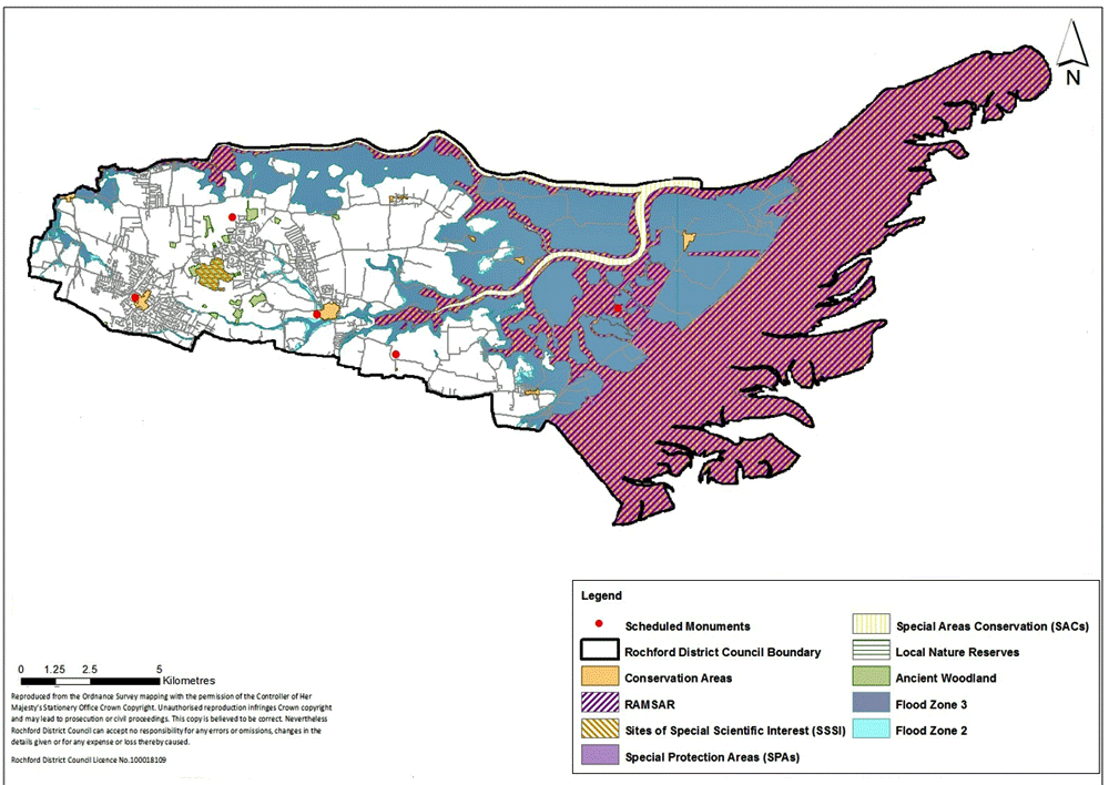
Figure 45: National and international ecological designations, indicative areas at risk of flooding (Flood Zone 2 and 3), and Conservation Areas and Scheduled Ancient Monuments.
1 www.environment-agency.gov.uk