Allocations Submission Document
(11) 1. Introduction
The Role of the Allocations Document
The Allocations Document forms an important part of the Rochford District Local Development Framework (or LDF) – a collection of documents that will set out how the District develops in the future. The Allocations Document is a Development Plan Document. It sets out how land will be allocated across the District for a range of uses.
This document provides a structure for clear, visible, consistent decision making by ensuring that land allocations for different uses are clearly set out. The Allocations Document does not just identify land for residential, educational, and employment development, sites across the District are also set out in this document for protection, including the Green Belt, Local Wildlife Sites, open spaces and the Upper Roach Valley.
Boundary allocations relating to the town centres of Rochford, Hockley and Rayleigh are also identified, where appropriate. However, the detailed land allocations for these three town centres as well as London Southend Airport and its surrounding area will be addressed within separate Area Action Plans; Hockley Area Action Plan, Rochford Area Action Plan, Rayleigh Area Action Plan and London Southend Airport and Environs Joint Area Action Plan.
Sites that were put forward for consideration as part of the Allocations Document came from a variety of sources, including those identified by Rochford District Council, those suggested to the Council by landowners, agents, developers, or members of the public, and those identified for a specific land use within the Rochford District Council Replacement Local Plan 2006.
The sites that have been identified across the District can all be seen on the Proposals Map located towards the end of this document.
The Allocations Document is structured as follows:
-
Introduction – This section sets out the context for the Allocations Document.
-
Brownfield Residential Land Allocations – This chapter establishes the approach to the allocation of sites for housing on previously developed land. This sets the site context and capacity, identifies the site boundary and outlines the design principles through a Concept Statement for the individual brownfield sites.
-
Settlement Extension Residential Land Allocations – This section identifies the sites allocated for housing on land previously allocated as Green Belt, involving an extension to the existing residential envelope. This chapter also identifies sites to be allocated for Traveller accommodation. This sets the site context and capacity, identifies the site boundary and outlines the design principles through a Concept Statement for each of these sites.
-
Existing Employment Land Allocations – This chapter sets out the existing sites allocated for employment use identified to be protected within the Core Strategy.
-
New Employment Land Allocations – This section identifies the sites allocated for employment use on land previously allocated as Green Belt. This sets the site context and capacity, identifies the site boundary and outlines the design principles through a Concept Statement for each of these sites.
-
Ecological and Landscape Allocations – This chapter identifies locally important ecological and landscape designations; Local Wildlife Sites, the Coastal Protection Belt and the Upper Roach Valley.
-
Educational Land Allocations – This section sets out the approach to the allocation of new and existing schools.
-
Open Space and Leisure Facilities Allocations – This chapter identifies new and existing areas of open space and existing leisure facilities.
-
Town Centre and Primary Shopping Area Boundary Allocations – This section establishes the town centre boundaries and primary shopping areas for Rayleigh and Rochford town centres.
-
Implementation, Delivery and Monitoring – This chapter sets out how the policies within the Allocations Document will be implemented and monitored.
-
Proposals Map – This section brings together all of the individually identified allocations of land in the previous sections of the Allocations Document, and displays these on a District-wide map. This includes the revised Green Belt boundary, which will be created as a result of the allocation of land in the previous sections of the Allocations Documents effect on the Green Belt boundary previously established through the 2006 Rochford District Replacement Local Plan.
-
Characteristics Map – This chapter includes a map showing a number of land use designations / characteristics which whilst are not allocations for the purposes of the Local Development Framework, nevertheless provide useful information relevant to planning.
Relationship with other LDF Documents
There are a number of different documents which together will set out the Development Plan for the District. The diagram below (Figure 1) shows what these documents are and how they fit together. Planning applications will be determined in accordance with the Development Plan. Development Plan Documents will set the blueprint for the future development of the District through planning policies. Supplementary Planning Documents, however, do not contain policies and as such are not part of the Development Plan. These documents will sit below the policy documents and provide additional advice and guidance, where appropriate, to assist officers in the determination of planning applications.
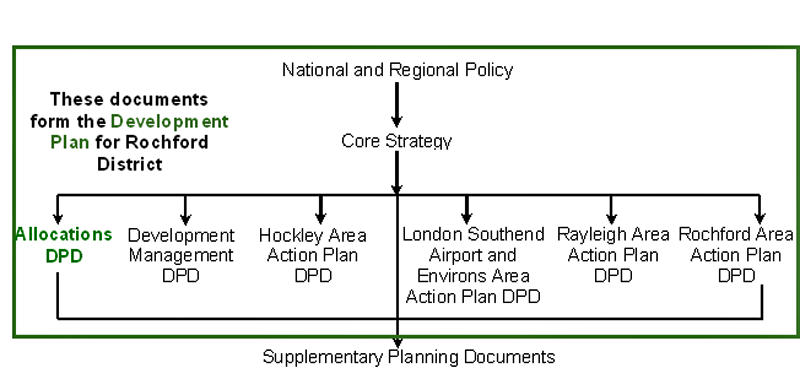
Figure 1: The Development Plan
The Core Strategy is the overarching planning policy document of the LDF, which sets out our main issues for the future and the policies which will shape the future development of the District. The Allocations Document will sit below the Core Strategy in the LDF and must conform to the approach set out in it in order to be found ‘sound’ through independent examination and to deliver our vision. The Allocations Document must not repeat the policies in the Core Strategy and should be read in conjunction with them. Therefore both these documents will be used in the determination of planning applications for the development and use of land and buildings in the District.
The other documents which will form the LDF of the District play an important role in shaping what the District will look like in the future. The Development Management DPD will set out the detailed day-to-day planning policies through which development within the District will be delivered. The four Area Actions Plans will provide policies specific to the areas they cover (the three main shopping areas, and the airport and its surrounding area). Together these documents will form the Development Plan for the District.
The Allocations Document will be subject to several stages of public consultation, which will help shape its preparation. This consultation document is the second stage in the process and has been developed having regard to our approach to future development as set out in the Core Strategy, and comments received during public consultation on the first version of the Allocations Document (the Discussion and Consultation Document) in 2010.
The Core Strategy was adopted on 13 December 2011. The Allocations Document will support and aid the delivery of the policies within the Core Strategy.
This document should be read in conjunction with the approach outlined in the Core Strategy.
The Core Strategy is divided into various sub-sections; the Allocations Document covers these sub-sections as set out below:
Table 1: Relationship between the Core Strategy and Allocations Document
| Core Strategy | Allocations |
|---|---|
| Housing | Residential land Allocations |
| Character of Place | Design of development and the historic environment are considered as part of the allocations |
| Green Belt | Green Belt land Allocations |
| Upper Roach Valley and Wallasea Island | Ecological and Landscape Allocations |
| Environmental Issues | Ecological and Landscape Allocations |
| Community Infrastructure, Leisure and Tourism | Open Space and Leisure Facilities Allocations |
| Transport | Transport and highway improvements are required as part of the allocations |
| Economic Development | Employment land Allocations |
| Retail and Town Centres | Town Centre and Primary Shopping Area Boundary Allocations |
Vision
Our vision is shared with that of the Local Strategic Partnership:
‘To make Rochford District a place which provides opportunities for the best possible quality of life for all who live, work and visit here’
To support this, we have four main corporate objectives. These are:
-
Making a difference to our people
-
Making a difference to our community
-
Making a difference to our environment
-
Making a difference to our local economy
The strategic vision for the District during the plan period is set out in the Core Strategy. The Core Strategy and Allocations Document have a key role to play in the delivery of the vision for Rochford District. For each theme of development management, the vision and objectives for that topic as determined in the Core Strategy have been set out, where appropriate. The Allocations Document will contribute to the vision and objectives in conjunction with the Core Strategy. Together, these all contribute to the overall vision for the District. The vision and objectives for the plan period have been adapted from those in the Core Strategy to reflect changing circumstances, emerging initiatives and suggestions from community involvement.
Sustainability Appraisal
The preparation of a Sustainability Appraisal is a mandatory requirement under the Planning and Compulsory Purchase Act 2004 for the production of the documents which together form the Local Development Framework. The integration of this document into the development of planning policy ensures that the wider social, environmental and economic effects of the draft policies and proposals contained within Development Plan Documents (such as the Core Strategy DPD, Development Management DPD and the Allocations DPD) are fully assessed.
The initial stage of the Allocations Document, called the Discussion and Consultation Document, was published for consultation in 2010. This document was assessed for its environmental, economic and social impacts (Sustainability Appraisal). This assessment and an analysis of the consultation responses received, as well as existing and new evidence that has emerged, have informed the development of this document. This document has also been appraised in sustainability terms.
The results of the Sustainability Appraisals, including non-technical summaries, and the Consultation Summary for each stage of the Allocations Document (combined in the Consultation Statement) are available as separate documents.
The Sustainability Appraisal, as well as the Consultation Statement, form part of the evidence base of the Local Development Framework.
Community Involvement
Community involvement is an important and integral part of the development of the Local Development Framework. The preparation of this Pre-Submission document has taken into account the findings of community involvement exercises from the various public consultation stages which have informed the development of the Core Strategy, as well as at the Discussion and Consultation version of the Allocations Document.
Relationship with Other Strategies
As stated above, the Allocations Document will have to conform to the Core Strategy. The Core Strategy has been developed having regard to a wealth of other strategies, at higher and lower tiers to the District (i.e. regional, sub-regional, county and sub-district level strategies). The Allocations Document should also take into account these other strategies, and contribute towards their delivery.
The Sustainable Community Strategy (2009) is the long-term vision for the District and sets out the priorities for improvement intended to deliver the vision. It is developed by the Local Strategic Partnership which is a partnership of local public, private and voluntary sector organisations who play a key part in the provision of services within the District.
Our Local Development Framework should aid the delivery of the Sustainable Community Strategy and act as an umbrella for all other strategies developed for the area.
The Sustainable Community Strategy identifies seven key priorities:
-
Supporting the Ageing Population
-
Fostering Greater Community Cohesion
-
Strengthening the Third Sector (voluntary sector)
-
Increasing Accessibility to Services
-
Keeping Rochford Safe
-
Encouraging Economic Development: Skills, Employment and Enterprise
-
Promoting a Greener District
The Core Strategy, as the main planning policy document of the District’s Local Development Framework, has a key role to play in delivering all of the above. The Allocations Document will address the Sustainable Community Strategy priorities primarily through aiding the delivery of the Core Strategy.
In addition to the Sustainable Community Strategy, there are a number of other strategies which influence our Local Development Framework. These are set out in paragraph 1.27 of the Rochford Core Strategy.
National planning policy in the form of the National Planning Policy Framework or NPPF, has also shaped the production of the Allocations Document.
Evidence Base
This document, where appropriate, has also drawn upon the extensive evidence base which has informed the development of the Core Strategy. The evidence base contains numerous plans, studies and strategies which support the emerging policies and proposals in the Local Development Framework. Evidence base documents particularly pertinent to the allocation of land in the District include the ‘call for sites’, the Strategic Housing Land Availability Assessment and the Sustainability Appraisal / Strategic Environmental Assessment. These and other key documents are detailed as follows:
-
Affordable Housing Viability Study (2010) assesses the viability of the affordable housing policy in the Core Strategy.
-
Annual Monitoring Reports report on a range of indicators on an annual basis since 2004.
-
Call for Sites was carried out in early 2007 and resulted in the submission of a number of sites from developers, land-owners and agents for consideration by the Council. Over 200 responses were received as part of this process, with land holdings of various sizes and uses across the whole district being put forward for consideration. These sites have then been considered against their proposed uses, in terms of size, location, constraints, sustainability, and viability.
Appendix 1 to the initial stage of the Allocations Document (the Discussion and Consultation Document) provides a detailed assessment of sites that were put forward for consideration. Please note that, due to the size of this assessment, Appendix 1 is available as a separate document.
Additional sites were submitted following the initial consultation on the document in 2010. All of the sites (a total of 225 sites were suggested) have been considered in the 2012 Site Screening Report in terms of their relationship with the Core Strategy requirements. The sites which were then screened in – those within the general locations identified in the Core Strategy for residential and employment use – were assessed in more detailed in the 2012 Detailed Residential/Employment Site Options Assessments.
-
Community Involvement carried out at each stage of the development of the Core Strategy (i.e. Issues and Options, Preferred Options, Revised Preferred Options, and Pre-Submission). Comments on the Discussion and Consultation version of the Development Management DPD were invited in March/April 2010.
-
Conservation Area Appraisals and Management Plans (2007) assess the characteristics of the District’s Conservation Areas, as well as proposing action to ensure their value is retained or enhanced.
-
Allocations Development Plan Document: Detailed Assessment of Potential Employment Sites (March 2012) assesses the options for new employment land to the west of Rayleigh and to the south of Great Wakering.
-
Allocations Development Plan Document: Detailed Assessment of Potential Additional Employment Site Options (Evidence Base Document) (September 2012) assesses the alternative options for new employment land suggested for consideration.
-
Allocations Development Plan Document: Detailed Assessment of Potential Residential Site Options (Evidence Base Document) (September 2012) assesses the options for extensions to the residential envelope in the Core Strategy general locations.
-
Allocations Development Plan Document: Site Screening Report (Evidence Base Document) (September 2012) assesses each of the sites submitted through the ‘Call for Sites’ process in terms of compliance with the Core Strategy.
-
Designing Gypsy and Traveller Sites: Good Practice Guide (2008) sets out detailed advice for the siting and designing of traveller sites.
-
Employment Land Study examines the supply and demand for various forms of employment land and compares this to the current and projected future economic profile of the District in order to determine the spatial requirements for future employment.
-
Essex and South Suffolk Shoreline Management Plan (2010) identifies the best ways to manage flood and erosion risk to people and to the developed, historic and natural environment along the Essex and South Suffolk coast. It also identifies opportunities where shoreline management can work with others to make improvements.
-
Essex County Council Development Management Policies (February 2011) provides policies relating to highways and transport infrastructure.
-
Essex Gypsy and Traveller Accommodation Assessment (2009) provides an update assessment of the accommodation needs of Gypsies and Travellers.
-
Essex Landscape Character Assessment (2003) outlines the extent of the three broad landscape character types within the District, and includes an assessment of their sensitivity to different forms of development.
-
Essex Thames Gateway Water Cycle Study – Scoping Study (2009) a sub-regional review of the existing condition of both the natural water environment and the water infrastructure which serves the population of the South Essex
-
Joint Strategic Needs Assessment (2008) details a wealth of data around health and well-being issues in Essex.
-
Local Wildlife Site Review (2007) is an assessment of existing and potential local wildlife sites to determine their importance as natural habitats.
-
Looking Back and Moving Forward – Assessing the Housing Needs of Gypsies and Travellers in Essex (2006) provides an assessment of the projected future accommodation needs for Gypsies and Travellers up until 2016.
-
Open Space Study (2009) examines the current provision and quality of a variety of open spaces throughout the District.
-
Planning and Design for Outdoor Sport and Play (2008) sets out principles for the planning and design of outdoor sport and play facilities (both children and young people).
-
Playing Pitch Strategy (2012) examines the supply and demand for playing pitches in Rochford District, in relation to a number of sports.
-
Retail and Leisure Study (2008) examines the shopping and leisure use habits of the District’s residents, and the spatial implications of these for the future development of the area.
-
Rochford Biodiversity Action Plan sets out actions and targets to enhance biodiversity in the District.
-
Rochford District Historic Environment Characterisation Project (2006) provides a wealth of evidence on the importance of the historic environment within the District and facilitates the integration of management and conservation principles within the planning process.
-
Rochford Futures Report profiles the social, economic and environmental characteristics of Rochford District at a District and Ward level.
-
Strategic Environmental Assessment Baseline Information Profile presents a plethora of secondary data about the social, physical, environmental and demographic characteristics of the District.
-
Strategic Flood Risk Assessment Level 1 & 2 Final Report (February 2011) provides a revision to the previous Thames Gateway South Essex Strategic Flood Risk Assessment report, and has been progressed following the scoping report in 2009. This is a combined Level 1 and Level 2 report, which includes a strategic overview of all potential sources of flooding which is sufficiently detailed to enable the application of the Sequential Test within the District (Level 1), and provides more detail of flood risk where there is development pressure in areas that are at Medium and High risk and to facilitate the application of the Exception Test where necessary (Level 2).
-
Strategic Housing Land Availability Assessment determines the availability, suitability and achievability of housing development sites within the District. The 2012 Strategic Housing Land Availability Assessment (SHLAA) assessed the quantum of land available for residential development. The study confirmed the capacity from extant permissions and other appropriate sites, and ascertained that there would have to be some Green Belt release in order to meet the District’s housing requirements. The SHLAA determined that there were deliverable sites within the general locations identified in the Core Strategy capable of providing the required number of dwellings.
-
Strategic Housing Market Assessment 2008 provides data on housing supply and demand at the sub-regional level. The Strategic Housing Market Assessment: Update Report 2010 provides a review of the situation in order to reflect changes to the Thames Gateway South Essex housing market in the period from October 2008 to February 2010.
-
Surface Water Management Plan 2011 sets out a co-ordinated approach to the management of surface water within south Essex (encompassing Basildon Borough, Castle Point Borough and Rochford District).
-
Sustainability Appraisals and Strategic Environmental Assessments are an integral part of the development of the planning policy documents forming the Local Development Framework. A Sustainability Appraisal was carried out at each stage in the development of the Core Strategy, assessing the social, economic and environmental impacts of proposed policies. The Sustainability Appraisals have influenced the development of the Core Strategy and thus the strategic approach to future development. This has subsequently shaped the approach of the Allocations Document.
Furthermore the findings of the Sustainability Appraisals assessing the Allocations Document, both at the Discussion and Consultation Document and Pre-Submission Document stages, have been incorporated into this document. The combined Sustainability Appraisal of the Allocations Document has informed identification of the final sites, and should be read in conjunction with the Core Strategy Sustainability Appraisal and Addendum.
-
Thames Gateway South Essex Strategic Flood Risk Assessment determined the areas at risk of flooding across the sub-region, and calculated the probability of their flooding, enabling land across the sub-region to be categorised as Flood Zone 1, 2, 3 depending on the risk.
-
Thames Gateway South Essex Strategic Flood Risk Assessment Review – Scoping Report (2009) provides a review of the Thames Gateway South Essex Strategic Flood Risk Assessment (SFRA) which was published in 2006.
-
Urban Capacity Study (2007) examines the capacity to accommodate development within the District on existing appropriate sites. This study has been superseded by the Strategic Housing Land Availability Assessment.
-
Water Cycle Study (2011) identifies any key constraints on housing and employment growth planned within Basildon Borough, Castle Point Borough and Rochford District that may be imposed by the water cycle and how these can be resolved.
National Planning Policy Framework
Presumption in Favour of Sustainable Development
When considering development proposals the Council will take a positive approach that reflects the presumption in favour of sustainable development contained in the National Planning Policy Framework. It will always work proactively with applicants jointly to find solutions which mean that proposals can be approved wherever possible, and to secure development that improves the economic, social and environmental conditions in the area.
Planning applications that accord with the policies in this Local Plan (and, where relevant, with polices in neighbourhood plans) will be approved without delay, unless material considerations indicate otherwise.
Where there are no policies relevant to the application or relevant policies are out of date at the time of making the decision then the Council will grant permission unless material considerations indicate otherwise – taking into account whether:
-
Any adverse impacts of granting permission would significantly and demonstrably outweigh the benefits, when assessed against the policies in the National Planning Policy Framework taken as a whole; or
-
Specific policies in that Framework indicate that development should be restricted.
Key Diagram
The Core Strategy sets out the broad framework for managing development in the District. A balanced approach is adopted as depicted on the Key Diagram below.
