Allocations Submission Document
(3) 2. Brownfield Residential Land Allocations
Introduction
There are a limited number of brownfield sites within the District which have the potential to contribute to the District’s housing requirements. The Core Strategy (Policy ED3) identifies existing employment land which can fulfil a portion of this housing need, and as such will no longer be protected through the planning system. Four sites – Star Lane Industrial Estate, Eldon Way/Foundry Industrial Estate, Stambridge Mills and Rawreth Industrial Estate will be reallocated for alternative uses. However, an appropriate use for these sites includes some employment generating uses.
The infrastructure and service requirements to accompany the reallocation of these existing employment sites are detailed within Appendix H1 of the Core Strategy.
(14) Policy BFR1 – Star Lane Industrial Estate, Great Wakering
Site Context:
Star Lane Industrial Estate is located towards the western end of the High Street to the east of Star Lane in Great Wakering. It comprises two areas with distinct characteristics – the northern section which is currently in use and the southern section which is a disused brickworks.
The site primarily consists of a range of industrial buildings and structures to the northern section and hardstanding to the southern section. Decontamination of the site may be required prior to development. There are existing access points onto the site from Star Lane.
Located to the east of the site is the Star Lane Pits Local Wildlife Site (R35). There is an access road along the southern boundary of the site which provides vehicular access to this Local Wildlife Site. An existing public footpath also runs along the southern boundary of the site.
Site Capacity:
The close proximity of this site to the Local Wildlife Site is an important factor in determining the appropriate density for this site. The scale and mass of the buildings currently occupying the northern section of the site would also need to be considered. Consequently a balance needs to be struck, as identified in the SHLAA (2012).
Combined, the site area of Star Lane Industrial Estate is 5.8 hectares.
The SHLAA (2012) indicates that this site has the potential to accommodate between 87 and 131 dwellings based on a calculation of 50% and 75% developable area respectively, at an estimated appropriate density of 30 dwellings per hectare. At 40 dwellings per hectare, the site has the potential to accommodate between 116 and 174 dwellings based on a calculation of 50% and 75% developable area respectively.
However, the expectation is that this site could deliver 131 dwellings as identified in the Strategic Housing Land Availability Assessment.
This site is also required to provide a range of infrastructure, services and facilities to accompany residential development:
-
Local highway capacity and infrastructure improvements
-
Public transport infrastructure improvements and service enhancements
-
Link and enhancements to local pedestrian/cycling and bridleway network
-
Sustainable drainage systems
-
Public open space
-
Play space
-
Youth facilities and community facilities
Star Lane Industrial Estate is illustrated in Figure 3.
The principles for the development of this site are set out in the Concept Statement.
Site Map:
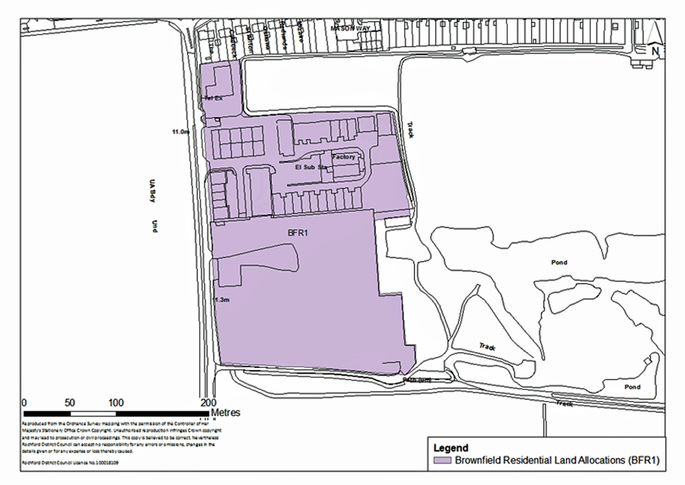
Figure 3: Star Lane Industrial Estate, Great Wakering
Concept Statement:
A minimum of 87 dwellings should be provided across the site, of which at least 30 dwellings should be set aside as affordable housing units and should be provided ‘tenure blind’. However, the expectation is that this site could deliver 131 dwellings as identified in the Strategic Housing Land Availability Assessment.
All dwellings should comply with the Lifetime Homes Standard plus a minimum of two dwellings should be built to full wheelchair accessibility standards. A Lifetime Homes and wheelchair accessibility housing statement will be required to accompany any planning application to demonstrate how the proposed development will address the 16 Lifetime Homes Standard design criteria, and show on plans how criteria 1, 3, 5, 6, 7, 10, 12, 14 and 15 will be achieved.
Compliance with the appropriate Code for Sustainable Homes standard will also be required, and a minimum of 10% of the energy should be generated by on-site renewable and low carbon sources, unless demonstrated as part of a planning application that this would be unviable.
At least 0.6 hectares of public open space should be provided across the site. This calculation of need is based on a minimum of the provision of 87 dwellings. In the event a greater number are provided, the provision of public open space should increase. This should take the form of natural/semi-natural greenspace. Amenity greenspace should also be provided across the site.
At least a local area for play (LAP) on a minimum of 0.01 hectares should be provided on the site, but developers should look to provide local equipped areas for play (LEAP) and/or neighbourhood equipped areas for play (NEAP) which require a minimum of 0.04 hectares and 0.1 hectares respectively. These areas should be well located within the development so that they are open, welcoming, safe and easily accessible from pedestrian routes, and within an appropriate walking time. The play spaces should be suitably landscaped and visible from nearby dwellings or well used pedestrian routes. In general, the design of these should follow the principles established by Fields in Trust and Play England.
The site is adjacent to a Local Wildlife Site which is located to the east. A green buffer between the development and the Local Wildlife Site should be provided to minimise disturbance along the eastern boundary. Given the proximity of the site to an area of ecological value, a Local Wildlife Site management plan should be prepared in consultation with relevant bodies such as the Council, Natural England and the Essex Wildlife Trust, given potential increased recreational pressure on the site from development.
The road to the south of the industrial estate (which is located within the Green Belt) provides access/egress to the adjacent Local Wildlife Site which would need to be considered. Development of the site should not restrict existing vehicular/pedestrian access/egress to the Local Wildlife Site. However, the potential to utilise the existing access/egress for the Local Wildlife Site (which is in the Green Belt) to enable a combined access/egress point for these development should be explored.
The relationship between this site and employment land to the south (Policy NEL3) would need to be considered, particularly in terms of potential impact on communities (avoiding the development of a ‘bad neighbour’ use), visual impact and highway network to be considered at the planning application stage. A green buffer to the south of the site should be provided, including the retention of existing vegetation on the southern side of the access road to the Local Wildlife Site.
An appropriately sized green buffer between the site to the south of the High Street (Policy SER9b) and the northern section of the industrial estate, should it not come forward prior to the development of the site, will be required. However, this should not restrict future integration of the two sites.
The loss of any trees on site or in the vicinity of the sites should be appropriately mitigated against, with the provision of replacement trees on a like-for-like basis.
Trees and hedges should be developed in garden areas along the eastern, northern and southern boundaries of the site to create a green buffer in perpetuity between development of this site and adjacent development (Policy SER9b), whilst promoting integration.
Development of the site should contribute towards the provision of local youth and community facilities. These could be provided on-site, or alternatively, take the form of financial contributions towards the development, enhancement and maintenance of existing or emerging facilities such as a Multi Use Games Area (MUGA). Each part of the site should make a proportionate contribution to the provision of facilities both on- and off-site. This would depend on the distribution of dwellings across the site.
The type of youth facilities required to accompany development should reflect the needs of the target age-group. This could take the form of indoor and / or outdoor facilities. The type of youth facilities provided should be determined in consultation with young people and agreed by at the planning application stage. Guidance on the provision of outdoor youth facilities produced by Fields in Trust should be referred to.
The above calculations of greenspace, play space and youth facilities requirements is based on 87 dwellings being provided across the site. If a greater number are provided, the provision of such facilities should increase proportionately.
The site comprises two separate components: the northern element, which is closer to the existing settlement but currently occupied by employment uses; and the southern section which is the former brickworks site and currently vacant.
Given the differing characteristics of the northern and southern sections of the site, there is potential for the southern section to be developed before the northern section. Should this occur, then a green buffer should be provided along the northern boundary of the southern section to minimise impact of the industrial use to the north, on the amenity of the residents to the south. However, the design of the development should still facilitate integration between the two sections of the site.
Similarly, should the southern section of the neighbouring industrial estate be developed prior to the northern section, the site to the south of the High Street (Policy SER9b) should be well linked and integrated into any development on the southern section in terms of providing adequate access/egress to the highway network. Pedestrian access may also be enhanced through the integration of the southern section of the industrial estate and land to the east/north east providing access onto the High Street (Policy SER9b).
Star Lane Industrial Estate (Policy BFR1) is adjacent to the site to the south of the High Street (Policy SER9b) which is allocated for residential development. The different land levels, particularly as the site to the south of the High Street is relatively low lying compared to Star Lane Industrial Estate would need to be taken into consideration at the planning application stage.
The development should facilitate links and enhancements to the local pedestrian/cycling and bridleway network. Financial contributions towards the development of the Greenway 20 to the west may also be required.
Financial contributions towards local highway capacity and infrastructure improvements and public transport infrastructure improvements and service enhancements will be required to accompany development of this site.
Development to the east of Star Lane and to the south of the High Street (Policy SER9b, BFR1 and NEL3) should be comprehensively planned to enable integration between these different land uses when they are delivered. One access/egress point onto Star Lane to serve these developments should be carefully considered at the planning application stage to avoid a proliferation of access/egress roads along Star Lane. Access/egress to the land within Policy SER9b should not go through the Local Wildlife Site but should be provided to the north east corner of the southern section of the industrial estate, if delivered prior to the northern section. Any impact on the existing footpath (from Star Lane eastwards to Alexandra Road) would also need to be considered.
A Transport Impact Assessment, including an assessment of air quality, must accompany any planning application to develop the site. This must examine the additional transport impacts that the development of this site will generate. Actions to address impacts identified through the Transport Impact Assessment must accompany the development of the site, or be provided prior to the commencement of development.
The possible dislocation between the development of the northern and southern sections of the site has the potential to impact on the range of Sustainable Drainage Systems (SUDS) developed. Attenuation SUDS of a size proportionate to the development should be used such as balancing ponds, swales, detention basins and green roofs. Appropriate SUDS should be determined in consultation with Essex County Council. A drainage strategy should be prepared for the site.
The capacity constraints in relation to Southend Waste Water Treatment Works are noted (both transfer and transmission). This will have to be overcome at the design stage in conjunction with Anglian Water.
Connection from the existing main to the new development area, to be funded by the developer, will be required and upgrades to existing network may be needed. This should be determined in consultation with Essex and Suffolk Water.
A Health Impact Assessment must be undertaken and accompany any planning applications to develop the site. Actions required to address any negative impacts identified through the Health Impact Assessment must accompany the development of the site, or be provided prior to the commencement of development.
The site is previously developed land and has been in use for a variety of employment/industrial activities. A contaminated land study should be undertaken prior to development, and decontamination undertaken as required.
The southern section is currently vacant there is potential that it could have ecological value which may need to be taken into consideration at the planning application stage.
Whilst being sensitive to the character and setting of the surrounding area, the development should not be of an overly uniform design but should be of high quality. The principles of the Essex Design Guide should be taken into account. Development towards the eastern section of the industrial estate should be of a lower density, if deemed appropriate at the planning application stage, to reflect the presence of the Local Wildlife Site.
(6) Policy BFR2 – Eldon Way/Foundry Industrial Estate, Hockley
Site Context:
Eldon Way/Foundry Industrial Estate lies within the study area of the Hockley Area Action Plan. The Core Strategy sets out the concept of redeveloping Eldon Way/Foundry Industrial Estate, however, the details of the redevelopment will be established through the preparation of the Hockley Area Action Plan.
This industrial estate is located to the west of Hockley train station to the north of Spa Road. There are two parts to this site – Eldon Way Industrial Estate which encompasses the main portion of the site and the much smaller Foundry Industrial Estate located towards the east, adjacent to the train line.
Two roads provide access to this site; Eldon Way and Station Approach. There are a range of buildings, structures and hardstanding on site. Decontamination of the site may be required prior to development.
There are two Tree Preservation Order points along the southern boundary of the site.
Site Capacity:
Although the precise detail of this site will be determined through the Hockley Area Action Plan, the SHLAA (2012) sets out potential appropriate densities given the site’s central and well-connected location. An estimation of capacity based on densities of 75 and 80 dwellings per hectare are set out below, however, this does not indicate that the site should be developed in this manner.
Combined, the site area is 4.6 hectares.
The housing trajectory originally envisaged the delivery of 150 dwellings through the Hockley Area Action Plan. However, the emerging Hockley Area Action Plan now suggests that 150 dwellings in the centre is unlikely to be delivered, although work on the Hockley Area Action Plan has identified other sites already allocated for residential, capable of delivering housing near Hockley centre in proximity to the train station.
The principles for the development of this site (identified in the Core Strategy) are set out in the Concept Statement.
Concept Statement:
Whilst the Hockley Area Action Plan will determine the detail in terms of the appropriate uses for this brownfield site, the Core Strategy (Policy RTC6) sets out the following principles for the redevelopment of the industrial estate:
-
A safe and high quality environment for residents
-
Enhanced retail offer for Hockley
-
Redevelopment of Eldon Way/Foundry for a variety of uses more appropriate for a town centre location, including residential, commercial, employment and leisure
-
A public space within a defined centre
-
Improved connectivity between retail focus and train station
-
Redevelopment of industrial uses for retail, leisure and residential development
-
Green landscaping along Main Road, Spa road and Southend Road to enhance the visual amenity
The infrastructure, services and facilities required to accompany any redevelopment of the site are established in Appendix H1 of the Core Strategy, as follows:
-
Contribution towards Hockley centre regeneration to be determined through development of Area Action Plan, including:
-
Public transport infrastructure improvements and service enhancements
-
Healthcare facilities
-
Public open space
-
Landscaping and street furniture
-
Pedestrian links between centre and train station, linking residential development to both
-
Early years and childcare facility
-
Youth and community facilities
-
Local highway capacity and infrastructure improvements, including Spa Road/Main Road junction improvements
-
The detailed policies for this site and the wider central area of Hockley, based on the above principles, will be set out in the Hockley Area Action Plan.
(6) Policy BFR3 – Stambridge Mills, Rochford
Site Context:
Stambridge Mills is a disused site formally in industrial use located to the east of Rochford. There are large, industrial buildings with considerable bulk and mass present on site.
It is situated on the banks of the river Roach which has a number of nature conservation designations. The site is detached from the existing settlement, and the constrained nature of the site means that it may be challenging to incorporate a range of house types for example.
Stambridge Mills is located within flood zone 2 and 3, and consequently both the Sequential Test and the Exceptions Test, as required by the NPPF, would have to be passed before development can take place.
The site is also in proximity to a Listed Building.
Site Capacity:
The SHLAA (2012) suggests that a high density development would be appropriate for this site due to its exceptional circumstances, i.e. the scale and mass of the buildings currently occupying it.
The SHLAA (2012) indicates that this site, which is 1.84 hectares in size, has the potential to accommodate between 41 and 50 dwellings based on a calculation of 75% and 90% developable area respectively, at an estimated appropriate density of 30 dwellings per hectare. At 60 dwellings per hectare, the site has the potential to accommodate between 83 and 100 dwellings based on a calculation of 75% and 90% developable area respectively.
However, the expectation is that this site could deliver 98 dwellings as identified in the Strategic Housing Land Availability Assessment.
Alongside residential development, the site is also required to deliver the following:
-
Flood defence
-
Public transport infrastructure improvements and service enhancements
-
Link and enhancements to local pedestrian/cycling and bridleway network
-
Sustainable drainage systems
-
Local highway capacity and infrastructure improvements
-
Public open space
-
Play space
Figure 4 shows the extent of Stambridge Mills.
The principles for the development of this site are set out in the Concept Statement.
Site Map:
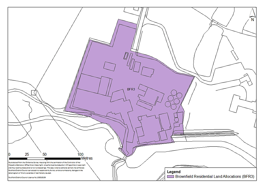
Figure 4: Stambridge Mills, Rochford
Concept Statement:
A minimum of 41 dwellings should be provided across the site, of which at least 14 dwellings should be set aside as affordable housing units and should be provided ‘tenure blind’. However, the expectation is that this site could deliver 98 dwellings as identified in the Strategic Housing Land Availability Assessment.
All dwellings should comply with the Lifetime Homes Standard plus a minimum of one dwelling should be built to full wheelchair accessibility standards. A Lifetime Homes and wheelchair accessibility housing statement will be required to accompany any planning application to demonstrate how the proposed development will address the 16 Lifetime Homes Standard design criteria, and show on plans how criteria 1, 3, 5, 6, 7, 10, 12, 14 and 15 will be achieved.
Compliance with the appropriate Code for Sustainable Homes standard will also be required, and a minimum of 10% of the energy should be generated by on-site renewable and low carbon sources, unless demonstrated as part of a planning application that this would be unviable.
A minimum of 0.3 hectares of publicly accessible natural/semi-natural greenspace and amenity greenspace should be provided on-site. At least a local area for play (LAP) on a minimum of 0.01 hectares should be provided on the site, but developers should look to provide local equipped areas for play (LEAP) and/or neighbourhood equipped areas for play (NEAP) which require a minimum of 0.04 hectares and 0.1 hectares respectively. These areas should be well located within the development so that they are open, welcoming, safe and easily accessible from pedestrian routes, and within an appropriate walking time. The play spaces should be suitably landscaped and visible from nearby dwellings or well used pedestrian routes. In general, the design of these should follow the principles established by Fields in Trust and Play England.
The above calculations of greenspace and play space requirements are based on 41 dwellings being provided on the site. If a greater number are provided, the provision of such facilities should increase proportionately.
Public transport infrastructure improvements and service enhancements and local highway capacity and infrastructure improvements should accompany development of this site.
Link and enhancements to local pedestrian/cycling and bridleway network should also be provided, with a view to enabling the integration of the site with Rochford.
A Transport Impact Assessment, including an assessment of air quality, must accompany any planning application to develop the site. This must examine the additional transport impacts that the development of this site will generate. Actions to address impacts identified through the Transport Impact Assessment must accompany the development of the site, or be provided prior to the commencement of development.
Attenuation Sustainable Drainage Systems (SUDS) of a size proportionate to the development should be used such as balancing ponds, swales, detention basins and green roofs. This could be incorporated into the greenspace provided on-site. Appropriate SUDS should be determined in consultation with Essex County Council. A drainage strategy should be prepared for the sites.
In terms of wastewater transmission, network upgrades may be required. Any issues identified should be resolved in conjunction with Anglian Water.
Connection from the existing main to the new development area, to be funded by the developer, will be required and upgrades to existing network may be needed. This should be determined in consultation with Essex and Suffolk Water.
The location of the site adjacent to the river Roach means that there are national and international nature conservation designations in proximity to the site. It is also adjacent to a Local Wildlife Site and as such a management plan for this should be provided. Additionally, any specific development coming forward should be designed such as to avoid harm to these nature conservation designations, specifically through discouraging human activity within the areas designated for their ecological value along the banks of the Roach.
Given that the site is within an area at risk of flooding, the Exceptions Test for would need to be passed, and appropriate flood defences will have to be implemented prior to any residential redevelopment.
Safe access and egress, above the 1 in 200 year flood level including allowances for climate change, must be provided from all parts of the development to an area in Flood Zone 1. A Flood Evacuation Plan should be prepared for future occupants of the site detailing access and egress routes and evacuation procedures.
A Health Impact Assessment must be undertaken and accompany any planning applications to develop the site. Actions required to address any negative impacts identified through the Health Impact Assessment must accompany the development of the site, or be provided prior to the commencement of development.
The site is also in close proximity to a grade II Listed Building (‘Broomhills, Stambridge Road, Stambridge/Rochford’) which is located to the east. Development must not adversely impact on the setting of the building, and this must be demonstrated at the planning application stage.
The loss of any trees on site or in the vicinity of the sites should be appropriately mitigated against, with the provision of replacement trees on a like-for-like basis.
The site should be appropriately landscaped. Whilst being sensitive to the character and setting of the surrounding area, the development should not be of an overly uniform design but should be of high quality. The principles of the Essex Design Guide should be taken into account.
(8) Policy BFR4 – Rawreth Industrial Estate, Rayleigh
Site Context:
Situated to the west of Rayleigh, Rawreth Industrial Estate is accessible from Rawreth Lane to the north of the site. Existing residential development is adjacent to the site to the east and south. The site boundary does not encompass the large retail building towards the northern end of the industrial estate.
There are a range of industrial buildings, structures and hardstanding on site. Decontamination of the site may be required prior to development.
There are trees subject to Preservation Order along the northern, eastern and southern boundaries and there is a Tree Preservation Order area along the western and south western boundary of the site.
Rawreth Industrial Estate is adjacent to the general location to the north of London Road and should be considered in conjunction with the site identified in this location.
Site Capacity:
This site covers an area of 6.2 hectares. It does not have any density restrictions, and so as identified in the SHLAA (2012) it could accommodate a relatively high density; it suggests between 30 and 60 dwellings per hectare.
This site has the potential to accommodate between 93 and 140 dwellings based on a calculation of 50% and 75% developable area respectively, at an estimated appropriate density of 30 dwellings per hectare. At 60 dwellings per hectare, for example, the site has the potential to accommodate between 186 and 279 dwellings based on a calculation of 50% and 75% developable area respectively.
However, the expectation is that this site could deliver 222 dwellings as identified in the Strategic Housing Land Availability Assessment.
Residential development on this site is also required to be accompanied by a range of infrastructure, services and facilities:
-
Contribution towards new primary school within North of London Road, Rayleigh residential development
-
Public transport infrastructure improvements and service enhancements
-
Link and enhancements to local pedestrian/cycling and bridleway network
-
Public open space and play space
-
Sustainable drainage systems
-
Local highway capacity and infrastructure improvements
The extent of Rawreth Industrial Estate is set out in Figure 5.
The principles for the development of this site are set out in the Concept Statement.
Site Map:
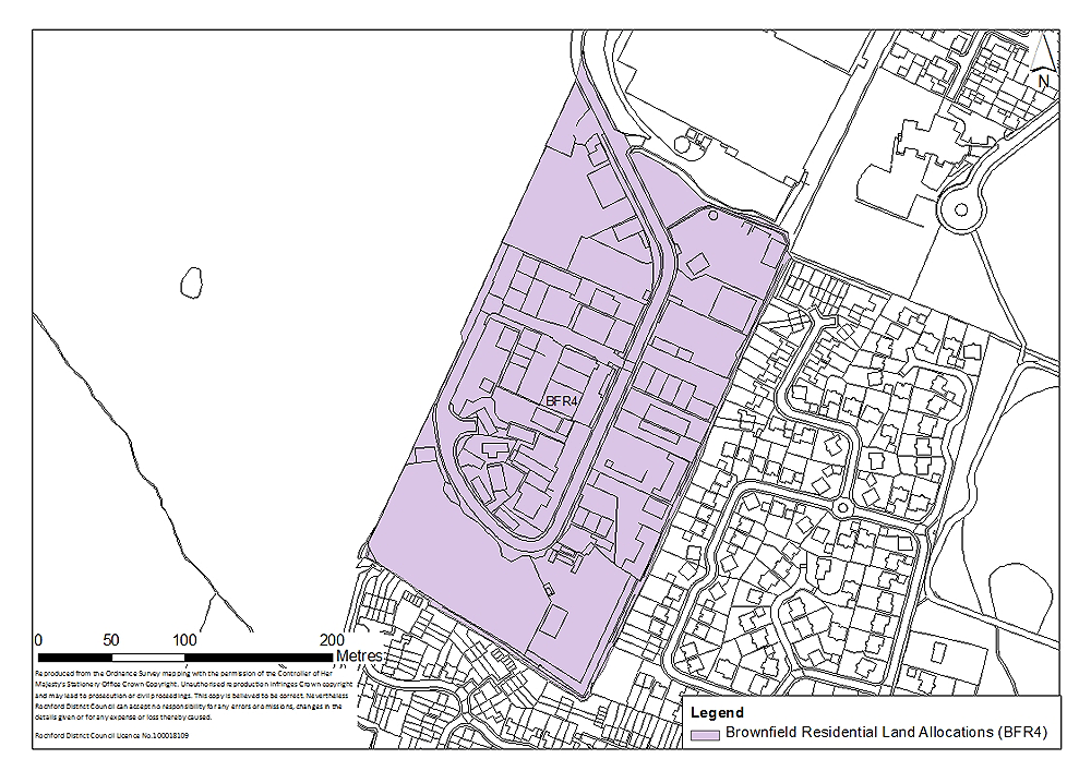
Figure 5: Rawreth Industrial Estate, Rayleigh
Concept Statement:
Development of this site should deliver a minimum of 89 dwellings, which should provide at least 31 ‘tenure blind’ affordable housing units. However, the expectation is that this site could deliver 222 dwellings as identified in the Strategic Housing Land Availability Assessment.
All dwellings should comply with the Lifetime Homes Standard plus a minimum of two dwellings should be built to full wheelchair accessibility standards. A Lifetime Homes and wheelchair accessibility housing statement will be required to accompany any planning application to demonstrate how the proposed development will address the 16 Lifetime Homes Standard design criteria, and show on plans how criteria 1, 3, 5, 6, 7, 10, 12, 14 and 15 will be achieved.
Compliance with the appropriate Code for Sustainable Homes standard will also be required, and a minimum of 10% of the energy should be generated by on-site renewable and low carbon sources, unless demonstrated as part of a planning application that this would be unviable.
There is a need to ensure that appropriate alternative employment land is in place before redevelopment of this site (see Policy NEL1 and NEL2).
Redevelopment of this site also needs to be considered within the context of residential development between Rawreth Lane and London Road (Policy SER1). Development of the site should be undertaken in a manner such as to enable future integration with residential development identified in Policy SER1 to the west of the site.
The site is previously developed land and has been in use for a variety of industrial activities. A contaminated land study should be undertaken prior to development, and decontamination undertaken as required.
Existing trees both on-site and along the boundaries of the site, particularly those with Tree Preservations Orders along the northern, eastern and southern boundaries should be retained, unless it can be demonstrated at the planning application stage that this would render development unviable/undeliverable.
The loss of any trees on site or in the vicinity of the sites should be appropriately mitigated against, with the provision of replacement trees on a like-for-like basis.
Consideration needs to be given to the integration of this site with land to the west (Policy SER1). If the industrial estate (Policy BFR4) is implemented prior to the development of land to the west, provision of a buffer between residential development and industrial uses, whilst ensuring the layout of the residential development will allow future integration with the residential redevelopment to the west. However, if the site is implemented following the redevelopment of land to the west for residential use should be integrated with new residential development on the industrial estate.
Trees and hedges should be developed in garden areas along the boundaries of the site to create a green buffer in perpetuity between new and existing development, whilst promoting integration.
Whilst being sensitive to the character and setting of the surrounding area, the development should not be of an overly uniform design but should be of high quality. The principles of the Essex Design Guide should be taken into account.
The site should accommodate a minimum of 0.6 hectares of natural/semi-natural greenspace, which should be publicly accessible and integrated into the development. This area of public open space may be provided to the south west of the site (where there is a small area at risk of flooding).
Additionally, at least 0.01 hectares of amenity greenspace should be provided on-site.
At least a local area for play (LAP) on a minimum of 0.01 hectares should be provided on the site, but developers should look to provide local equipped areas for play (LEAP) and/or neighbourhood equipped areas for play (NEAP) which require a minimum of 0.04 hectares and 0.1 hectares respectively. These areas should be well located within the development so that they are open, welcoming, safe and easily accessible from pedestrian routes, and within an appropriate walking time. The play spaces should be suitably landscaped and visible from nearby dwellings or well used pedestrian routes. In general, the design of these should follow the principles established by Fields in Trust and Play England.
The above calculations of greenspace and play space requirements are based on 89 dwellings being provided on the site. If a greater number are provided, the provision of such facilities should increase proportionately.
There is existing access/egress onto the site from Rawreth Lane, however, local highway capacity and infrastructure improvements, public transport infrastructure improvements and service enhancements will be required.
Links and enhancements for walking and cycling and the bridleway network should be developed. Financial contributions towards the development of Greenway 13 and other non-vehicular routes such as the proposed Sustrans cycle route may also be required.
A Transport Impact Assessment, including an assessment of air quality, must accompany any planning application to develop the site. This must examine the additional transport impacts that the development of this site will generate. Actions to address impacts identified through the Transport Impact Assessment must accompany the development of the site, or be provided prior to the commencement of development.
Attenuation Sustainable Drainage Systems (SUDS) of a size proportionate to the development should be used such as balancing ponds, swales, detention basins and green roofs. Appropriate SUDS should be determined in consultation with Essex County Council. A drainage strategy should be prepared for the sites.
In terms of wastewater transmission, the network should be modelled. Any issues identified should be resolved in conjunction with Anglian Water.
Connection from the existing main to the new development area, to be funded by the developer, will be required and upgrades to existing network may be needed. This should be determined in consultation with Essex and Suffolk Water.
The cumulative impact of any development to the west of Rayleigh on the grade II Listed Building to the west of the site (‘Barn approximately 40 metres east of Rawreth Hall, Rawreth’) would need to be carefully considered.
Financial contributions towards a new primary school within residential development identified in Policy SER1 would be required.
A Health Impact Assessment must be undertaken and accompany any planning applications to develop the site. Actions required to address any negative impacts identified through the Health Impact Assessment must accompany the development of the site, or be provided prior to the commencement of development.