Rayleigh Area Action Plan Submission Document
Reproduced from the Ordnance Survey mapping with the permission of the Controller of Her Majesty’s Stationery Office Crown Copyright. Unauthorised reproduction infringes Crown copyright and may lead to prosecution or civil proceedings. This copy is believed to be correct. Nevertheless Rochford District Council can accept no responsibility for any errors or omissions, changes in the details given or for any expense or loss thereby caused. Rochford District Council Licence No. 100018109
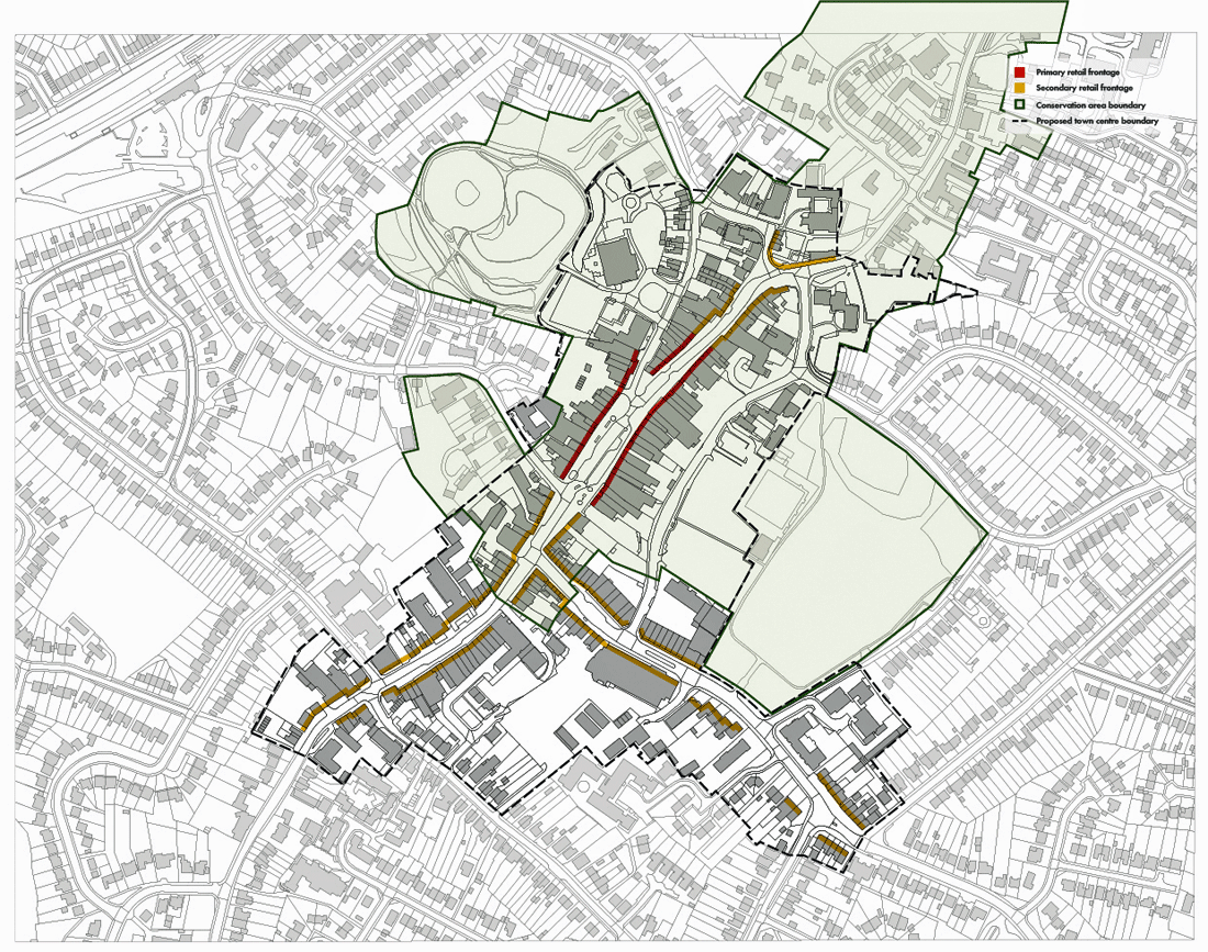
Figure 10 – Rayleigh AAP Proposals Map
(3) 4. Proposals plan, shopping frontages and sites
4.1 Rayleigh town centre boundary
Rayleigh town centre is centred on High Street. To the north, the centre extends up to the top end of London Hill. To the south, the centre extends to the Rayleigh Baptist Church site on High Street, south of Castle Road. Generally, to the west, the boundary is drawn at the rear of the commercial premises which address High Street – the centre also includes the Mill Arts and Events Centre on Bellingham Lane. On the eastern side, the centre includes both the Castle Road and Websters Way car parks. The centre extends along Eastwood Road beyond King George’s Park although does not encompass the park itself. The town centre boundary is considered appropriate and has not been altered during the preparation of this AAP. The District-wide Retail and Leisure Study makes no recommendation to review the boundary.
POLICY 2 – RETAIL DEVELOPMENT IN RAYLEIGH
Rayleigh town centre is Rochford District’s principal shopping centre. The Council will support development proposals that retain or strengthen Rayleigh’s position in the local retail hierarchy.
New retail-led development within Rayleigh town centre will be permitted where it would:
-
Maintain the predominance of retail uses in the centre, at concentrations and proportions appropriate to the relevant designated shopping area defined under Policy 3;
-
Contribute positively to the local retail character of the relevant area of the town centre, as identified under Policies 4-8; and
-
Where possible, deliver improved physical linkages along key public routes and between the core High Street and the town’s principal car parks.
POLICY 3 – RAYLEIGH’S SHOPPING FRONTAGES
Within the town centre’s primary and secondary shopping frontages, as defined on the Rayleigh AAP Proposals Map (Figure 10), proposals for A1 retail uses will be acceptable. A proposed change of use for non-retail (non-A1) purposes will be permitted where it would:
-
Not have a detrimental impact on, or undermine, the predominance of A1 uses within the centre, both within the centre as a whole and within the primary shopping frontage;
-
Not create a cluster of non-A1 uses within the same use class in a locality that undermines the retail character of the centre; and
-
Entail the provision of a non-A1 use which is considered to positively contribute to the overall offer and encourage people into the centre.
The Council will generally seek to ensure 75% of Rayleigh’s primary shopping frontage and 50% of its secondary shopping frontage is in retail (A1) use.
4.2 Retail development
Rayleigh town centre is the town’s principal shopping centre. Under Policy 2 and in line with Core Strategy Policy RTC 4 a positive stance on new retail development within the defined shopping frontages will be taken.
The proposals plan (Figure 10) defines the primary and secondary shopping frontages within Rayleigh town centre. An appropriate balance of uses is necessary to support the economic health of Rayleigh town centre, and it is essential that retail uses are supported by non-retail uses such as cafés, pubs, offices and banks.
The district-wide Retail and Leisure Study 2008 concluded that the planning strategy in place at that time in terms of the extent of primary and secondary frontages and the concentrations of A1 uses and non-A1 uses within them was appropriate and no changes were recommended. Since then, land use monitoring of the defined shopping frontages has been undertaken. This monitoring reveals that for the target proportions of A1 uses in the primary shopping frontage to be achieved, the extent of the primary frontage will need to be reviewed.
The primary shopping frontage is now consolidated around the central section of High Street between Crown Hill and Bellingham Lane. This more concentrated primary shopping area presents concentrations of A1 retail uses at the proportion sought under the policy. This review helps to strengthen the primary shopping frontage policy and in doing so helps to protect the vitality and viability of the town centre economy. The secondary shopping frontage has been extended to incorporate those areas previously identified as part of the primary shopping frontage.
The target proportions of 75% and 50% of the primary and secondary frontages in A1 retail use respectively are considered appropriate for this principal town centre. These proportions have been carried forward from the Local Plan.
Notwithstanding the need to protect A1 uses in the identified shopping frontages, an appropriate balance of uses is necessary to support the health of Rayleigh town centre, and it is essential that retail uses are supported by non-retail uses such as cafés, pubs and banks.
The Council recognises the dynamic nature of centres and the need for flexibility. The target proportions of A1 retail uses will be used as a guide and will be kept under review through town centre monitoring.
As was the case in the previous Local Plan, clusters of non A1 uses are considered to be more than two immediately adjacent non-A1 uses of the same use class. That said, a view will be taken on a case-by-case basis. The overriding objective will be to ensure the vitality and viability of the town centre is protected.
To ensure this balance the Council will not permit a cluster of any more than two immediately adjacent non-retail uses of the same use-class. More than two Sui Generis uses adjacent to one another may not necessarily be considered a cluster, provided they are distinct and different uses.
However there are uses of which the provision of additional units in Hockley centre would not be considered to positively contribute to the overall offer of the centre. Such uses include hot food takeaways (A5 uses), planning applications for which will not generally be supported.
Some land uses associated with town centre locations have the potential to raise amenity issues for nearby residents. Such uses might include, but are not necessarily limited to, those falling in Use Classes A3, A4 and A5 or other, Sui Generis uses such as night clubs. The impact of such non-retail uses on the amenity of those living within or nearby the centre will be an important consideration I determining relevant planning applications, and applicants will be expected to demonstrate how negative impacts arising from such proposals will be mitigated, if applications are to be permitted.