Rayleigh Area Action Plan Submission Document
Reproduced from the Ordnance Survey mapping with the permission of the Controller of Her Majesty’s Stationery Office Crown Copyright. Unauthorised reproduction infringes Crown copyright and may lead to prosecution or civil proceedings. This copy is believed to be correct. Nevertheless Rochford District Council can accept no responsibility for any errors or omissions, changes in the details given or for any expense or loss thereby caused. Rochford District Council Licence No. 100018109
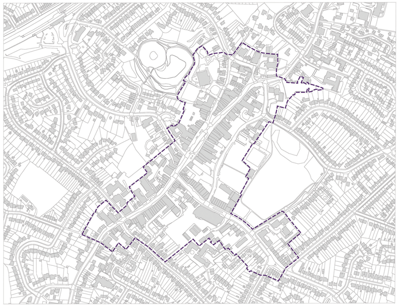
Figure 1 – Rayleigh town centre and AAP area
(4) 1. Introduction
1.1 The big picture
Rochford District Council is committed to preparing Area Action Plans (AAP) for its three main centres of Rayleigh, Rochford and Hockley. The AAPs will form part of the statutory development plan for Rochford District. This document focuses on guiding the development of Rayleigh town centre, and also considers its immediate surrounds.
The Core Strategy recognises the existing successes of Rayleigh town centre, including its role as Rochford District’s principal centre and strong retail sector, and high quality, historic environment. Although it is made clear that radical changes to the town centre are not necessary, the Core Strategy does set out the need for additional leisure uses and extra retail floorspace. It is important that the AAP provides a framework for development that will build on Rayleigh town centre’s existing strengths and allow for development that will enhance its current offer.
The AAP will, if adopted, form a part of the District’s Development Plan. Alongside the adopted Core Strategy and other key planning documents, the AAP will eventually replace the existing Replacement Local Plan (2006).
1.2 Next steps
This version of the AAP will be published and placed on deposit prior to an Examination in Public (EiP). If the AAP is found sound at the EiP, it will be adopted.
Once adopted, the AAP will be used as a framework for the development of Rayleigh and in the determination of planning applications. It will be subject to the normal processes of monitoring and review.
Any representations on this version of the Rayleigh AAP should be sent to Rochford District Council.
1.3 Working with our community
In recent years a series of community engagement and consultation exercises have been undertaken in relation to Rayleigh. These have been in support of the production of the Rayleigh AAP and the Core Strategy for the District. The AAP has been informed through its various stages by the responses received to these exercises, which have included:
- A Placecheck and letter drop, as well as additional meetings with Council Members, undertaken to inform the preparation of the Rayleigh AAP Issues and Options paper.
- Consultations on the proposals set out within the Issues and Options paper.
- A consultation on the District’s Core Strategy Submission Document that yielded feedback specifically related to Rayleigh.
Most recently a further stage of consultation was held on the planning policy framework for Rayleigh that had emerged following the Issues and Options report. This was a public exhibition, which was held between 15 and 29 January 2013. A total of 44 response questionnaires were received as a result of the consultation and the key messages were that:
- Most of those that responded agreed that the planning policy framework should seek to strengthen Rayleigh’s role as the District’s principal town centre, and that retail uses should be focussed on High Street.
- There was resistance to a retail-led redevelopment of Websters Way car park and the construction of a multi-storey car park, which was considered likely to cause visual harm, have a negative impact on openness and cause security problems.
- A number of those that responded suggested that any large-scale development, if it does take place, should be for a leisure use, such as a cinema, swimming pool or another sports facility.
Reproduced from the Ordnance Survey mapping with the permission of the Controller of Her Majesty’s Stationery Office Crown Copyright. Unauthorised reproduction infringes Crown copyright and may lead to prosecution or civil proceedings. This copy is believed to be correct. Nevertheless Rochford District Council can accept no responsibility for any errors or omissions, changes in the details given or for any expense or loss thereby caused. Rochford District Council Licence No. 100018109
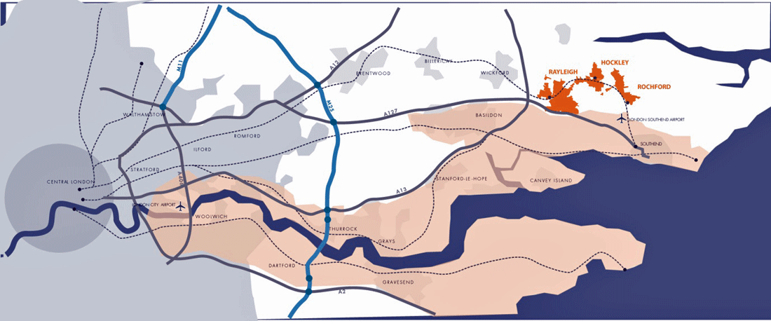
Figure 2 – Rochford’s regional context
- It was highlighted that the Council’s recent Retail and Leisure Study demonstrated that there is no need for additional convenience retail in Rayleigh and that any allocation should be for comparison retail only.
- There was support for measures that would encourage and support small, independent shops and more market traders.
- Some of those that responded expressed their concern over the impact that more economic activity in the evening might have on crime rates and the fear of crime.
- Although there was strong support for enhancements that would help to promote the town’s strong group of historic assets, there was opposition to Rayleigh Mount being used as a through route between High Street and the rail station.
- There was some support for the reduction in size of the taxi rank on High Street and its potential relocation, although some felt that the taxi rank’s current location is appropriate and that it may need to accommodate more taxis in the future.
- There were mixed views over whether High Street should be pedestrianised and if traffic calming should take place or not, though it was generally agreed that traffic flow should be improved if new development does take place.
- Many considered that there was a need to ensure that the town centre would have enough car parking to allow it to compete with other destinations, especially out-of-town shopping centres.
- It was suggested that the planning policy framework should promote bus travel as a way of increasing the number of shoppers whilst avoiding extra pressure on car parks.
1.4 Working with our partners
Rochford District Council is working closely with its partners to ensure that the strategic and cross-boundary implications of the Rayleigh AAP are being fully explored and that any discussions will feed into its positive preparation. The Localism Act 2011 sets out a ‘duty to co-operate’, which requires such a process.
The main partner in relation to the AAP is Essex County Council (ECC), in relation to its role as Highways Authority for Rochford District and much of the wider area. In particular, conversations with ECC officers have allowed for the project team to identify new or proposed developments with a significant highways impact.
1.5 The AAP area
The AAP area is the same as the existing town centre. It includes the main section of High Street, Bellingham Lane, Websters Way, and Eastwood Road, as far as Queens Road. It also includes some sections of adjoining streets and the town’s largest car park on Websters Way.
Rayleigh is Rochford District’s principal centre and the retail offer in the AAP area reflects this status. Most of the ground floor units on High Street between Eastwood Road and Hockley Road are shops; other sections of High Street, in addition to Bellingham Lane and Eastwood Road, accommodate supporting uses, such as cafés, restaurants, pubs, other leisure uses and professional services. Websters Way and, to a lesser extent, Bellingham Lane play an important role in helping to provide access, servicing and car parking for buildings located on High Street.
Rayleigh Mount immediately adjoins the AAP area and forms a group of important heritage assets at the north end of High Street, with Holy Trinity Church and Rayleigh Windmill, which are within the area. The Dutch Cottage is also just outside of the AAP area, on the south side of Crown Hill.
The rail station is situated a short journey from the town centre itself and the AAP area, and can be accessed most directly via Crown Hill. It has a closer relationship with surrounding residential development than the town centre itself.