Rayleigh Area Action Plan Submission Document
Reproduced from the Ordnance Survey mapping with the permission of the Controller of Her Majesty’s Stationery Office Crown Copyright. Unauthorised reproduction infringes Crown copyright and may lead to prosecution or civil proceedings. This copy is believed to be correct. Nevertheless Rochford District Council can accept no responsibility for any errors or omissions, changes in the details given or for any expense or loss thereby caused. Rochford District Council Licence No. 100018109
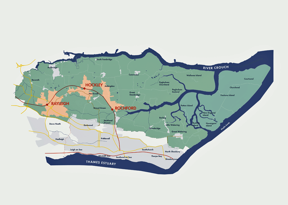
Figure 3 – Rochford’s district context
(3) 2. Rayleigh in context
This chapter sets out the planning and policy context within which the Rayleigh AAP will operate, including a review of key sections of the local planning evidence base.
2.1 Strategic location and local setting
Rayleigh is located on a peninsula bounded by the River Thames to the south, the River Crouch to the north and the North Sea to the east. It is to the north-west of Southend-on-Sea and east of Wickford and Basildon.
The town is the largest in the District and has relatively large residential areas to its south-east and north-west. Although it is closely related to other nearby residential areas within the Borough of Southend-on-Sea, it is surrounded by Metropolitan Green Belt. Within the District, Hockley and Rochford are located to the east of Rayleigh.
The Great Eastern rail connection between Southend-on-Sea and London Liverpool Street has a stop at Rayleigh and supports commuting into central London. The A127, A13 and A130 roads meet to the west of Rayleigh and provide access to the wider region, the motorway network and local attractors, including Southend-on-Sea, Basildon and Chelmsford.
2.2 Historical evolution and Conservation Area
Rayleigh grew up as a settlement at the foot of the Mount, which was the castle of Swein of Essex and mentioned in the 1086 Domesday Book. It is likely that Rayleigh was deliberately planned within the castle’s earthworks.
The town’s market dates back to before 1181, when it was first recorded, and would have traded locally produced goods such as pottery. The local economy was founded on the market. This explains the width of High Street, which was laid out to accommodate stalls; the presence of Holy Trinity Church at one end of the marketplace is also a characteristic feature.
Despite the Mount losing its military significance before the end of the 13th Century, the town spread as far as Eastwood Road in the south and the start of Hockley Road in the north during the medieval period. During the 17th and 18th Centuries, however, Rayleigh failed to prosper in the same way as other similar nearby towns located on major roads, such as Billericay and Chelmsford, and growth was relatively slow. It was not until the arrival of the Railway from London Liverpool Street in 1889 that the town attracted commuters and began to expand dramatically up until the start of the First World War. This growth resulted in farms, estates and the grounds of large house being sub-divided for development.
Following the Second World War a large number of unsympathetic developments took place, in an attempt to replace the existing smaller shops with more commercially suitable modern buildings. There was local concern at this pace of change and Rayleigh Civic Society was founded in 1963 to oppose inappropriate proposals.
Rayleigh Conservation Area was first designated in 1969 and originally included the Mount, High Street and Bellingham Lane, as well as Websters Way and other adjoining roads. It has since been revised to exclude some outlying areas, most notably the Websters Way car park and King George V Playing Fields. It is likely that the formation of the Civic Society and designation of the Conservation Area acted to prevent the wholesale replacement of Rayleigh’s historic fabric.
2.3 Policy context
The Rayleigh AAP has been produced taking into account national and local planning policy, in addition to the various studies that supplement and inform this framework. This is to ensure that the AAP provides a robust policy framework for the future development of Rayleigh.
National Planning Policy Framework
The National Planning Policy Framework (NPPF) was published in March 2012. The NPPF has a presumption in favour of sustainable development, which is expanded upon by a number of core planning principles and more detailed policies.
In particular it is noted that the NPPF (Section 2) emphasises the importance of ensuring that local planning policies support the vitality and viability of town centres, and their role at the heart of communities. Practically this means that local planning authorities should promote a diverse retail offer and adopt a town centres first approach, which requires retail, leisure and entertainment, office, and arts, culture and tourism uses to locate in centres ahead of other alternatives.
Rochford Core Strategy (2011)
Rochford District Council adopted its Core Strategy document in December 2011. This sets out the overall development strategy for the District until 2025.
The Core Strategy’s approach to centres and retail development is set out in policies RTC1 and RTC2. Respectively, these seek to strengthen and improve the retail offer of the District’s main centres, including Hockley, and direct new retail development and other main town centre uses towards these locations through a sequential, town centres first approach.
The key Core Strategy policy in relation to the AAP is Policy RTC 4. This states that Rochford District Council, with partner organisations and landowners, will produce an AAP for Rayleigh’s town centre, which retains its role as the District’s principal town centre and delivers the following:
- Improved accessibility to and within the town centre.
- A safe and high quality environment for residents and visitors.
- A predominance of retail uses, including intensification of existing retail uses, which cater for a variety of needs.
- A range of evening leisure uses.
- The promotion of the provision of community facilities, including exploration of potential locations for a healthcare centre and, if appropriate, the delivery of such a facility.
Rayleigh Area Action Plan Issues and Options report
An Issues and Options report was published for the Rayleigh Town Centre AAP in 2009. This provides an analysis of the town centre’s strengths and weaknesses and discusses a number of possible improvements for various key sites and locations. The options discussed included:
- A package of potential smaller-scale interventions, such as improvements to the public realm, alterations to building façades, the creation of better quality bus stop environments, the enhancement of gateway sites and the relocation of the existing taxi rank.
- The potential development of six key sites, with a range of options for difference scales of change from low-level improvements to major redevelopment.
- More retail space, including a new supermarket and units suitable for smaller shops.
- The potential for new developments that would create an active frontage along Websters Way, through the redevelopment of existing parking and service areas.
- The redevelopment of the existing Websters Way surface car park to provide a mix of uses and a multi-storey facility.
- Changes to the local road network and traffic circulation, with a focus on options for High Street, such as the creation of a shared space, its partial or full pedestrianisation, or the reintroduction of two-way traffic.
Emerging Allocations (2012) and Development Management (2011) documents
The Council is in the process of preparing its Allocations and Development Management documents. The Allocations document has been submitted for examination and the Development Management document, was last published as a preferred options document in December 2011 and will be updated again soon prior to submission for examination.
The Allocations document includes Policy TCB1, which defines Rayleigh’s town centre boundary and primary and secondary shopping frontages. However, the supporting text makes clear that the AAP may amend these allocations.
The Development Management document includes draft policies that deal with the development of centres. These include policies that seek to control the mix of uses, as well as the conversion of upper floors to residential accommodation.
Rayleigh Conservation Area Appraisal and Management Plan (2007)
An appraisal and management plan was produced for Rayleigh Conservation Area in 2007, to assess its character and identify any potential improvements.
The appraisal identified Rayleigh’s special character as being that of a “traditional market town which was established at the gates of a Norman castle”. It notes the exceptionally wide High Street, and the good condition of the Mount and Holy Trinity Church. However, it also highlights the negative impact of unsympathetic 20th Century development on High Street and areas of poor quality townscape on Websters Way and Bellingham Lane.
The management plan includes a number of recommendations that would improve the Conservation Area. These include enhancements to shopfronts, improvements to the streetscene and the sensitive use of architectural style where new development takes place.
2.4 Retail issues
A Retail and Leisure Study for Rochford District was produced in August 2008 to form part of the local planning policy evidence base. It identified Rayleigh as the District’s strongest town centre and demonstrated a significant future requirement for additional comparison floorspace.
Indeed, its key recommendation was that the Council adopt a supportive approach towards intensification within Rayleigh’s town centre boundaries. It was also recommended that the Council supports the development of a greater range of supporting leisure facilities, provided that these are of an appropriate scale.
2.5 Employment issues
An Employment Land Study was produced for Rochford District in September 2008. This considered the current supply and quality of, and future need and demand for, employment space within the District. It forms part of the evidence base for Rochford District Council’s local planning policies.
There are no allocated employment sites within the AAP area. However, the study considers the existing employment uses within the town centre and recommends that office uses should be encouraged given its strategic location.
2.6 Land ownership context
Freehold land ownership within the AAP area is highly fragmented. However, it is noted that the Council has control over Websters Way car park, which is a significant site on the edge of the town centre.
2.7 Property market overview
Despite general market uncertainty since the 2007 “credit crunch”, there are certainly signs of increased activity – especially in London and the South-east, where developers and investors are beginning to re-enter the market place. A number of retailers have roll-out targets which they have been unable to meet due to the lack of development activity since 2007.
Reproduced from the Ordnance Survey mapping with the permission of the Controller of Her Majesty’s Stationery Office Crown Copyright. Unauthorised reproduction infringes Crown copyright and may lead to prosecution or civil proceedings. This copy is believed to be correct. Nevertheless Rochford District Council can accept no responsibility for any errors or omissions, changes in the details given or for any expense or loss thereby caused. Rochford District Council Licence No. 100018109
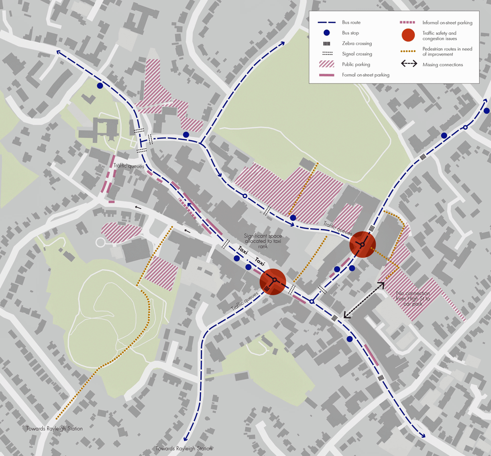
Figure 4 – Movement issues in Rayleigh
However, such requirements are focussed on a select number of towns and both size and demographic profile of catchment populations are of paramount importance.
Rayleigh town centre is the largest shopping destination in Rochford District and qualitatively has a distinctive local identity and individuality with a good range of smaller independent and specialist retailers and national multiple retailers.
The headline findings from a comprehensive review of Rayleigh’s property market were that:
- Rayleigh is successful as a town centre and appears to have withstood the recession relatively well.
- Improvements to the public realm would assist in attracting new investment and stimulating occupier demand.
- A number of the larger sites that were previously considered as development opportunities are either no longer available for development or would be prohibitively expensive to deliver in the current economic climate.
- There may be an opportunity for further infill development as buildings and properties come to the end of their economic life and such opportunities should be taken to reinforce the character of the town and add to the varied mix.
- There is a limited town centre office market, typified by low rental values and, as such, new office development is unlikely to come forward in the short term without cross subsidy from high value uses or public sector funding support.
2.8 Movement issues
Rayleigh town centre is located at the intersection of four main vehicle routes: the A129 London Road/Crown Hill in the west, the B1013 Hockley Road in the north, the A1015 Eastwood Road in the east, and the A129 High Street towards Hadleigh and A127 dual-carriageway in the south.
The town itself developed along High Street, where most of its retail frontage is currently concentrated. Websters Way was originally constructed as part of a one-way gyratory system around the town centre, but has since reverted back to two-way working. High Street remains one-way northbound, and much of the traffic uses Websters Way to access the main town centre car park and retail servicing areas. As a result, Websters Way and the junctions at either end are often congested and the conditions are decidedly poor, with the backs of retail premises forming the western edge of the street and surface parking forming a large portion of the eastern street edge.
There is also evidence of queuing into the Websters Way car park and at the junctions of the High Street with Eastwood Road and with Crown Hill. The latter being on the main route towards the station and heavily trafficked.
A range of short and long term parking is provided in and near to the town centre. The railway station has approximately 610 long-stay parking spaces spread over two connected car parking areas, and a 38 space short-stay car park adjacent to the station building. There are a number of short (less than four hours) and mixed-stay car parks spread around the town core, of which the most substantial and anecdotally well used is the Websters Way car park with 347 spaces. Castle Road Car Park (behind the Somerfield store) has 148 mixed-stay spaces. At the Windmill and The Mill Arts and Events Centre there is a 53 space short-stay car park and another 68 space mixed-stay car park. To the east of the town adjacent to the Council Civic Suite is a 65 space mixed-stay car park.
An extensive bus network operates in Rayleigh with the wider sub-regional service structure gravitating to Southend-on-Sea. Many bus routes start and end at Rayleigh rail station, making this an important interchange point for the town, with rail services terminating at London Liverpool Street (42 minutes) and Southend Victoria (18 minutes). In addition, there are four key stops in the town core that provide access to all bus services passing through Rayleigh.
Walking is provided for through the publicly accessible street network. At many of the junctions in the town centre and along High Street, guardrails and bollards create barriers to movement on foot and divert pedestrians away from direct crossings and desire lines, such as at the junction of the High Street and Crown Hill. In particular, High Street’s bus stop and taxi rank dominate and require pedestrians to modify their routes accordingly.
Minor walking improvements could be delivered in the form of a redesigned taxi rank, the removal of pedestrian guard railings and general decluttering. The main walking route from the station to the town core is via Crown Hill, although this is steep with narrow footways in places and accommodates high volumes of traffic, and should therefore be a focus for improvement. Websters Way also has a significant section without a footway that needs to be resolved.
There is no information on current signed or advisory cycle routes in the town and no national cycle routes pass through Rayleigh. There are also no notable on-road facilities. However, some cycle stands are provided on High Street. The best approach to improve cycling in the town would be to manage traffic speeds and focus on the provision of appropriately located cycle racks at the station and High Street.
2.9 The Sustainability Appraisal
The Rayleigh AAP has been subject to a Sustainability Appraisal (SA) incorporating Strategic Environmental Assessment (SEA), as required by the European SEA Directive, UK planning legislation and the NPPF. SA seeks to promote sustainable development through the integration of environmental, social and economic considerations in the preparation of planning documents.
A Scoping Report was prepared and published in September 2012 to help ensure that the SA covered key sustainability issues relevant to Rayleigh town centre. This information was sent to statutory consultees for comment. Options proposed in the Rayleigh AAP Issues and Options report, which included alternatives for a number of issues and different sites, were then subject to SA in February 2013. This was sent to statutory consultees and wider stakeholders for consultation from 27 February to 10 April 2013. The findings of the SA have been balanced against consultation feedback and helped to inform the policy options selected in this version of the AAP.
Generally the SA found that the higher the level of intervention proposed, the more positive the effects are likely to be against SA objectives relating to communities, housing, the economy and townscape. However, the redevelopment of unsympathetic buildings, particularly in large blocks, also adds an element of uncertainty. Although higher level intervention has the potential for negative effects on a number of SA objectives in the short-term during construction, it is considered that suitable mitigation measures are available at the project level to address adverse effects.
The movement of traffic through the town centre is a key sustainability issue. The SA found that options which sought the full or partial pedestrianisation of the High Street would only shift current transport issues elsewhere within the AAP area. The option that sought to work within the existing network and provide improvements to pedestrian crossings at roundabouts and improved capacity at junctions was considered to have the potential for the greatest benefits compared to the others, as it will not shift transport issues elsewhere in the area and will not increase the levels of traffic along the High Street.
The Council will continue to assess the AAP, including any changes, through the SA and will document this process.