Rayleigh Area Action Plan Submission Document
(4) 3. A framework for a better Rayleigh
3.1 What makes for a sustainable Rayleigh?
Rayleigh is an established town and a sustainable location for homes, shops, jobs, leisure and other services and facilities. The AAP seeks to ensure that a positive planning policy framework that protects this function is put in place. It recognises that sustainable development must be delivered in a joined-up fashion, with economic, social and environmental benefits being sought concurrently. In this context, the following factors are considered important:
Provision to meet shopping needs locally and within the District – Rayleigh is Rochford District’s main town centre and has a successful mix of shops. Demand for additional retail floorspace and supporting leisure facilities, to help meet shopping needs locally and across the wider-District, should be addressed. Other supporting uses should also be encouraged to help increase the attractiveness of the town centre’s offer and improve vitality.
Excellent public realm – There are a number of attractive places, spaces and buildings within Rayleigh’s town centre. These should be further enhanced, with a particular focus on the main part of High Street, as well as weaker areas on Bellingham Lane and Websters Way.
Conservation of historic assets and local character – Rayleigh has a number of important heritage assets, including Rayleigh Mount, Holy Trinity Church, Rayleigh Windmill and the Dutch Cottage. All new development should respect and enhance these assets and their settings, as well as the positive aspects of the town’s local character.
A high quality natural environment – Rayleigh benefits from being surrounded by the Metropolitan Green Belt, which prevents urban sprawl, but also allows local people access to significant areas of high quality, open space. This open space should be safeguarded through the efficient use of previously developed sites within the settlement’s existing boundaries.
Good accessibility – Rayleigh is well connected to other centres within the District, south-east Essex and the wider-region through road, rail and bus links. Improvements should be made to local walking routes, bus stops and the road network to help increase the level of accessibility to, through and within the town centre.
The AAP is a planning policy document that, primarily, seeks to assist in the management of changes and developments in Rayleigh town centre. Therefore, whilst its remit is limited, its reach is wide. Alongside the Core Strategy and other key policy documents, the AAP will help to attract and encourage new investment and co-ordinate change.
3.2 Vision and objectives
The future development of Rayleigh should strengthen the town’s position as Rochford District’s main centre, improve the environment and accessibility, and have a positive impact on the town’s heritage assets.
The AAP sets a vision for the town’s future based on an understanding of the unique context that drives change and development in Rayleigh. It translates this vision into implementation objectives, policies and guidance that will act as a robust framework for delivery.
The vision for Rayleigh is:
Rayleigh will continue to be recognised as the District’s main centre. By 2025, the town centre’s retail and leisure offer will be improved through the provision of additional retail floorspace, as well as accommodation for complementary uses, such as leisure facilities, offices and homes. Further environmental enhancements will create a high quality public realm, encourage investment and ensure that the town centre is highly accessible by foot, public transport and private motor vehicle. All new development will help to enhance the town centre’s historic setting and respect its existing character, including that of nearby suburban, low-density neighbourhoods.
Reproduced from the Ordnance Survey mapping with the permission of the Controller of Her Majesty’s Stationery Office Crown Copyright. Unauthorised reproduction infringes Crown copyright and may lead to prosecution or civil proceedings. This copy is believed to be correct. Nevertheless Rochford District Council can accept no responsibility for any errors or omissions, changes in the details given or for any expense or loss thereby caused. Rochford District Council Licence No. 100018109
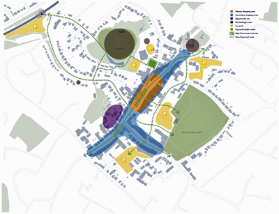
Figure 5 – Rayleigh AAP framework plan
The four key objectives that support this vision and are vital in its delivery are:
1) Strengthening Rayleigh’s role as Rochford District’s principal town centre.
Rayleigh is the most important town centre in Rochford District for shopping. It is clear that this current position could be strengthened by the provision of new accommodation, which should be suitable for both large national retailers and small independent shops. A greater range of leisure facilities and other complementary uses, including dwellings and offices, on more peripheral sites would also increase Rayleigh’s vitality.
2) Improving accessibility for all
The rail station is some distance from High Street, and walking routes from the main car parks to High Street and the main section of the shopping frontage could be improved. There are opportunities to strengthen the linkages between these areas, improve the arrival experience for visitors to the town and make some positive changes to the road network.
3) Making the most of historic assets
Rayleigh has a number of significant historic assets that are on the edge of or adjacent to the existing town centre. Principal among these is Rayleigh Mount, the site of a motte and bailey castle; Holy Trinity Church, Rayleigh Windmill and the Dutch Cottage are also important. Opportunities exist to create better connections between these assets and the town centre.
4) Delivering public realm improvements
The quality of the public realm within Rayleigh town centre is generally good. However, there are a number of opportunities to make small-scale improvements.
3.3 Arriving at a framework
Rayleigh’s existing condition was analysed through the 2009 Issues and Options report, which was prepared to inform the AAP. Some contextual changes took place between 2009 and the January 2013 consultation on the Council’s emerging preferred development framework. The most important changes were:
-
A tougher economic climate – the current economic climate is significantly more challenging than it was at the beginning of the AAP process.
-
The emergence of new priorities – a number of organisations, including Essex Police, have reviewed their property portfolios and informed the Council that land previously believed to be available for redevelopment is now included in their future plans.
-
Healthcare reform – the government has changed the way in which the NHS’s budget is managed and it is no longer clear that there is potential for a new healthcare centre in Rayleigh.
Following the January 2013 consultation the Council considered all of the feedback that was received to help refine the preferred development framework further. The AAP sets out a framework that responds to the contextual changes and previous stages of analysis and consultation.
Reproduced from the Ordnance Survey mapping with the permission of the Controller of Her Majesty’s Stationery Office Crown Copyright. Unauthorised reproduction infringes Crown copyright and may lead to prosecution or civil proceedings. This copy is believed to be correct. Nevertheless Rochford District Council can accept no responsibility for any errors or omissions, changes in the details given or for any expense or loss thereby caused. Rochford District Council Licence No. 100018109
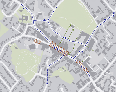
Figure 6 – Rayleigh AAP movement framework
POLICY 1 – RAYLEIGH AREA ACTION PLAN FRAMEWORK
New opportunities for retail development or other town centre uses together, supported by or contributing to appropriate town centre environmental improvements, will help to strengthen the town’s role as Rochford District’s principal town centre.
Development within the Rayleigh AAP area should contribute towards the delivery of the spatial framework as shown in Figure 5. Key elements of this framework are:
-
A consolidated and strengthened primary retail core along High Street;
-
Opportunities for new and intensified retail and other mixed-use development as sites become available;
-
The promotion of appropriate proportions and concentrations of uses other than A1 including A2-5, leisure, cultural and community uses, particularly in locations outside the primary retail core, including Bellingham Lane and Eastwood Road;
-
New and improved routes within the AAP area and linking the centre with the railway station and the surrounding area; and
-
New and improved public realm and environmental improvements throughout the centre as identified on the spatial framework.
The spatial framework for Rayleigh is summarised in Figure 5 which provides a broad indication of where development and change could take place.
The Council’s primary objective for Rayleigh is to protect and enhance its role as Rochford District’s principal town centre. This will be dependent on the emergence of high quality proposals for new retail, leisure, cultural, community and mixed-use development, enhanced connections with nearby and adjoining areas, and an improved public realm.
The AAP sets out further policies that are intended to guide high quality development that is in accordance with its vision, objectives and framework. These policies are based around an understanding of the centre’s character areas and seek to build on Rayleigh’s existing local character.
3.4 The movement framework
The movement framework outlined in Figure 6 identifies a series of key junctions throughout Rayleigh which would benefit from investment and improvement. The Council will continue to work with Essex County Council to agree the priorities for these improvements and more fully assess the issues they present and opportunities available to address them.
Table 1 below provides an overview of these improvements and a headline estimate of the resources this might require.
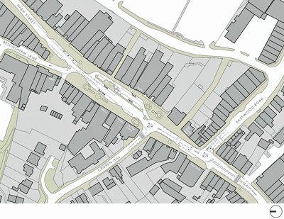
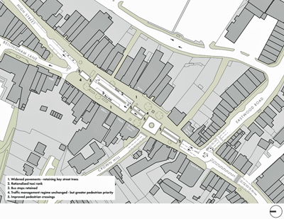
In terms of delivering public realm improvements to the town centre, the Rayleigh Framework identifies the opportunity for improvements to the central section of High Street, which is currently dominated by the taxi rank. The local taxi services provide shoppers with an important local service, but there is an opportunity to deliver greater pedestrian priority in this central and high profile location. Figure 7 provides an overview of the existing conditions in this central area and Figure 8 puts forward a potential framework for improvements. The ideas put forward would, subject to funding being identified, need to be developed and refined with the Highway Authority, local traders and other stakeholders. However, they provide a framework for a major initial phase of environmental improvements – with the potential to continue further improvements of this type within adjacent areas.
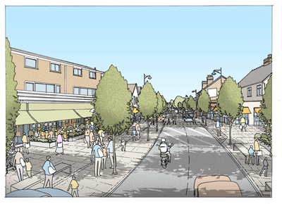
In the same spirit, Figure 9 provides an artist’s impression of the potential for environmental improvements to the High Street area outside the Library.
Reproduced from the Ordnance Survey mapping with the permission of the Controller of Her Majesty’s Stationery Office Crown Copyright. Unauthorised reproduction infringes Crown copyright and may lead to prosecution or civil proceedings. This copy is believed to be correct. Nevertheless Rochford District Council can accept no responsibility for any errors or omissions, changes in the details given or for any expense or loss thereby caused. Rochford District Council Licence No. 100018109
Figure 7 – Central High Street – existing condition
Reproduced from the Ordnance Survey mapping with the permission of the Controller of Her Majesty’s Stationery Office Crown Copyright. Unauthorised reproduction infringes Crown copyright and may lead to prosecution or civil proceedings. This copy is believed to be correct. Nevertheless Rochford District Council can accept no responsibility for any errors or omissions, changes in the details given or for any expense or loss thereby caused. Rochford District Council Licence No. 100018109
Figure 8 – Central High Street – potential improvement framework
Figure 9 –High Street south looking north from outside the Library – artist’s impression illustrating the potential benefits of pavement widening, new street trees and shop front improvements
(3) Table 1 – Major environmental improvements and highways schemes
| Environmental improvement / highways scheme | Lead partner | Other partners | Estimated cost | Potential funding stream(s) | Comments | Justification |
|---|---|---|---|---|---|---|
| High Street – Central Area (Boots Lagoon and Crown Hill junction) | ECC | Rochford District Council / developers | £1,000,000 - £1,250,000 | Pooled financial contributions / ECC budget | Consolidation of taxi stand to one row only (accommodating up to 8 vehicles) to allow for widened footways. Removal of formal pedestrian crossings and replacement with a greater number of informal crossing points along key desire lines. The creation of a notional central reserve to aid informal crossings, visually narrowing the carriageway to slow traffic. Shared space treatment of junction with Crown Hill. Footway repaving, landscaping and lighting enhancement. | A significant proportion of public space in the core of town centre is allocated as carriageway for a taxi standing area. Space is required for occasional market use. Pedestrian crossing opportunities are limited by taxi parking / circulation space and configuration of junctions. Formal signalised and zebra crossings are offset from key desire lines requiring extensive guardrailing. The arrangement of formal crossings causes localised congestion, queuing and speeding. |
| High Street – South 1 | ECC | Rochford District Council / developers | £600,000 - £800,000 | Pooled financial contributions / ECC budget | The extension of the High Street improvement scheme to incorporate areas to the south including the junction with Eastwood Road. | Formal crossings are offset from key desire lines requiring extensive guardrailing. The arrangement of formal crossings causes localised congestion, queuing and speeding. |
| High Street – South 2 | ECC | Rochford District Council / developers | £500,000 - £700,000 | Pooled financial contributions / ECC budget | The extension of High Street improvement scheme to incorporate areas further south including the junction with Castle Road. | Formal crossings are offset from key desire lines requiring extensive guardrailing. The arrangement of formal crossings causes localised congestion, queuing and speeding. |
| High Street – North | ECC | Rochford District Council / developers | £500,000 - £700,000 | Pooled financial contributions / ECC budget | The extension of the High Street improvement scheme to incorporate areas to the north. | Formal crossings are offset from key desire lines requiring extensive guardrailing. The arrangement of formal crossings causes localised congestion, queuing and speeding. |
| Eastwood Road | ECC | Rochford District Council / developers | £600,000 - £800,000 | Pooled financial contributions / ECC budget | The extension of the High Street improvement scheme along Eastwood Road, including the junction with Websters Way. | Formal crossings are offset from key desire lines requiring extensive guardrailing. The arrangement of formal crossings causes localised congestion, queuing and speeding. |
| New and enhanced pedestrian / cycle links | ECC | Rochford District Council / developers | £150,000 - £200,000 | Pooled financial contributions / ECC budget | The enhancement of pedestrian and cycle links across the town centre, for example improved mid-block links between High Street and Websters Way, between Eastwood Road and Castle Road car park, and to the station via Crown Hill. | To improve environmental quality and safety, and encourage walking and cycling for local journeys around the town. |
Note: The broad budget estimates given are based on general experience of similar scheme costs rather than any professional cost advice related to specific proposals. For public realm improvement schemes a general rate of £300/m² has been applied to the scheme area, which would allow for resurfacing with high quality materials. These figures are indicative only

