Rayleigh Area Action Plan Submission Document
Reproduced from the Ordnance Survey mapping with the permission of the Controller of Her Majesty’s Stationery Office Crown Copyright. Unauthorised reproduction infringes Crown copyright and may lead to prosecution or civil proceedings. This copy is believed to be correct. Nevertheless Rochford District Council can accept no responsibility for any errors or omissions, changes in the details given or for any expense or loss thereby caused. Rochford District Council Licence No. 100018109
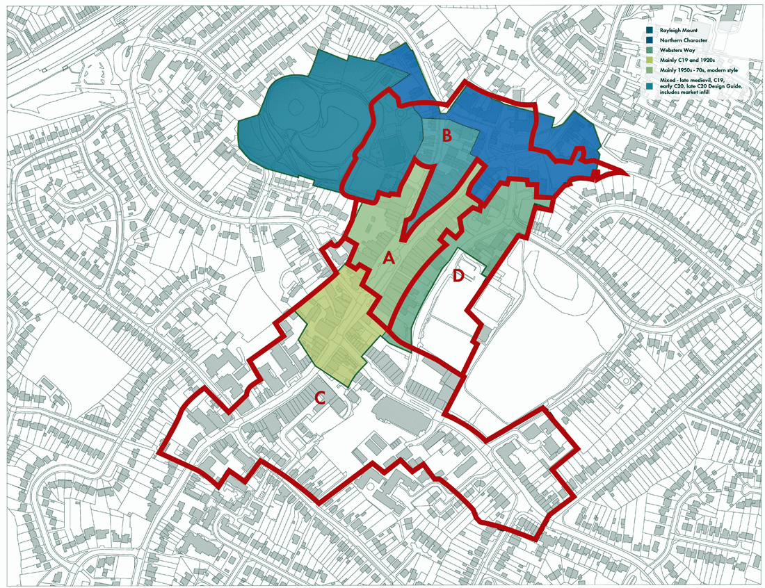
Figure 11 – Character areas
5. Rayleigh’s character areas
The central thrust of the AAP is to ensure that the historic character of the centre is protected and, where possible, enhanced. To help achieve this, and in support of the existing controls and guidance provided through the designation of the Rayleigh conservation area together with its associated appraisal and management plan, a character area approach has been developed.
For the purposes of this AAP, four character areas have been identified. These have been carefully drawn to take full account of the character areas identified in the conservation area appraisal and have been drawn to ensure comprehensive coverage of the AAP area. These do not replace the character areas set out in the conservation area character appraisal, where more detail can be found.
Policy 4 defines the four AAP character areas and provides overarching and town-wide policy guidance which will be relevant to all applications for development across the town. This is followed by a planning policy for each individual identified area.
(1) POLICY 4 – RAYLEIGH’S CHARACTER AREAS
Development will have regard to Rayleigh town centre’s identified character areas as defined in Figure 11 and the important role that each of these play in helping to make Rayleigh a successful place. Guiding principles for these areas are outlined under Policies 5, 6, 7 and 8. Where these policies contain principles that specify environmental enhancements, development should either incorporate or contribute towards these improvements.
There are principles that are important in respect of development in all four of the character areas; development should either incorporate or contribute towards the specified schemes. The principles are:
-
Public realm interventions should include the replacement of poor quality paving, the removal of street clutter, the improvement of the lighting for pedestrian routes, and the planting of native street trees;
-
Enhanced cycle parking facilities should be provided at suitable locations throughout the centre;
-
Bus facilities should be upgraded, with improvements including better shelters and increased seating provision; and
-
New and improved pedestrian signage should be introduced for key destinations and attractions, including the rail station, the town centre, the Mount, the Windmill, Holy Trinity Church and the Dutch Cottage.
The character areas identified in this AAP are informed directly by those defined in the Rayleigh Conservation Area Appraisal and Management Plan. However, taken together, the AAP character areas cover the entire AAP area, including the area to the south of the town centre not covered by the conservation area.
The appraisal and management plan provides detailed analysis of the town’s heritage assets and an account of the evolution of the town and the major events in its development. Rayleigh’s built character is one of its key assets and proposals for new development must ensure that the setting of heritage assets and, more generally, the character of the conservation area as a whole is conserved or enhanced.
Public realm, route and junction improvements as identified in Rayleigh’s Strategic and Movement Frameworks (Figures 5 and 6 respectively) are a priority and the Council will seek to secure contributions to these improvements as relevant development proposals come forward.
The local bus network is a town-wide resource which plays an important role in ensuring local people have access to sustainable, accessible modes of public transport. The Council will continue to work with partners at Essex County Council and the bus operators to keep the bus network– its routes, timetables and supporting infrastructure – under review.
Town centre signage plays a key role in helping visitors with way-finding. This in turn helps to support local businesses. Fingerposts contribute to the quality of the arrival experience and new street furniture should respond positively to the historic townscape character.
POLICY 5 – CHARACTER AREA A: CENTRAL HIGH STREET
Development in the Central High Street area will help to protect and improve Rayleigh’s position as the District’s principal retail centre. Retail (A1) uses will be supported by a high quality public realm and excellent links to the rest of the town centre and the wider surrounding area.
The following principles are important:
-
Development will respond positively to local townscape character, key elements of which include:
-
A strong building line at the back edge of pavement;
-
Town centre, predominantly A1 retail, uses at ground floor level;
-
Prevailing building heights of 3 storeys; and
-
Principal points of access to ground and upper floors positioned to address the High Street directly.
-
-
In accordance with Policy 3, shopping frontages should be predominately A1 in use;
-
Development will be acceptable where it would lead to the creation of additional A1 use floorspace which would strengthen the retail function and character of the town centre;
-
Public realm enhancements should be focused on the creation of a new public space at the centre of the High Street and include the rationalisation and reduction in size of the existing taxi rank; and
-
Pedestrian links within the AAP area, including those between the central High Street area and the Websters Way car park, and across Rayleigh, including to the rail station, should be strengthened.
The central High Street area is the core of the town centre and a location that has undergone significant redevelopment since the 1950s. Despite this period of growth and investment, the structure of the town – with the very wide High Street acting as an informal market square – has remained intact. Redevelopment has, however, underpinned the town’s retail growth with new developments catering more efficiently with modern day retail requirements. The Retail and Leisure Study identified demand for more comparison retail floorspace in the town centre. Improving the efficiency of floorspace and floorplates in this central, primary, area is likely to play a significant role in meeting any such demand.
Whilst the individual buildings are generally not in themselves special, the central High Street area benefits from a good quality townscape, with buildings generally respecting the prevailing 3 storey scale.
The taxi rank arrangement dominates the southern side of the street and, whilst shoppers benefit from the convenience this provides – as is the case with the bus stops opposite - there is scope for rationalisation of this current arrangement to give greater priority and more space to pedestrians.
Pedestrian connections to the town’s principal public car park are important. Access is currently provided by two pedestrian lanes between High Street and Websters Way – one adjacent to the Spread Eagle Pub, and Ernie Lane which is adjacent to Barclays Bank. Improving these connections is a priority for the town. In particular, there is scope to improve the lane adjacent to the Spread Eagle pub which would benefit from resurfacing and new lighting. This space has the potential to host temporary pop-up shops/market stalls.
The street’s mature trees, mostly plane, contribute significantly to local townscape character.
POLICY 6 – CHARACTER AREA B: HIGH STREET NORTH AND BELLINGHAM LANE
Development in the High Street North and Bellingham Lane area will support the retail function of the central High Street area, primarily through the provision of complementary uses, including leisure, cultural and community facilities – many of which contribute positively to the evening and night time economy. The character of this area is underpinned by a number of important heritage and leisure/cultural assets and civic uses.
The Council will support development in the High Street North and Bellingham Lane area that would protect and enhance its existing character, with a particular emphasis on its role supporting the central High Street area and the need to respect the setting of its key heritage assets. The following principles are important:
-
Development will respond positively to local townscape character, key elements of which include:
-
High quality historic townscape;
-
Town centre uses at ground floor level;
-
Prevailing building heights of 2 and 3 storeys – with taller prominent landmark buildings; and
-
An urban morphology characterised by fine grain development benefitting from rich and varied traditional building detailing and materials.
-
-
In accordance with Policy 3, shopping frontages should be in a mix of retail (A1) and other appropriate town centre uses, including leisure, cultural, community facilities and uses that contribute to the evening and night time economy;
-
Development will be acceptable where it would lead to the creation of additional floorspace for appropriate town centre uses that support the main retail function of the central High Street area;
-
The development of building backs will be acceptable where this would not have an undue negative impact on the operation of units fronting the High Street;
-
Development in the area should, where possible, seek to deliver improvements in the townscape and environmental quality of the Bellingham Lane area – including the opportunities to improve the public space in front of The Mill Arts and Events Centre; and
-
Pedestrian links across Rayleigh, including to the Mount, should be strengthened.
Views north along High Street are terminated by the prominent Holy Trinity Church, part of which are thought to date from the 12th century although most of the fabric is 15th century. The Church and its grounds together with the northern part of High Street is the most historic part of the centre and benefits from a finer urban grain.
Complementing the setting of the church, the area is characterised by its civic and cultural uses: the Council offices, the Windmill and its sensory gardens, the Mill Arts and Events Centre and the National Trust’s Rayleigh Mount. This cluster of town assets – both heritage and cultural – could anchor improvements in the provision of new leisure-based uses in the town centre, the need and opportunity for which was identified in the Retail and Leisure Study.
The northern part of High Street has developed a supporting role to the adjacent primary shopping frontage, with higher proportions of cafes and restaurants. This has informed the review of the shopping frontages during the preparation of this AAP.
Bellingham Lane is more varied in character and would benefit from sensitive redevelopment as sites become available.
There is a particular opportunity to improve the open space which acts as the entrance to The Mill. Whilst performing an important car parking function, the space and circulation around it is car dominated and would benefit from environmental improvements. The Conservation Area Appraisal noted that “The area around Mill Hall is poorly defined with an inadequate sense of enclosure”.
POLICY 7 – CHARACTER AREA C: HIGH STREET SOUTH AND EASTWOOD ROAD
Development in the High Street south and Eastwood Road area will support the retail function of the central High Street area, with an emphasis on the provision of secondary retailing and complementary uses, including service and office uses and community facilities. The area is well served by public parking which supports nearby convenience retailing.
The Council will support development in the High Street south and Eastwood Road area that would protect and enhance its existing character, with an emphasis on its role supporting the central High Street area. The following principles are important:
-
Development will respond positively to local townscape character, key elements of which include:
-
A more coarse grain of development – more suited to accommodating larger floor-plates;
-
Town centre uses at ground floor level; and
-
Prevailing building heights of 3 storeys.
-
-
In accordance with Policy 3, shopping frontages should be in a mix of retail (A1) and other appropriate town centre uses, including leisure and community facilities;
-
Development will be acceptable where it would lead to the creation of additional floorspace for appropriate town centre uses that support the main retail function of the central High Street area. The area is considered the most appropriate location for additional convenience retail floorspace;
-
Pedestrian links within the AAP area, including those between the High Street south and Eastwood Road area and the Castle Road car park, should be strengthened; and
-
Development should not result in an overall loss of public parking in this area which plays a critical role in supporting the vitality and viability of the businesses in the town centre.
This lower part of the High Street and Eastwood Road play a secondary and supporting role to the core town centre. Shopping frontages have been reviewed and, generally, the areas previously identified as primary shopping frontage along High Street and along the northern end of Eastwood Road are now identified as secondary shopping frontage. This change has a number of benefits. Firstly, it will help make the town more resilient to the weak prevailing economic conditions by providing a more clearly defined and defensible primary shopping frontage. Secondly, the change should help to minimise the potential number of vacancies in this, more vulnerable, part of the town centre. Thirdly, the change helps respond to the Retail and Leisure Study’s call for “a greater range of leisure service uses” by providing a more flexible planning framework for these key streets.
The Library provides a key community facility and will play an important role in generating footfall for this secondary location. There may be potential to deliver environmental improvements in this part of High Street which would improve the setting of the retail and other uses and would help to encourage more people to use the area. Figure 9 provides an artist’s impression of improvements that could be delivered.
The area is particularly well served by public car parks. Castle Road car park serves the area directly and the Websters Way car park is only a short walk away. Improving the quality of the pedestrian links between these car parks and the surrounding shopping streets is a priority.
The town’s largest food store is located along Eastwood Road, served by a limited dedicated car park but also benefitting from direct pedestrian access to Castle Road car park. Much of this wider area has been redeveloped for larger, more modern retail requirements. When compared with the central area and the upper High Street area, the quality of the townscape is not as high and the grain of development is less fine. For these reasons, the area is considered potentially appropriate for new larger format – including convenience – retail floorspace.
The Dairy Crest site on the corner of High Street and Crown Hill is a busy depot site and a going concern. The current occupiers have confirmed that they have no plans to relocate in the short to medium term. However, the current use is one not normally found in town centres and it is considered that in the longer term – potentially beyond this plan period – the site may have the potential for mixed use redevelopment.
POLICY 8 – CHARACTER AREA D: WEBSTERS WAY
Development in the Websters Way area will support the retail function of the central High Street area, foremost through the provision of car parking and servicing areas. The role of Websters Way itself, which takes service and through traffic away from High Street, will also be protected.
The Council will support improvements to Websters Way through development which introduces buildings which directly address this key route whilst not undermining the role that it plays in providing car parking and servicing for the central High Street area. The following principles are important:
-
Development will be acceptable where it would lead to the creation of additional floorspace for appropriate town centre uses that support the main retail function of the central High Street area;
-
The development of building backs will be acceptable where this would not have an undue negative impact on the operation of units fronting the High Street, the safety and operation of Websters Way or the levels of town centre car parking;
-
Opportunities to make better use of and deliver environmental improvements to the lanes between Websters Way and High Street will be supported. In particular, the lane alongside The Spread Eagle Pub has the potential to provide flexible space for temporary and pop-up retail stalls and events;
-
Pedestrian links within the AAP area, including those between the central High Street area and the Websters Way car park, and across Rayleigh, including to King George V Playing Fields, should be strengthened; and
-
Development should not result in an overall loss of public parking in this area which plays a critical role in supporting the vitality and viability of the businesses in the town centre.
Websters Way performs a critical role for the town centre. It successfully takes through traffic out of the primary shopping area and diverts it around the town. This inevitably leads to Websters Way being a busy road.
Access and egress to and from the town’s largest and most central public car park is also taken directly from Websters Way. The road therefore plays a critical role in supporting the economy of the town.
The north side of Websters Way presents a disjointed frontage and is primary used as the service access to commercial High Street premises. Some units however, such as the Rayleigh Lanes shopping centre, successfully manage to present an active address to both the High Street and Websters Way. Development seeking to take advantage of creating active frontage on to Websters Way will be supported and encouraged by the Council so long as the principal parking and servicing functions of Websters Way are not undermined.
Pedestrian connections between the car park and High Street are critically important for the local economy. Ernie Lane and the route adjacent to the Spread Eagle pub are very important in this regard and opportunities to improve their environmental condition – through better lighting, associated crossing points, and surface treatment – will continue to be considered in ongoing dialogue with relevant partners and stakeholders. The route alongside the Spread Eagle Pub is seen as a particular opportunity for improvement as set out in the AAP’s movement framework above. The pedestrian links across the car park towards the King George’s Park and the Town Council facilities is also an important consideration is changes were to come forward which directly affected the car park.