Rochford Town Centre Area Action Plan - Issues and Options
2 THE ISSUES
INTRODUCTION
2.1 In preparing this consultation document, we gathered information and initial ideas from the pubic via the Council's website and through a Placecheck Initiative where members of the Citizens Panel were invited to participate in a workshop event to explore issues and opportunities for the town centre. The feedback from these exercises has helped to provide ideas set out in this document, and inform the suggested vision and strategy for Rochford Town Centre. The main points raised are presented in the sections below.
(1) WHAT YOU TOLD US
Interactive web-based consultation
(3) 2.2 The web based consultation highlighted a number of key points which are summarised below:
- There were varying views on whether or not the Market Square should be pedestrianised. Those against felt it would negatively affect retail and encourage anti social behaviour and those in favour felt that it would create a better atmosphere and safer environment.
- There was a suggestion for a war memorial / other kind of memorial in the Market Square.
- There were suggestions for a cafe / bar in the Market Square.
- It was stated that there should be crossings near to Market Square to make pedestrian movement easier.
- Measures should be taken to ensure that the town centre is still used for shopping (even if Tesco and Sainsbury were to move into the area) and to promote local business. One suggestion was to stop charging for car parking in order to encourage people to continue to park in the town centre (rather than use the inevitable free parking at the supermarkets).
- There were suggestions for a landmark development over the Spar store at the eastern end of the Square.
- It was stated that more entertainment and leisure facilities are needed (particularly for under 18s).
- It was stated that more affordable housing is needed.
- It was stated that the Green Belt should be protected.
- It was stated that there should be shelter at bus stops and the position of the bus stops should be better thought through.
- There were concerns over speeding in all four streets of the town centre and the dominance of vehicles (and suggestions for better signage).
- Better signage was suggested for around the one way system to make the town centre more legible.
- There were many remarks about keeping the historic character of Rochford intact.
Placecheck Initiative
(1) 2.3 The Placecheck event was held to help inform ideas and options for future change and improvement in the town centre of Rochford, ensuring that the views and opinions of local residents help generate these options. Placecheck is a method of assessing the qualities of a place, showing what improvements are needed, and focussing people on working together to achieve them. Placecheck asks questions about the processes of change and the potential for improving the area physically (more details of the Placecheck process can be found in Appendix B). The findings are summarised in the table below.
Table 1: Summary of Placecheck consultation responses
| Questions | Comments |
| What do you like about Rochford? |
- Historic Buildings - Local Character - The Market - Variety of local shops - Reservoir and Green Space - New development when viewed from station exit |
| What do you dislike about Rochford? |
- Too many retirement homes - unsold: is there a need for so many? - Unattractive arrival experience into the town (but see comment above) - High-speed of traffic on all town centre streets, but mainly on North Street - Buses on West Street cause traffic delays - Somerfield development has generated HGV movement in town centre - Change has been incremental and un-coordinated rather than planned - Lack of community facilities (and anti-social behaviour of youths due to lack of facilities) - Unsafe at night - Difficult to cross road outside Council Offices - Narrow pavements on West Street - Spar building very unattractive - Public lavatories feel unsafe - Virgin Active facility expensive to hire - Concern that local shops will close due to competition from new larger food stores |
| What can be changed / improved? |
- New buildings should be in-keeping with the character of the town - More youth and other community facilities are needed - Need better signage/local information, especially for car parking - Historic walks could be introduced to make Rochford a destination for people - Need affordable housing, particularly for young - Introduction of an evening economy, including a new restaurant in the Market Square - Extend offer in Market, with stalls on different days (Farmers Market / French Market) - Market Square could potentially be pedestrianised - Short-stay parking could be moved to Back Lane car park, with dedicated spaces closest to the Square and long-stay parking closest to station - More legible and direct link from the station into the town centre - Needs an overall plan for future change - Improve access to green spaces: improve links across Bradley Way - Improve lighting and safety of car parks - Events are needed to instill and promote civic pride - better street cleaning and recycling facilities needed - Earlier buses to serve the station - Better interchange with the station needed |
(1) URBAN DESIGN ANALYSIS
(1) 2.4 To properly understand how the town centre works we have undertaken a survey and analysis in terms of physical development, scale, character, legibility and permeability. This has been based upon the seven objectives of urban design as established through the government guidance document: 'By Design, Urban Design in the Planning System: Towards Better Practice'. The seven objectives of urban design area:
-
Character: A place with its own identity;
- To promote character in townscape and landscape by responding to and reinforcing locally distinctive patterns of development, landscape and culture
-
Continuity and Enclosure: A place where public and
private spaces are clearly distinguished;
- To promote the continuity of street frontages and the enclosure of space by development which clearly defines private and public areas
-
Quality of the Public realm: A place with
attractive and successful outdoor spaces;
- To promote public spaces and routes that are attractive, safe, uncluttered and work effectively for all in society, including disabled and elderly people
-
Ease of movement: A place that is easy to get to
and move through;
- To promote accessibility and local permeability by making places that connect with each other and are easy to move through, putting people before traffic and integrating land uses and transport
-
Legibility: A place that has a clear image and is
easy to understand;
- To promote legibility through development that provides recognisable routes, intersections and landmarks to help people find their way around
-
Adaptability: A place that can change
easily;
- To promote adaptability through development that can respond to changing social, technological and economic conditions
-
Diversity: A place with variety and
choice.
- To promote diversity and choice through a mix of compatible developments and uses that work together to create viable places that respond to local needs
2.5 In addition to national guidance we have also taken into account the advice in the Essex Design Guide. Originally published in the early 1970s, the Guide was updated in 1997 and again in 2005. It provides guidance for designing within the context of market towns and for lower density schemes. The latest version also provides links to the new Urban Place Supplement (UPS).
(1) 2.6 The UPS provides a design framework for the delivery of compact, mixed-use sustainable urban development. The guidance emphasises design quality while ensuring the improvement of infrastructure and the sustainability of existing urban places. The UPS is being adopted as a supplementary planning document by most district and borough councils in Essex. The urban design analysis undertaken as part of this baseline report is thus mindful of the advice contained within both the Essex Design Guide and UPS.
(1) 2.7 This analysis is summarised in the table below, with more detail provided in subsequent text and diagrams.
| Rochford Market Square |
Table 2: Summary urban design assessment of Rochford town centre
| Urban Design Objective | Analysis |
| Character |
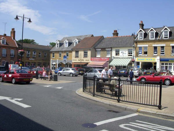
Rochford's Town Centre is defined by its historic character. The built form is of a fine grain and relatively small, intimate and human scale. It has a very high intrinsic quality. The Market Square is at the heart of the town and surrounded, in the main, by attractive buildings looking onto it. The town has evolved on the traditional cruciform pattern of streets, which come together at Horners Corner to the east of the Market Square |
| Continuity and Enclosure |
Most streets and spaces are fronted and overlooked with development. However, there are a number of 'exposed' backs. This mainly affects the properties along Back Lane and South Street, where the urban fabric is broken down by the existence of the large surface car park. |
| Quality of the Public Realm |
The Market Square is the focal point of the town centre and primary public space. This is however enclosed to the east by an unsympathetic retail unit that presents a visual barrier and unattractive blank facade to North Street. The surrounding countryside encroaches into the town, although Bradley Way forms a barrier between this and town centre activities. |
| Ease of Movement |
Rochford is a small and compact centre that is easy to navigate by foot. However, given its historic nature, many streets and pavements are narrow. The one-way system also makes for some difficult crossing points, particularly at the junction of North, South, East and West Streets. To the north of the town centre there are few connecting routes. |
| Legibility |
The historic structure and topography of Rochford enliven the experience of the town centre. Local views, landmarks and buildings enable the area and its constituent parts to be easily understood. |
| Adaptability |
In general, the built form has stood the test of time, with uses locating within the historic fabric. The reuse of the Freight House and the former Boiler House demonstrate this adaptability. However, newer developments may now be needed to accommodate modern business requirements. |
| Diversity |
The town centre comprises a good mix of uses, including retail, residential, civic and community uses within a relatively small catchment area. The new superstore has strengthened the convenience retail offer, although this could be better integrated with the town centre. |
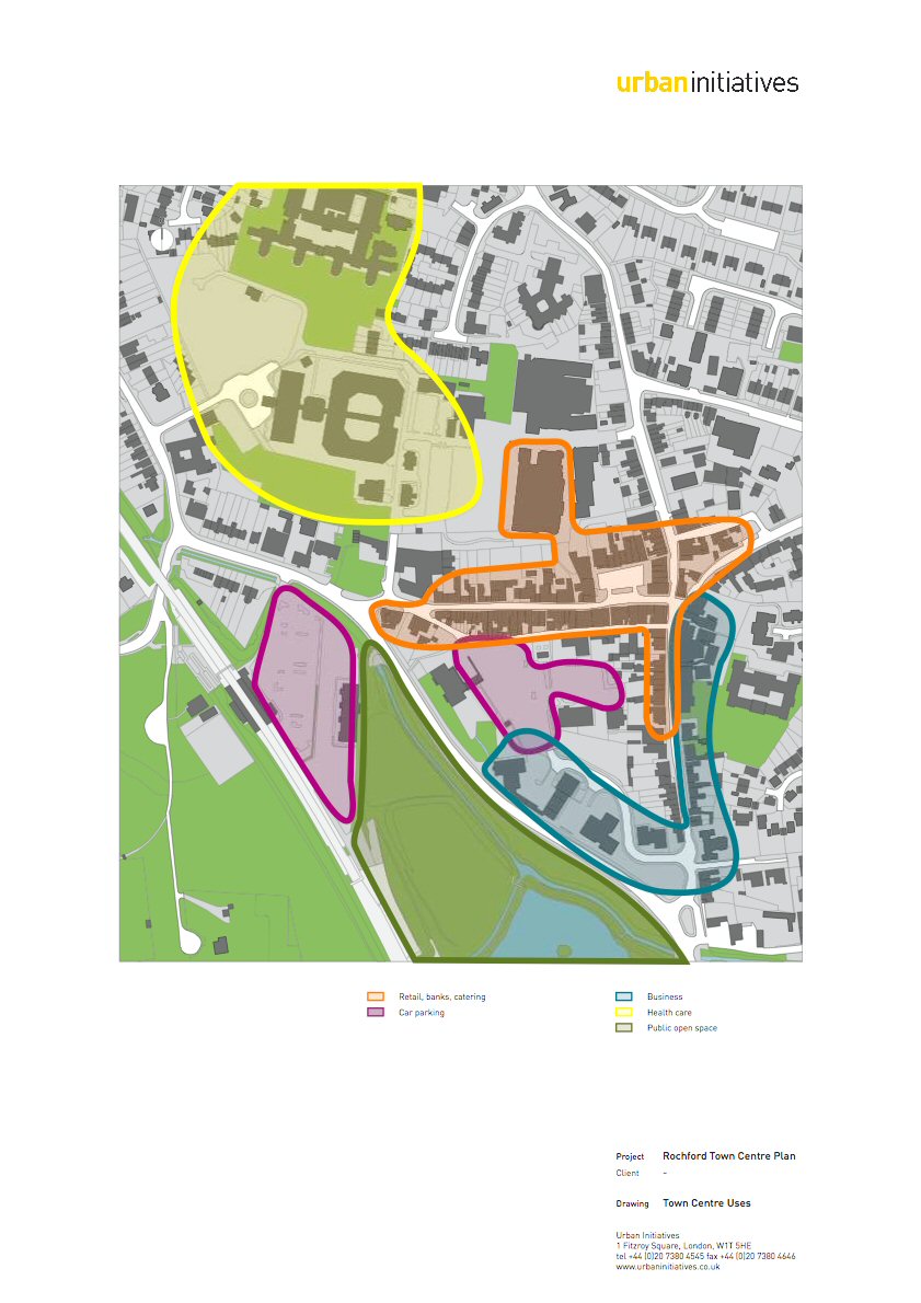
(1) LAND USES
2.8 The primary town centre uses and activities in Rochford are located along West Street, connecting the station with the Market Square. A smaller number of units turn the corner into both South and North Streets. This main area of activity has recently been expanded by the development of the new Somerfield store to the north of the centre. This is however, a little disconnected from the Market Square which is at the heart of the town.
2.9 Light industrial uses are focused around Union Lane off West Street. Of particular prominence is a garage on the corner of Union Lane and West Street, which sits between the traditional core retail along West Street and the former garage site opposite the station. Business and other commercial units, including the Council Offices, are located along South Street and Locks Hill, adjacent to Bradley Way. Those along South Street have made use of the historic building stock, whereas those adjacent to Bradley Way occupy more recent purpose-built development. This may limit the potential for adaptability and change in the long-term.
2.10 Sandwiched between the main retail core and the commercial uses is the Back Lane car park. In the context of Rochford Town Centre, this is a relatively land hungry resource. Public car parking is also located nearby at the railway station and there is also a large car park available for users of the Freight House. Opportunities may exist to explore how these facilities can be rationalised in order to make more efficient use of the land.
2.11 Other important uses include health and community activities to the north west of the town centre. Direct, safe and convenient links between these and other uses are essential to the pattern of movement in the town centre. Elsewhere, residential uses are dominant. The residential stock comprises a mixture of period housing and modern apartments. The most significant residential development within Rochford is Roche Close, by Barratt Homes. Roche Close is situated immediately to the west of North Street and is accessible from the Market Square and North Street. The scheme comprises over 100 new apartments, a supermarket with underground car parking, retail accommodation, and a library.
Figure 1: Broad land use plan
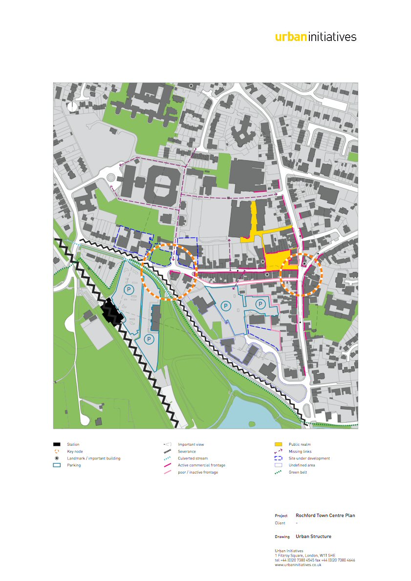
(1) FORM AND STRUCTURE
2.12 The historic development of Rochford has resulted in a fine grain of development, with intimate spaces of a good human scale enclosed, in the main, by active building frontages. However, this grain breaks down in a number of places. Notably, the Back Lane car park exposes a large number of backs to properties on Back Lane and South Street. In general, this whole area is poorly defined, with little relationship or coherence between the main town centre core, the car park and commercial uses along Bradley Way. The uses along Bradley Way present an unassuming 'front door' to the town and give little clue as to the quality of the town centre. This might be addressed through redevelopment and landscaping, including the possible reopening of the culvert stream running along the front of the railway station car park.
(2) 2.13 The other main area that suffers from poor quality frontage is to the east of the Market Square, where the retail unit occupied by Spar presents an unsympathetic response to West and North Streets. This contrasts with the high intrinsic quality of buildings and spaces at this important node point at the heart of the town.
(1) 2.14 The junction of Bradley Way and West Street also acts as an important node, linking the town centre with the railway station. West Street, which runs between these two nodal points, is thus central to the overall structure and success of the town. Reinforcing the quality of this route will help enhance and strengthen the town centre. Despite the town's fine grain, there are a number of missing links, associated primarily with the land take of the town's hospital and related health facilities. Opportunities may exist to stitch the different elements of the town together.
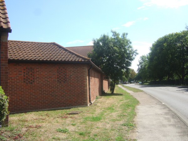
| View along Bradley Way |
Figure 2: Form and structure
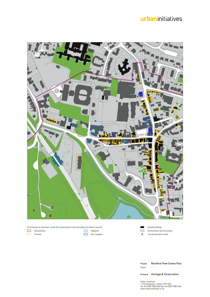
(2) CONSERVATION AND HERITAGE
(2) 2.15 For the purposes of this study a thorough understanding of the historic context is essential to understand the area's special qualities and the reasons why it has been designated as a Conservation Area. A full understanding will ensure that any solution is derived from these special qualities thereby enhancing its local distinctiveness. All of Rochford Town Centre is a Conservation Area, designated in 1969 and later extended. In 2007 Rochford District Council produced a Conservation Area Appraisal, which sets out and explains the special characteristics of the area. It is accompanied by a Management Plan that sets out measures to preserve or enhance the character or appearance of the area. The key elements of these documents will need to be reflected in any solutions brought forward.
(2) 2.16 Generally the special character of Rochford Town Centre is comprised of the inter-relationship of the following elements:
- A well preserved market town centred on a cross roads
- A collection of historic buildings of high architectural quality many of which are listed
- A characteristic street plan comprising axial roads, infilled market, Back Lane and irregular frontages all of which derive from its medieval origins
- Narrow streets with slight curvature forming discrete units. Buildings at the back edge of pavements e.g. North and West Street
- Picturesque historic core of mostly 18th and 19th century rows of low level cottages of brick and weatherboarding, one and a half imposing brick town houses notably evident on South Street and each end of West Street
- Twentieth century suburban development on the outer edges of mixed character
- Infilled market place on triangle of land with buildings grouped together on small plots
- Twentieth century institutional buildings such as the hospital to the north west
- Just outside the study area are large areas of open space, St Andrews Church (Grade II*) and the old manorial centre of Rochford Hall, a 16th century Tudor mansion house and Scheduled Ancient Monument
- Limited public open space in the town centre
- Mix of uses notably, residential (North Street. West Street, South Street and East street), Retail (West Street, part of North Street and Market Square), Offices (South Street, Market Square and West Street), public buildings including a primary school and places of worship
- Landmark buildings notably the old Rochford Hospital boiler house
- Characteristic landscape setting on the rising ground above the River Roach with South Street climbing the gently rising side of the river valley levelling out at the cross roads and the main streets
- Characteristic views up South Street towards the main road junctions adjacent to the town centre
- Selective specimen trees
(2) 2.17 The appraisal document also provides information on the types of materials and colours that should be used and it identifies, through a Management Plan, a number of measures to enhance the special characteristics of the town centre. These will feed through into proposals that are developed for the area. We do not repeat all the measures here, but flag up those of importance for this study which include:
- Improving the relationship of the church with the town centre
- Station car park improvements including refurbishment of buildings and west access
- Improve the pedestrian environment at busy junctions
- Reduce street clutter generally and rationalisation of street furniture
- Provide pedestrian access to open space near Bradley Way
- Improve the pedestrian environment at Back Lane and Old Ship Lane
- Alleviate the problem of queuing cars at the Market Square i.e. restrict car access
- Improvements to the Market Square
- Preserve historic spaces and pedestrian links where they survive
- Tree planting in car parks
- On street car park restrictions e.g. Weir Pond Road and East Street
- Landscape improvements to Old Ship Car Park
2.18 The need to ensure that any proposals derive from and respond to the context is well established. An analysis of the Conservation Area clearly flags up issues that are consistent with and build on those concluded from other parts of the study. The special qualities that are identified will need to be reflected in the solutions put forward.
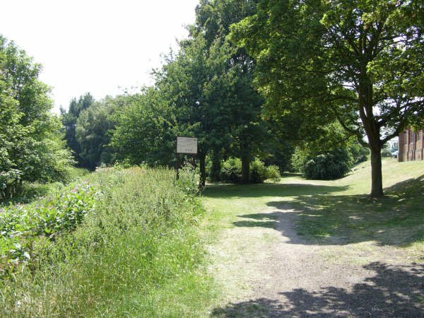
| Rochford reservoir |
Figure 3: Heritage and Conservation
TOPOGRAPHY
2.19 The local topography of Rochford makes a strong contribution to the character and identity of the town. The Market Square and junction of North, South, East and West Streets are the town's natural high points. Local views exist along these streets, the eye being led up and around streets and spaces, terminating on buildings and local features. The attractiveness of these views is enhanced by the intrinsic quality of the built form.
2.20 The railway station is also on a high point, with the station car park sloping up to the railway line. This means that the visitor is afforded interesting long distance views of the town and its roofscape upon arrival at the station.
(1) 2.21 The topography here also presents an opportunity for the town centre. On the one hand, views can be maximised to enhance the quality of the town. On the other hand, it might be possible to explore how new buildings can be structured to make better use of the topography. The railway station car park is a prime opportunity. Here, the topography could potentially be used to create a structured car park, incorporating an enhanced arrival space outside the station and improved frontage along West Street and Bradley Way.
| Rochford Station car park |
STREET NETWORK / MANAGEMENT
Existing Network of Streets
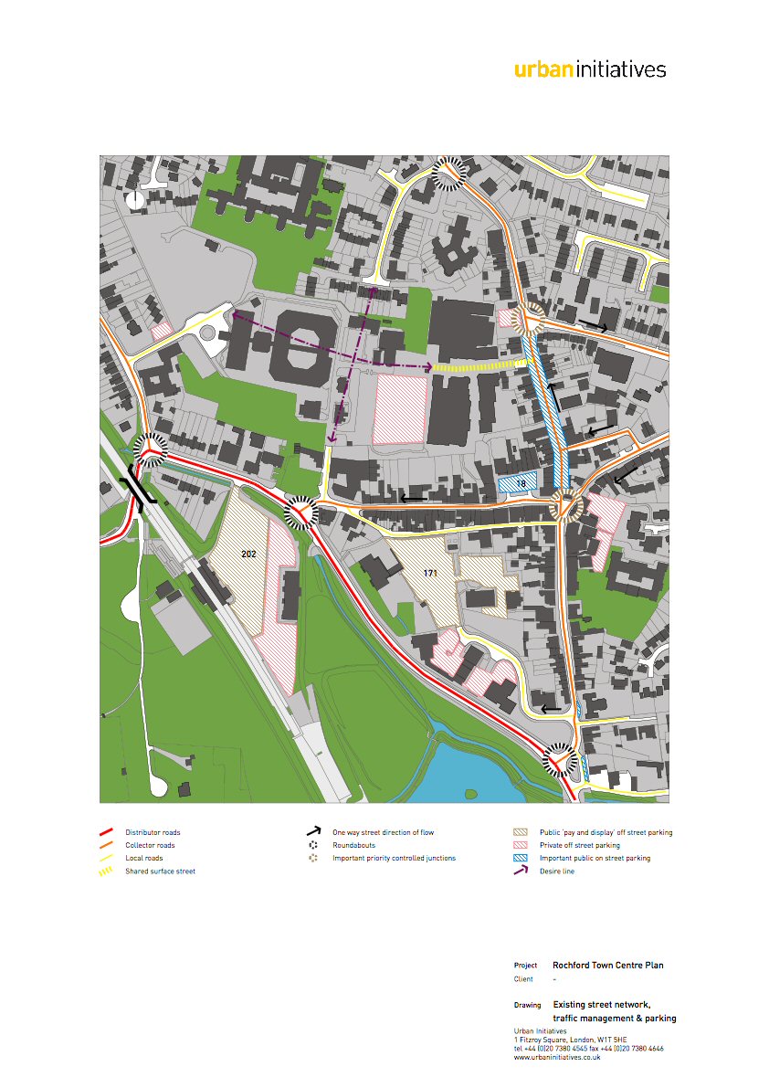
2.22 Southend Road and Bradley Way/West Street form the main highway route running along the western border of the town centre. Strategically, this route connects with Southend-on-Sea in the south and Hockley to the north. Ashingdon Road links through to the north of Hockley. South Street, East Street and Dalys Road serve an important local collector function running along the eastern and northern boundaries of the town centre.
2.23 For the town centre itself, its evolution from a village to a town pre-dated the advent of the motorcar. As a result the width of the streets are scaled to the pedestrian. The widths, generally 4-5m wide, are insufficient to cater for two-way vehicular flow. However, Rochford's position with the wider region and location on an important highway, has necessitated a measure of vehicular access through it. As a result, a circuitous one-way network exists through the centre. West Street is the narrowest, and is only able to cater for one lane of traffic. South Street has two way flow, however North Street is one way (due to its narrowness at Horners Corner), thus vehicles moving from north to south are required to divert around Weir Pond Road, and East Street to access South Street.
(1) 2.24 Traffic flows collected for Dalys Road (March 2006) show that it carries approximately 5,000 - 6,000 vehicles per day. While no other data exists for Rochford, it is expected that volumes along Bradley Way are significantly higher with a greater proportion of Heavy Goods Vehicles. Observations have also concluded that vehicles generally speed through the centre along East and North Streets given the scale of the street.
2.25 In terms of traffic junctions, roundabouts manage vehicular access through and into Rochford along Bradley Way and along Dalys Road, most of which are small mountable versions, with numerous observed incidences of vehicles driving straight over the islands. The use of roundabouts is in response to Rochford's relatively suburban/rural setting, which has not necessitated the use of signalised traffic control systems.
(1) 2.26 Rochford's street pattern does not lend itself to permeable movement. As is evidenced by Rochford's focus of retail and small business activity on West Street and North Street, the provision of missing or improved links in the middle of the town centre has the potential to open up redevelopment opportunities and relieve pressure on the one-way system. These movement desire lines are shown in the analysis diagram Figure 4 - Street network plan, though it should be noted they are only indicative.
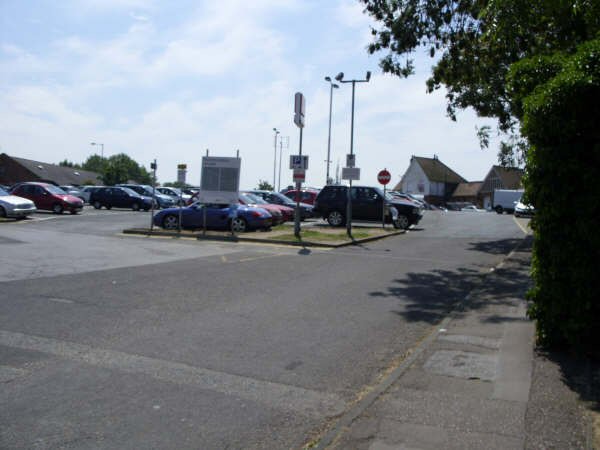
Parking
(1) 2.27 There are two main public off-street car parking locations in the town centre that occupy a large amount of land. The railway station car park contains 202 spaces and the Back Lane car park with 171 spaces. The station car park operates as a park and ride facility, whereas the Back Lane car park services journeys to Rochford itself. Very limited information is available on actual parking utilisation of these car parks as they are both pay and display parking facilities. A smaller pay and display car park on Old Ship Lane, between East Street and North Street, provides additional parking within the town centre.
(1) 2.28 Areas of private off street parking exist throughout Rochford, most notably, the parking adjacent to the railway station car park. This is a free parking area that is used by Rochford District Council staff and by staff and visitors to the Freight House.
(2) 2.29 The Market Square provides retail premises with eighteen parking spaces with a 30 minute time restriction. While no formal count was undertaken, this parking area was observed to have queues on average of three to five cars waiting on West Street to get a parking space, with an approximate wait time of between two - five minutes. A taxi rank with six spaces is also provided. In close proximity to the Market Square, North Street contains approximately fifteen on-street parking spaces, three disabled and two loading spaces. Loading time restrictions are also in force from 10.30am to 4.30pm, to ensure that parking spaces are used by retail patrons, and to ensure that loading activity does not block moving traffic lanes during peak times.
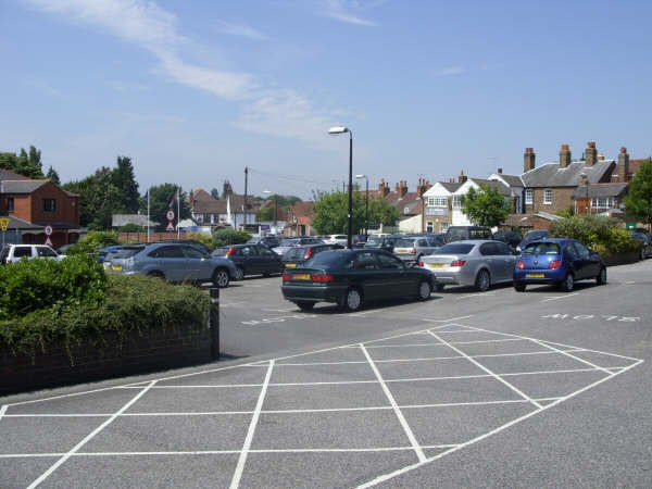
| Back Lane car park |
Figure 4: Street network plan
(1) PEDESTRIAN AND CYCLE NETWORK
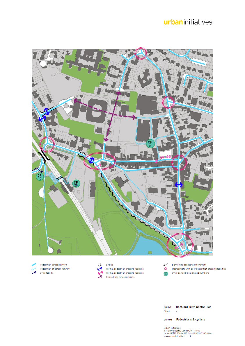
Pedestrian Movement
2.30 There is a definite concentration of pedestrian movement on South, North and West Streets associated with retail and small scale business uses. While the pedestrian experience on these streets is generally acceptable, the environment could be improved by slowing or removing traffic from these areas
(1) 2.31 Off-street pedestrian connections have been provided to the north of West Street in association with new development. Despite this, pedestrian permeability to the west is considered poor with limited connections to the station. The existing bulk and location of the Hospital is the main cause of this condition.
2.32 There are a number of junctions in the centre that act as barriers to pedestrian movement, resulting from traffic management solutions that have prioritised vehicle capacity and speeds. The roundabouts on Bradley Way are particularly problematic for pedestrians and hamper movement to the station. Of greatest concern are the junctions at either end of West Street given its importance as an access to the station and Market Square. This is a critical issue in making pedestrian journeys to the station more viable and attractive. Another opportunity exists in strengthening connections to the park to the south of Bradley Way.
Cycling Movement
(2) 2.33 Cycling through Rochford is of a generally acceptable standard, with the exception of the lack of provision of facilities at junctions and a tendency of traffic to speed through them by virtue of the method of traffic control. Resolving speed issues through the town centres narrow streets and slowing vehicles through improved junction treatments would have a marked impact on the cycling experience.
(1) 2.34 There is a cycle path running east along Hall Road that links up with the station. A reasonable spread and quantum of cycle parking exists in Rochford as illustrated in the figure on the facing page. At the station and to the rear of the Market Square by the Somerfield store the cycle parking is all sheltered. To the west of the station and on the Market Square itself, the cycle racks are for persons using the retail facilities and station and are therefore not covered.
Figure 5: Pedestrian and cycle network
PUBLIC TRANSPORT
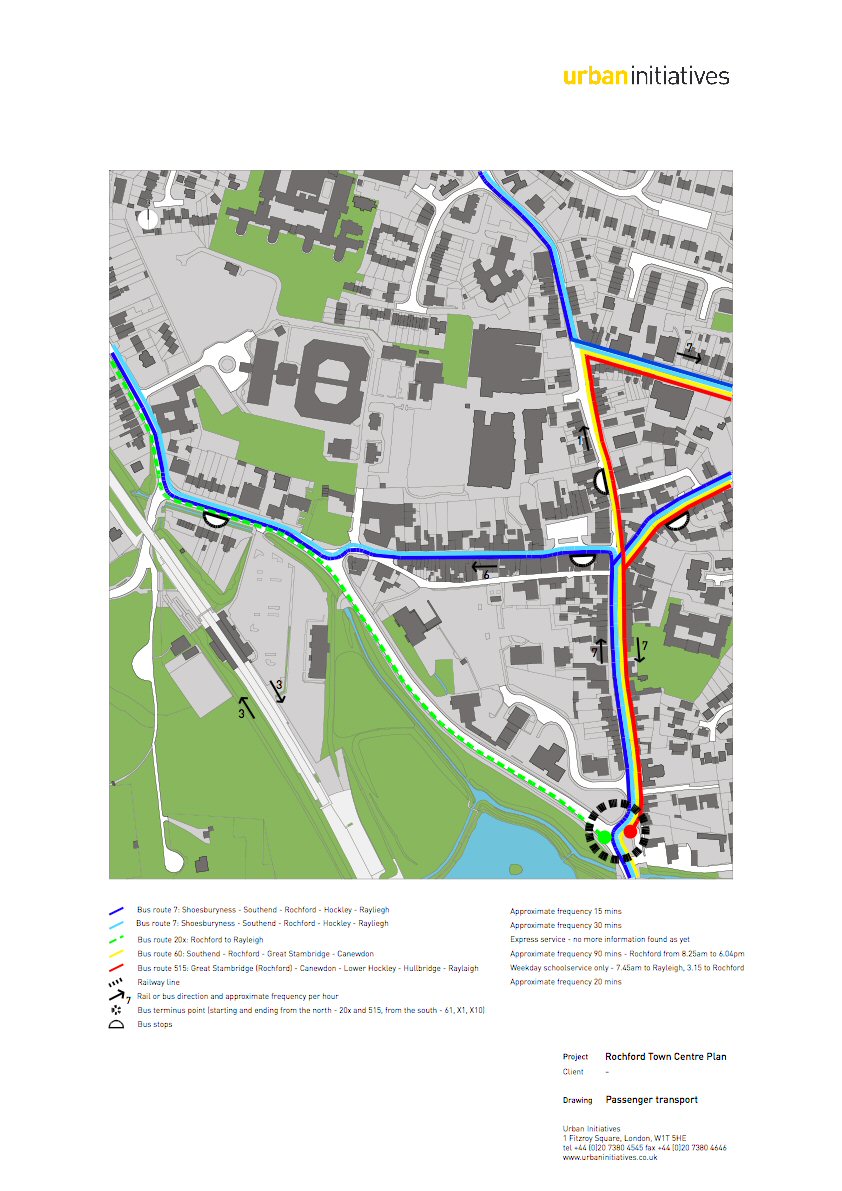
The Rail Network
(1) 2.35 Rochford is served by a train line, running from London Liverpool Street Station through to Southend Victoria in Essex and is located between Hockley and Prittlewell Stations. Trains run on a twenty minute headway in peak periods and a 30 minute headway in off-peak periods on Monday to Saturday. A 30 minute service operates on Sundays. Rochford is approximately 48 minutes travel time from London Liverpool Street station.
(1) 2.36 The Rochford rail station is a relatively well maintained station facility that is manned during the day. The platforms are both sheltered. A pedestrian overbridge provides access between platforms.
The Bus Network
(2) 2.37 There is a well established network of bus routes servicing Rochford. Some routes passing through Rochford serve Hockley, although the majority only go as far as Ashingdon. The two main routes are the 7 and the 8 services connecting Shoeburyness and Southend to Hockley and Rayleigh. Other routes through Rochford include the 20 express (no information is available at present for this route), and the 60 and 515. The 60 connects Southend to Canewdon.
2.38 Internally the 7 and 8 services run through Rochford from Southend to Ashingdon Road. Given the one way network in the town centre itself, northbound services use South Street and West Street. Southbound services use Dalys Road, Weir Pond Road, East Street and South Street onto Southend Road. The 60 service runs via South Street, North Street and Weir Pond Road, and the 515 service begins and ends its journey just to the south of Rochford Town Centre on Southend Road before heading east to Canewdon then Rayleigh.
(2) 2.39 Bus stops are scarce through the town centre and consist of signs only. No shelter is provided, due to the narrowness of the existing pavement layout, nor is there any service information available to users, with the exception of the southbound bus stop on East Street. Additionally, the one way network doesn't allow for the placement of stops as functioning pairs, nor gives the user a sense as to what direction the bus is going to head in. Given this, there is very little legibility of the bus network and stop locations. The stop locations themselves are also concentrated around the junction of West and North Street, with a notable gap in stops the further outside of the centre you go. Given the demographic of the area and the need for the bus system to be accessible to the elderly and mobility impaired, there is a definite need to explore the provision of basic shelters and information at key locations, and a more even distribution of stops at approximately 300m intervals. Careful bus stop placement can also be used as a mechanism for 'drawing' pedestrians past areas of interest or retail uses.
(1) 2.40 A particular issue in this regard exists with the level of interchangability of bus services with the rail station. At present, given circulation issues, buses only pass by the train station in a northbound direction. The nearest southbound bus stop is located on East Street to the east of the study area: a significant walk. This means that people from Canewdon area are not able to catch a bus to Rochford for the purpose of interchanging with the rail station, without a significant walk
Taxis
2.41 Taxis serve as an important mode of public transport for Rochford. A taxi rank containing capacity for six spaces is located on West Street where it meets the Market Square. It was observed that this area was heavily used during the day. A taxi rank is also located adjacent at the railway station entrance.
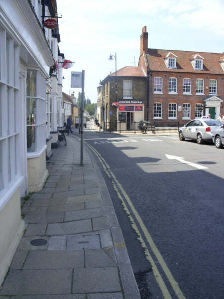
| View along West Street |
Figure 6: Public transport provision in Rochford
(2) SUMMARY OF ISSUES
(2) 2.42 The key issues that face Rochford are summarised in the table below:
Table 3: Summary of issues for consideration in Rochford Town Centre
| Theme | Summary of the main issues |
| Land Uses |
- A range of uses can be found (retail, commercial, and community) located mainly along West Street, however new development to the north (Somerfield and Roche Close) is disconnected from the centre: it is accessible only by North Street or via a pedestrian only route from the Market Square which runs past service areas and parking associated with properties in the Market Square. - Car parks occupy a large amount of space in the town centre - Buildings along Bradley Way are often purpose built making them inflexible in terms of changing their use - It is important to link the community activities to the north and west of the centre to the other uses in the town |
| Form and Structure |
- There are a large number of active frontages, however Back Lane is mainly lined by the backs of properties. - The Spar building to the east of the Market Square is not in keeping with the high quality of the rest of the Square and undermines the quality and character of the town centre - Uses along Bradley Way give little clue to the quality of the town centre - The quality of the link between the town centre and railway station could be improved |
| Conservation and Heritage |
- Rochford Town Centre is a Conservation Area with a picturesque historic core and a collection of buildings of high architectural quality, some are listed - Rochford has a fine grain of development with intimate spaces of human scale, good enclosure which should be respected in any new development - Any developments in the town centre will need to respond to this context having regard to the detailed analysis carried out in the Conservation Area Appraisal |
| Topography |
- The topography contributes to the character of the town and offers the possibility of an enhanced entrance to the town, making use of the views afforded from the railway station |
| Street Network / Management |
- The street widths are scaled to the pedestrian and are insufficient to cater for a two-way flow, which has resulted in a one-way network around the town centre - Roundabouts manage vehicle access through and into Rochford. Most of these are mountable roundabouts and there are many incidences of vehicles driving straight over them - There are two main car parks: at Back Lane and at the station both of which appear (without having undertaken a study) to have spare capacity. These are surface car parks and occupy a large amount of land in the town centre. - The parking area in the Market Square is pressurised with cars queuing for one of eighteen spaces (despite a time restriction of 30 minutes) - The problem of access to the Market Square and West Street due to queuing cars waiting for a parking space in Market Square. |
| Pedestrian and cycle network |
- Pedestrian movement is centred around the Market Square and its retail uses. - There are some problematic junctions for pedestrians at either end of West Street, as well as at the roundabouts on Bradley Way - Traffic moves quickly through the town centre, making some crossings difficult for pedestrians and cyclists |
| Public Transport |
- Rochford town centre is served by trains, buses and taxis - The bus service in particular has a number of problems having signs instead of stops with no shelter or information for users - There is not a good interchange between the bus service and the rail station. |
|
(5) Question: Do you agree that these are the main issues facing Rochford Town Centre? (3) Are there any other issues that you think should be considered? |