Battlesbridge Conservation Area Appraisal and Management Plan
7. Character Appraisal
7.1 The character of an area lies in the particular mix of architectural details and materials, and the relationship between buildings and spaces which forms a distinctive whole. The character of the conservation area at Battlesbridge derives primarily from its river associations, with many of the principal buildings associated with functions relating to the river. These buildings contribute to the industrial character of the settlement, and are given texture and interest by the use of traditional materials such as weatherboard and local handmade brick. Smaller scale traditional buildings including former shops and domestic cottages and gardens are also present, reflecting the development of the settlement as a self contained community. The river channel, embankments, marshes, drainage channels and mudflats are ever present features of Battlesbridge, and contribute to the open and spacious character with timeless river views. The bridge provides a focal point, its current Victorian manifestation concealing more ancient origins as a major river crossing point. As well as its important position at the head of the tidal river, the rural setting also contributed to the development of Battlesbridge. Agriculture remains an important element in the local economy, and the settlement retains a rural quality both in its architecture and in its green and spacious character.
Spatial Analysis
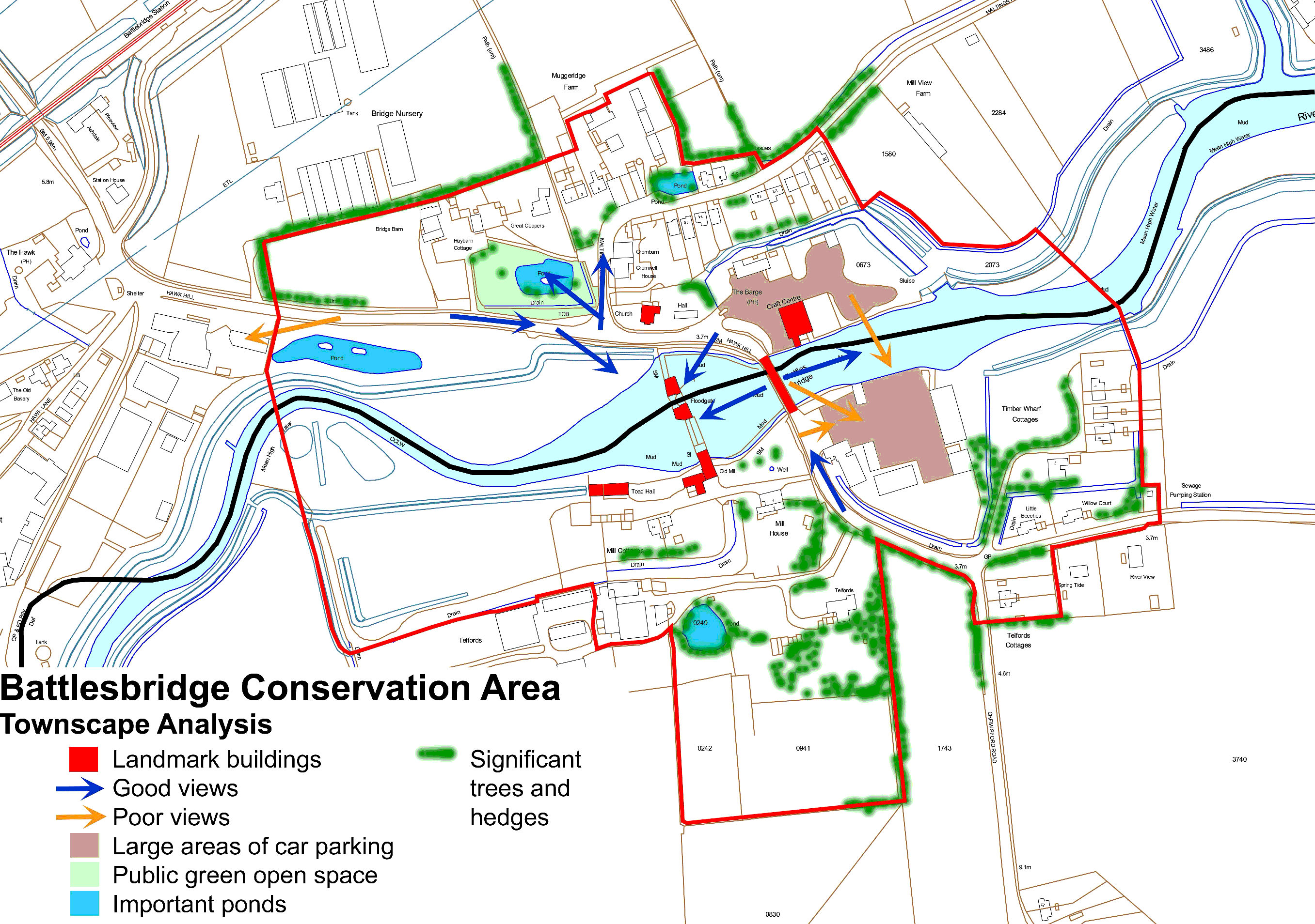
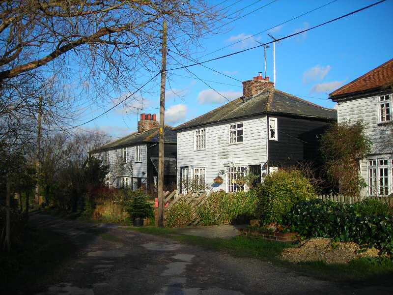
7.2 The conservation area has an irregular form, with the river channel dividing it from east to west. The principal roads that define the layout of the conservation area on the north side are Hawk Hill following the old route south from Chelmsford and Rettendon (Figure: 9), and the southern end of Maltings Road before it passes into more open arable countryside. Chelmsford Road heads south from the bridge, turning abruptly south again at Telfords Cottages where the conservation area terminates. A short length of Beeches Road is included, which heads east, following an old road through Beeches Common, before passing into more open countryside. An aerial photograph of the conservation area illustrates the relationship between the river, buildings, roads and spaces (Figure: 12). An analysis of the contribution of different elements in the spatial and townscape character of the conservation area, including views and green edges, is represented in the map below (Figure: 13).
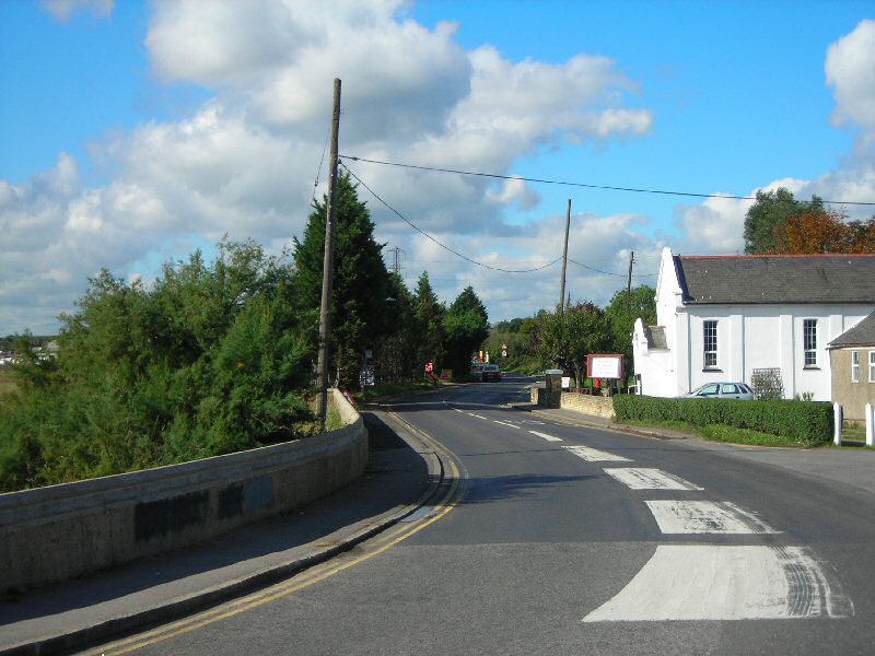
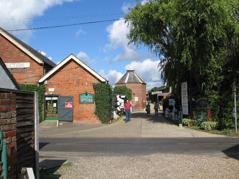
Figure 9: Hawk Hill looking west with the chapel on the right.
7.3 The conservation area generally has an open, spacious and informal character, with large areas of open space including green areas and hard surfacing encompassed within its boundary. The river channel and low-lying salt marshes are vital elements in the special character. On the north side of the river The Green is an important and attractive area of green open space (Figure: 10), and the open area around the old granary antiques centre also contributes to the spacious character. A former farm meadow is another, more enclosed green space to the north-west. On the south side of the river the former mill race is an important rectilinear feature enclosing green space and mud flats as well as the old tide mill buildings, whilst large gardens. A meadow and former orchard to the rear of Telfords are further elements in the spacious, green character. Battlesbridge Harbour is an open industrial area and former mill site contained within a drainage feature on the opposite shore from the granary antiques centre. East of this further drainage features enclose Timber Wharf Cottages as well as an undeveloped green space bordering the river channel.
Figure 10: The Green.
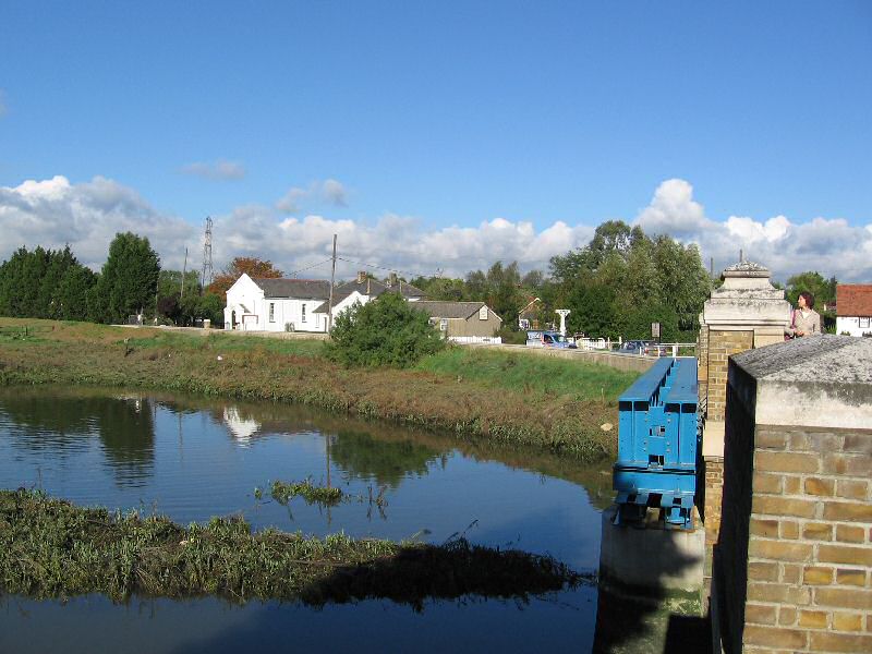
7.4 The sea walls, tidal mud flats and salt marsh plants introduce an estuarine atmosphere in this small enclave in an otherwise rural area. Drainage ditches and ponds add to the low lying riverside landscape, and the ditch to the rear of the Barge inn was formerly a navigable waterway. The openness of the area allows views out into the countryside, particularly to the east and west along the river, which are largely unspoilt. Views to the south across the river channel and salt marsh, towards the tidal mill and granary, are particularly good (Figure 11). However the overhead power lines, A130 and Hawk Lane industrial area are intrusive in the distance to the west and south west. The Battlesbridge Harbour area also appears untidy and detracts from the views directly south across the river. The sea wall has been raised in height on the north side as part of a major scheme of flood defence works. Although the new coping is robustly detailed and appropriate for its maritime context, the height of the wall and the difficult access to the riverside divorces the antiques centre car park and Hawk Hill from its riverside setting.
Figure 11: View south from bridge with drying kiln and tide gates.
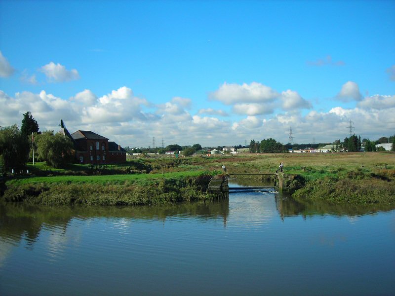
Figure 12: Aerial photograph of Battlesbridge.
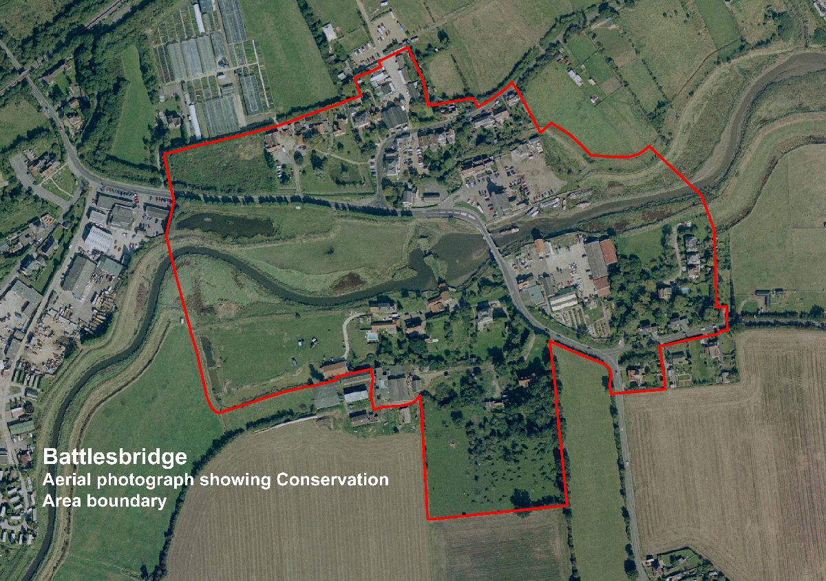
Figure 13: Townscape analysis of Battlesbridge Conservation Area.
Character Analysis
7.5 The built environment has a mixed character reflecting its location and historical development, with industrial buildings, agricultural buildings, small cottages and large houses all contributing to the street scene. The arrangement is loose and informal, with buildings often grouped according to their use or former use, principally industrial, agricultural or domestic. Although few of the non-domestic buildings have retained their original use, the area continues to have a mixed use character, including the antiques centre and associated buildings, public house, hotel, residential, commercial and office buildings. This mix of uses adds significantly to the vitality of the area. One of the most important aspects is the continued riverside activity, with moored barges and boats travelling up the river. The current uses of buildings within the conservation area is represented in the map below (Figure 18).
7.6 The oldest surviving buildings date from the 16th century, and there are a significant number of 19th century buildings reflecting the success of industrial enterprises at that time. The phased development of the settlement is shown in the map below (Figure 19).
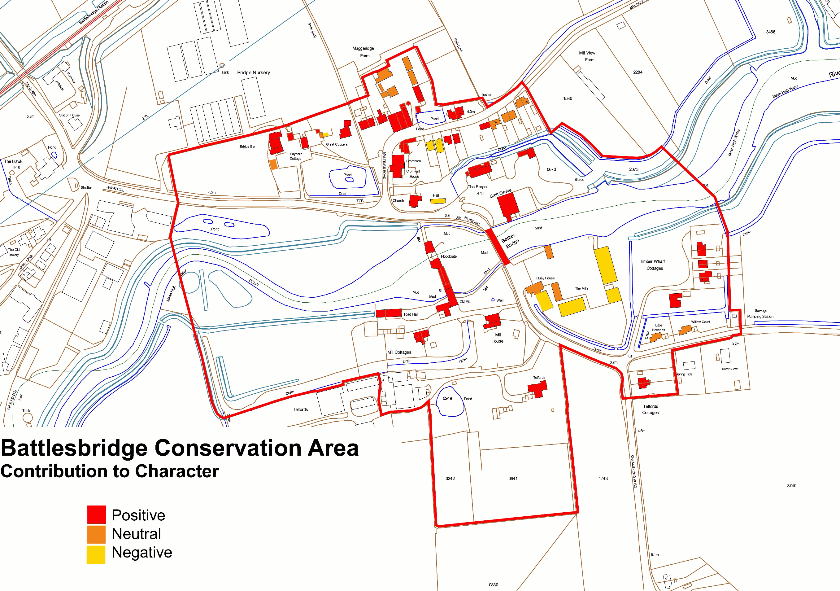
7.7 The north and south sides of the river have their own individual characteristics, although both are inherently linked by their strong associations with the river. For the purposes of analysis each area is separately covered below. An evaluation of the contribution of individual buildings to the special character of the conservation area is shown in (Figure 20).
Materials and Details
7.8 A varied palette of local traditional building materials contributes to the distinctiveness of the conservation area. The oldest buildings in the conservation area are typically timber framed, and may be weatherboarded, smooth rendered and painted, or with plaster infill panels. Some later brick built buildings are also smooth rendered and painted, usually in white or cream. Weatherboard is prevalent, and is generally painted white for buildings of domestic appearance (sometimes black to the side and rear elevations), and black for agricultural and ancillary buildings. White painted weatherboard is also traditionally used on some mill buildings (Figure: 14). Red brick, usually laid in Flemish bond, is also a commonly used walling material, as is yellow stock brick used from around the 1830s (Figure. 15). However the practice of cement repointing does not enhance old brickwork and is usually unnecessary. Brick chimney stacks are a common feature in the conservation area, and often have corbelled courses.
Figure 14: Weatherboarded lucam on the old tide mill.
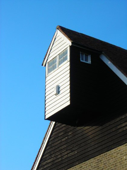
Figure 15: Natural colour variation in 19th century yellow stock bricks on the old tide mill.
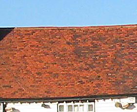
7.9 Roofs are generally clad in handmade plain clay tiles for steeply pitched roofs (over 45o) that give a natural colour variation (Figure: 16). Natural blue/grey slates or orange clay pantiles are used for lower pitched roofs (generally 30o-40o). Pantiles are more commonly used on ancillary and non-domestic buildings.
Figure 16: Natural colour variation in handmade clay roof tiles on The Barge Inn.
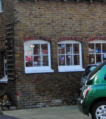
7.10 Traditional window and door treatments tend to be simple and understated. Timber joinery with a painted finish (often white) is typical, and traditional windows are generally symmetrical sashes or casements sometimes subdivided into small panes. Windows may be vertically or horizontally proportioned (Figure: 17). In brick buildings recessed windows typically have cambered brick window arches. Some unsympathetic replacement plastic windows intrude on the character of the conservation area. Painted timber boarded doors are traditional particularly on non-domestic buildings, and painted timber panelled doors are also seen in the conservation area.
Figure 17: Horizontally proportioned windows with cambered brick arches and painted timber joinery adjacent to the old tide mill.
7.11 Traditional boundary treatments tend to be low and unobtrusive, retaining the open character of the conservation area. Picket fences and hedges are appropriate for domestic properties in this rural context, and low brick walls either of local red brick or yellow stock brick with soldier capping are also seen. Less appropriate boundary treatments include high closeboarded fencing and tall, dense conifer hedges.
Figure 18: Uses of buildings in the conservation area.
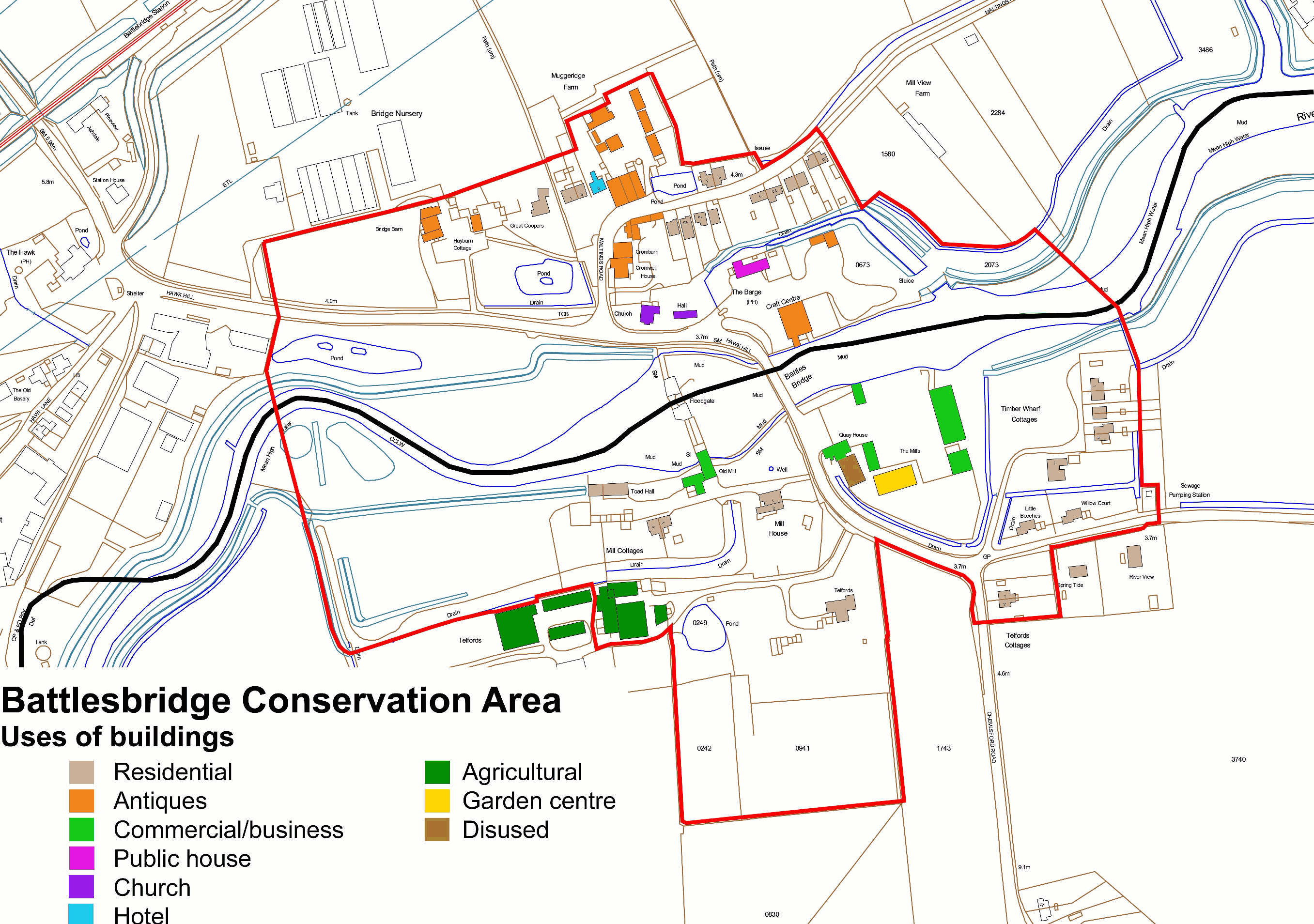
Figure 19: Phased development of buildings in the conservation area.
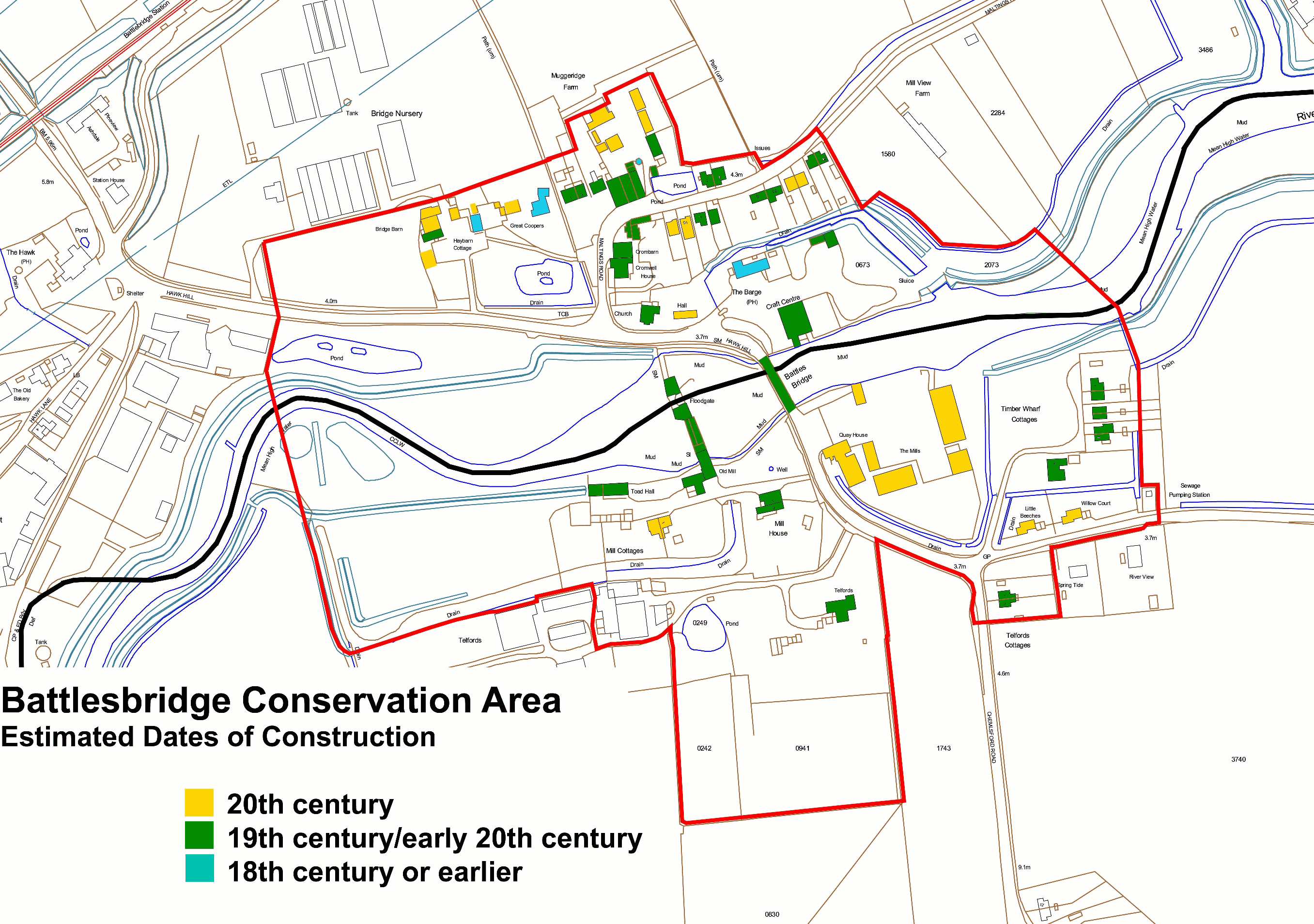
Figure 20: Contribution of individual buildings to the special character of the conservation area.
Area 1: North of the River Crouch (Chelmsford Borough)
7.12 The former granary buildings, bridge and river form the heart of the area, with the antique centre granary as a strong landmark from the surrounding area. The mix of riverside, agricultural and simple residential buildings gives the area a mixed built form which reflects its historic functions. The informal layout of the buildings and modest scale of the cottages to the fringe of the settlement, combined with the presence of many trees adds to the distinctive rural character of the area. For descriptive purposes this area is divided into three sub areas, The Riverside, Hawk Hill and Maltings Road.
The Riverside
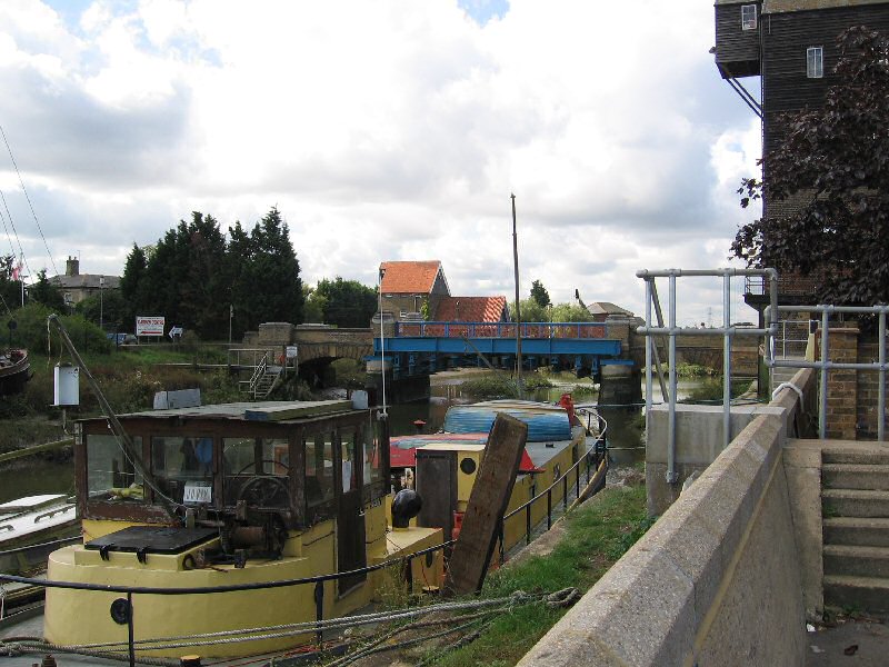
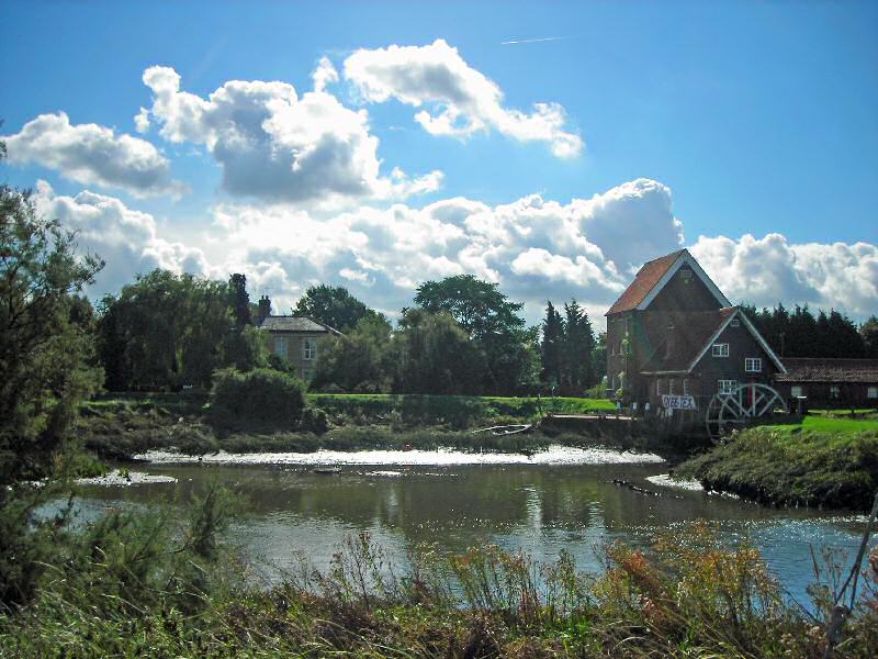
7.13 The Grade II listed bridge is a focal point and a fine piece of Victorian engineering in its own right. From the bridge there are good views along the river and across to the mill house, tidal mill and granary with drying kiln to the south-west, which form an impressive group (Figures 21 and 22). The road bridge is a Grade II listed structure and was built in 1872 by William Webster of London at a cost of £3,500. It has a cast iron central arch with stock brick side arches and brick parapets and end pillars. Although the construction of the A130 removed some of the traffic from the bridge, it continues to carry significant volumes of traffic which can be intrusive at times. The road bridge narrows to single file, which can cause waiting traffic to build up on either side at busy times.
Figure 21: View south from the bridge to the old tide mill, granary and drying kiln.
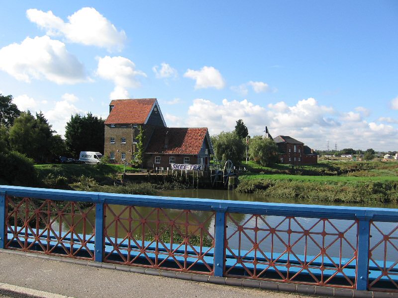
Figure 22: View north from the bridge, a less industrialsied scene compared with that shown in Figure 7.
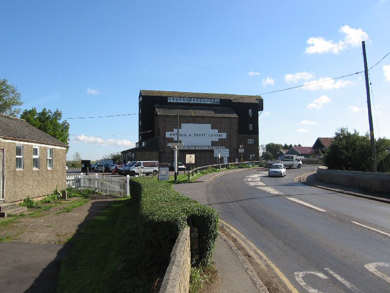
The antique centre granary is the dominant built feature and serves as a reminder of the settlement's strong association with riverside and agricultural activity. It stands high as an important local landmark and gives a sense of approach from the north and west, although from the south it appears suddenly on the approach along the curve in Chelmsford Road. It is illuminated at night and is clearly visible by passers on the new A130. The car park has been resurfaced in tarmac, with standard white lines used to mark the parking bays. This surface looks very harsh, undermines the rural character of the area and provides a poor setting for the buildings (Figure: 23).
Figure 23: The Barge Inn viewed across the car park of the Antiques Centre.
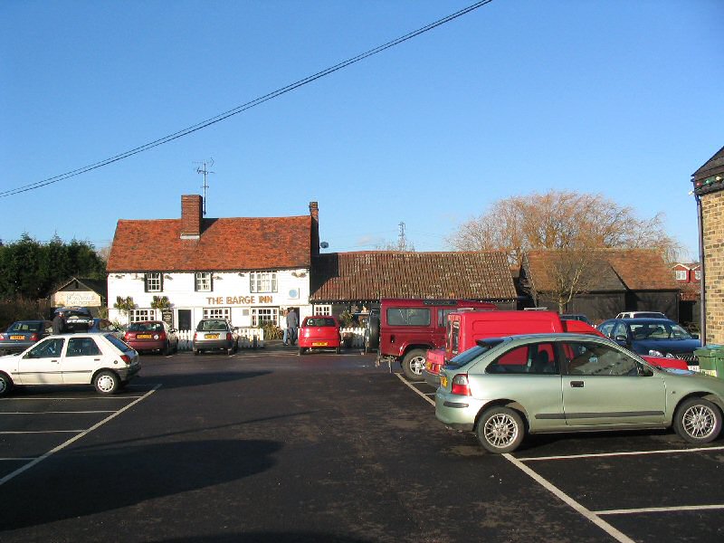
To the north of the granary the Barge Inn is a fine traditional Grade II listed pub (Figure: 23 above). It is a two storey timber framed building clad in weatherboard, originating from the seventeenth/eighteenth century. At the eastern end are single storey black weatherboard outbuildings. Further traditional outbuildings are located further east, which add to the informal, rural character of the area.
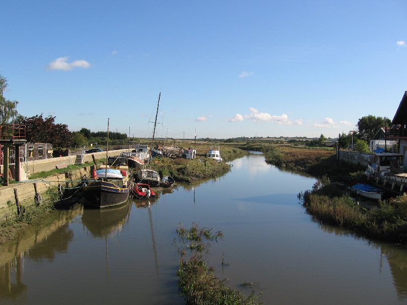
The drainage channel to the rear of the Barge Inn was historically a navigable inlet, but at present appears untidy and is bounded by visually intrusive panelled fences (Figure: 24). The barges moored at the riverside add significantly to the maritime character (Figure: 25) of the area and reinforce the historic use of the navigation.
Figure 24: Drainage channel to rear of Barge Inn.
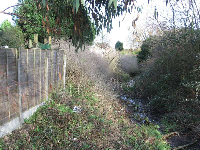
Figure 25: Barges on riverside.
Hawk Hill/Main Road
7.13 Hawk Hill is the main route through the settlement. Since the A130 and subsequently the new A130 were built, traffic flow has considerably reduced. However the traffic still remains an intrusive feature, particularly at peak times. The line of conifers along the southern side of the road is an oppressive and alien feature, which is prominent on the approach from the west and from the river crossing. Replacement with a native hedge would be a significant improvement and would still help to screen the industrial area to the west.
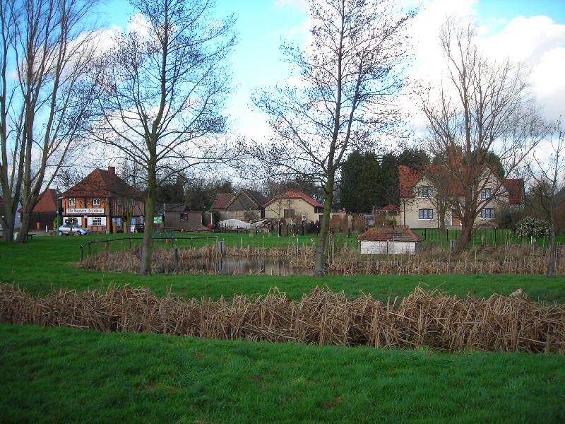
The main approach from the west gives good views to the antique centre granary (Figure: 26) and along the river, into the open countryside. The pond to the side of The Green provides an open setting to the buildings grouped to the north and east.
Figure 26: Antique Centre granary. The church hall is on the left.
The buildings around the pond are informally grouped. To the west, Bridge Barn is a traditional group of outbuildings used as part of the antique centre. The buildings are all modest in scale, with shallow plan depths and mostly weather boarded walls and steep plain tiled roofs. The open green and groups of trees add to the rural character of the area and provide a soft setting to the buildings (Figure: 27). Some of the advertising and storage paraphernalia associated with the antiques centre areas appears cluttered. Great Coopers (Figure: 28) is a fine Grade II listed seventeenth century timber framed house, which was relocated following the construction of Stansted Airport. It sits in spacious open grounds with soft planting and overlooks the pond and The Green.
Figure 27: The Green, with Grade II listed Hay Barn Antiques Centre right.
Figure 28: Great Coopers.
The chapel at the corner of Hawk Hill and Maltings Road is a strong feature on the approach to the bridge. Its simple form and slate roof are typical of mid nineteenth century chapels. Its windows have been replaced with inappropriate, lifeless, manufactured plastic windows. The hall to the east is a valuable local facility. Its orientation contributes to the informality of the building groups layout, but it is a run down temporary building made of poor materials. (Figures 26 and 29).
Figure 29: The church hall to the right of the white chapel.
Maltings Road
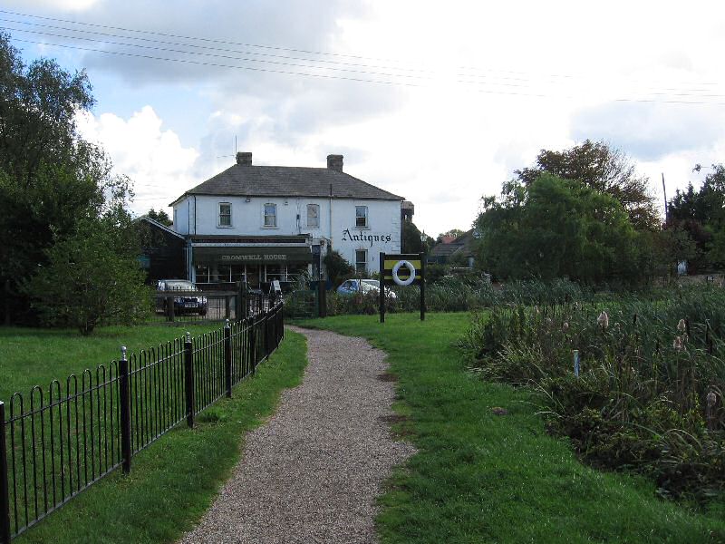
7.14 Maltings Road appears to have developed from a route along the northern edge of the common in the nineteenth century to Goose's Farm and a maltings (Figure: 30). The pond and The Green provide an open setting to the west. Cromwell House encloses the eastern vista (Figure: 31); it is a large mid nineteenth century building with a hipped slate roof and a good traditional shopfront. The surrounding trees provide a soft, natural setting. The finials to the former bridge, which was built in 1856 then demolished by a steam tractor, are located to the south.
Figure 30: Maltings Road.
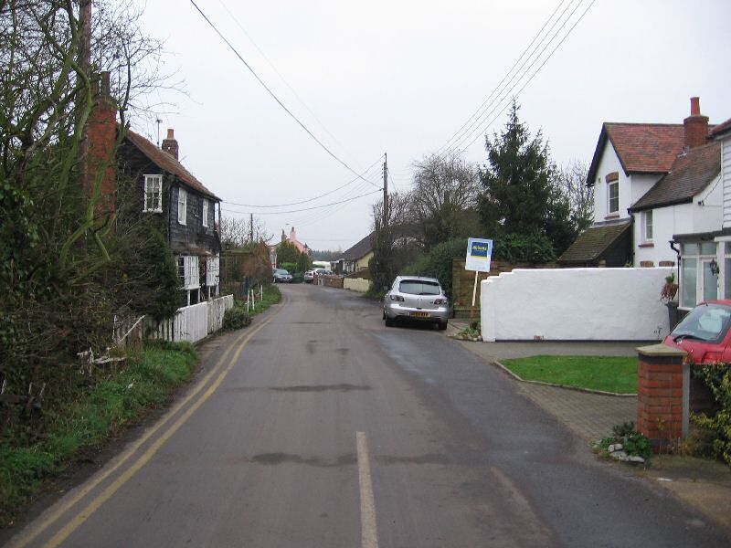
Figure 31: Cromwell House.
The outbuildings to Cromwell House and the front group of Muggeridge Farm provide a visual pinch point in the road. Numbers 1 and 3 are set well back from the road and follow the informal building line established by the buildings fronting the pond. Number 1 is a large rendered dwelling with a slate roof; it has a substantial garden with good tree cover. Number 3 is relatively unaltered and has full height projecting bays and a formal red brick elevation.
The buildings at Muggeridge Farm comprise many elements. Those of the most historic interest are located on the southern part of the site. The three gables to the nineteenth century brick barn enclose the corner of Maltings Road (Figure: 32), with the other buildings to the rear forming two courtyards. The rare Grade II listed eighteenth century octagonal dovecot is glimpsed from Maltings Road (Figure: 33).
Figure 32: Muggeridge Farm barn.
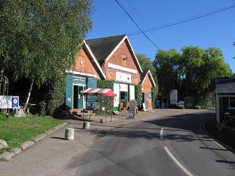
Figure 33: Muggeridge Farm dovecote.
Further east Maltings Lane has a more rural character, with buildings of modest scale and increasingly soft edges to the road (Figure: 34). The pond and groups of trees provides an attractive break in the built form. Dwellings are generally a low two storeys, slightly set back from the road edge.
Figure 34: Maltings Road.
Beyond the farm buildings, Numbers 7 and 9 (Figure: 35) are modest early nineteenth century cottages with a steep plain tile roof, black weather boarded walls and small paned painted timber windows. The pond, open garden, trees and white painted picket fence add to the building's rural setting. To the east the road edge is defined by hedges enclosing agricultural land beyond.
Figure 35: Nos 7-9 Maltings Road.
On the southern side of Maltings Lane numbers 8 and 10 are a pair of 1970s dwellings which establish a building line with the dwellings to the east. They present gables on to the street, which appear wide spanned and cramped within the street scene. The materials appear overly harsh and manufactured. Number 14 is a traditional nineteenth century cottage, with a hipped slate roof, white painted weather boarded walls and small paned vertically proportioned painted timber sash windows.
Number 16 is a modest detached Edwardian cottage with rendered walls and a plain tile roof. The large open garden of number 18 provides a break in the built form and adds to the informal rural character of the area. This mid nineteenth century building was formerly a terrace of four, subsequently converted into two. Number 18 remains picturesque, but the other half of the pair, number 22, has been significantly altered (Figure: 36).
Figure 36: Nos 18-22 Maltings Road.
Numbers 24 and 26 are bungalows with a very deep plan and dominant low pitched roof, which appear out of scale with the traditional cottages either side. The soft front boundary treatments help to reduce their impact. Beyond, Numbers 28 and 30 are modest cottages with a slate roof, which steps forward where the road gently curves. The large dormer windows and flat roof porches detract from their simple form. To the east good views are available south across the river to Timber Wharf Cottages.
Area 2: South of the River Crouch (Rochford District)
7.15 The old tide mill and associated buildings with their riverside setting are key elements in the character of the south side of the river, reflecting the industrial past of the settlement. In addition to the historic mill buildings, other wharfside buildings, larger mill owners' houses and smaller residential properties contribute to the mixed built environment. Trees make a strong contribution to the special character of the area to the south and east, enhancing its rural quality. For descriptive purposes the area is divided into Riverside, Chelmsford Road and Timber Wharf Cottages.
Riverside
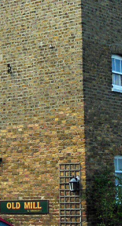
7.16 The old tide mill is what remains of the 1830s tide mill, and an important and rare survival in Essex (Figure: 37). It is Grade II listed, and the main building is of three storeys with a loft and a weatherboarded lucam, built of yellow stock brick with a clay tile roof. A single storey red brick and weatherboard range with a pantiled roof extends to the river bank and dam wall. The mill has been converted for business use, and suffers from over-prominent advertising on the riverside that detracts both from the building itself and from the wider setting and views across the river channel. An attractive stock and red brick outbuilding with pantile roof is included in the listing for its group value. A lean-to red brick and pantile extension has been added in recent years, along with a large covered seating area along the river edge, representing a significant modern intervention to the west of the building. The adjoining dam wall and tide gates are listed along with the mill. These features are historically important and make a valuable aesthetic contribution to the conservation area. They are currently in a very poor state of repair, and are included on the County Council's Historic Buildings at Risk Register.
Figure 37: The old tide mill with the granary and drying kiln beyond.
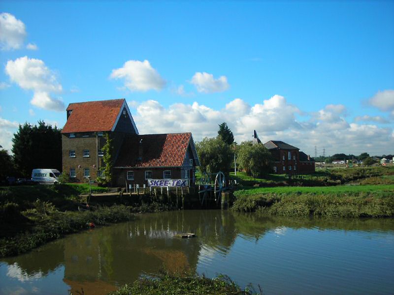
To the west of the tide mill the former granary and drying kiln are also Grade II listed. They were constructed in the early 19th century and were associated with the tide mill (Figure: 37). Now converted to a house (and known as Toad Hall), these buildings are constructed of soft red brick with a central main block that has a hipped slate roof and a single storey range extending west with a clay tiled roof. Like the mill, this building with its pyramidal slate-tiled kiln is a rare and important survival. To the south, the building is spoilt by an unsympathetic conservatory with brown framing, but viewed across the river along with the mill it contributes to an attractive and bucolic scene.
Figure 38: Toad Hall viewed from the south.
Mill Cottages are a pair of simple stock brick cottages built between 1897 and 1922 (Figure: 38). They complement the industrial mill buildings, and are well presented as a pair. The picket fence front boundary treatment is appropriate to the rural character of the area.
Figure 39: Mill Cottages.
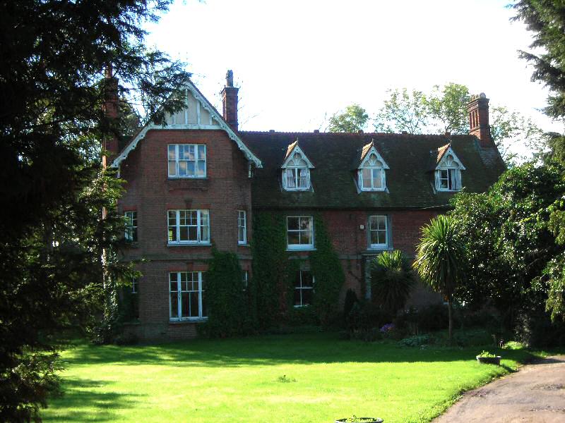
Mill House is an important element in the group of mill buildings south of the river (Figures 40, 41). Along with the other elements in the group it is accessed along a private road off Chelmsford Road. It was built in 1857 by William Meeson, and is a handsome building in extensive grounds now converted into two dwellings. Constructed of yellow stock brick with gault brick detailing including quoins, window surrounds and eaves course, its elegant appearance is spoilt by replacement UPVC windows. Mill House is visible from across the river and from the bridge, and with its wooded setting it contributes to the picturesque scene from these vantage points. Across the access road from Mill House an open green bank with trees and a brick well contribute to attractive views from across the river and enhance the green and rural character of the area.
Figure 40: Mill House.
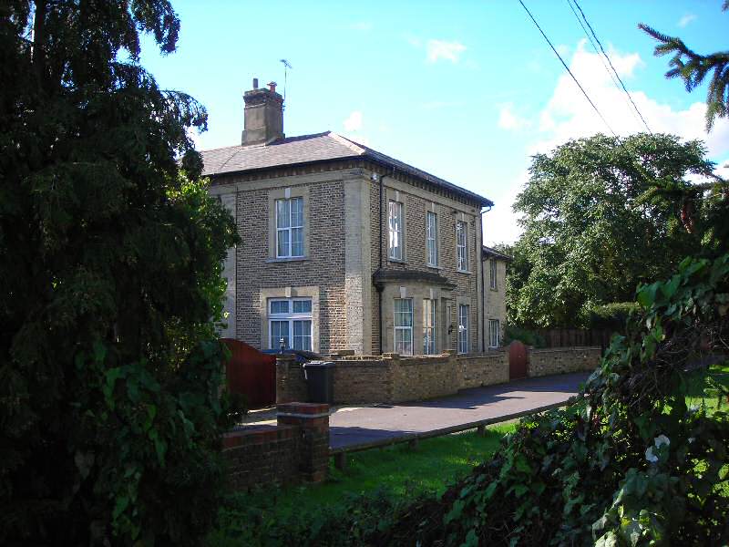
Figure 41: Mill House viewed from Hawk Hill with the tide mill.
Chelmsford Road
7.17 Telfords is an imposing Victorian villa, a former mill owner's house, constructed of red brick with decorative bargeboards and gabled dormers (Figure: 42). Although the present house is of 1890s appearance, there has been a house and farm in this location for centuries previously. It is set in wooded grounds with a meadow to the rear, and a footpath passes along the hedged field boundary at the eastern edge. Telfords Farm is accessed along a private track continuing past the main house. The modern farm buildings of Telfords Farm and others associated with the mill to the rear of Toad Hall are sufficiently set back to be only occasionally visible from across the river, and they are not intrusive. However any further developments towards the river may harm important views as well the setting of the listed buildings.
Figure 42: Telfords.
Battlesbridge Harbour is an industrial complex on the site of the 1930s mill that was demolished within the last 30 years, and which itself replaced an earlier mill destroyed by fire (Figure: 43). Some former mill and quayside buildings remain here. Quay House (now Perfect Vision) at the entrance to the site is an 1890s building that stood at the entrance to Meeson's mill site (Figure: 8). It is much altered with dominant flat roofed dormers and now displaying an assortment of advertising that intrudes on the character of the area (Figure: 44). To the south there is a redundant single storey red brick range which is in poor condition, and appears neglected and untidy from the Chelmsford Road (Figure: 45). The site also includes a distinctive long single storey weatherboarded and slate roofed building (Tack Shop) built around 1900 (Figures: 43 and 44). These two buildings have the potential to make a more positive contribution to the character of the area, particularly in views from the opposite shore, with improvements to their appearance and enhanced landscaping of their setting. An old pump building also survives, but has been significantly altered with a dominant deep-eaved roof which is over prominent in views from the north shore and on the approach along Hawk Hill (Figure: 46).
Figure 43: Battlesbridge, c.1909, showing the mill complex that previously occupied Battlesbridge Harbour. The long white building to the left remains, and the mill to the right of this burnt down in 1932.
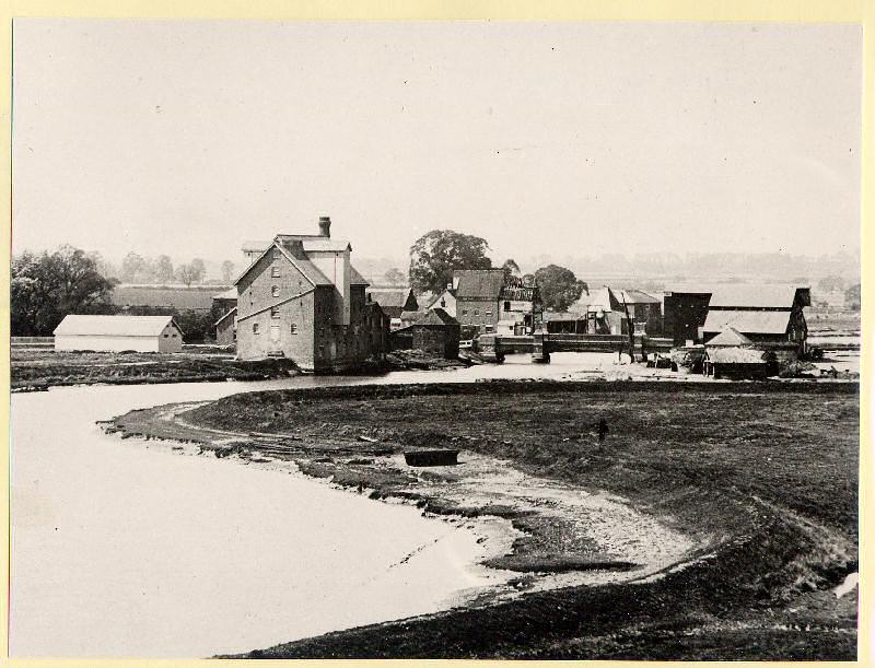
Figure 44: Quay House (right) and the Tack Shop viewed from the north end of the bridge.
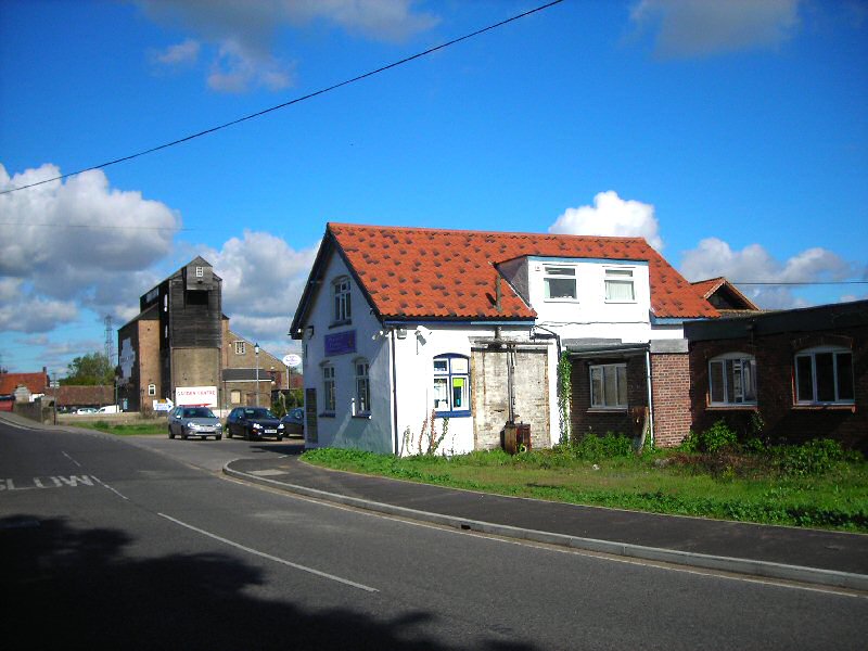
Figure 45: Quay House from Chelmsford Road with redundant south range to the right. The granary antique centre is beyond to the north.
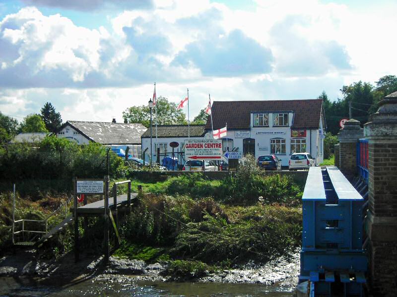
As well as these historic industrial buildings, the Harbour area includes modern industrial sheds, shipping containers and large open areas of car parking. Whilst an industrial character is appropriate for this former mill and wharf site, the appearance is generally poor, and creates poor views from the bridge and from Chelmsford Road. The high wire boundary fence along the road edge with open views into the site detracts from the attractive appearance of the conservation area, and cars parked outside the entrance also undermine the character of the area. Adjacent to Battlesbridge Harbour is Battlesbridge Mills Garden Centre, which again has a poor boundary fence along Chelmsford Road (concrete posts and chainlink wire) which displays an excessive amount of advertising (Figure: 47).
Figure 46: Entrance to Battlesbridge Harbour from Chelmsford Road, with former mill pump building on left.
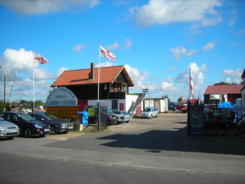
Figure 47: Battlesbridge Mills Garden Centre viewed from Chelmsford Road.

Where Chelmsford Road turns sharply south a neat pair of white rendered cottages, Telfords Cottages, mark the edge of the conservation area (Figure: 48). These late Victorian or early 20th century cottages have good decorative stucco detailing and round headed recessed doorways that create shadow lines, but they have replacement UPVC windows that detract from their appearance. The close-boarded fence with concrete posts to the left would be better replaced with a boundary treatment more in keeping with the character of the area, such as a hedging.
Figure 48: Telford Cottages.
Little Beeches and Willow Court are late 20th century detached houses constructed of modern materials on Beeches Road. They are set back from the road in well planted garden plots. These plots retain the boundaries of a former pair of semi-detached cottages that appear on the tithe map of 1838, bordered by drainage ditches. Whilst these houses are out of scale with more traditional domestic properties they do not intrude on the character of the conservation area, and their large garden plots contribute to the green and rural quality of the area.
Timber Wharf Cottages
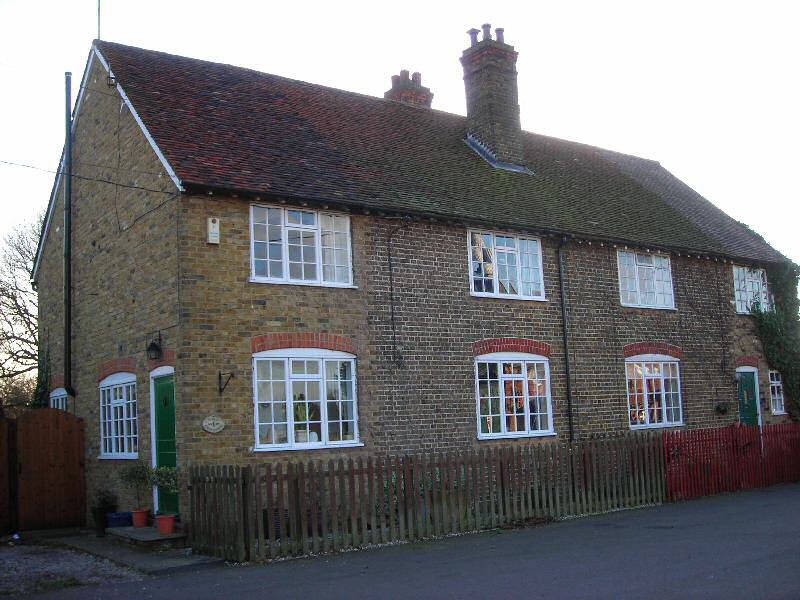
7.18 Behind Little Beeches an unmade tree-lined private track leads to Timber Wharf Cottages (Figs. 49, 50). These cottages form an attractive grouping, and although they have suffered some loss of original features and other alterations (including modest extensions and replacement of windows) the extent of these alterations has not as yet undermined the overall coherence of the group or their traditional character. The group consists of an elegant detached house set back on a green with willow trees, and three pairs of more modest semi-detached cottages. They are all weatherboarded painted in a traditional scheme of white to the front and black to the side. The detached property has been reroofed with machine made interlocking tiles, whilst two of the pairs have slate hipped roofs and one pair has a clay tile hipped roof. Their informal front boundaries and garden planting contributes to the rural quality of the area. These cottages were mainly constructed between 1830 and 1838, with one pair of cottages added subsequently to the same design. They were associated with the Marsh Timber Yard and quay, located on the riverside to the west of the cottages within a drainage enclosure. Although not visible from the public highway on the south side of the river, they can be seen from the north from Maltings Road across the river channel. Opposite the cottages is an undeveloped green plot with trees and hedges which to some extent helps to screen the industrial site. The informal and unmade access track is an important contributory element in the informality and special character of this grouping.
Figure 49: No. 7 Timber Wharf Cottages.
Figure 50: Timber Wharf Cottages.
Problems and Pressures
Unsympathetic alterations
7.19 Many unlisted buildings make an important contribution to the special character of the conservation area. Some of these have suffered from unsympathetic and uncontrolled alterations carried out as permitted development which undermine the traditional and distinctive character of the conservation area. These alterations include replacement of traditional timber windows and doors with UPVC, boundary treatments that are unsympathetic to the rural context of the conservation area, reroofing of properties with modern materials that are not traditional, and installation of flat roof dormers. The negative impact of these alterations can be seen at numbers 18-22 Maltings Road. Whilst number 22 has retained many original features, number 18 has undergone significant alterations including plastic cladding as opposed to timber weatherboard, reroofing in concrete tiles in place of slate, loss of a brick chimney, and a closeboarded boundary fence in place of a traditional timber picket fence (Figure: 35). Quay House is a traditional pitched roof brick-built building where large flat roofed dormers are alien features (Figure 44). Boundary fences around Battlesbridge Harbour and the garden centre have already been mentioned as unsympathetic to the character of the conservation area. Incremental alterations of this kind can seriously erode the special character and distinctiveness of conservation areas over time.
Advertising
7.20 Whilst it is acknowledged that the purpose of advertising is to attract attention and is essential to commercial success and vitality, advertisements of inappropriate design, materials or scale can be detrimental to the appearance of the building on which they are displayed as well as to the character of the wider area. Conservation areas are particularly sensitive to the style of advertising used on businesses. The effect of inappropriate advertising can be seen on the old tide mill where attractive views across the river channel are undermined by prominent advertising. A proliferation of advertising material can also lead to a feeling of clutter which detracts from the special character and appearance of conservation areas. At Battlesbridge this can be seen in the area of Battlesbridge Harbour and the neighbouring garden centre, where buildings and boundary fences display a large number of advertisements.