Battlesbridge Conservation Area Appraisal and Management Plan
6.1 Origins and Development
6.1 In the Mesolithic period the area of what is now the upper Crouch estuary was dry land that was available for occupation, hunting and foraging. By the Neolithic period the estuary was approaching its present form, with high water roughly where the low water mark is today, and further marine transgression occurred in the late Roman period.
6.2 The ancient origins of the place name of Battlesbridge are unclear. Writing in the 1860s Philip Benton suggested that the place name might be associated with the nearby Battle of Assandune between the Saxon king Edmund Ironside and the Dane Canute, or perhaps with some other battle (Benton 1888, 647). However the name Battlesbridge is more probably linked to the family of Reginald Battaille, and is first mentioned in 1351 as Batailesbregge (Reaney 1935). This suggests that the river was bridged by this date. There was certainly a bridge by 1571 when it was described in Quarter Sessions as 'ruinous and in great decay' (Newman 1970). This was a timber structure, and seems to have frequently required repairs. A new bridge was constructed in 1769, also of timber. For a brief spell the route over the bridge was a turnpike, granted to a Trust which operated between 1794 and 1820 (Booker 1974, 103). The old timber bridge was replaced by an iron structure in 1856, but this was destroyed when it was struck by a large steam traction engine, and the present structure was erected in 1872.
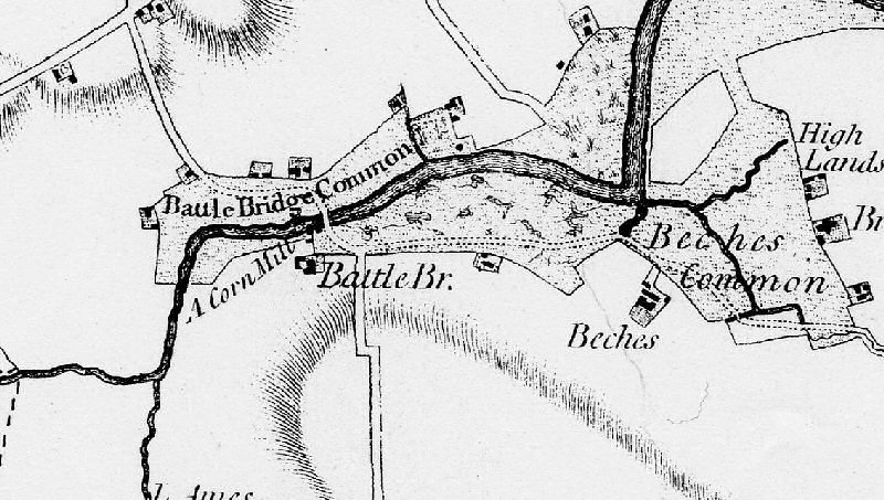
6.3 Medieval activity in the Battlesbridge area is represented by a number of moated sites. A possible moated site has been identified at Battlesbridge Mill on the west side of the road (EHER 7607). The Chapman and André map of Essex of 1777 is a good indicator of the settlement pattern at the end of the medieval period (Figure 3). It shows a number of scattered farmsteads fringing Battle Bridge Common to the north of the river, and unenclosed marshland to the south. Beeches Farm was a moated site to the south east of Battlesbridge (EHCR 7517). A corn mill had been established by this time, although it is not known when the first mill was built. The Chapman and André map also shows that the river was not yet embanked along this stretch. According to Benton, the grass marshes near the bridge were inned around 1812, creating marshes suitable for sheep grazing. Tidal defences were established by the time of the First Edition OS map of 1876.
Figure 3: Chapman and André map, 1777.
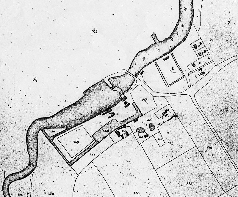
6.4 It is likely that Battlesbridge was already established as a small port for the transport of produce along the Crouch by the end of the medieval period, and it continued to expand as a port and an industrial centre in the post medieval period. The mill shown on the Chapman and André map was a timber structure erected around 1771, on four floors with two wheels, three flour mills and four pairs of stones (Benham 1976). Archaeological survey prior to work on the new flood defences identified the remains of timber posts in the vicinity that were probably part of the flood gates associated with the operation of this mill (EHER 45131). By 1815 the mill was in the ownership of John Deeley, passing to his son on his death in 1828. A granary and drying kiln had been added to the mill complex by 1830, which still survive. By 1836 the mill had been rebuilt, and the two wheels were replaced by one large breast wheel 18 feet in diameter and 10 feet wide (Benham 1976). The tithe maps of 1838 shows significant development of the settlement since 1777, with cottages, shops and gardens to the north as well as kilns, and a new channel cut behind what is now the Barge pub (Figure 4). To the south a new mill race had been cut and the new mill buildings are shown on the south bank, as well as further cottages to the east (Figure 5).
Figure 4: Tithe map of Rettendon parish (north of the river), 1838.

Figure 5: Tithe map of Rawreth parish (south of the river), 1838.
6.5 By the late 19th century Battlesbridge was a working community of mills, farms, and coal yards as well as lime kilns and maltings, with wharfage provided on both sides of the river. Barges from London took away flour and stacks (hay for London's enormous population of horses). Coal from the north was unloaded at the mill quays into the coalyards. There was also a brisk trade in malt, lime and chalk. The river itself was a source of smelt, flat fish, whiting, whitebait and occasionally sturgeon and salmon. The settlement's role as a centre for industrial activity and goods transport was strenghtened by the opening of The Crouch Valley railway line in 1889 for both goods traffic and passengers, with a station at Battlesbridge. Mill operations developed under the ownership of William Meeson, who built a new mill house in 1857. A new steam mill was built on the north bank of the river below the bridge in 1896, and supplemented by a further mill erected on the south shore soon after. The majority of the old tide mill complex was demolished in 1902-3, but a section remains attached to a length of the old dam wall, along with the drying kiln and granary.
Figure 6: 1st Edition OS map, 1876.
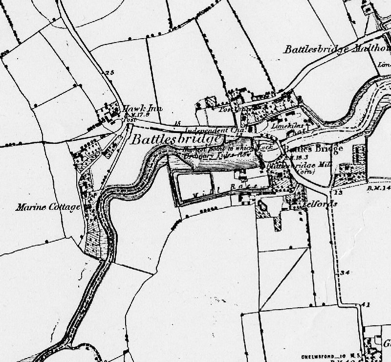
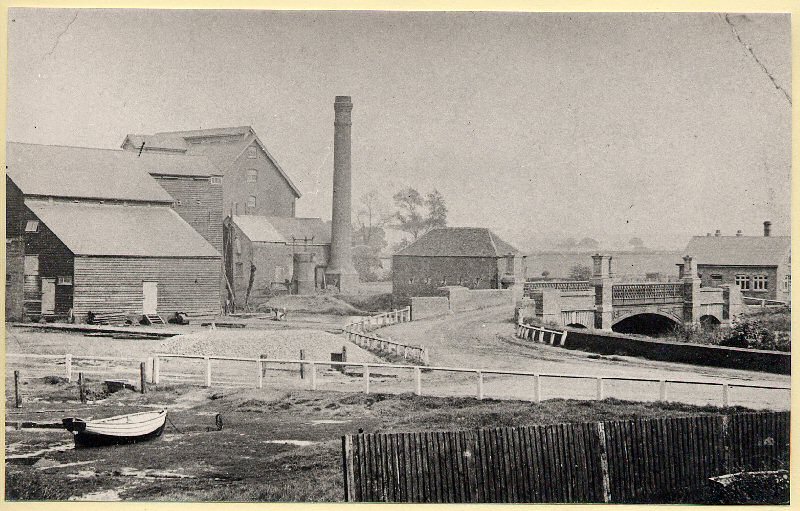
Figure 7: Barges at Battlesbridge with lime kilns in the background, pre-1909 (ERO I/Mb 287/1/12).
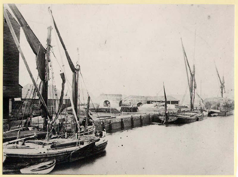
Figure 8: Battlesbridge, pre-1909. The mill to the left burnt down in 1932. The single storey building beyond the bridge still stands, much altered, as Quay House (ERO I/Mb 287/1/19).
6.6 By the First World War traditional riverside industries and goods transport at Battlesbridge were in decline. In 1932 a major fire destroyed one of the mills. Since the 1960s Battlesbridge has been reinvented as a popular centre for antiques and crafts, and many properties on the north side of the river are used for the sale of antiques and collectables. The Barge Inn is another popular attraction. On the south side of the river a former mill site at Battlesbridge Harbour is now a business and retail area with a garden centre. Outside the conservation area there is an industrial area and caravan site to the west, and further plant nurseries on the fringes of the settlement.