Canewdon Church Conservation Area Appraisal and Management Plan
5. Origins and Development
Location and landscape setting
5.1 Canewdon lies in the north of Rochford District, south of the Crouch estuary. The town of Rochford is approximately four miles to the south west.
5.2 The main village settlement is surrounded by Green Belt, and is bounded to the west and north by Coastal Protection Belt which follows the western boundary of the Canewdon Church conservation area.
5.3 The geology of the wider area comprises brickearth deposits overlying patches of head and gravel. The village occupies a low hill of London Clay about 30m above sea level, south of the marshes. The hill is one of the highest on the Essex coastline, and the church commands a dominant position on the western edge of the village with wide views across the Crouch estuary. The hilltop location is reflected in the settlement name which has the Saxon meaning 'hill of Cana's people' (Reaney 1935).
5.4 The coastal landscape of the Crouch Estuary has changed considerably over time. Until the post-medieval period the tidal marshes bordering the Crouch estuary came much closer to the village. Between the edge of the London Clay on which the village now sits and the river was a broad sweep of coastal marsh which would have been bisected by numerous small creeks and tidal channels. Much of it may have been submerged with each high tide. Piecemeal embankment and drainage of the marshes took place throughout the medieval and early post-medieval period until final enclosure in 1774. The coastal marshes are under renewed threat from rising sea-levels (Medlycott 2003).
5.5 The surrounding landscape is predominantly composed of arable fields. Boundary loss has resulted in large prairie fields in places, but there is a rectilinear pattern of fields along the axis of the main east-west roads through the village representing a more historic field structure, perhaps pre-medieval in date.
5.6 The village stands on a quiet country road leading from Hullbridge eastwards to the reclaimed land between the Crouch and the Roach estuaries, terminating at Wallasea Island. The church and churchyard close the High Street at its western end, and can also be reached via a lane that climbs the hill off Lark Hill Road. This lane also provides access to The Vicarage and Canewdon Hall Farm.
(1) Historical development2
5.7 Despite a lack of formal archaeological excavations a range of sites and deposits are known at Canewdon reflecting multi-period occupation from at least the Neolithic (4,000-2,000 BC). The elevated position of the site made it an attractive choice for early settlers, and its proximity to the coast was valuable for sea trading and salt production. Prehistoric and Roman settlement in the area comprised farmsteads and cemeteries on the higher ground, and salterns and other coastal sites fringing the edges of the marshes. Gravel extraction in the early 18th century to the north of the church revealed a cremation cemetery of unknown date. In the first half of the 20th century gravel extraction revealed an important range of prehistoric remains including a Neolithic axe hoard and Iron Age burials. One of the most significant finds from the area is the Bronze Age Canewdon paddle, now in the National Maritime Museum, Greenwich, which demonstrates the close links with the coastal environment. The area to the north of the present settlement is characterised by a line of Iron Age or Roman Red Hills (salt production sites) marking the edge of the coastal marsh at that date.
5.8 The earliest documentary reference to the place-name of Canewdon is in the Domesday Book of 1086, although the place name indicates earlier Saxon origins (Reaney,1935). The area between Canewdon and Ashingdon is widely believed to have been the site of the important battle of Assandune between the Saxons under Edmund Ironside and the armies of the Danish King Canute. Canewdon is identified in local folklore as the site of King Canute's camp, and Canewdon church is a possible candidate for the site of the Minster built by Canute in 1020 to commemorate the war-dead. However the location of both the battle site and the Minster are matters of academic dispute.
5.9 The Domesday Book records Canewdon at the very end of the Saxon period in 1066, at which time there were a total of 28 households. The lands belonged to Swein of Essex, the principal land-holder of the Rochford area, who would have had a hall there. Although the location of the hall is not proven, Canewdon Hall which lay to the north of the church (outside the present conservation area and now occupied by Canewdon Hall Close) is the most logical site. The parish church of St Nicholas is known to have been in existence in 1100, when the advowson was acquired by Prittlewell Priory, and it is probable that a church existed on the site prior to the Norman Conquest. The location of the late Saxon settlement is unproven, but comparison with other sites would suggest that a number of households would have been clustered close to the church and hall. The remainder would have been scattered throughout the parish in individual farms and cottages.
5.10 By the beginning of the medieval period the area was divided into five manorial holdings, Canewdon Hall, Pudsey Hall, Apton Hall, Scotts Hall and Lambourne Hall.The principal manor of Canewdon comprised 26 households in 1086, whilst the four smaller manors had 19 households between them. The medieval settlement is thought to have consisted of a mix of village settlement close to the church and Canewdon Hall, individual manorial holdings, and scattered farms and cottages.
5.11 Canewdon Hall which, together with the church, formed the focus for early settlement in Canewdon, was at one time a fortified or moated mansion. Morant (1768) recorded that Canewdon Hall "hath been a strong fortified place, in the manner of a castle, doubly trenched and fenced after the oldest fashion. The remains of the moates are still visible". The Hall was rebuilt around 1807. Parts of the medieval moated complex were still visible in the mid-19th century when local historian Philip Benton reported on the site (Benton 1867), and moated earthworks are indicated on the First Edition OS map of 1873. The buildings were demolished in 1966 and the moat levelled. Canewdon Hall Close was built on the site.
5.12 The church, dedicated to St Nicholas, is unusually large for a rural parish church. The majority of the church as it stands today, including the nave, chancel and north aisle, is of 14th and 15th century date, and we have no information on whether the great size of this building reflects an earlier church on the site. On the north side of the chancel was the de Chanceaux Chantry or chapel, now demolished. The tower is early 15th century and is exceptionally tall and substantial. Its height meant that it served as a navigation landmark for shipping within the Crouch during the reign of Queen Elizabeth I. In local folklore, Canewdon and the surrounding area has strong associations with witchcraft, and local tradition has it that whilst the church tower stands there will always be six witches in the village. From the top of the church tower there are extensive views of the surrounding countryside.
5.13 A vicarage was ordained in Canewdon in about 1231 by Roger Niger, bishop of London. The vicarage house and grounds were located to the south of the church. A purpose built vicarage of red brick construction, was built by George Walker in 1758 on the presumed site of the medieval vicarage. A map of 1788 shows that The Vicarage once had a formal arrangement of south-facing gardens leading down the hill, with outbuildings arranged around a courtyard (Fig. 3). The Vicarage is now in private ownership. It is Grade II listed.
Fig. 3 Map of Vicarage Lands, 1788 (ERO D/DU 743)
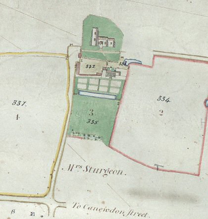
Fig. 4 Chapman and André map, 1777
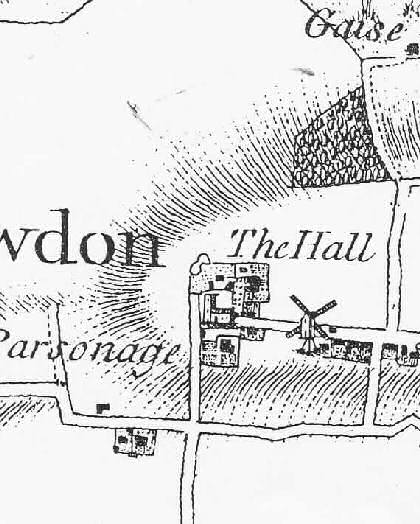
5.14. A degree of nucleation took place in the later medieval and post-medieval period with the development of the village along the High Street to the east of the church and hall, as well as more dispersed settlement around the four smaller manorial halls and scattered isolated farms and cottages. The extent and location of the later medieval village settlement can be assessed from the 1777 Essex map of Chapman and André, which shows the church/hall complex and a line of dwellings along the southern edge of the High Street (Fig. 4).
5.15 The village lock-up or cage, used by the parish constable for the temporary imprisonment of felons, is believed to have been constructed in 1775. It was originally located along with the stocks now housed within it close to the village pond . About 1913 the cage and stocks were moved to Anchor Lane, with a charge of one penny made to view the interior, and the building underwent large-scale restoration at the time. It was moved to its present position outside the east gate of the churchyard in 1938.
5.16. Recent excavations in the south-west corner of the churchyard to install a new septic tank uncovered human remains in a grave likely to be of 18th century date. This was a relatively wealthy individual, buried in a decorated coffin with good quality iron fittings. The excavations also revealed part of a brick wall with a window opening housing an iron grille that appeared to be 18th century in date, and was most probably the cellar of a now removed building. This may be the remains of Churchyard House, which is shown on the Tithe Award map of 1840 (Fig. 5), although it does not appear on the Chapman and André map of 1777. A building is marked in this location subdivided into two dwellings by the time of the First OS map of 1873, and had disappeared by the time of the 1974 edition (Hillman-Crouch 2006). A second small weatherboarded building existed to the west of the tower at about the same time, the purpose of which is not known.
Fig. 5 Tithe map, 1840

5.17 In the late 18th century a number of new buildings were erected which were to play a key role in community life. These included a school and schoolmaster's house, built in 1799 on the south side of the High Street using parishioners' money on Poors' Land. The schoolhouse was used until at least the 1850s, when a new school was erected further along the High Street, at which point the old building became the residence of the schoolmaster. The old school is now known as Vicarage Cottage and is a private residence.
5.18 By 1801 the population was 569, rising to 723 in 1841, and declining once more to 495 in 1901. The local economy was based on coastal industries, agriculture and the brick industry, but economic prosperity declined during the latter 19th century. Writing in 1867, Philip Benton recorded that the area already exhibited a degree of neglect, with some houses unfit for human habitation, and 'few recreations ... except those enjoyments afforded by the public houses'.
Fig. 6 Canewdon from the 1st edition OS map, 1873. Further development has occurred to the north of the High Street, but the west end towards the church is undeveloped
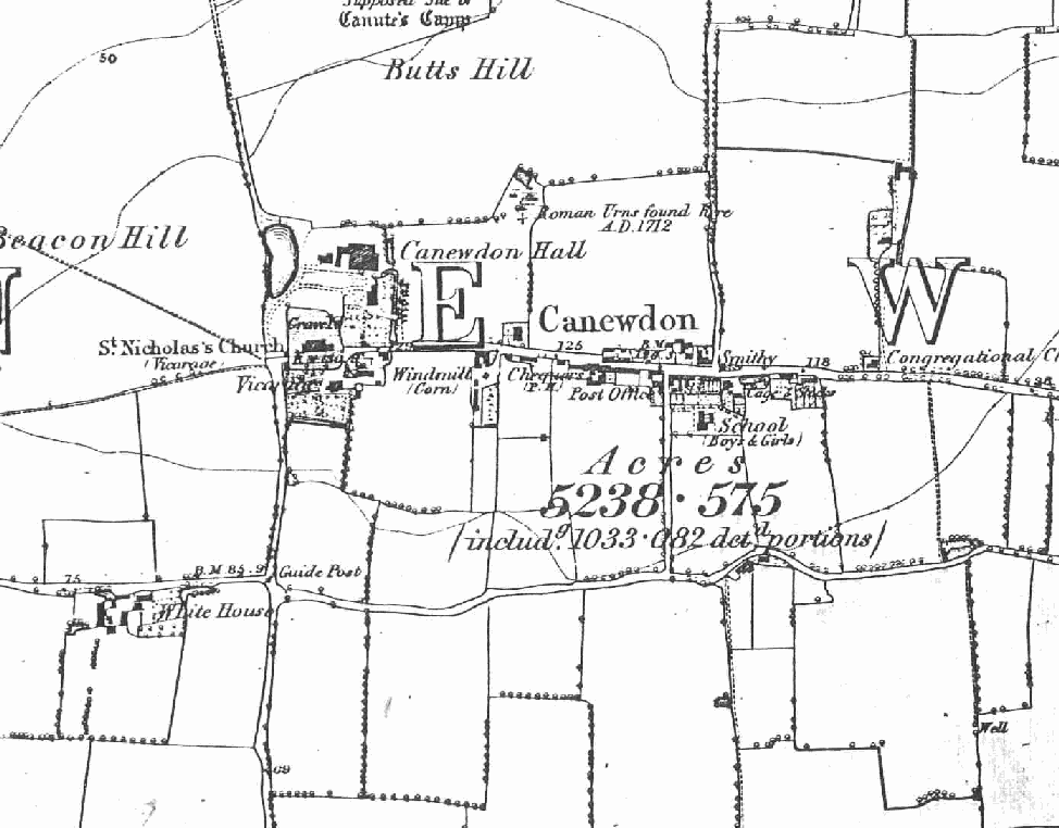
Fig. 7 Canewdon from the 2nd edition OS map, 1897. This map shows the continuing separation between the church/hall complex and the village settlement along the High Street
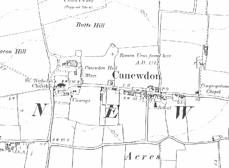
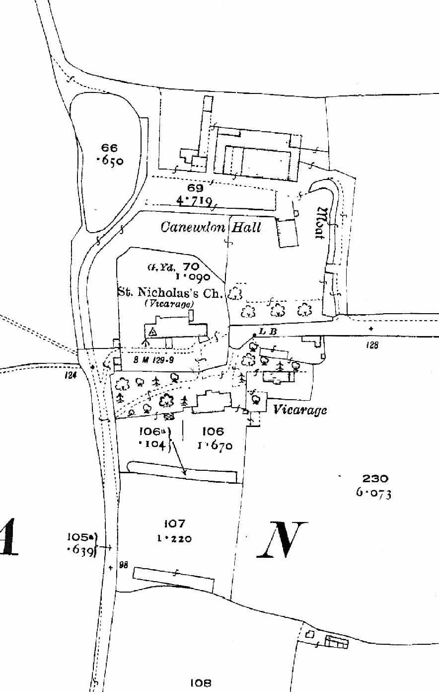
Fig. 8 Canewdon Hall, church and vicarage from the 3rd OS map, 1924. At this time remains of the moat from the earlier hall are still visible north east of the church. The map shows that trees made an important contribution to the grounds north of The Vicarage. A line of trees is also shown to the north of the High Street
5.19 Canewdon village was significantly extended by residential development in the latter 20th century, including the building of the model village to the south west in the 1960s. Today the village offers a wide range of local services including village stores, pubs and a school, and it is a close knit community. The 2001 census revealed the population of the parish to be1477 with 558 households. The area includes Wallasea Island, a popular centre for sailing and fishing, and the site of an ambitious project to create new wetland habitat by breaching the old sea walls.
2 For the history of Canewdon from an archaeological perspective, see Medlycott 2003, and for Canewdon and the wider historic environment of Rochford District see the Rochford District Historic Environment Characterisation Project report of 2005. General village history can be found in publications by Ken Smith.