Issues and Options Document
(259) 8 Delivering Infrastructure
Strategic Priority 3: The provision of infrastructure for transport, telecommunications, waste management, water supply, wastewater, flood risk and coastal change management, and the provision of minerals and energy (including heat)
(9) Introduction
8.1 Infrastructure is essential to support local communities and facilitate local economic growth. The equality of infrastructure in terms of services and facilities is challenging across the district given that we have such a large rural area to the east, which can mean that isolation becomes an issue. The west of the district, whilst still in need of infrastructure improvements, is markedly better connected than the more rural east. The rural areas of the district to the east of Rochford often have limited services and facilities including poor broadband access. This, coupled with poor public transport links, can make it difficult for those that do not have a car to access the services and facilities they need.
8.2 Any scheme – whether that is for the delivery of new homes or new jobs – will inevitably have some impact on local infrastructure, and it is the responsibility of the planning system to identify what is needed to support a particular development. However this extends beyond just the need to consider local infrastructure within our district, but also how we relate to infrastructure, such as roads, schools, open spaces and healthcare, within other areas of South Essex and what impact we may have on these services and facilities. It is an important issue for those who may be affected by schemes coming forward through the planning system; and is a concern that has been raised throughout early engagement with local communities in 2016. Our Infrastructure Delivery Topic Paper 2017 sets out our current position in relation to infrastructure requirements for planned growth up to 2025. This will be updated and further refined, through working closely with infrastructure and service providers, as we develop our plans for the future of our district to become an Infrastructure Delivery Plan (IDP).
(170) Highways Infrastructure
(14) Tell Us More SP3.1: How can we prioritise and deliver improvements to the strategic and local highway network over the next 20 years?
Where are we now?
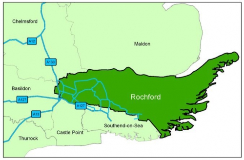
8.3 The western extent of the district in particular is well located in relation to three strategic roads, namely the A127, A130 and A13. The A127 and A13 provide access to London, a key employment generator and commuter hub, and the wider area via the M25, and the A130 provides access to north Essex and beyond (see Figure 10). There are four train stations serving Rayleigh, Hockley and Rochford, with a dedicated station for London Southend Airport on the London Liverpool Street to Southend Victoria line.
Figure 10: The main local and strategic roads serving our district
8.4 Although the district is well served by train stations, there is a high level of car ownership in the district with 63% of commuters travelling by car or van compared to 16% by train, as identified in the Highways Baseline Technical Note. This means that there is a high level of out-commuting to employment locations outside the district, most notably London. In total over 14,000 people commute to work elsewhere in the country. Essex County Council is the Highway Authority for the district and is responsible for the maintenance and improvement of the local and strategic highway network.
8.5 Car dependency and the impact of commuting on the local and strategic highway network is recognised within current policy, and through the balanced approach seeks to direct development towards appropriate locations around the highest tiers of settlements. Each of the allocated sites for new homes (set out in the Core Strategy and Allocations Plan) is required to deliver local improvements to the highway network; these have been and will continue to be secured through the planning application process. Other localised improvements are identified in the Area Actions Plans. However, due to the nature of planning, improvements are limited to those that are directly related to a development site, and are proportionate to the impact of the scheme alone. This is a requirement which is controlled by legislation.
8.6 Any scheme that is delivered can only mitigate its own impact; it cannot rectify any existing deficiencies. The NPPF (paragraph 32) is also clear that "development should only be prevented or refused on transport grounds where the residual cumulative impacts of development are severe." On-site highway improvements and enhancements to nearby junctions, for example, would be acceptable, whereas any major off-site improvements or financial contributions to deliver improvements elsewhere – depending on the scale of impact from a scheme – would not be acceptable. We are however working to deliver a Community Infrastructure Levy (CIL) charge on schemes in the future, which would mean that financial contributions could be sought from different types of development to potentially contribute to the network improvements beyond a development area.
8.7 It is recognised that there are issues associated with a high car dependency population and high levels of out-commuting in the district. We have worked with Essex County Council as the Highway Authority for the district to prepare a baseline position on the local highway network to illustrate on a district-wide basis where there are current issues. The Highways Baseline Technical Note sets out the existing condition of the network which will be used to inform future modelling of the network and identify potential mitigation options which will assist in taking forward the plan-making process.
8.8 However whilst the district benefits from access to the strategic highway network, our location in the south east of Essex is constrained by neighbouring boroughs and the Thames Estuary to the south, the north sea to the east and the River Crouch to the north, which offers somewhat limited opportunities for enhancing accessibility without substantial sums of investment. We recognise that there are issues with the function and capacity of the strategic highway network and junctions – particularly the A127 and key junctions such as Rayleigh Weir and the A127/A130 Fairglen Interchange.
8.9 We are, and will continue to, work closely with Essex County Council, and neighbouring authorities, to seek all opportunities for funding the necessary improvements. Essex County Council, for example, has successfully secured a commitment of £27m to deliver improvements to the A127/A130 Fairglen Interchange from the South East Local Enterprise Partnership (SELEP) through the Local Growth Fund supported by Essex County Council capital funding.
What are the identified issues?
8.10 There are a number of outlying villages and rural employment opportunities in the east of the district. There is a need to improve east to west connections to reduce this divide and ensure that rural employment opportunities remain visible and viable. This includes the area to the north east of Canewdon which is home to Baltic Wharf and Essex Marina, and the RSPB's Wild Coast Project at Wallasea Island. It also includes the area to the south of the River Roach in proximity to Great Wakering.
8.11 On both the local and strategic highway network there are recognised congestion and capacity issues. With the local routes there are issues of through traffic. Our adopted Core Strategy policy T2 identifies key areas of concern in relation to the east of Rayleigh and Rochford, and the west of Hockley, where commuters are likely to be drawn through the town centres to reach the employment destinations of Southend, Basildon and Chelmsford. This in turn could have a detrimental impact on the local environment and health.
8.12 Rayleigh town centre south towards the A127, for example, was designated an Air Quality Management Area (AQMA) in February 2015[33] due to annual mean levels of nitrogen dioxide(NO2) marginally exceeding the nationally prescribed level. This is considered in more detail in the 'Protecting and Enhancing our Environment' chapter. However, one of the measures to assist with reducing the annual mean levels of nitrogen dioxide (NO2) within the town centre – identified within the Air Quality Action Plan (AQAP) – includes consideration of a bypass for the town. Consultees recommended consideration be given to a bypass around the town, however the AQAP notes this would likely entail very high costs and long timescales. Also the scale of the problem in the town centre does not justify a bypass but the AQAP does recognise that this could be an option to mitigate highways impact of planned development in the future.
8.13 There is a lack of resilience on the local highway network, in particular incidents such as large volumes of traffic queuing at key junctions and stationary vehicles, or obstacles along main routes impacting on the capacity of the network and causing congestion. This has an impact on journey times and the ability of residents to not only reach their destinations in a timely manner, but in some cases to leave their villages or towns. Residents expressed concern, for example at the community engagement workshop in Hullbridge in 2016 about access for emergency vehicles but also exiting the village in general. Traffic management and parking are other issues which need to be considered, and are discussed in the 'Detailed Policy Considerations' chapter.
8.14 There is an issue of through-traffic across the district between Rochford, Hockley and Rayleigh in particular on the B1013. Traffic is also drawn through the district to go northwards towards Chelmsford and elsewhere in the north of the county to, for example, access Watery Lane which is not part of the strategic highway network.
8.15 Specific junctions and roads have been highlighted by local communities through the early community engagement programme, which took place in 2016, as areas of concern they would like to see addressed. These areas have also been broadly identified in the Highway Baseline Technical Note and include (but are not limited to) the following highways:
|
|
|
|
|
|
|
|
|
|
|
|
|
|
|
|
|
|
8.16 A number of the district's railway bridges have also been identified as 'pinch points' for both vehicles and pedestrians in the Highway Baseline Technical Note, for example the rail crossings at Hall Road in Rochford, Spa Road in Hockley and Rectory Road in Hawkwell.
8.17 The A127 is a key strategic highway serving South Essex providing an important east to west connection between Rochford District and Basildon, Castle Point and Southend Boroughs, which has known capacity and congestion issues. Essex County Council and Southend Borough Council's joint strategy A127 – Corridor for Growth – An Economic Plan 2014 is a Route Management Strategy for this strategic route. This strategy acknowledges the importance of this route to the South Essex economy and the maintenance and improvements necessary for this key artery to continue to support the local economy in the future. An options assessment report for the A127 is currently being developed. Improvements are taking place at Kent Elms junction in Southend Borough and upgrades have been completed at the Rayleigh Weir junction on the borders of Rochford District. There are also major improvements planned for the A127/A130 Fairglen Interchange to improve the function and capacity of the junction over the longer term, although there is a recognised need for a joined up approach across South Essex to support improvements to the A127. This is a particularly important element of the Duty to Co-operate, which is a legal requirement, as set out in the Duty to Co-operate Topic Paper 2017.
8.18 We need to continue to work with neighbouring local authorities and Essex County Council as the Highway Authority to promote strategic and more localised improvements to the highway network. Any improvements can be identified through the new Local Plan. Basildon Borough Council have, for example, identified the potential for a new link road from the A127 at Pound Lane to link to the A130 in Rochford District.
8.19 Surface access to London Southend Airport has also been identified as in need of improvement as set out in Core Strategy policy T2 (considered further in 'Delivering Homes and Jobs' chapter). Improving access on both the local and strategic highway network is vital to supporting economic growth and the continued prosperity of the district and wider South Essex area. There are a number of options that have been identified to improve the local and strategic highway network. However it is important to acknowledge that although improvements may need to be made there are limited funds available which could deliver improvements to the local highway network; particularly if significant improvements to the strategic network are also sought.
What are the realistic options?
8.20 There are four options that have been identified for the local highway network.
|
Option |
Justification |
|
Core Strategy Policy T1 sets the broad approach to ensuring localised improvements to the local highway network as schemes are proposed. It also identifies particular improvements to the east to west highway network, and the area serving Baltic Wharf for improvements to support rural employment opportunities. Core Strategy Policy T2 identifies specific roads and junctions for improvement which are supported – some of which have been secured (for example improved access to King Edmund School, Rochford and Rayleigh Weir junction). This aspect of the policy could be updated, depending on the outcome of future modelling work. |
|
It is recognised that there is an issue of through-traffic on the B1013 between the three town centres, which has a negative impact on the capacity of key junctions across the local highway network at peak times. Funding – for example through CIL – could be used to deliver improvements to the local highway network between the three towns. This could be informed by detailed future modelling of the highway network and the development of a Route Management Strategy. |
|
The route from Rawreth Lane in Rayleigh or Watery Lane in Hullbridge along Lower Road is a well used route which bypasses the three town centres, and provides an informal, alternative route into a number of towns and villages across the district. This could be considered through detailed future multi-modal modelling of the highway network as an option to alleviate issues particularly within Rayleigh town centre, as suggested within the Air Quality Action Plan. |
|
This would involve just relying on localised improvements as part of any new development coming forward through the planning application process. This may also mean that resources would be focussed solely on seeking improvements to the strategic highway network. However there are recognised issues with the local highway network which need to be resolved to increase capacity and reduce congestion where possible. This would be contrary to the NPPF and is not considered to be a suitable option. |
8.21 We will need to work with Essex County Council and Southend Borough Council, as the relevant Highway Authorities, to develop a transport model for South Essex, which covers the length of the A127. There are two options identified for the strategic highway network.
|
Option |
Justification |
|
Essex County Council is the highway authority for the district, and is responsible for the A127 west of the Progress Road junction. Improvements are taking place at the Rayleigh Weir junction to the south of Rayleigh. Funding has been secured for future improvements to the A127/A130 Fairglen Interchange junction to the south west of Rayleigh. This will require land adjacent to the junction to facilitate these improvements, which can be allocated through the new Local Plan. Other improvements may also be identified through the multi-modal modelling work for the district and South Essex. |
|
There are recognised issues with the strategic highway network that need to be addressed through cross-boundary working between the relevant highway authorities – in particular Essex County Council and Southend Borough Council. This is not considered to be an appropriate option to address this cross-boundary issue, which is also important for the Duty to Co-operate. |
(56) Sustainable Travel
(16) Tell Us More SP3.2: How can we improve sustainable travel choices across the district to deliver realistic and meaningful travel options for our communities over the next 20 years?
Where are we now?
8.22 Whilst there is a desire to encourage a modal shift towards alternative, more sustainable ways to travel, the economic and social importance of car usage in the district should not be underestimated. It is also recognised that people cannot be forced to not use their cars; however we must try to give local communities the option to use alternatives ways to travel where they can. Alongside seeking improvements to the local and strategic highway network to ensure there is adequate highway infrastructure to support the needs of the district in the future, sustainable ways to travel – such as passenger and public transport, walking and cycling – will continue to be promoted. These alternative ways to travel are realistic longer-term options for the district, which can have a positive impact on local congestion, emissions and air quality (specifically within the Rayleigh Air Quality Management Area). This in turn can have a positive impact on the health and well-being of local communities.
8.23 Passenger transport services are the responsibility of Essex County Council, which delivers a valuable service to support those most in need in our communities. This includes transportation for vulnerable children, older people, those with learning disabilities and physical and sensory impairments to facilities around the county, and bus services for pupils to and from school. Essex County Council also supports and funds some commercially unviable services which are considered to be important for local communities, where possible. We will need to continue to work with Essex County Council to ensure that passenger transport meets the needs of our communities over the next 20 years, with a particular need to support our ageing population.
8.24 Public transport is another valuable service for those who do not have access to a private vehicle, particularly within the more rural areas of the district, and is supported within our Core Strategy (policy T3). A number of bus operators serve the area including the X30 which provides connections between Southend, London Southend Airport, Rayleigh, Chelmsford and London Stansted Airport. There are other local bus routes connecting the majority of the district's towns and villages to larger towns and facilities, including hospitals and shops in neighbouring areas such as Southend and Basildon. Our current policies seek to deliver improvements to existing public transport service delivery, for example through the extension or rerouting of existing routes and enhancements to associated infrastructure such as bus stops.
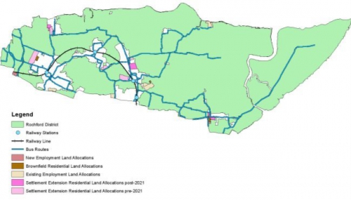
8.25 The existing routes through the district are illustrated in Figure 11 below.
Figure 11: The existing bus network and train stations in the district
8.26 There are also four train stations in the district, one in each of the main towns and a dedicated station for London Southend Airport which opened in 2011. Public transport provision (both bus and train) in the district are privately operated which means that there is a limit as to how much we can influence the level of provision – although it is recognised that some bus routes are funded by Essex County Council. We will, however, continue to work with relevant providers to promote better services for our communities to provide a realistic and viable alternative to private vehicles for commuting and other journeys, to reduce congestion and associated problems. This may require further co-operation with other areas in South Essex and beyond.
8.27 There are a number of existing cycling routes across the district but these are largely fragmented. There are routes along Ashingdon Road, Hall Road and Cherry Orchard Way in Rochford, although this is not continuous, and a partial route along Hullbridge Road between Hullbridge and Rayleigh. Increased opportunities for walking as well as cycling not only provides health and leisure benefits, but can also help reduce car dependency for certain journey types. Cycling was noted by residents, through the early community engagement programme in 2016, to have health benefits. Improvements to walking and cycling provision are supported within Core Strategy policy T6, and should be fully integrated into schemes to encourage communities to cycle wherever possible. Encouraging cycling within and through Rayleigh town centre are, in particular, supported to drive improvements to local air quality in this area, for example improved cycling storage.
8.28 Our current policies seek to support the creation of a safe and convenient network of routes to link homes, workplaces, services and town centres; as well as developing a network alongside the district's rivers. A spine route through the district, and improved connectivity around London Southend Airport, has been identified in the Core Strategy and London Southend Airport and Environs Joint Area Action Plan. Building on this, a number of studies have been prepared to further refine the potential route across the district, predominantly focussing on off-road routes where possible[34]. Further routes to improve safe cycling opportunities in the eastern part of the district are also being explored to connect a number of the towns and villages and local employment opportunities, and green spaces.
8.29 Essex County Council, as the Highway Authority, is supportive of sustainable transport and has prepared an Essex Cycling Strategy[35] for the county which aims to improve the attractiveness of cycling and increase its uptake as a reasonable alternative form of travel to the car. This will be supplemented by an Action Plan for the district which will provide more detail on specific proposals at the local level.
8.30 Travel plans for schemes are required to promote more sustainable travel, where possible. Core Strategy policy T5 requires schemes for 50 or more new homes, and any other types of developments generating trips such as schools and leisure uses, to prepare travel plans. However, Essex County Council's Sustainable Modes of Travel Strategy (August 2016) requires residential travel plans for schemes of 250 homes or more, or where there are existing problems (in line with Essex County Council's Development Management Policies, policies DM9 and DM10). Also, Essex County Council's guidance Helping you create a Business Travel Plan (December 2016) which establishes a threshold of 50 employees or more as a result of the development of new business premises or extensions to existing business premises – or where there will be a significant impact on the local road network, or where existing problems exist. There does however need to be a more cohesive approach to ensure that sustainable travel options – bus and rail, walking and cycling connectivity – are better integrated into all schemes to give real choice to residents.
8.31 The Rayleigh Town Centre Air Quality Action Plan (AQAP) considers different measures that could be implemented to improve air quality within the town centre. This plan recommends that our current policies could be amended or reviewed. A key cause of air quality issues is from congestion and emissions from road traffic as recognised in the Environmental Capacity Study 2015. This study recommends several mitigation measures to counteract any potential increases in vehicle movements, including highway improvements, particularly to reduce congestion, and promoting more sustainable ways to travel. Air quality is considered in more detail in the 'Protecting and Enhancing our Environment' chapter.
8.32 We also have a policy on promoting green infrastructure in the district (Core Strategy policy T7) through the provision of specific greenways across into neighbouring areas; these were identified through the Green Grid Strategy. Green infrastructure is considered in more detail in the 'Supporting Health, Community and Cultural Facilities' and 'Protecting and Enhancing our Environment' chapters.
What are the identified issues?
8.33 The district has high car ownership, and many rural communities are reliant on private transport due to the lack of frequent and reliable alternatives. During the early community engagement programme in 2016, a number of specific issues were identified across the district in relation to sustainable travel choices for communities, including:
- Conflict between walkers and cyclists along Ashingdon Road in Rochford/Ashingdon
- Cycle paths could be provided for example along Southend Road in Rochford; Ironwell Lane in Hawkwell; Shopland Road in Rochford; and in Canewdon and Hockley
- Need to provide appropriate facilities for cyclists
- Improvements to condition of footpaths along the river Crouch, particularly around Hullbridge are needed
- Amendments to certain bus routes are needed, such as rerouting to avoid the Market Square in Rochford
- Impact of buses serving King Edmund School in Rochford on Great Wakering / Little Wakering / Barling
- Improved access to secondary schools for children in Hullbridge such as free bus service
8.34 Bus and rail facilities (other than passenger transport) are privately owned which can limit our ability to influence improvements; these may also be limited by existing infrastructure. We have a significant number of train stations in the district, and there is interchange between bus and rail services, but this could benefit from improvement, for example in relation to London Southend Airport; the new Airport Business Park in Cherry Orchard Way, Rochford; Rochford Market Square; Rayleigh High Street, as well as at the three town centre train stations. The frequency of bus and rail services is summarised within the Highways Baseline Topic Paper 2017. There are also issues at the South Essex level with poor north to south public transport connectivity. To make passenger and public transport an attractive, reliable and viable option for local communities in the future, we will need to carefully consider where we seek to locate new homes and jobs; ensuring that they are well related to existing public transport hubs or networks to promote sustainable travel, or have the potential to develop new hubs or routes. Providing better bus facilities in particular would offer greater choice to those looking to access local employment opportunities across the district, and subsequently benefit local economic growth. We could consider setting a more challenging mode share, for example 30/30/40 (public transport/walking and cycling/private vehicle).
8.35 We will continue to work with relevant private and public transport providers and Essex County Council to promote better services throughout the district; and improve connectivity between different transport modes. This could consist of a review of current routes to increase residents' use of local services or through planning obligations or a Community Infrastructure Levy (CIL) charge on schemes in the future to deliver improvements. This could mean that financial contributions could be sought from different types of development to potentially contribute to the network improvements beyond a development area and secure improvements to routes, including bus stop facilities. We will also need to work in partnership with Essex County Council and Southend Borough Council, as two of the Highway Authorities in Essex, as well as other neighbouring areas, to develop an improved passenger transport offer for our district, which connects to the wider area and meets the needs of our communities.
8.36 Opportunities for walking between homes, schools, local jobs and bus and rail connections are particularly well used in our towns. However, opportunities are more limited in the rural areas of the district although there are numerous public footpaths available for leisure use. Cycling on the whole is more challenging in the district, due to narrow roads within many of our towns and fast, winding country roads in the more rural eastern areas of the district. This can create conflict between cyclists and other road users. There are some off-road routes in the district but these tend to be fragmented. The Environmental Capacity Study 2015 recognises that promoting efficient movement of through-traffic and to encourage more sustainable transport and movement in the South Essex area, as a whole, is a challenge. It recommends that this should be considered on a sub-regional transport impact assessment scale. The Core Strategy supported the provision of a South Essex Rapid Transit (SERT) system as set out in policy T4, although this has not come to fruition.
What are the realistic options?
8.37 Seven options have been identified to support sustainable travel.
|
Option |
Justification |
|
The policy on public transport is considered to broadly be appropriate in promoting and supporting the connectivity of schemes to the public transport network as set out in Core Strategy Policy T3. However, consideration should be given to whether this could be strengthened to ensure that public (and passenger) transport is a key consideration and is fully integrated into all schemes. Improvements to public transport interchanges in key locations across the district and north/ south public transport connectivity across the wider South Essex area should also be supported. This could be supported by a more comprehensive review of public transport and options for improvement to encourage a shift in the way people travel around the district (and beyond) in the future. |
|
We have a current policy on the South Essex Rapid Transit (SERT) which was envisaged as a network of priority bus routes to connect Basildon, Southend, Thurrock and London Gateway Port, and other key development sites and services (Core Strategy Policy T4). This could still be an option considered to be appropriate at the South Essex level, but would require effective co-operation and a clear business case to demonstrate viability over the longer term. |
|
Core Strategy Policy T5 requires new schools, visitor attractions, leisure uses and larger employment schemes to prepare and implement travel plans. Schemes over 50 homes are required to prepare a travel plan. This policy could benefit from updating to reflect Essex County Council's guidance on employment sites in order to take a proportional approach to the requirement for business travel plans. However, it is not considered to be appropriate to increase the threshold for residential travel plans to 250 homes or greater given that the majority of schemes for new homes in the district tend to be below this threshold and would not be captured by an amended policy. |
|
Only schemes over 50 homes are required to prepare a travel plan within Core Strategy Policy T5. If we consider smaller sites to deliver new homes as part of our strategy to deliver new homes in the future, this could have a cumulative impact. The NPPF requires schemes which would generate significant amounts of movement to prepare a plan; our policy could be applied to more schemes, which cumulatively could have an impact. |
|
Our current policy on walking and cycling is considered to be fit for purpose in promoting these alternative modes of travel within schemes (Core Strategy Policy T6). Studies have been and will continue to be developed to explore the potential for new routes within the constraints of the existing highway network. We will continue to work closely with Essex County Council on the development of the Rochford Cycling Action Plan. The policy may need minor amendments as this plan progresses however, for example in response to local air quality issues. This could include strengthening the requirement for cycling storage at destinations. |
|
This approach would involve not supporting improvements to public transport, walking or cycling in policy – particularly the more rural east, and would be contrary to the NPPF. |
(7) Communications Infrastructure
Tell Us More SP3.3: How do we support and deliver improvements to the communications infrastructure across the district over the next 20 years?
Where are we now?
8.38 There is an increasing reliance on digital technology for many aspects of our everyday life, including buying goods and services, and running businesses. Fibre broadband – which can deliver much faster internet speeds than more traditional connections – is becoming integral to enhancing our quality of life and improving the performance, and competitiveness, of businesses. It can enable more people to work from home and work remotely, encourage enterprise and innovation in business growth and enable home businesses to develop. It can also reduce the need to travel. Access to broadband can support the education and skills development for those still at school – as well as those wishing to access higher, or further, education. It can also be used to access public services and healthcare services, and promote tourism opportunities (such as attractions or accommodation) to a wider potential audience.
8.39 Broadband connection speeds can vary significantly across the district; with much lower speeds found in more rural areas. As of October 2017, 90.5% of the district has superfast broadband coverage – defined in the UK as over 24 Mbps – which is a significant increase from 2011[36]. This follows the publication of Britain's Superfast Broadband Future[37] setting out the Government's vision for improved broadband coverage throughout the country which included a commitment of £530m for Broadband Delivery (BD) UK to invest. This commitment has continued, with over £1 billion of new funding to boost the UK's digital infrastructure being committed by the Government in the 2016 Autumn Statement.
8.40 Superfast Essex is a scheme co-ordinated by Essex County Council, as part of the national Superfast Britain programme. The scheme aims to extend fibre broadband coverage to 97% of Greater Essex by the end of 2019. As part of the Superfast Essex scheme, areas of the district have been identified for fibre broadband roll-out, including parts of Canewdon, Foulness, Great Wakering, Hockley, Hullbridge, Rawreth, Rayleigh and Sutton parishes. Improvements to fibre broadband coverage are planned for every parish in the Rochford District by 2019. As of August 2017, 82.71% of homes and businesses in the district now have access to fibre broadband, with a further 12.57% planned to be covered by 2019 and 2.9% additional premises are either existing or planned by providers whose claim is currently under review.
8.41 Our current policy – relating to telecommunications infrastructure in general – is set out in our Development Management Plan within policy DM6. It addresses issues particularly in relation to the location, design and siting of such infrastructure to ensure that there is adequate provision whilst (particularly in rural and potentially sensitive areas) balancing this against potential impacts on the built and natural environment. This approach is supported by the NPPF (paragraph 43 in particular).
What are the identified issues?
8.42 Development Management Plan policy DM6 addresses telecommunications infrastructure in general, but does not specifically refer to broadband. Given that access to fast and reliable broadband is now seen as an essential part of everyday life – at home, at work and at school – it is pertinent to have a policy which refers specifically, and in appropriate detail, to the provision of broadband infrastructure. This will ensure that broadband is a requirement for all new commercial and residential schemes in the district.
8.43 The availability and reliability of fast broadband varies across the district. Some rural areas, in particular, have poor or no broadband connectivity, which may have an impact on both the quality of life of residents, and the willingness of businesses to locate in such areas. This was an issue raised by residents in the more rural parts of the district during our early community engagement in 2016. Such areas may benefit from Superfast Essex and similar roll-out schemes, but policies may need to consider how rural connectivity can be improved, including requiring new developments in these areas to incorporate suitable broadband infrastructure.
What are the realistic options?
8.44 Four options have been identified for communications infrastructure.
|
Option |
Justification |
|
A. Retain the existing policy on telecommunications infrastructure |
The existing policy is considered to be generally fit for purpose, and provides a sufficient basis for the determination of a planning application relating to telecommunications infrastructure. However the existing policy does not take a proactive approach to new technologies, and in particular lacks specific reference to broadband infrastructure. |
|
(5) B. Amend the existing policy to include specific reference to improving broadband and mobile coverage |
As stated above, the existing policy is sufficiently comprehensive and detailed providing the necessary guidance to successfully determine a planning application, however it is very passive. The policy could be made more proactive to seek to improve broadband and mobile coverage in areas designated as lacking for the benefit of the local and rural economies and communities. The policy has room to expand in order to introduce a standard requirement for new developments to install fibre-to-premises cables during their construction to ensure that all new developments for homes and businesses have suitable broadband provision to future proof them. As an alternative a new policy could be developed specifically to address the issue of broadband and enable flexibility to take into account any technological advances. |
|
C. Ensure that all commercial and residential developments over a certain threshold are conditioned to deliver appropriate broadband infrastructure |
Ensuring that all commercial and residential developments, above a threshold, provide broadband infrastructure would help to ensure that the basic needs of the future occupants of these buildings are met with regards to broadband connectivity. One way to achieve this would be through the use of a condition attached to any relevant planning consent which requires agreement of details relating to the provision of broadband infrastructure as part of, and serving, the approved development. |
|
D. Do not have a policy on telecommunications infrastructure |
We could rely on national policy for guidance on development of telecommunications infrastructure in the district, however a specific local policy strengthens our ability to ensure that any proposed telecommunications infrastructure is sensitive and acceptable, and may help to deliver improvements to the wider telecommunications connectivity of the district. |
(113) Water and Flood Risk Management
(6) Tell Us More SP3.4: How do we address water and flood risk management over the next 20 years?
Where are we now?
8.45 Development within areas at risk of river and sea flooding should be avoided (flood zones 2 and 3) as defined by the Environment Agency through the application of the sequential and exceptions test outlined in national policy. We have a Strategic Flood Risk Assessment (SFRA) for South Essex which is a requirement of national policy which assesses the flood risks posed and outlines the main hazard zones in order to further aid the planning process. However due to changes in the Environment Agency's climate change allowances, this is in the process of being updated as part of a joint project with neighbouring authorities.
8.46 The Environment Agency has also worked with other local authorities in Essex and Suffolk to produce a Shoreline Management Plan. The Shoreline Management Plan is a high level document that forms an important element of the strategy for flood and coastal erosion risk management. As noted within the Environmental Capacity Study 2015 the Essex and South Suffolk Shoreline Management Plan policy is to hold the line with maintaining or upgrading defences along the coast. We are committed to working with the Environment Agency to ensure that the district continues to be subject to an appropriate level of protection. The Coastal Protection Belt is considered in more detail in the 'Protecting and Enhancing our Environment' chapter.
8.47 Flooding can result in significant damage to properties and threaten human life. To counteract these risks, the NPPF requires that flood risk is taken into account at all stages of the planning process. In plan-making, Local Planning Authorities apply a sequential approach to site selection so that any development is, as far as reasonably possible, located where the risk of flooding (from all sources – including surface water, groundwater, tidal and fluvial) is lowest, taking into account climate change and the vulnerability of future uses to flood risk.
8.48 We seek to avoid inappropriate development by appraising, managing and reducing the risk in the areas prone to flooding, as set out in the Core Strategy. Policy ENV3 enforces the principle that we seek to direct development away from areas at risk of flooding, and does so by applying the sequential test and exceptions test, where necessary. Proposed development on previously developed land located in flood zone 3 will however be permitted if it enables a contribution towards our requirement for new homes that would otherwise require the reallocation of Green Belt land, providing it can pass the necessary tests and accommodate flood defence infrastructure.
8.49 Parts of the district are also susceptible to surface water flooding which can result from heavy or prolonged rainfall events overloading existing drainage systems, and fast run-off over impermeable surfaces which prevents the water from infiltrating into the ground. A South Essex Outline Water Cycle Study was prepared in 2011which identifies key constraints on housing and employment growth planned within Basildon Borough, Castle Point Borough and Rochford District that may be imposed by the water cycle and how these can be resolved. The Environmental Capacity Study 2015 recommends that the Water Cycle Study is updated to take account of any additional new homes that may be planned for in the future. Similarly, the South Essex Surface Water Management Plan 2012 sets out a co-ordinated approach to managing surface water within South Essex (encompassing Basildon Borough, Castle Point Borough and Rochford District).
8.50 Sustainable Drainage Systems (SUDS) offer an alternative approach to drainage within developed areas, which are promoted within our Core Strategy and Development Management Plan. SUDS can help to reduce flooding by controlling surface water run-off as close to the source as possible, before the water enters the watercourse. SUDS features include above ground infrastructure such as swales, filter strips, basins, ponds and wetlands etc., and below ground infrastructure such as pipes, soakaways and underground storage structures. Such systems can also protect water resources and improve wildlife interests of developments. Any development should also not increase water pollution.
8.51 Core Strategy policy ENV4 requires SUDS to be incorporated into all residential schemes of more than 10 homes. However, there may still be occasions where smaller developments have the potential to give rise to concerns in respect of surface water flooding, particularly in areas that have been identified as being susceptible to such flooding, including through Surface Water Management Plans which identifies a number of critical drainage areas (CDAs) in the district. New developments cannot address any pre-existing surface water flooding issues, as set out in the Surface Water Management Plan, although financial contributions could be sought to improve surface water drainage infrastructure through a standard CIL charge for example (considered in more detail below).
8.52 Other instances where there may be a perceived risk of surface water flooding include where historical instances of such flooding have been documented. Development Management Plan policy DM28 therefore requires schemes of 10 homes or fewer to submit a flood risk assessment where there is a perceived risk of flooding from surface water run-off, to ensure that the risk is appropriately managed. Essex County Council is the Lead Local Flood Authority and is responsible for overseeing the management of local flood risk including groundwater flooding, surface water (rainfall) runoff, or ordinary watercourses (streams and ditches). Essex County Council has also produced a Sustainable Drainage Systems Design Guide[38] in 2016 to assist in the design of schemes. SUDs should also be required on all major schemes, not just residential however.
8.53 The impact of climate change on water supply is a factor that needs to be taken into consideration. The Environmental Capacity Study 2015 notes that there is a surplus of supply in the Essex Water Resource Zone, and that water resources are adequate for proposed and additional growth, and without any adverse effects on ecological quality. The Study also considers water treatment, and recognises that there are two waste water treatment facilities in the district, which are not likely to have any capacity constraints up to 2032. There is however uncertainty about the capacity of the facility in Southend.
What are the identified issues?
8.54 Flooding can cause significant damage to property and endanger human life – both from watercourses and from surface water run-off. Concerns about both coastal and surface water flooding were raised by residents during the 2016 early community engagement programme.
8.55 The Environment Agency is responsible for advising on schemes that are potentially within flood zone 2 or 3. Parts of Great Wakering and other existing settlements are in areas at risk of flooding as defined by the Environment Agency. It would not be appropriate to relocate these affected areas due to the detrimental impact this would have on community cohesion and the viability of such an approach. Nonetheless, we continue to work closely with our partners to safeguard the flood risk area, and direct development away from these areas wherever possible. The Environmental Capacity Study 2015 highlights that there are coastal erosion threats in the district and a likely increased need for increased flood protection measures as result of climate change.
8.56 The type of flood risk defined by the Environment Agency's flood zones from rivers and the sea differs from surface water flooding but can sometimes be confused with these identified risk areas. Essex County Council's role as the Lead Local Flood Authority is to manage surface water flooding. This type of flooding tends to be more localised and happens quickly after a rainfall event, which means that it can be difficult to issue flood warnings. SUDS schemes that are implemented with any new development needs to ensure that any run-off as a result of the development would not increase above the level if the development had not occurred. Preferably the run-off levels would be reduced. The Surface Water Management Plans identify broad critical drainage areas to predict the likelihood of surface water flooding within an area. The Environmental Capacity Study 2015 notes that the impermeable geology structure in the west of the district limits opportunities for some types of SUDS, however, there are a number of above ground options that can be implemented to mitigate against any risk.
8.57 The impact of any increases in water resource demand, waste water treatment capacity and any impact on the biodiversity of water quality (chemical and ecological) need to be considered, as recognised in the Environmental Capacity Study 2015. However the sensitivity of water resources is considered to be low, water quality low to medium sensitivity and water treatment and sewerage medium sensitivity. Flood risk on the other hand is considered to be high and medium sensitivity due to the coastal nature of the district.
What are the realistic options?
8.58 Four options have been identified in relation to minimising flood risk.
|
Option |
Justification |
|
Core Strategy policy ENV3 aims to resist inappropriate developments in areas at risk of coastal flooding, wherever possible, following the sequential and exceptions test approach. The exception is some brownfield (previously developed) land. This is in line with national policy and is considered to be an appropriate policy position. |
|
If this policy was revised, the brownfield (previously developed) land exception in flood zone 2 and 3 could be removed. However the approach in policy ENV3 is considered to an appropriate balance in certain circumstances to avoid development on greenfield land elsewhere. |
|
SUDS are crucial in keeping runoff and discharge rates similar to those that would naturally occur in order to mitigate possible flash flooding events. Core Strategy policy ENV4 sets out when schemes would be required to include a SUDS element. This is supplemented by Development Management Plan policy DM28 covers which relates to smaller developments. These policies are considered to be fit-for-purpose in managing surface water flood risk from new developments, but could be combined into one succinct policy. |
|
This is not an appropriate approach and would be contrary to national policy. |
(6) Renewable Energy Generation
Tell Us More SP3.5: How can we continue to support and encourage renewable energy generation over the next 20 years?
Where are we now?
8.59 Supporting alternative energy sources is important to help address climate change, and is an approach supported by national policy. There is a need to reduce energy and water consumption not only for the benefit of our local environment, but also for the global environment. We are keen to reduce the impact of any schemes on the environment through a variety of measures, including renewable energy. The NPPF also recognises that supporting such schemes can reducing vulnerability and improve adaptability to climate change.
8.60 Over the last five years there have been a few applications for the installation of solar panels on a scale not seen before in the district – including one in Canewdon and one to support London Southend Airport's operations. Any large-scale renewable energy scheme would need to be considered in terms of the potential impact on the landscape character and the ecological importance of where it is proposed, and any impacts on visual amenity, as set out in Core Strategy policy ENV6. We encourage small-scale renewable energy schemes, including additions to residential properties such as solar panels, photovoltaic cells and geothermal heat pumps. We would not; however, support biomass heating as these boilers can produce more pollution than similar gas-based systems. Core Strategy policy ENV7 supports such proposals taking into consideration the location, scale, design and other factors such as ecological impact.
8.61 New schemes have the potential to deliver secure, decentralised, renewable or low carbon energy sources, which are likely to be more cost effective to fit at the construction stage. Onsite renewable and low carbon energy generation are particularly encouraged for both residential and commercial schemes to lower emissions and reduce their carbon footprint. Core Strategy policy ENV8 requires schemes of five new homes or more, or 1,000 square metres or more to secure at least 10% of their energy from decentralised and renewable or low carbon sources (subject to viability).
8.62 The Rayleigh Town Centre Air Quality Action Plan (AQAP) considers different measures which could be implemented to improve air quality within the town centre. One such measure is encouraging the installation of electric vehicle charging points within new developments to promote the use of electric vehicles. There are however currently very few electric vehicle charging points in the district. The provision of electrical upstands and outlets for the recharging of vehicles would typically not require planning permission, provided that certain restrictions on dimensions and siting are met. However, we do not currently have a policy to deal with any planning applications for charging points which exceed these allowances.
What are the identified issues?
8.63 Large scale renewable energy projects such as the installation of a solar or wind farm will likely require vast areas of land. Given that the majority of the district's open land is designated as Green Belt, and that significant areas are also protected for their historic, ecological or wildlife importance, any large scale project in these areas has the potential to cause significant harm to the preserved character, visual amenity or special ecological contribution that these areas possess. The purposes of the Green Belt such as the preservation of openness may also be difficult to maintain. The NPPF however at paragraph 91 notes that many renewable energy projects will be considered inappropriate development in the Green Belt. It would be up to the developer to demonstrate that very special circumstances merit such development.
8.64 Electric vehicles (EV) are becoming an increasingly more common sight on our roads, and with manufacturers diversifying the range of choice of electric vehicles, the trend for increased uptake is set. As a result, the means to charge these vehicles away from the home will become ever stronger. Monitoring the need for electric vehicle charging points in urban centre car parks needs to be ongoing to enable us to meet the need as and when it becomes high enough to be economically viable to install the charging points. As discussed above, the provision of an electric vehicle charging point would typically not require planning permission, unless certain restrictions on dimensions and siting were not met. However, it may be that changes to consumer trends mean planning applications for electric vehicle charging points increases.
8.65 The impact of electric charging points within existing car park spaces on the availability of parking for non-electric vehicles must also be considered. It may be that to introduce electric charging points where the demand is modest would displace other car park users and exacerbate parking issues. It is therefore important to ensure that the provision of electric vehicle charging points is appropriate and justified at the time of doing so. However, it must be noted that in cases where providing a charge point would be permitted development, there would be no scope to consider such an impact.
What are the realistic options?
8.66 Three options have been identified to support renewable energy provision within the district.
|
Option |
Justification |
|
Core Strategy policies ENV6, ENV 7 and ENV 8 are considered to be fit-for-purpose in addressing proposals for renewable energy generation and should be retained. |
|
As and when the need arises, which could be within the next plan period, our current policy could be amended or a new policy be proposed to manage the introduction of electric vehicle charging points in car parks and other appropriate areas such as new residential and employment developments. |
|
Such an approach is not considered to be appropriate as national policy requires us to consider the impact of renewable energy schemes. |
(14) Planning Obligations and Standard Charges
(2) Tell Us More SP3.6: How do we deal with planning obligations and standard charges to support the delivery of new homes and jobs over the next 20 years?
Where are we now?
8.67 Promoting sustainable development is the key thrust of the NPPF. As part of this, we need to consider viability and the potential implications of any policy requirements on the deliverability of a scheme. This includes ensuring affordable housing provision, standards, infrastructure contributions, and other contributions (including financial), still provides a competitive return to landowners and developers (paragraph 173). This is recognised in the Core Strategy. The planning system enables us to require developers to make payments or undertake additional works to mitigate the impacts of new development, using a system known as 'planning obligations' involving a legal agreement between developers and local authorities (also known as a S106 agreement).
8.68 Guidance on appropriate planning obligations is set out in the NPPF. Paragraph 204 sets out three tests that any obligations must pass:
- necessary to make the development acceptable in planning terms;
- directly related to the development; and
- fairly and reasonably related in scale and kind to the development.
8.69 The NPPF (paragraph 203) emphasises that planning obligations should only be used where it is not possible to address unacceptable impacts through a planning condition. For conditions to be acceptable, where necessary, they need to be enforceable, precise and reasonable in all other respects (paragraph 206).
8.70 We have used planning obligations to secure the provision of infrastructure improvements, such as highway improvements, to meet education needs and to ensure affordable housing is delivered. There are concerns that planning obligations cannot address all the infrastructure deficiencies that will be caused by new development, particularly the incremental impact of smaller schemes, which individually do not warrant the provision of planning obligations, but have a significant cumulative impact. It was envisaged within the Core Strategy that we would produce a standard charges document under the Community Infrastructure Levy (CIL) regulations, which would set out a simple formula to calculate the contributions for each scheme coming forward through the planning system. This is still our intention.
8.71 Core Strategy policy CLT1 sets out the requirement for developers to enter into legal agreements in order to secure planning obligations to address specific issues relating to developments, including requisite on-site infrastructure and the provision of on-site affordable homes. It also refers to the preparation of a standard charges document and the application of standard charges for certain types of infrastructure as detailed in Appendix CLT1. Our current position with regard to S106 agreements (and other secured funding sources for infrastructure) is detailed within our Infrastructure Delivery Topic Paper 2017. This topic paper also sets out our approach to engaging with infrastructure and service providers, which we are required to do in a proactive, on-going manner as required under the Duty to Co-operate. More information on the Duty is set out in our Duty to Co-operate Topic Paper 2017.
What are the identified issues?
8.72 Any planning obligations required from new development must meet the three tests set out in the NPPF to be acceptable. In particular they need to be directly related to a development to mitigate the expected impacts of the development itself, and cannot be used to rectify existing infrastructure deficiencies. Viability is a key consideration.
8.73 The Housing White Paper supports small and medium-sized house builders, and the delivery of small and medium-sized sites to deliver new homes more quickly than larger house builders. However, small schemes may not merit us to require planning obligations to make the development acceptable which means that the cumulative impact of such schemes cannot be captured and effectively mitigated against. This is an issue which has broadly been raised during the programme of early community engagement we undertook in 2016. Similarly even if a standard charge was in place, it is not guaranteed that these funds would be spent on specific infrastructure related to a specific scheme, as any funds must be spent on agreed infrastructure projects in line with the CIL regulations, which could be anywhere across the district depending on prioritisation of projects. Any future changes to the CIL regulations will also need to be carefully considered and accounted for.
8.74 Certain infrastructure is more vulnerable than others to viability constraints within the planning system, in particular the requirement to deliver affordable homes. An appropriate balance therefore needs to be struck.
What are the realistic options?
8.75 Two options have been identified for planning obligations and standard charges.
|
Option |
Justification |
|
Core Strategy policy CLT1 and Appendix CLT1 clearly set out when standard charges would be applied to schemes for which infrastructure types, although these may require updating. It is still considered to be a suitable approach to acquiring funds to direct infrastructure improvements across the district. It is still our intention to prepare a standard charges document. |
|
It is necessary to continue to set out our position on planning obligations and standard charges – particularly our intention to prepare a standard charges document. The current policy however may require updating. |
[36] Think Broadband district profile and speed test sample mapping available from: www.thinkbroadband.com