Issues and Options Document
(5) 4 Our Spatial Challenges
(13) National Picture
4.1 At the national level there is a clear agenda for growth to address the historic under delivery of new homes to meet our country's needs and to support our future economic prosperity. For planning purposes this is enshrined in the National Planning Policy Framework (NPPF) published in 2012, followed by the Planning Practice Guidance (PPG) in 2014. Other relevant policy documents include thePlanning Policy for Traveller Sites (PPTS) and National Planning Policy for Waste (NPPW). The preparation of planning policies at the local level is at the forefront of the NPPF to ensure that the planning system principally remains plan-led where a Local Planning Authority – such as Rochford District – have their own locally specific policies that are up-to-date and in accordance with national planning policy and guidance.
4.2 The achievement of sustainable development is the primary thread that runs throughout the NPPF, recognising the mutual dependency between key environmental, economic and social considerations. Paragraph 14 of the NPPF establishes the presumption in favour of sustainable development, for both plan-makers and decision-takers. This approach seeks to encourage a positive approach to balancing the need for new homes and jobs against other considerations set out in the NPPF to deliver national growth aspirations and speed up the planning system.
4.3 The Government has also set up 39 partnerships (Local Enterprise Partnerships) across the country to determine economic priorities within specific areas, investing in and delivering projects that will drive growth and create new jobs locally. These are business-led, public/private partnerships which cover extensive areas across the region. The South East Local Enterprise Partnership (SELEP) covers Essex, Southend, Thurrock, Kent, Medway and East Sussex and aims to drive economic growth[20]. SELEP has prepared a Strategic Economic Plan (due to be refreshed by the end of 2017) which sets out its ambitions to enable the creation of more private sector jobs, more new homes and invest heavily in accelerated growth, jobs and homebuilding through the Growth Deal. Through the Growth Deal, SELEP can direct Government monies towards specific projects across the LEP area – including schemes to deliver new homes, jobs and infrastructure – which can competitively demonstrate a growth return for the investment. A new business park in Rochford, for example, is being delivered with investment from SELEP to support the development of land for business and new local job opportunities.
4.4 In terms of growth the NPPF,supported by the PPG,sets out how Local Planning Authorities should work out how many new homes are needed within their area and plan positively for those new homes. In simple terms the need for new homes is calculated using a broad methodology across a Housing Market Area, and set out in a Strategic Housing Market Assessment (SHMA). As a Local planning Authority, we sit within the South Essex Housing Market Area. This is a 'policy off' position which means that it identifies what an area's unconstrained need is, irrespective of any constraints such as environmental capacity or infrastructure restrictions. It is then the responsibility of the plan-making process to identify whether an area can meet this need in full or whether it will need help from its neighbours. The NPPF paragraph 47 requires us to significantly boost the supply and choice of new homes; with our ability to demonstrate a rolling five year supply of land for new homes being a key requirement. The Government however is proposing to change the way that the need for new homes is calculated. As a Local Planning Authority, we will need to ensure that we deliver the right homes in the right places.
4.5 Delivering new jobs and supporting business and inward investment are important considerations within the national planning agenda to support the country's economic growth. The NPPF identifies policies to deliver and support a strong and competitive economy, and emphasises that the planning system – both plan-makers and decision-takers – should place significant weight on the need to support economic growth. We need to identify the amount of new land needed for business within a Functional Economic Area, which is set out in an Economic Development Needs Assessment (EDNA). We sit within the South Essex Functional Economic Area, and have a close relationship with our neighbouring areas which have different, complementary strengths to us. Whilst the NPPF requires us to identify a clear strategy for delivering sustainable economic growth, facilitate new land for business development, support existing business sectors and plan for changes in sectors, and identify priority areas for regeneration and infrastructure investment, we must not over-burden investment in business.
Challenge – how do we deliver new jobs that residents can access?
4.6 Infrastructure is critical to support sustainable economic growth. The NPPF recognises that through plan-making, we need to need to work with infrastructure and service providers as well as Essex County Council and neighbouring authorities to deliver strategic and local infrastructure needs. This includes assessing the quality and capacity of infrastructure for transport (including sustainable travel choices), water supply, wastewater and its treatment, energy (including heat), telecommunications, utilities, waste, health, social care, education, flood risk and coastal change management, and its ability to meet forecasted demands. Given our location in South Essex, and our relationship with the strategic road and rail network, we need to work closely with our neighbouring areas to ensure that our plans across the sub-region take into consideration future projected growth in homes and jobs.
Challenge – how do we deliver infrastructure to support new homes and jobs?
4.7 The NPPF at paragraph 181 makes it clear that as a Local Planning Authority we have a Duty to Co-operate as part of the plan-making process. We must demonstrate how we have worked effectively and collaboratively throughout the plan-making process with a range of organisations (including neighbouring areas, and infrastructure and service providers) to ensure that any identified strategic and cross boundary issues have been addressed within their own local development plans. The Duty to Co-operate is an important legal test – which is set out in the Localism Act 2011 – that we have to pass when preparing our plans. Guidance on how to apply the Duty to Co-operate is set out in the PPG, and how we as a Local Planning Authority have applied the requirements of the Duty are detailed within the Duty to Co-operate Topic Paper 2017.
Challenge – how do we work with our neighbours to meet the requirements of the Duty to Co-operate?
(19) South Essex Picture
4.8 Being part of the South Essex sub-region means that as a district we have a close relationship with our neighbouring areas. Sharing land boundaries predominantly with Southend, Castle Point and Basildon Borough Councils within South Essex, a land boundary with Chelmsford City and a marine boundary with Maldon District, means that we have a number of other authorities to engage with on issues that are strategic and cross boundary in nature. We have a long, successful history working with our neighbouring authorities, particularly in South Essex, to deliver on local planning matters as detailed within the Duty to Co-operate Topic Paper 2017.
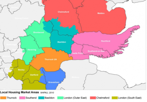
4.9 As a district, we share a sub-regional Housing Market Area with Southend, Castle Point, Thurrock and Basildon Borough Councils; as identified in successive SHMAs – most recently the 2016 South Essex SHMA and 2017 Addendum. The SHMA also identifies that Rochford District sits within a local Housing Market Area with Southend and Castle Point Boroughs, as illustrated in Figure 8.
Figure 8: Local Housing Market Areas in South Essex (source: 2016 South Essex SHMA)
4.10 As part of the Duty to Co-operate, the five South Essex authorities and Essex County Council have signed a South Essex Strategic Planning Memorandum of Understanding (MoU) to provide a framework setting out the co-operation and engagement arrangements, roles and inter-relationships between the relevant authorities. The strategic, cross-boundary matters that have been agreed are:
- Housing (including Gypsy and Travellers)
- Economic Growth and Employment
- Retail
- Green Belt
- Climate Change
- Green Infrastructure/Green Grid
- Transport and Access
- Health and Well Bein
- Minerals and waste
Communications Infrastructure
4.11 Our neighbouring Local Planning Authorities however are at different stages of plan-making, and have their own challenges and opportunities.
Basildon Borough Council
4.12 Located to the west of our district, Basildon Borough has nearly 7,000 hectares of land designated as Metropolitan Green Belt, as identified in their 1998 Local Plan. The Borough covers an area of approximately 11,000 hectares and includes the urban areas of Basildon (including Laindon and Pitsea), Billericay and Wickford, with six villages and thirteen Plotland settlements. The A127 – which is a strategic route serving South Essex – runs through Basildon Borough, and the Council's enterprise corridor, which serves as an important driver for economic growth, is located on the southern boundary of this road. The Borough's population is served by two train lines; the London Fenchurch Street and the London Liverpool Street lines. The Council is working towards the submission (final) stage of its plan-making to deliver new homes, jobs and infrastructure need to support growth in the Borough. Basildon Borough Council is seeking to meet its own needs as far as possible, but has previously indicated that it may not be able to meet all its Gypsy and Traveller pitch requirements within its own boundary. It has also proposed improvements to the A127, including the delivery of a new junction and spur to link to the A130 in Rochford District. The Council anticipate that their pre-submission (final draft) version of their Local Plan will be published in early 2018.
Castle Point Borough Council
4.13 Some 56% of Castle Point Borough's land area is designated as Metropolitan Green Belt in their 1998 Local Plan – equivalent to 2,750 hectares – and is tightly drawn around the existing urban areas of Benfleet, Hadleigh and Thundersley. The Council's draft New Local Plan 2016 sought to meet a fraction of its need identified in the SHMA; with fewer new homes planned than previously on its Green Belt land. This approach however did not meet the legal requirements of the Duty to Co-operate however, as found by a Planning Inspector in January 2017 (further detail is provided in the Duty to Co-operate Topic Paper). If Castle Point Borough Council can effectively demonstrate that it is unable to meet all of its need for new homes within its own boundaries, it will need to work closely with neighbouring areas such as Rochford District to identify and agree an approach to delivering any potential unmet need. Similar to Rochford District, the Borough is served by the A13, A127 and A130, however, in terms of rail access the Borough is served by the London Fenchurch Street line. In terms of plan-making, the Council is still in the process of preparing its Local Plan following withdrawal of its submission (final draft) version in early 2017.
Chelmsford City Council
4.14 Chelmsford is the main settlement within the Council's administrative area with a number of smaller towns, villages and hamlets dispersed throughout. Nearly 38% of the Borough – located at the southern end of the City's administrative area – is designated as Metropolitan Green Belt. Chelmsford has not undertaken a comprehensive review of its Green Belt to date (as of July 2017), but has sought to deliver on its need for new homes and jobs in areas outside the Green Belt. Chelmsford City published its Preferred Options version of their Local Plan, which proposes to meet the city's needs (plus a 20% homes buffer to provide flexibility) within its own boundaries. Chelmsford city is served by a number of strategic roads, including the A130, which connects South Essex with the city, and the A12. North to south connectivity, particularly in terms of public transport provision, is limited and disjointed which does not make an attractive alternative to private vehicles. Chelmsford City Council are advanced in their plan-making and are anticipating on publishing their pre-submission (final draft) local plan in early 2018.
Southend Borough Council
4.15 Southend Borough is predominantly urban encompassing the settlements of Leigh, Chalkwell, Westcliff, Prittlewell, Southchurch, Southend, Thorpe Bay and Shoeburyness. However, of the 4,163 hectares of land area in the Borough, some 610 hectares is designated as Metropolitan Green Belt. Southend Borough is served by both the A127 and A13, and similar to Rochford District is constrained by the capacity of the strategic and local road network. The Borough is also served by the London Fenchurch Street and London Liverpool Street train lines. Given our location in South Essex we have a close relationship with Southend as an area, in terms of flows of residents to access jobs, schools, healthcare, open spaces and other facilities. The Borough's 2007 Core Strategy seeks to deliver the housing and employment needs set out in the East of England Plan up to 2025 whilst retaining the Green Belt around the urban area. The Council is at the early stages of its formal review of it local development plan, however it is possible that given its constraints it may be unable to meet all of its need for new homes and jobs within its own boundaries. As with Castle Point, if this is the case Southend Borough Council will need to work closely with other Local Planning Authorities as part of the Duty to Co-operate to address any potential unmet need.
Rochford District Council
4.16 Our district consists of the three main towns of Rayleigh, Hockley and Rochford and the villages of Hullbridge, Canewdon and Great Wakering with a number of smaller settlements located within and outside the Green Belt. Our Core Strategy (adopted December 2011) identified a need to reallocate a small proportion of our Green Belt land to meet the need for new homes and jobs, as set out in the East of England Plan up to 2025. The Allocations Plan (adopted February 2014) subsequently allocated a number of specific sites to meet this need. Over 74% of the District's land mass remains designated as Green Belt land, excluding Foulness Island. Similar to other areas in South Essex we are served by a number of strategic roads, including A130, A127 and A13, with capacity limitations and a constrained local road network. Given the rural nature of the district, public transport provision can be limited. London Southend Airport and a new Airport Business Park are located within our district, acting as catalysts to support local economic growth.
Thurrock Borough Council
4.17 The Borough extends across an area of 16,500 hectares; over 65% of which is designated as Metropolitan Green Belt. There are several main settlements in the Borough, including Grays and Tilbury, with a number of smaller villages and several major developed sites located in the Green Belt. The Council's Core Strategy (adopted December 2011) seeks to protect the Green Belt whilst permitting a limited number of site-specific releases to meet housing, education and employment needs where necessary over the plan period. Thurrock Borough Council is at the early stages of plan-making, with an Issues and Options Part 1 published in early 2016. A delay in a decision on the preferred route of the Lower Thames Crossing has contributed to a delay in progressing the Council's Local Plan, however this has now been determined. The Borough benefits from its close proximity to London, links to the strategic road network (such as the M25) and the presence of Tilbury Docks, London Gateway and Intu Lakeside which serve to drive economic growth.
Challenge – how do we work with our neighbouring areas to address strategic, cross boundary issues, and in particular any unmet need for new homes and jobs?
Relationship with London
4.18 Given our district's proximity to London, we need to be mindful of the city being a significant attractor for employment for those living in South Essex and therefore the need for some residents to commute. As a Housing Market Area, South Essex will have its own need for new homes and jobs to meet, and so will London. The most recent London Plan is going through a process of review with A City for All Londoners[21]being consulted on in 2016. One of the key challenges will be ensuring that London as a city takes a positive and proactive approach to meeting as much of its own needs within its own boundaries as far as possible. A proportion of London is designated as Green Belt, and so as a South Essex Local Planning Authority we need to work closely with the Greater London Authority in the review of the new homes and jobs needed for London through the Duty to Co-operate.
Challenge – how do we work with other areas, such as London, to address strategic, cross boundary issues, and in particular any unmet need for new homes and jobs?