Issues and Options Document
(6) 3 Our Characteristics
(4) Introduction
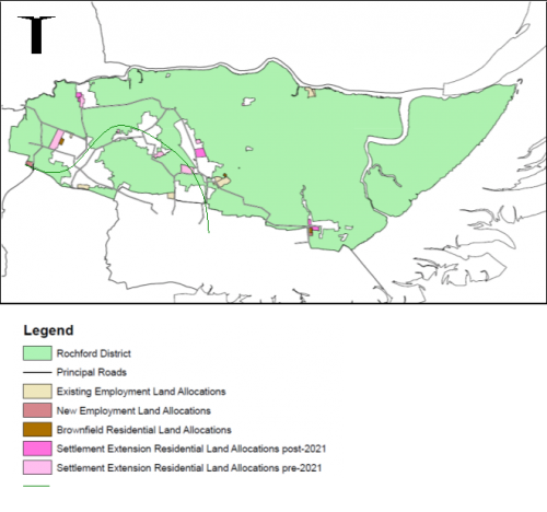
3.1 Located east of London, our district is situated on a headland between the River Thames and River Crouch, and is bounded to the east by the North Sea. We have land boundaries with Basildon, Castle Point and Southend Borough Councils, as well as marine boundaries with Maldon District and Chelmsford City Councils. Our district has links to the M25 via the A127 and has a direct rail link to London. In 2015, the area was home to an estimated 85,144 people dispersed across a number of settlements – the three largest of which are the towns of Rayleigh, Rochford and Hockley. The main settlements in the district and the key strategic transport routes connecting us to neighbouring areas, London and beyond are illustrated in Figure 1.
Figure 1: Map of the district
3.2 The area has a total land mass of 16,800 hectares, including Foulness Island, which is predominantly rural in nature. This is reflected in the fact that 12,481 hectares, which excludes Foulness Island, are designated as Metropolitan Green Belt. Large areas of the district are of ecological importance, with Sites of Special Scientific Interest totalling 2,268 hectares and Natura 2000 Sites exceeding 2,000 hectares. The area is rich in heritage and natural beauty, with many miles of unspoilt coastline and attractive countryside. There are more than 200 sites of archaeological interest, 14 Ancient Woodlands and several nature reserves across the district.
(7) Our Economy
Key Economic Characteristics:
- We are home to around 3,320 businesses, with 95% employing fewer than 10 people, and the highest number of surviving start up businesses in Essex
- London Southend Airport is a regionally important and expanding airport, with over 93,000m2 of additional employment floorspace being delivered at the Airport Business Park in Rochford, including an innovation centre
- We have a strong relationship with Southend and London. Unemployment is very low and we have low deprivation levels
- Skills levels are above average relative to the rest of Essex, with 92% of the working age population having a minimum qualification of NVQ level 1, and we have an increase in apprenticeship starts year on year
3.3 As a district we are part of South Essex, which is a national priority area for growth and regeneration[13]. The area home to around 3,320 businesses and we have a low unemployment rate[14]. London Southend Airport has expanded in recent years including an extension of the runway into neighbouring Southend Borough, the development of a new terminal building and dedicated railway station with direct links to central London via the Southend Victoria to London Liverpool Street Line.
3.4 As of 2016, the district had 26,138 m2 of office floorspace and over 1 million m2 of manufacturing, industrial and warehouse floorspace. The available floorspace is to grow considerably following the construction of Airport Business Park located along Cherry Orchard Way in Rochford which began in early 2017.
3.5 We have a small, but productive, and enterprising economy. Although our workforce does not have significant levels of 'high skills', the skills level which underpins the local economy is generally above average compared to the rest of Essex, and supports a healthy share of knowledge-driven jobs. Around 92% of the working age population in the district has a minimum qualification of NVQ level 1. Skills that are in demand include communication, teaching and customer services. The workplace and resident earnings in the district are below average compared to Essex and the UK.
3.6 The area is a generally prosperous part of the country, despite only a modest share of resident 'knowledge workers', the typically higher paid employees. This is reflected in reasonably low deprivation, excellent health conditions among our population (although some pockets of poorer health in the more urban areas are evident), and one of the lowest crime rates in the country.
3.7 The proximity of Southend to the south of the district and the relationship between this urban area and our predominantly rural district has a considerable impact upon our characteristics. Southend is the most populated area in Greater Essex and is one of the largest retail centres in South Essex, attracting consumer expenditure from a wider area and contributing to the leakage of spending out of the district. The retail catchment area of Southend overlays those of all of the district's centres.
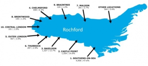
3.8 In addition, Southend provides a range of employment opportunities and is within easy commuting distance of a large proportion of our population, and vice versa. As we are located to the east of London and benefit from a direct train link, a significant proportion of our working age population is also within easy commuting distance of the city. As such, we have a particularly strong relationship with London and Southend, and contribute to workforce flows between other areas in Essex, as illustrated in Figures 2 and 3
Figure 2: Travel to work outflows from 2011 Census
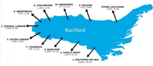
Figure 3: Travel to work inflows from 2011 Census
3.9 In 2015, the district had an unemployment rate of approximately 6% which is slightly higher than the county average of 4.9% but is a reduction from 2013 levels of approximately 8%. The percentage of adults aged 16-64 who were in employment in 2015 was 74.7%, just below the county average of 76.2%[15]. It is however estimated by the Office for National Statistics (ONS) that between 2015 and 2025 the proportion of the working age population will fall slightly from 55% to 52%.
3.10  Overall we
have quite a diverse employment base with a large number
employed in the public sector or financial and business
services. A breakdown of the proportion of district residents
employed in certain sectors is illustrated in the Figure 4.
Overall we
have quite a diverse employment base with a large number
employed in the public sector or financial and business
services. A breakdown of the proportion of district residents
employed in certain sectors is illustrated in the Figure 4.
3.11 In 2014-15, there were 740 apprenticeship starts by our residents compared to 560 starts in 2013-14. The largest employment sectors in the district include the construction, retail, professional, scientific and technical sectors, and higher rates of business growth have been recorded in the district than in the eastern region and the UK. Of the businesses operating in the district, 95% employ fewer than 10 people.
3.12 There are a number of longer term opportunities that are emerging which could further drive the local economy. This includes proposed improvements to the strategic highway network, including the A127 and A130 and sustainable transport provision, including the rail and bus networks, the ongoing work on the RSPB Wallasea Island Wild Coast Project, and the development of the Airport Business Park which is located to the north west of London Southend Airport. Plans are also in place to support the expansion of nearby schools in order to develop the skills of residents. The growth of London Southend Airport has provided local businesses with the opportunity to grow and access European markets.
(13) Our Environment
Key Environment Characteristics:
- Our district has significant areas of ecological value, particularly the Crouch and Roach estuaries and Foulness Island
- We have an extensive coastline, including the RSPB's Wallasea Island Wild Coast Project which is an ecological tourism opportunity
- The Upper Roach Valley is a particularly important landscape which provides an opportunity for accessible recreational uses
- We have areas of significant historic importance, with nearly 400 Listed Buildings, 10 Conservation Areas and five Scheduled Ancient Monuments
3.13 The character of our district is split, with a clear east-west divide. Areas at risk of flooding and of ecological importance are predominantly situated in the sparsely populated, relatively inaccessible east. The west of our district, however, contains the majority of our population, has better access to services and fewer physical constraints.
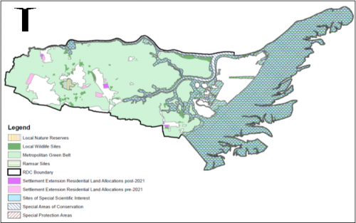
3.14 The predominantly rural nature of our district offers the potential to position us as the 'green part' of the South Essex. Large areas of public open space are located close to the towns of Rayleigh, Hockley and Rochford in the west, within the Upper Roach Valley, including Hockley Woods and Cherry Orchard Jubilee Country Park. Such open spaces provide accessible, quality recreational opportunities for our local communities. Our coast however is largely undeveloped, relatively inaccessible, and home to large areas of ecological importance, including Sites of Special Scientific Interest, Special Protection Areas, Ramsar Sites and Special Areas of Conservation. Foulness Island – which is the far eastern extent of our district – is owned by the Ministry of Defence with restricted and limited access. There are also smaller areas dispersed across our area, which are of local biodiversity importance, including Local Wildlife Sites and Local Nature Reserves. Figure 5 illustrates the extent of protected ecological areas across our district.
3.15 Due to our coastal nature, however, some areas of our district are identified by the Environment Agency as being at risk of river (fluvial) or sea (tidal) flooding. Approximately 7,071 hectares of our district have a 1% annual probability of fluvial flooding and/or a 0.5% annual probability of tidal flooding. Other areas of our district have been identified as being at risk from surface water, ground water and ordinary watercourse flooding; this is the responsibility of Essex County Council as the Lead Local Flood Authority. There are a number of critical drainage areas (CDAs) in our district, which are at risk of flooding and Essex County Council, with support from the Environment Agency, are implementing actions to minimise the risk.
3.16 A significant proportion of our area is important for its landscape and/or ecological value. The landscape character of our district is broadly made up of three types; Crouch and Roach Farmland; Dengie and Foulness Coastal; and South Essex Coastal Towns. The latter of these three is least sensitive to development, which is located towards the western extent of our district. Much of our area is flat and low lying, predominantly in the east, with more undulating gradients towards Rayleigh providing contrasting landscapes. The underlying geology has helped shape the varying landscapes across the district; which consists of one of the most substantial brickearth deposits within Essex. This resource is the most extensive and important in Essex, and although they remain unworked they require protection for the future.
Figure 5: Ecological Map of the District
3.17 The physical geography of our district gives rise to the potential to explore opportunities to promote tourism. The RSPB's Wallasea Island Wild Coast Project, adjacent to the realigned coast of Wallasea Island, represents a particular tourism opportunity – one which will have to be carefully managed given the area's ecological importance. Natural England are also spearheading the creation of the England Coast Path to develop a continuous path to improve public access.
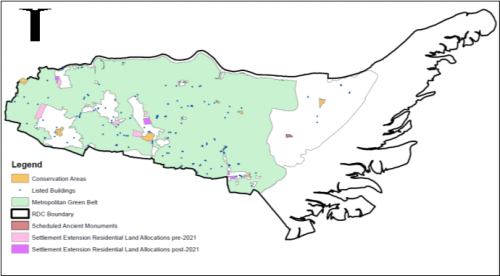
3.18 Our district is rich in historical and cultural heritage and is home to a number of historic assets including the historic towns of Rochford and Rayleigh. We have 10 designated Conservation Areas dispersed across our district, which are areas of high historic value. Careful attention must be given to ensuring that any changes continue to preserve and enhance the unique character of such areas, whilst allowing them to adapt to change. We are also home to nearly 400 Listed Buildings and five Scheduled Ancient Monuments, as well as a number of heritage assets which are not listed nationally but are considered to be of local historic importance. The distribution of historic assets across our district is shown in Figure 6.
Figure 6: Historic Map of the District
(7) Our Communities
Key Community Characteristics:
- We have an estimated 85,144 people living in our district, with 57% of our residents of working age
- The proportion of our residents over the age of 65 is projected to grow significantly in the future, which means we have an ageing population
- We have a high level of owner occupation in our area, however affordability is a significant issue which follows nationwide trend of unaffordability
- Compared to the rest of Essex we have the lowest crime rate, and health and wellbeing are generally considered to be very high in our district
3.19 In 2011, our district was home to 83,287 people; this is estimated to have increased to 85,144 people in 2015 according to the Office for National Statistics. Our district's residents are unevenly distributed, with the majority located in the western extent within the towns of Rayleigh, Hockley and Rochford. The location of facilities and services across our district broadly reflects this distribution. The largest settlement in the district is Rayleigh which, in 2011, was home to 32,150 people (39% of our residents at that time). Table 1 below provides a breakdown of the district's population by parish.
Table 1: Breakdown of population by Parish from the 2011 Census
|
Parish |
2011 Population |
Parish |
2011 Population |
|
Ashingdon |
3,634 |
Hullbridge |
6,527 |
|
Barling Magna |
1,740 |
Paglesham |
246 |
|
Canewdon |
1,473 |
Rawreth |
1,126 |
|
Foulness |
151 |
Rayleigh |
32,150 |
|
Great Wakering |
5,587 |
Rochford |
8,471 |
|
Hawkwell |
11,730 |
Stambridge |
700 |
|
Hockley |
9,616 |
Sutton |
136 |
|
District Total |
83,287 |
||
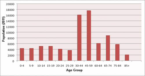
3.20 The proportion of residents aged 20 to 64 is expected to remain relatively stable over the next 20 years. However, our district has a higher proportion of older residents than the national and regional averages. The average age of residents in our district was 42.3 years in 2011, which is slightly higher than the average of 40.3 years recorded in 2001. Between 2014 and 2037 it is estimated that the number of residents over the age of 65 will increase by over 10,000, with a fairly even split between those aged 60/65 to 74, 75 to 84 and over 85. At present, approximately 57% of our residents are of working age, with 20% below the age of 19 and 23% above the age of 65. An increase in the older proportion of residents compared to the rest of the population has the potential to lead to a smaller workforce and higher dependency needs. A breakdown of the district's population by age group is shown in Figure 7 below.
Figure 7: Breakdown of Population by Age Group from 2011 Census
3.21 As a district we maintain a high proportion of owner occupied properties with 83% of households living in the owner occupied tenures, and compared to the rest of South Essex we have the lowest proportion of households, at 9%, living in the private rented tenure or living rent free. There were 34,444 households within our district in 2011, of which the predominant house type are detached and semi-detached dwellings, which comprise roughly 80% of total households. The majority of the remaining households consist of terraced dwellings, flats or maisonettes. The average value of a detached dwelling in June 2017 was £440,783 which is lower than the average price for the same property type in Essex (£644,446)[16].
3.22 Across South Essex there has been a long-term worsening in affordability, which is particularly pronounced in our district. This trend follows the national trend, and suggests that people working within South Essex would be required to spend a greater number of years' income on the cost of purchasing a home in the area where they work. As of July 2017 there are also 893 households on our Housing Waiting List – these are those residents most in need.
3.23 There are a number of schools and academies located within our district, including 22 infant, junior or primary schools and four secondary schools, all of which offer sixth form facilities. The combined numbers of students attending schools within the district was 12,302 in 2016, which is projected to slightly increase to 12,674 by 2021[17], taking account of new homes that are likely be delivered by this time. In addition, 86% of children attending schools in our district attend a 'good' or 'outstanding' school, which is higher than the 84.3% for Essex as a whole.
3.24 Standards of health and wellbeing are generally very high in our district, which is ranked 281 out of 326 local authorities on deprivation (where 1 is the highest level of deprivation). Overall, 69% of Rochford District residents rate their general health as good which is just below the county average of 70%[18].
3.25 We have the lowest crime rate in Essex, with a crime rate of 34.3 per 1,000 people in the year up to September 2015. The rate of motor vehicle accidents in our district is also lower than the county and national averages at 35 per 100,000 people. In general, the majority of our residents feel safe during the day, and feel safer at night than the county average[19].
[13] www.southeastlep.com/images/uploads/resources/TGSE_South_East_LEP_-_Growth_Deal_and_Strategic_Economic_Plan_WEB-7.pdf