Rayleigh Town Centre Area Action Plan - Issues and Options
02 The Issues
2.1 Introduction
(1) 2.1.1 This section of the report presents our understanding of the issues to be addressed within Rayleigh Town Centre. These have been informed by a combination of technical information and research prepared for the Local Development Framework, site visits and associated analysis, and consultation with stakeholders. The issues are presented by topic area and summarised towards the end of the chapter. The options that have been developed and presented later in the report respond to these challenges.
2.2 What you told us
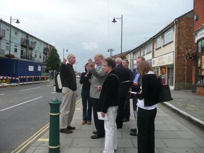
(1) 2.2.1 Consultation has formed an important part of the process and the views of stakeholders have been sought in identifying issues. This has been undertaken through a combination of meetings with Council Members, a letter drop and ‘Placecheck’ event with stakeholders (Figure 8).
(1) 2.2.2 Both the letter drop and ‘Placecheck’ event encompassed local residents on the Councils Citizens Panel and a cross-selection of locally interested stakeholder groups, including the District and Town Councils, Chamber of Trade, Federation of Small Businesses, Historical Society, National Trust and the Campaign to Protect Rural England (CPRE).
(1) 2.2.3 The Placecheck event was held to help inform ideas and options for future change and improvement in the town centre, ensuring that the views and opinions of local people help generate these options. Placecheck is a method of assessing the qualities of a place, showing what improvements are needed, and focussing people on working together to achieve them. Placecheck asks questions about the processes of change and the potential for improving the area physically.
(2) 2.2.4 The responses made through the consultation process highlight concerns around a number of aspects relating to:
- The appearance of the townscape;
- Mix of uses and activities;
- The quality of the pedestrian environment; and
- Traffic congestion and car parking.
(2) 2.2.5 Comments note that the Rayleigh has an attractive, historic town centre, but more could be done to improve this and, in particular, improving the quality of buildings that visually intrude on the intrinsic qualities of the High Street. Along the High Street, the former Tesco store, Police Station and adjacent development of retail units, flats and offices are considered to be the most unattractive buildings. A mix of façade improvements and/or redevelopment are suggested as ways forward. The quality of the Websters Way and Bellingham Lane frontages are also considered in need of improvement. These are particularly important given (a) the function of Websters Way as an arrival point into the town centre and (b) the setting of the Mount and the Mill. Linked with these comments is the recognised importance of local heritage and historic assets in the town centre.
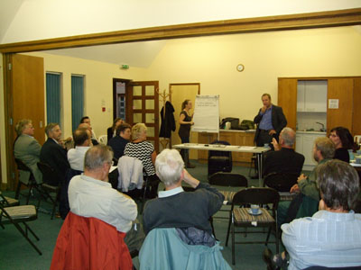
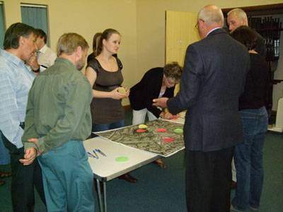
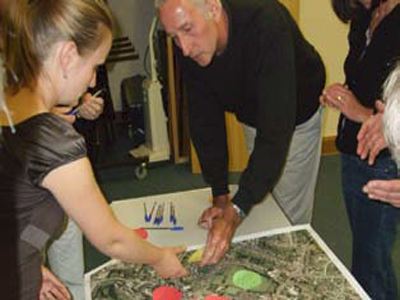 Figure 8: Images from the Rayleigh Town
Centre
Figure 8: Images from the Rayleigh Town
CentrePlacecheck Consultation Event
(5) 2.2.6 The comments also highlight the need for a greater diversity and mix of uses within the town centre. Specifically, comments indicate there are a limited range of shops, restaurants and cafes and few amenities for the younger population. Any new development should be flexible to allow for different use types: a particular concern was expressed about the number of vacancies in the town centre, particularly to the southern end of the High Street, and that efforts should be made to attract footfall and activity. Discussion during the Placecheck event included whether arts and cultural events could be held on the High Street, and whether this might be a location for a relocated and expanded market. It was considered that the taxi-rank in the High Street could be reduced in size or relocated altogether, improving the retail environment and potential for accommodating a street-based market.
(4) 2.2.7 During the Placecheck it became evident that consideration should be given to improving pedestrian connections in the town, particularly between Websters Way, High Street and the Mount. Direct, safe and well-signed routes should be considered. It was also suggested that the High Street could be part pedestrianised, though this would need to be considered in association with wider traffic implications.
(3) 2.2.8 Car-parking and traffic congestion were major concerns, particular the location and cost of parking, the volume and speed of traffic through the town. It was suggested that short-term parking should be free and that payment should be on exit, which would allow the town centre to compete with out-of-town retail stores providing free parking. Congestion along Websters Way and at key junctions around the town were also an area of concern.
(1) 2.3 Heritage and Conservation
(1) 2.3.1 A thorough understanding of the historic context of Rayleigh is important to ensure that any options developed respond appropriately to this context, protecting and enhancing local distinctiveness. This understanding is particularly critical because Rayeigh heritage plays a large part in its attractive and distinctive character.
(5) 2.3.2 There are a number of documents that describe Rayleigh’s heritage including the Rayleigh Conservation Area Appraisal (2007), Listed Buildings in the Rochford District (2005), the Heritage Conservation Record of Rayleigh Castle and the Rayleigh Historic Town Assessment Report (1999).
(3) 2.3.3 Rayleigh is an attractive market town with a strong heritage and a number of attractive listed buildings. It is located on the crest of a north south ridge, a prominent feature in low-lying south west Essex. The Domesday Book demonstrates that there was a village at Rayleigh at the end of the Saxon period (410 – 1066). Swein of Essex built his castle there at some point between 1066 and 1086 and there is still a substantial Motte and Bailey on the site (now ‘Rayleigh Mount’). It appears that the town remained as a small market town with a stable population until the beginning of the 20th Century when the introduction of a railway led to its growth as a commuter town (Rayleigh Historic Town Assessment Report, 1999). The Rayleigh Historic Town Assessment Report outlines some of the archaeological findings from the town and states that there may be archaeological evidence still extant.
(3) 2.3.4 The Rayleigh Conservation Area (designated in 1969 and extended in 2009 - see Figure 9) covers the historic centre of the village and also takes in Rayleigh Mount (the site of the Swein of Essex’ castle), a scheduled ancient monument, on a spur to the north west of the High Street. The conservation area was designated partly in response to rapid development taking place in the High Street. The Rayleigh Conservation Area identifies some of the key features in Rayleigh, including:
24 listed buildings in the historic town area of Rayleigh,
all of which are grade II listed except Holy Trinity Church
which is Grade II *.
The most notable of the listed buildings are the Holy Trinity
Church, the Windmill (19th Century), Kingsleigh House (18th
Century red brick building on the High Street which has been
converted into offices) and Francis House (now Lloyds Bank on
the High Street)
The original structure and framework of the town remain
legible today.
Rayleigh has an exceptionally wide High Street (a feature of
the medieval period), presided over at one end by Holy
Trinity church Rayleigh Mount, the site of a Norman castle,
given to the National Trust in 1923 and designated a
scheduled ancient monument.
Rayleigh Mount is a site of national importance because it is
one of the very few castles mentioned in the Domesday Book,
and one of the oldest recorded castles in England. Abandoned
as a castle in the 14th Century, it was used as a Royal Stud
and then a farmyard. It is now a key area of open space in
the area and is well used for recreational purposes.
A High Street which consists largely of 20th Century
buildings but also has buildings from the late medieval times
(which represent an important archaeological resource), 16th,
17th and 18th centuries and still retains the sense of an
historic town.
Attractive views looking up and down the High Street (in
contrast to the unattractive ones looking up and down
Websters Way).
Attractive views over the surrounding countryside from the
top of London Hill.
(5) 2.3.5 I t is these features which have contributed to the conservation area designation and which contribute to Rayleigh’s distinctiveness and character. The Conservation Area Appraisal (2007) also sets out a number of management proposals which will need to be considered when making proposals for the masterplan. These include:
- The protection of Brooklands Gardens and King George’s Field;
- Better management of the trees and boundaries of the Mount;
- Highlight the attention that needs to be paid to the backland space in particular at Websters Way and Bellingham Lane;
- The need to deal with issue of car parking (suggests a multi storey car park but questions whether it is viable);
- Suggests more rigorous implementation of shopfront and advertisment control;
- Justifies the extension of the conservation area boundaries, most notable extending it to the east side of Websters Way and possibly even to include the car park and King George’s Field to the east; and
- Justifies the use of an Article 4 (2) direction in the conservation area to further control development such as application of render, alterations to windows.
(1) 2.3.6 In order to ensure that masterplan proposals are deliverable and fit within the wider policy direction of the Council it is important to consider the policies that concern conservation of heritage that are currently part of the planning policy framework. There are a number of policies within the Rochford District Replacement Local Plan June 2006 (which have now been saved until the core strategy is adopted) that seek to preserve and enhance the conservation areas.
(2) 2.3.7 This policy is supplemented by the Conservation Area SPD (January 2007) regarding scale, form, materials, siting and also covering more specific topics such as design for roofs, chimneys, walls etc. The SPD notes however that:
"The advice contained in this Supplementary Planning Document (SPD) is not intended to be prescriptive. There is little value in modern architecture simply reproducing all the building styles that have gone before."
(1) 2.3.8 Of particular importance for this study is Policy BC2 which covers demolition in a conservation area. This policy states that:
“Consent for the demolition of a building in a conservation area will only be granted in cases where all of the following criteria are met:
-
- the building to be demolished is of no architectural or historical interest and makes no positive contribution to the character or appearance of the conservation area;
- sufficient evidence has been provided to demonstrate that the building is beyond reasonable repair, having regard to its structural condition, the cost of repairing and maintaining it in relation to its importance, and to the value derived from its continued use; and that every effort has been made to find compatible alternative uses for the building and to sell it on the open market at a price reflecting its structural condition
-
- detailed plans for the after-use of the site have been submitted to, and approved by, the Local Planning Authority. (In cases where the after-use of the site includes development requiring planning permission, such permission must have been applied for and granted in order that the terms of this criterion be met); and
- The local planning authority will require the signing of a legal agreement before permission for demolition is granted, requiring the redevelopment of the site within an agreed timeframe.“
(1) 2.3.9 The reason for highlighting the detail of policy BC2 is that careful regard will need to be had to this policy should any demolition in the conservation area be proposed as a part of the masterplan. There is also a potential conflict here with regard to the desirability of redeveloping unattractive buildings in the town centre to enhance the quality of the conservation area. This is discussed within the section on planning policy below (see section 2.5)
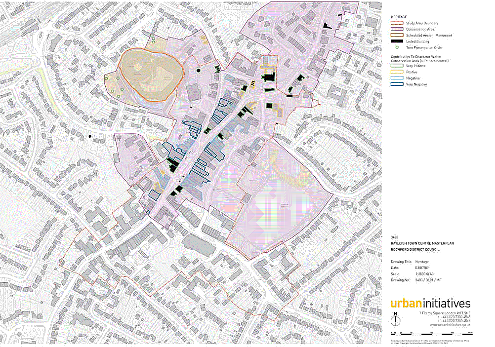 Figure 9: Town Centre Heritage Aspects
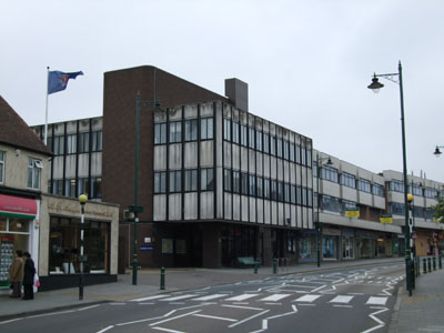 Figure 10: Police Station and adjacent
buildings on the High Street
Figure 10: Police Station and adjacent
buildings on the High Street
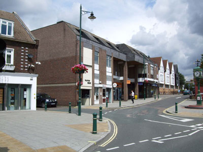 Figure 11: Buildings along Bellingham
Lane
Figure 11: Buildings along Bellingham
Lane
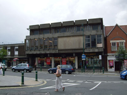 Figure 12: Former Tesco store on the
High Street
Figure 12: Former Tesco store on the
High Street
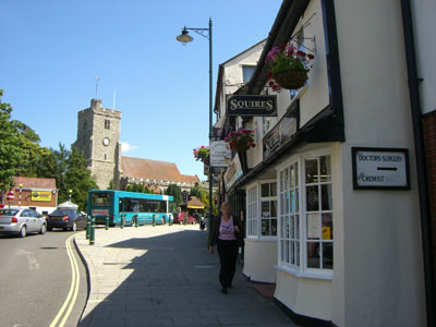 Figure 13: Looking north along the
High Street to
Figure 13: Looking north along the
High Street toHoly Trinity Church
(1) 2.3.10 Policy SAT 8 provides guidelines on shop fronts (for example that they should be designed to complement the style and proportions of the affected building, and to those adjoining it) and Policy SAT 10 provides guidance on advertisements in conservation areas (for example that the use of internally illuminated fascias and projecting box signs will not be permitted).
(2) 2.3.11 The implications of this is that the historic value of Rayleigh means that the options developed will need to be very sensitive to the context of the area and seek to preserve and enhance the characteristics and special buildings discussed above. Options will also need to have regard to the planning policy that guides development in Rayleigh, in particular in the conservation area.
(1) 2.3.12 However, the fact that Rayleigh has a large number of important historic features and a conservation area that is controlled by a range of planning policies does not mean that development (including development using modern architectural design) should not take place. As is set out in the Conservation Area SPD guidelines:
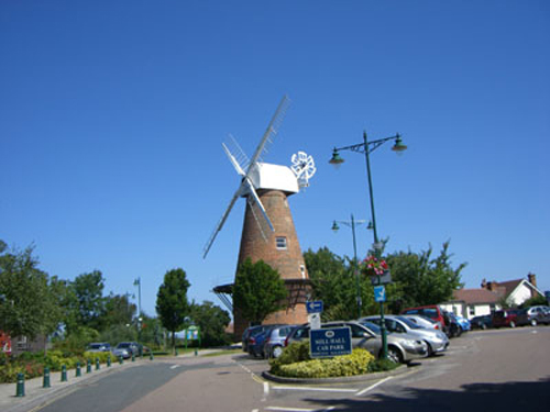 Figure 14: Rayleigh Windmill
"conservation areas are not museums; they need to change and evolve over time just as they have always done. Carefully designed new buildings can make a positive contribution to character and there are situations where the sensitive redevelopment of an eyesore can enhance the quality of an area."
(1) 2.3.13 The Conservation Area Appraisal (2007) reiterates the point that redevelopment of certain buildings in the backlands and even the High Street may be appropriate and could be carried out to the benefit of the town centre.
 Figure 15: Historic buildings on the
High Street
Figure 15: Historic buildings on the
High Street
 Figure 16: More recent development on
the High Street
Figure 16: More recent development on
the High Street
(1) 2.4 Form and Structure
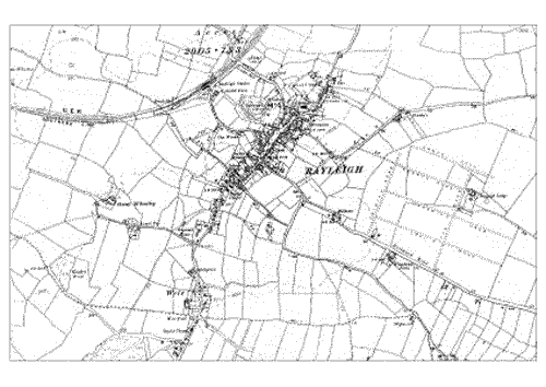 Figure 17: Historic map of Rayleigh,
dated 1896
Figure 17: Historic map of Rayleigh,
dated 1896(source: Rochford District Council)
(2) 2.4.1 Rayleigh has broadly retained its historic urban structure (Figures 17-19). The ‘Y-shaped’ High Street remains intact and the open space and topography formed by the Rayleigh Mount is also still in existence. The main divergence from the historic pattern comes with Websters Way, which forms a newer route running parallel to the High Street.
(1) 2.4.2 As with the form of the town, the urban grain remains largely intact along the High Street. Whilst the aesthetic value of some of the infill development can be questioned, in the main it retains the fine grain pattern of the High Street, exceptions including the Police Station. It is one of the attractive and distinctive traits of Rayleigh that the historic form of development is still apparent, making it representative of a traditional Essex market town.
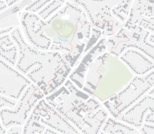 Figure 18: Plan of Rayleigh today
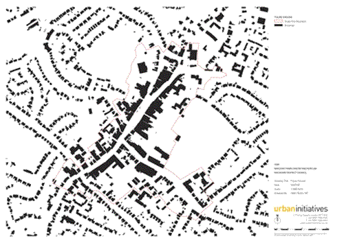 Figure 19: Plan of Rayleigh today
(Figure Ground Plan)
Figure 19: Plan of Rayleigh today
(Figure Ground Plan)
(1) 2.4.3 The main focus of Rayleigh town centre today is still the High Street, between Eastwood Road and London Hill. Running south west to north east through Rayleigh, the High Street is dominated by retail uses with some residential properties above the shops. Further peripheral retail can be found to the south western end of the High Street and the Holy Trinity church and an outdoor market are positioned at the north eastern end (Figure 22).
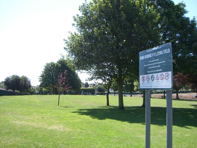 Figure 20: King Georges Field
(1) 2.4.4 To the south east of the High Street, retail gives way to an area dominated by Websters Way car park (a well-maintained surface car park) and accesses for servicing. Servicing to the shops along the High Street mainly takes place along Websters Way and the frontage along this road is unattractive, formed as it is by the backs of shops, which do not form an even building line with the street. For vehicles coming from the north, Websters Way forms a poor first impression of Rayleigh town centre (Figure 21).
(1) 2.4.5 The town centre is bounded to the south east and the north west by areas of open space. To the south east (forming a boundary with Websters Way car park) lies King Georges Field, a large area of public open space (Figure 20). Forming the north western boundary to the town centre is Rayleigh Mount. Owned by the National Trust, this is a large, attractive and well maintained area of public open space. As the name implies, the area is on a hill with paths round the wooded slopes of the hill which lead into open areas affording excellent views onto surrounding countryside.
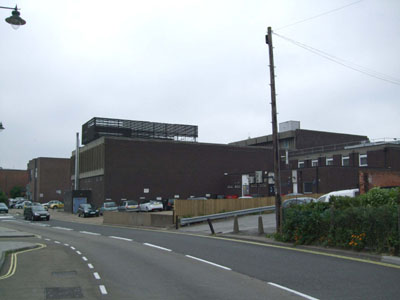 Figure 21: Websters Way
(1) 2.4.6 There are good links from South West to North East through the town along the High Street. However, the links are weaker between the high street and Websters Way to the east and Rayleigh Mount to the west with a lack of ways through off the High Street into the surrounding areas.
(1) 2.4.7 The building heights in Rayleigh town centre mainly range between two and three storeys, with the higher buildings usually associated with more modern infill development (Figure 23). There are a scattering of four and five storey buildings including Holy Trinity Church Spire and Rayleigh Windmill. These are important landmarks for the town and the church in particular enhances the legibility of the town, positioned as it is on top of a hill at the end of the High Street.
(2) 2.4.8 Outside of the study area, the buildings are predominantly residential and are mainly between one and two storeys, built at a relatively low density.
 Figure 22: Broad structuring plan
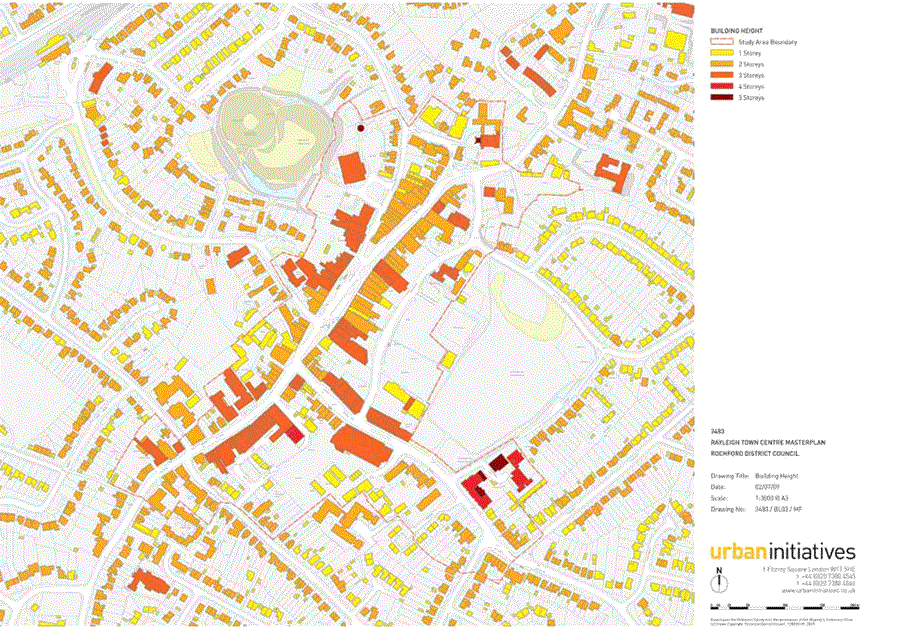 Figure 23: Town centre building heights
(1) 2.5 Policy Context
NATIONAL LEVEL
(1) 2.5.1 At the national level, Government planning policy for town centres is set out in Planning Policy Statement (PPS) 6 (Planning for Town Centres, march 2005). This is currently subject to review. A consultation draft of the proposed changes was published in July 2008, although this has since been superceded by consultation on revised PPS 4 (Planning for Prosperous Economies) published in May 2009 and which incorporates policies for town centres. Although the adopted version of PPS 6 remains Government policy, the consultation documents represent the current direction of thinking and must be given due weight in developing plans and proposals.
2.5.2 Emphasis is given to safeguarding and protecting investment in town centres, recognising the important role that attractive town centres play at the heart of community life. However, it is recognised that in the current economic climate planning policies need to be flexible and responsive to change, particularly to support the start-up and growth of businesses, attracting inward investment and increasing employment.
2.5.3 In addition to this, the Government has also published a document entitled ‘Looking after our town centres ’ (April 2009). This provides guidance on how the potential of town centres can be realised during the economic downturn in order to maintain vibrancy, identity and sense of place. In particular, the guide highlights the importance of attractive and safe town centres, variety, diversity and the positive use of planning and licensing powers.
REGIONAL AND SUB-REGIONAL LEVEL
2.5.4 The Regional Spatial Strategy for the East of England (RSS 14: East of England Plan) was published in May 2008 The strategy seeks to bring about sustainable development, supporting urban and rural renaissance, new housing, employment and other facilities, and improved transport accessibility. Outside of the regions main areas of change (i.e.: its larger towns and cities), the role and importance of smaller market towns is recognised: thriving, vibrant and attractive centres are central to the overall approach to sustainable development and should be at the focus of investment, environmental enhancement and regeneration.
(2) 2.5.5 The regional spatial strategy sets minimum growth targets for each district. For Rochford, it is expected that 4,600 new dwellings be provided in the district over the period 2001 – 2021. Similarly, provision for job growth is required. In this instance though Rochford is grouped with Thames Gateway sub-region. 55,000 new jobs are expected to be provided across the region over the period 2001 – 2021, most of which will though be in Thurrock, Basildon, Southend and Castle Point.
(4) 2.5.6 Although the district falls outside of the Thames Gateway Growth Area the implications of this can not be ignored, particularly in terms of accessibility and the growth of competing centres. It is thus important that local character and distinctiveness is central to any future change or regeneration within Rayleigh. Indeed, RSS 14 notes that plans and policies should ensure that historic environments are protected, enhanced and conserved as appropriate. In particular, Policy EN V7 (Quality in the Built Environment) states that:
"Local Development Documents should require new development to be of high quality which complements the distinctive character and best qualities of the local area and promotes urban renaissance and regeneration".
DISTRICT LEVEL
2.5.7 At the district level, the Sustainable Community Strategy 2009-2021 (Rochford Local Strategic Partnership, April 2009) is seeking to achieve a better quality of life for everyone in the borough. The strategy identifies seven priority areas for consideration and action:
- Supporting the ageing population;
- Fostering greater community cohesion;
- Strengthening the Third Sector1;
- Increasing accessibility to services;
- Keeping Rochford safe;
- Encouraging economic development; and
- Promoting a greener district.
2.5.8 These priority areas are embedded within the Councils emerging Core Strategy, which is currently at submission stage (September 2009). In terms of Rayleigh Town Centre, the Core Strategy notes that it is the principal centre in the district and that an Area Action Plan will be prepared (see policy RTC4, as referenced in the introduction to this issues and options report). People will be encouraged to use the centre by ensuring that it is attractive, accessible and contains a variety of uses.
2.5.9 The Core Strategy also states that permissions for non-retail uses will be restricted to maintain and the long-term viability and vitality of the town centre, ‘avoiding long stretches of dead non-retail frontage’. Some non-retail uses will be allowed, though the amount will be controlled, focussing retail uses within core areas and non-retail uses within secondary shopping frontages (see paras 12.15 and 12.16).
2.5.10 However, the Retail and Leisure Study (Rochford District Council, August 2008) undertaken to inform the production of the Core Strategy recommends that the town centre would benefit from a greater range of leisure service providers and that the Council should adopt a supportive approach to further comparison goods (generally relating to non-food items which are likely to be subject to comparison between suppliers before they are purchased) floorspace within the town centre. The study also notes that there are few vacancies in the centre, that it has a good range of retail service, financial and business service providers, and that it’s mix of unit sizes make it attractive to a wide variety of retailers.
(1) 2.5.11 One of the important parts of this AAP will be to consider the role and function of Rayleigh Town Centre in relation to other town centres. Whilst Rayleigh is the principal town centre in the district, there are a number of competing centres in the wider region, such as Southend, Basildon and Chelmsford. In order to retain vitality and viability in the face of these larger centres, Rayleigh will need to build on its key strengths – the cultural attractions of Rayleigh Mount and Windmill, the High Street with its good range of shops and community facilities (for example Holy Trinity Church and associated community centre) and the attractiveness of its built form.
(3) 2.5.12 The Employment Land Study (Rochford District Council, October 2008) recommends that the Council investigate the possibility of allocating employment land in Rayleigh Town Centre for office use in the form of a mixed-use scheme. Whilst both the employment and retail studies were undertaken during different economic circumstances to those being experienced at the time of writing, they do look forward over a long timeframe. Even though the recommendations may not stand at the current time, they do need to be considered, with the Issues and Options report putting in place the framework for opportunities for change once the economy does pick-up.
(2) 2.5.13 Policy also states that a positive approach will be taken to residential uses in the centre, particularly in terms of conversions above retail uses, enhancing the vibrancy of centres and reducing the amount of green belt land take.
2.5.14 This suggests that a mix of uses within the town centre will be encouraged, ensuring activity an vibrancy, but that the primary role of the town as a retail centre should be strengthened.
2.6 Development Pipeline
(2) 2.6.1 Within the town centre two applications have been granted permission. These are adjacent to each other:
- Permission has recently been granted (July 2009) for the redevelopment of the Rayleigh Lanes building between the High Street and Websters Way (Figure 24). The proposed scheme seeks to retain the ground floor retail uses and access points to this on both the High Street and Websters Way. However, the proposals seek to redevelop the upper floors, replacing the current snooker hall use with two floors of residential units. A total of twelve units are included within the scheme proposals, comprising a mix of one and two bed flats. These would be accessed via Websters Way. The scheme includes a blank façade along its southern edge, allowing for the redevelopment of the adjacent site.
- Next to Rayleigh Lanes (on land to the rear of 91 High Street - Figure 25), permission was granted in September 2006 for a new four-storey building accommodating fifteen two-bed flats and eighteen car parking spaces. Work has yet to commence on the scheme and permission is due to expire in September 2009. This may allow scope for elements of the scheme to be re-considered, including the relationship between the proposed buildings and the pedestrian route alongside this, linking Websters Way to the High Street. Development should help to formalise this route and make it a safer, more attractive link for pedestrians, with active ground floor uses, landscaping and lighting.
(2) 2.6.2 The options presented in section 4 of this report show either redevelopment or façade improvements to the Rayleigh Lanes site. Development of the adjacent site is considered in higher-change and improvement options presented in section 4. The principal of development on this site is accepted, but should the permission expire it may be possible to review the form and nature of the development.
 Figure 24: Rayleigh Lanes as existing
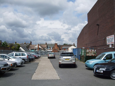 Figure 25: Site adjacent to Rayleigh
Lanes
Figure 25: Site adjacent to Rayleigh
Lanes
(6) 2.7 Transport and Movement
Street Network
2.7.1 Historically, as illustrated in Figure 17, the town grew up around the High Street and the Mount. As with most medieval settlements, streets were designed with the horse and cart in mind and vehicular traffic has put pressure on the historic road system.
2.7.2 Up until the implementation of a Department for Transport pilot project scheme some ten years ago, a gyratory system was in place around the town centre. Two eastbound lanes of traffic ran along the High Street and two westbound lanes along Websters Way (Figure 27).
(1) 2.7.3 As a result of the pilot project, the High Street remains one way only east bound, although Websters Way has reverted to two way operation. This has removed some traffic from the High Street and helped contribute to an enhanced retail environment as eastbound traffic is now able to use both the High Street and Websters Way.
(1) 2.7.4 It has though reduced road capacity for westbound traffic, which is limited to one lane only along Websters Way. Coupled with the presence of the main town centre car park and retail servicing arrangements along this route, Websters Way now experiences congestion. This is the main arrival point into the town for vehicles but conditions along Websters Way are decidedly poor, with the backs of retail premises forming the northern edge of the street and surface parking forming a large portion of the southern street edge.
2.7.5 The western part of the High Street is two way and provides a critical link from the town to the Southend Arterial Road (A127), a largely grade separated dual carriageway running from Southend-on- Sea all the way through to the M25.
2.7.6 Crown Hill connects the High Street with Rayleigh Railway Station and, after it becomes Station Road, is the main link across the railway line to residential areas to the north and onwards to Hullbridge. London Hill provides an alternative local route for traffic moving from the High Street to Station Road. Eastwood Road, to the south west of the study area, is a local route running parallel to the Southend Arterial.
(2) 2.7.7 Road junctions in the town centre primarily take the form of roundabouts (Figure 26). Mini roundabouts are in place to the east at the junctions of the High Street with Crown Hill and Eastwood Road, and the Websters Way and Eastwood Road junction. A partially signalised junction is in place at the Church Street, High Street, Bull Lane (Websters Way) and Hockley Road junction, of which there are currently proposals for improvement in the form of full signalisation and the introduction of an additional right turn lane from the High Street into Websters Way, relieving congestion at a localised pinch point.
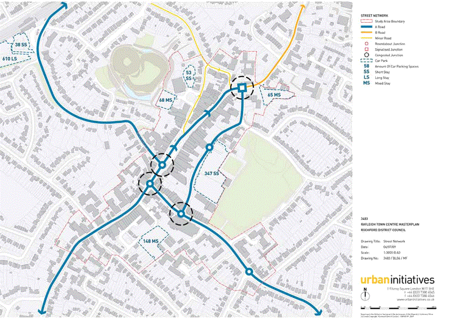 Figure 26: Rayleigh town centre street network and car
parking provision
Figure 26: Rayleigh town centre street network and car
parking provision
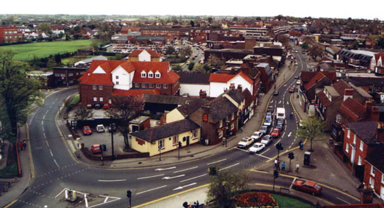 Figure 27: The former highways
arrangement created a
Figure 27: The former highways
arrangement created aone-way gyratory around the town centre
(image source: Wikipedia)
Parking
(1) 2.7.8 A range of short and long term parking is provided in and near to the town centre (Figure 26). The railway station has approximately 610 long-stay parking spaces spread over two connected car parking areas, and a 38 space short-stay car park adjacent to the station building.
(1) 2.7.9 There are a number of short (less than four hours) and mixed-stay car parks spread around the town core, of which the most substantial and anecdotally well used is the Websters Way car park with 347 spaces. Another 53 space short-stay car park is located adjacent the Windmill and The Mill Arts and Events Centre, with a further mixed-stay car park located to the west with 68 spaces.
(2) 2.7.10 Behind the Somerfield store there is a 148 space mixed-stay car park. To the east of the town adjacent to the Council Civic Suite is a 65 space mixed-stay car park that is also used as a market. In March 2003 the market licence was extended for a further seven years. The licence will therefore expire in March 2010. This represents an opportunity to review its location and operation.
2.7.11 An origin and destination survey undertaken for users of the Websters Way car park by Mouchel Ltd, identified that the majority of people using this car park were accessing the town centre for personal business and shopping reasons.
(2) 2.7.12 This survey, supported by observations on site, alludes to the fact that town centre car parking is critical in supporting the local economy and wholesale removal of parking spaces would not be advisable. That being said, some rationalisation of car parking may be considered appropriate on the basis of managing travel demand, and justified on the grounds of replacing car borne trips to the centre with new walking trips generated from new development in close proximity.
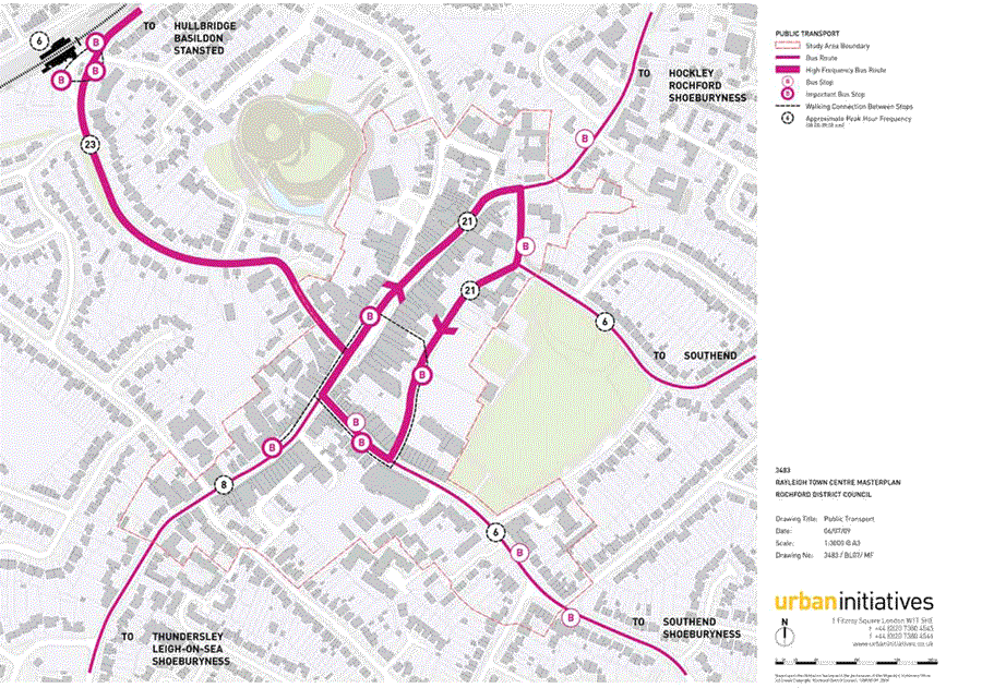 Figure 28: Rayleigh town centre street public transport
provision
Figure 28: Rayleigh town centre street public transport
provision
Public Transport
(2) 2.7.13 An extensive bus network operates in Rayleigh with the wider sub-regional service structure gravitating to Southend-on-Sea (Figure 28). Bus routes with one or more services per hour connect Rayleigh with Hockley and Rochford to the east (services 7, and 8), with Southend and Shoeburyness to the south (services 1, 9, 20, 24, 25), with Basildon to the west (service 25) and with Hullbridge to the north (20). The X30 also runs through the town providing an hourly express bus service from Southend through to Stansted Airport.
2.7.14 Numerous bus routes begin and terminate at Rayleigh Railway Station (services 1, 7, 8, 9, 24) making this an important rail bus interchange point for the town. Rayleigh is on the London Liverpool Street railway line. The line offers a ten minute service in the peak hour and a twenty minute service in the off-peak with an approximate journey time to London Liverpool Street of between 41 and 44 minutes.
2.7.15 Buses heading towards Southend and Shoeburyness typically move in a clockwise direction around the town core via High Street, Websters Way and Eastwood Road. Services branch off this route at Hockley Road, Bull Lane, Eastwood Road or the western part of the High Street. Total flows on this one-way route are approximately 21 buses per hour on an average 0800 – 0900 am peak period, or a bus every two minutes.
2.7.16 Buses travelling north through Rayleigh typically stop on Websters Way, Eastwood Road and the High Street, dependent on the approach road, but do not travel through the town core proper. This means that in addition to the rail-bus interchange, there are four key stops in the town core that provide access to all bus services passing through Rayleigh.
2.7.17 Efforts should aim to improve the operation of the bus rail interchange, and the four town core stops, the quality of the waiting environments and the walking connections between them. Bus information and signage should also be used to improve the interchange between bus routes.
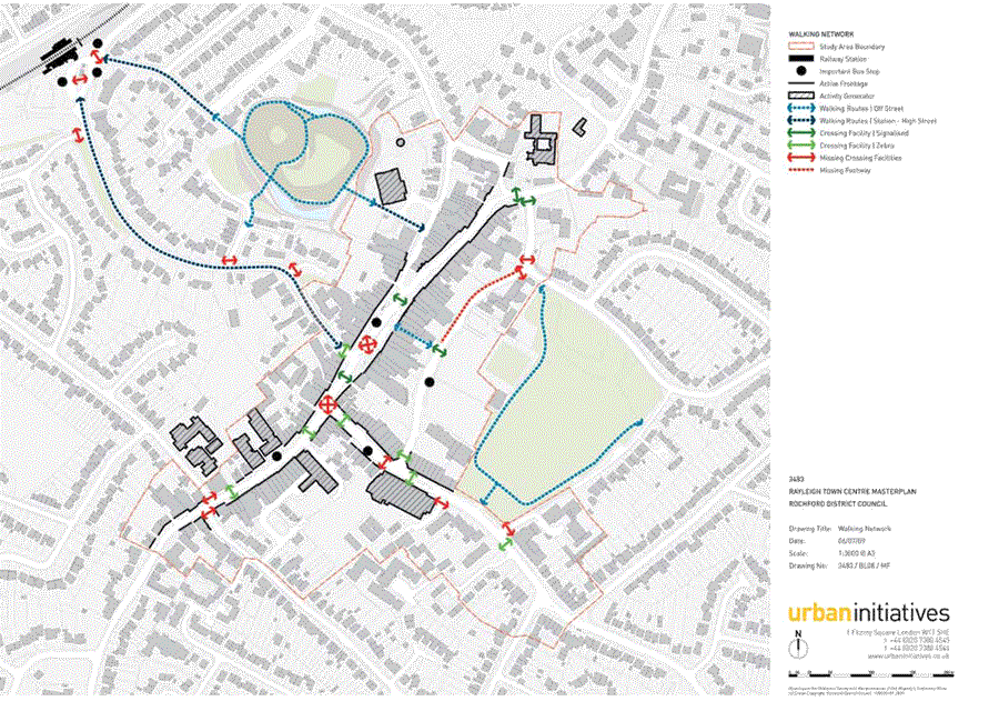 Figure 29: Rayleigh town centre pedestrian movement network
Walking and Cycling
(1) 2.7.18 Walking is provided for generally by way of the publicly accessible street network. The main walking route from the station to the town core is via Crown Hill (Figure 29). This is an uphill walk with, in some instances, very narrow footways and high volumes of traffic. A further, though at present inconspicuous route, is via Castle Drive and through Rayleigh Mount to Bellingham Lane. Although relatively direct, unmade surfaces and secluded areas do not encourage pedestrian use.
2.7.19 Although there are a variety of formal walking facilities provided across the town, the presence of guardrailing and bollards result in pedestrians being diverted away from what would be a direct crossing point. That is, rather than being able to walk directly between areas of attraction, people have to deviate around and along junctions. This impacts on most junctions around the town but also along the High Street itself. In particular, the High Street bus stop, stand and taxi rank dominate and require pedestrians to modify their routes accordingly. Websters Way also has a significant section without a footway that needs to be resolved.
(1) 2.7.20 There is no information on current signed or advisory cycle routes in the town and no national cycle routes pass through Rayleigh. There are also no on road facilities to speak of. Patches of cycle stands are provided on the High Street.
(1) 2.7.21 The walking connections between the station and the High Street need to be reviewed in detail and improvements identified and prioritised. For the High Street, building upon the success of the existing streetscape, minor walking improvements could be delivered in the form of redesign of the taxi rank (known locally as ‘Boots Lagoon’), the removal of pedestrian guard railing and general decluttering.
(3) 2.7.22 A focus for walking improvements in the town should be at the roundabouts so that direct pedestrian crossing points are appropriately provided. This will require consideration of interventions to slow traffic approach speed and to speeds through the junction itself. This may involve moving crossings closer to the junction, tightening kerb radii, raising the carriageway the use of vertical elements like trees or lighting, and the treatment of the roundabout island.
(1) 2.7.23 The approach to cycling in the town will be to manage traffic speeds and focus on the provision of appropriately located cycle racks at the station and High Street.
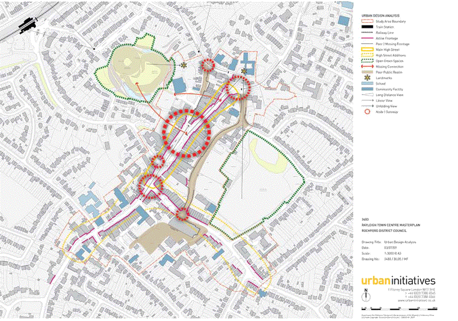 Figure 30: Rayleigh town centre urban design analysis plan
(2) 2.8 Summary of Issues
(6) 2.8.1 We summarise a range of issues below, which are illustrated in Figures 30-34 and which include:
1 Quality and appearance of the town centre: Much of the town centre includes high-quality, attractive historic buildings. However, the quality of relatively recent development in and around the High Street (i.e.: from the 1960s onwards) serves to undermine the quality and setting of the conservation area and the towns many listed buildings. The Conservation Area Appraisal (2007) rates many of these as being negative or very negative. Policy BC2b of the Conservation Area SPD 2007 (see section 2.3 above) however requires full consideration to be given to alternative uses and potential of the building prior to redevelopment. There also a number of buildings outside the conservation area which undermine the quality of the town, including the Somerfield store on Eastwood Road and the Police Station and neighbouring shops / flats to the west end of the High Street. The scale and flexibility of these buildings for alternative uses in the future may be limited. The High Street taxi-rank is also relatively large for the size of the town and is visually intrusive.
2 Range and mix of uses: Although the town centre is relatively buoyant with few vacancies the LDF evidence base notes that the town centre would benefit from a greater range of leisure service providers, adoption of a supportive approach to further comparison goods floorspace and the promotion of mixed-use schemes incorporating office floorspace. Where there are vacancies, these tend to be located in clusters, with the highest concentration alongside the Police Station. The Core Strategy however seeks to restrict the introduction of restaurant and café type uses within the primary retail areas (see paras 12.15 - 12.16 of the Core Strategy). The current Market, located off Hockley Road, is off-centre. Its operation is considered important to the mix and offer within the town centre but its license is due to expire in March 2010.
3 Connections between the High Street, Mount and Mill: Rayleigh Mount, the Windmill and Mill Arts and Leisure Centre represent an important and locally unique cluster of leisure and cultural activities. The Mount, in particular, as a National Trust site, is a major asset for the town. This cluster of uses is however poorly connected with the High Street: although distances between the two are short, the relationship between the two is poorly defined. This is also undermined by the quality of the interface between buildings and the public realm on Bellingham Lane.
4 Function, quality and appearance of Websters Way: In terms of the overall highway network for the town, one way working on the High Street means that Websters Way functions as an important traffic corridor around the town core. This is also the main servicing and car park access route for the town. It is an unwelcoming arrival point into the town centre and suffers from traffic congestion. In particular, the quality of Websters Way contrasts with the High Street, its form and appearance does little for the attractiveness and vitality of the town. It is very traffic dominated, in places lacks any footway and is generally unconducive to walking. Connections between the main town centre parking facility and the High Street are limited.
5 Pedestrian movement and public realm: The pedestrian is relatively well catered for along much of the High Street: pavements are generous in places and seats are provided. However, in some locations, the presence of guardrailing and bollards hinder pedestrian movement. On-street and, in some places, on-kerb parking conflict with pedestrians, particularly towards the top of the High Street. The taxi rank is also visually intrusive and occupies a large area of space on the High Street, reducing pedestrian and shopper amenity.
6 Traffic movement and congestion: Although the one-way system does not appear to unduly impact on the quality of the High Street environment it does result in traffic queues at several locations, including the junction of Church Street, the High Street and Bull Lane (Websters Way). Here, the proliferation of street signs and signals required to control traffic results in street clutter that undermines the setting of Holy Trinity Church and surrounding historic environment. There is also evidence of queuing into the Websters Way car park and at the junctions of the High Street with Crown Hill and Eastwood Road. Footpaths also narrow at some of these points, limiting the quality of the retail environment.
QUESTION 1:
(15) Do you agree with the issues identified?
(11) Are there any other issues that we should be considering?
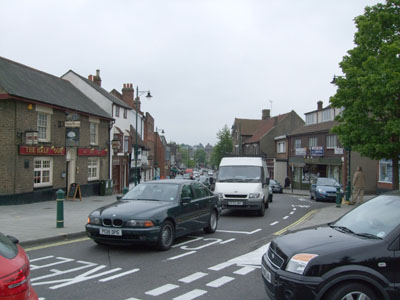 Figure 31: Traffic congestion at the
High / Church Street junction
Figure 31: Traffic congestion at the
High / Church Street junction
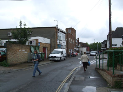 Figure 32: Exposed servicing areas on
Websters Way
Figure 32: Exposed servicing areas on
Websters Way
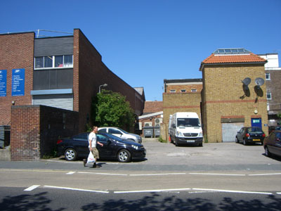 Figure 33: Rear of High Street
properties on Bellingham Lane
Figure 33: Rear of High Street
properties on Bellingham Lane
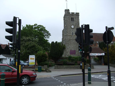 Figure 34: Street signs and signals
outside Holy Trinity Church
Figure 34: Street signs and signals
outside Holy Trinity Church
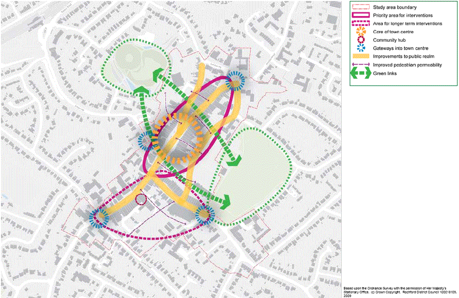 Figure 35: Rayleigh Town Centre Concept Plan
1 T he Third Sector includes voluntary and community organisations, charities, social enterprises, cooperations and mutuals