Rochford Area Action Plan Submission
(2) 2. Rochford in context
This chapter sets out the planning and policy context within which the Rochford AAP will operate, including a review of key sections of the local planning evidence base.
2.1 Strategic location and local setting
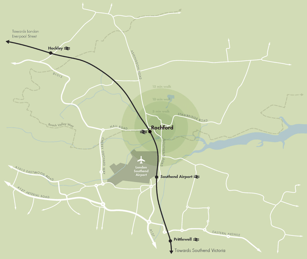
Rochford is located approximately 1 mile north of Southend-on-Sea, on a peninsula bounded by the River Thames to the south, the River Crouch to the north and the North Sea to the east. The River Roach, a tributary of the Crouch, runs through Rochford and dominates the character of the landscape to its east.
Although the town is adjoined by residential development in the parishes of Ashingdon and Hawkwell to the north, it is mostly surrounded by Green Belt and retains the feel of a small market town, despite its proximity to more built up areas in the south. Within the District, Hockley and Rayleigh are located to the west of Rochford.
Rochford is located on the Great Eastern rail connection between Southend-on- Sea and London Liverpool Street, which supports commuting into central London, approximately 30 miles away. The A127, A13 and A130 roads, which meet to the west of Rayleigh, can be accessed via the B1013. Local attractors for car journeys are Southend-on-Sea to the south east, Basildon to the west and Chelmsford to the north-west.
London Southend Airport, which has domestic and international routes, is located to the immediate south west of the town. The proximity of the airport has an impact on both accessibility and amenity.
2.2 Historical evolution and Conservation Area
Much of Rochford’s past can be read through its well preserved form, layout and buildings. Indeed, rather than having a high street, Rochford has an axial street pattern, comprising North, East, South and West Streets, with a central Market Square. This reflects its origins as a settlement that grew up around the market established in 1257, within the landholdings of Swein of Essex.
Rochford grew slowly and is understood to have had a population of around 1,000 at the turn of the 18th Century. During the 18th and 19th Centuries the town prospered, being the principal town in the area prior to the rise of Southend and, unlike Rayleigh, having direct access to the coast. A range of trades and industries took place within the town and gave it a stable economic base.
Although the coming of the railway from London Liverpool Street in 1889 did not lead to a rapid increase in the size of the town – as it did in some other locations – there was significant growth both before and after the Second World War, with residential development to the north. The major expansion of Rochford Hospital, principally in the 1930s and 1940s, has also had an important impact on the townscape, with the campus-style development interrupting Rochford’s typical fine-grain urban form.
Rochford Conservation Area was first designated in 1969 and originally only covered the historic town centre. It has since been extended to include some outlying areas, including land to the south of Hall Road.
2.3 Policy context
The Rochford AAP has been produced taking into account national and local planning policy, in addition to the various studies that supplement and inform this framework. This is to ensure that the AAP provides a robust policy framework for the future development of Rochford.
2.4 National Planning Policy Framework
The National Planning Policy Framework (NPPF) was published in March 2012. The NPPF has a presumption in favour of sustainable development, which is expanded upon by a number of core planning principles and more detailed policies.
In particular it is noted that the NPPF (Section 2) emphasises the importance of ensuring that local planning policies support the vitality and viability of town centres, and their role at the heart of communities. Practically this means that local planning authorities should promote a diverse retail offer and adopt a town centres first approach, which requires retail, leisure and entertainment, office, and arts, culture and tourism uses to locate in centres ahead of other alternatives.
Reproduced from the Ordnance Survey mapping with the permission of the Controller of Her Majesty’s Stationery Office Crown Copyright. Unauthorised reproduction infringes Crown copyright and may lead to prosecution or civil proceedings. This copy is believed to be correct. Nevertheless Rochford District Council can accept no responsibility for any errors or omissions, changes in the details given or for any expense or loss thereby caused. Rochford District Council Licence No. 100018109
Figure 4 – Movement context
2.5 Rochford Core Strategy (2011)
Rochford District Council adopted its Core Strategy document in December 2011. This sets out the overall development strategy for the District until 2025.
The Core Strategy’s approach to centres and retail development is set out in policies RTC1 and RTC2. Respectively, these seek to strengthen and improve the retail offer of the District’s main centres, including Rochford, and direct new retail development and other main town centre uses towards these locations through a sequential, town centres first approach.
The key Core Strategy policy in relation to the AAP is Policy RTC5. This states that Rochford District Council, with partner organisations and landowners, will produce an AAP for Rochford’s town centre, which delivers the following:
-
A safe and high quality environment for residents;
-
A market square area that encourages visitors;
-
An enhanced retail offer for Rochford;
-
A range of evening leisure activities;
-
Improved accessibility to and within the town centre; and
-
The promotion of youth community facilities.
2.6 Rochford Area Action Plan Issues & Options paper
An Issues & Options paper for the Rochford AAP was published in September 2009. This sets out that an AAP is needed to manage change in an area that is sensitive due to a high concentration of heritage assets. It identifies a number of perceived problems and key sites, and provides an analysis of potential choices for how they could be improved.
A total of ten sites were highlighted, including: Market Square and the Spar building to its east side, Back Lane, Rochford Hospital and the rail station car parks, and a number of potential infill sites towards the edge of the centre. A range of options were discussed in relation to each site. A number of these included the redevelopment of existing buildings or vacant plots for residential, retail or office development, or the reconfiguration of existing car parking arrangements to free up land for town centre development. The options put forward for the Market Square aimed to create a focal point for the town centre by improving its physical environment, making it more pedestrian-friendly and introducing uses that encourage a safe and attractive night-time economy.
The paper also considered transport issues within Rochford town centre generally and at specific locations including North and South Streets, Weir Pond Road, Bradley Way and West Street. The options included tighter parking controls; improved pedestrian links between the town centre, the railway station and other nearby areas; and, the provision of increased information relating to public transport. Other improvements that were looked at were the rerouting of existing one-way traffic to recreate two-way streets and improvements to the pedestrian environment, such as the widening of footways.
2.7 Emerging Allocations (2012) & Development Management (2011) documents
The Council is in the process of preparing its Allocations and Development Management documents. The Allocations document has been submitted for examination and the Development Management Submission document will be consulted on in June 2013.
The Allocations document includes Policy TCB2, which defines Rochford’s town centre boundary and primary and secondary shopping frontages. However, the supporting text makes clear that the AAP may amend these allocations.
The Development Management document includes draft policies that deal with the development of centres. These include policies that seek to control the mix of uses, as well as the conversion of upper floors to residential accommodation.
Reproduced from the Ordnance Survey mapping with the permission of the Controller of Her Majesty’s Stationery Office Crown Copyright. Unauthorised reproduction infringes Crown copyright and may lead to prosecution or civil proceedings. This copy is believed to be correct. Nevertheless Rochford District Council can accept no responsibility for any errors or omissions, changes in the details given or for any expense or loss thereby caused. Rochford District Council Licence No. 100018109
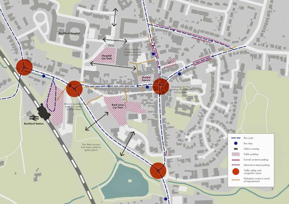
Figure 5 – Movement issues
2.8 Rochford Parish Council’s 2004 Vision Statement
A Vision Statement was published by Rochford Parish Council in 2004 and has helped to influence the Council’s policies, including the Core Strategy. This promotes Rochford as a centre for arts and crafts, as well as small specialist shops, businesses and offices. It is supportive of regeneration and development in the town centre, as well as proposals that would support the local economy and tourism.
2.9 Rochford Conservation Area Appraisal and Management Plan (2007)
An appraisal and management plan was produced for Rochford Conservation Area in 2007, to assess its character and identify any potential improvements.
The appraisal identified Rochford’s special character as “a modest but exceptionally well preserved market town centred on a cross roads”. It also highlights the prevalence of rows of one-and-a-half storey cottages, which were a typical form of development in this part of Essex.
The management plan includes a number of proposals that would help to improve the Conservation Area, including some targeted public realm and landscaping improvements.
2.10 Retail issues
A Retail & Leisure Study for Rochford District was produced in August 2008 to form part of the local planning policy evidence base. It identified Rochford town centre as the second largest within the District, behind Rayleigh, and as having a strong convenience goods sector, with capacity for additional floorspace, despite considerable leakage of main food shopping expenditure to other areas.
It was also found that whilst Rochford’s comparison goods market share is only 3.1%, there is scope for additional floorspace. The main constraint highlighted in relation to the town centre’s retail offer was the narrow range of unit sizes. The study suggests that the development of larger units or the amalgamation of adjoining units could overcome this issue.
The report recommended that a number of other improvements could be made to strengthen Rochford’s town centres position in the local economy. These were that:
-
A more permissive approach should be taken towards non-A1 uses within the vacant units at Roche Close could help to enhance the local offer and improve vitality.
-
The pedestrianisation of Market Square could provide a clearer focal point for the town centre and encourage a complementary “café culture”.
-
The town centre’s boundaries should be redrawn to provide greater definition and focus, and exclude peripheral, mainly residential areas, which have little connection with the core town centre area.
2.11 Employment issues
An Employment Land Study was produced for Rochford District in September 2008. This considered the current supply and quality of, and future need and demand for, employment space within the District. It forms part of the evidence base for Rochford District Council’s local planning policies.
Although there are no allocated employment sites within the AAP area, the Employment Land Study does consider the group of offices to the south of Back Lane at Locks Hill. Given the modest increase in long-term demand for office space forecast for the District as a whole, it recommends that the group of existing office buildings at Locks Hill are allocated as an employment site. Indeed, it is highlighted that Locks Hill is the District’s main location for offices and that an allocation would help to highlight the importance of the site for local employment.
2.12 Land ownership context
Freehold land ownership within the AAP area is highly fragmented. However, it is noted that the Council has control over a number of car parking sites, including a large area of land at Back Lane, and its offices on South Street.
2.13 Property market overview
Despite general market uncertainty since the 2007 “credit crunch”, there are certainly signs of increased activity – especially in London and the South-east, where developers and investors are beginning to re-enter the market place. A number of retailers have targets which they have been unable to meet due to the lack of development activity since 2007. However, these are focussed on a very select number of towns and both size and demographic profile of catchment populations are of paramount importance.
The headline findings from a comprehensive review of Rochford’s property market were that:
-
The town centre has an important local function, providing a range of services, but its historic core and layout places limitations on opportunities for new development.
-
Rochford is an attractive place to live with a buoyant residential market and there are a number of opportunities for new residential-led development mainly located on some infill sites at the fringe of the town centre.
-
Any residential development coming forward in the town centre will have strong competition from the significant quantum of residential development planned on the fringes of Rochford.
-
Despite not being a recognised office location, Rochford has a reasonable quantum of office floorspace relative to its size.
-
Enhancements to the town centre’s physical environment, especially around the Market Square area, will help to encourage further investment and interest from potential occupiers.
2.14 Movement issues
Rochford’s strategic movement context is summarised in Figure 4. Figure 5 provides an overview of local movement issues specifically relevant to the town centre.
Rochford town centre is focused around Market Square, at the intersection of four historic routes: North, East, South and West Streets. Their narrowness means that all but South Street accommodate vehicular traffic in one direction only.
Southend Road, Bradley Way and part of West Street act as a town centre bypass and form the main highway route, which runs along Rochford’s western border. Strategically, this route connects with London Southend Airport and Southend-on-Sea to the south and Hockley to the north-west via Hall Road. Ashingdon Road links through to the north of Hockley. South and East Streets and Dalys Road serve an important function as local collectors running along the eastern and northern boundaries of the town centre. Within the town centre itself, Back Lane, whilst narrow, plays a very important role through the provision of servicing and car park access.
There are two main car parks: one is at Back Lane (171 spaces) and the other at the rail station (202 spaces). Both of these operate on a pay-and-display basis and appear to have spare capacity. A smaller pay-and-display car park on Old Ship Lane, between East Street and North Street, provides additional car parking within the town centre, but does not appear to be particularly well-used. Additional pay-and-display spaces are available on Freight House site adjacent to the rail station.
The Market Square provides retail premises with 18 free car parking spaces, subject to a 30 minute time restriction. There is significant demand for parking in these spaces, with cars often queuing on West Street. The Market Square also accommodates a taxi rank with six spaces.
Rochford Station is served by rail services terminating at London Liverpool Street (50 minutes) and Southend Victoria (10 minutes). Trains run on a 20 minute headway during peak periods and a 30 minute headway during off-peak periods.
There is a well-established network of bus routes servicing Rochford, although legibility of routes and services is poor due to the one-way system. Bus stops are scarce through the town centre and consist of signs only, with limited (if any) information provision. Given circulation issues, buses only pass by the train station in a northbound direction. The nearest southbound bus stop is located on East Street to the east of the study area. This is a significant walk and the interchange between the rail and bus networks is therefore less than ideal.
Pedestrian movement is concentrated around the Market Square and its shops, as well as on South, North and West Streets. Pedestrian connections have been provided to the north of the Market Square in association with new development. However, pedestrian permeability to the west is considered poor with limited connections to the station and through the hospital. There are some problematic junctions for pedestrians at either end of West Street, as well as at the roundabouts on Bradley Way, which act as barriers to pedestrian movement, resulting from traffic management solutions that have prioritised vehicle capacity and speeds. Bradley Way itself prevents easy walking between the centre and the park to the south and there is the opportunity for new crossings.
Cycling provision through Rochford is of a generally acceptable standard, with the exception of the lack of provision of facilities at junctions. Resolving speed issues through the town centre’s narrow streets and slowing vehicles through improved junction treatments would have a marked impact on the cycling experience.
2.15 The Sustainability Appraisal
The Rochford AAP has been subject to a Sustainability Appraisal (SA) incorporating Strategic Environmental Assessment (SEA), as required by the European SEA Directive, UK planning legislation and the NPPF. SA seeks to promote sustainable development through the integration of environmental, social and economic considerations in the preparation of planning documents.
A Scoping Report was prepared and published in September 2012 to help ensure that the SA covered key sustainability issues relevant to Rochford town centre. This information was sent to statutory consultees for comment. Options proposed in the Rochford AAP Issues & Options paper, which included alternatives for sites as well as transport issues, were then subject to SA in February 2013. This was sent to statutory consultees and wider stakeholders for consultation from 27 February to 10 April 2013. The findings of the SA have helped to inform the policy options selected in this submission version of the AAP. In summary the findings were that:
-
Options proposing the redevelopment of buildings considered to have a negative impact on the Rochford Conservation Area would have a positive effect on heritage and townscape.
-
Options that proposed mixed use developments coupled with public realm improvements performed well against SA objectives.
-
The full or part pedestrianisation of Market Square and West Street could provide a number of positive benefits for communities, health and safety, economy and employment, cultural heritage, landscape and townscape and air quality.
-
The proposed the removal of the bus route and taxi rank from the Market Square and West Street would have the potential for a negative effect on elderly and disabled members of the community.
-
Transport options that sought to slow vehicle speeds and improve pedestrian crossings and movement through the Town Centre performed well against SA objectives relating to communities, health, accessibility and the economy.
The SA of alternatives and reasons for their selection or rejection are presented in full through the SA report accompanying the AAP on consultation.
The policies and proposals set out in this submission version of the AAP have also been subject to SA. The findings have helped to inform the development of policies and proposals and are also presented in the SA report accompanying the AAP on consultation. The Council will continue to assess the AAP, including any changes, through the SA and will document this process.