Rochford Area Action Plan Submission

Reproduced from the Ordnance Survey mapping with the permission of the Controller of Her Majesty’s Stationery Office Crown Copyright. Unauthorised reproduction infringes Crown copyright and may lead to prosecution or civil proceedings. This copy is believed to be correct. Nevertheless Rochford District Council can accept no responsibility for any errors or omissions, changes in the details given or for any expense or loss thereby caused. Rochford District Council Licence No. 100018109
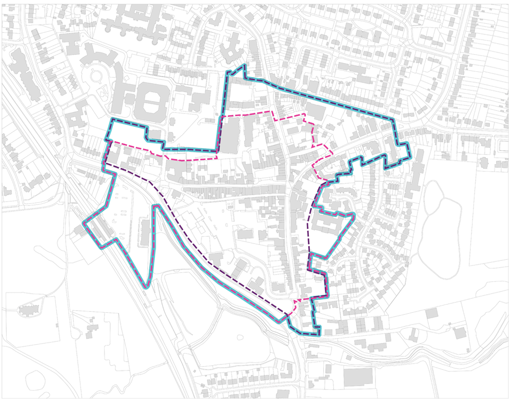
Figure 1– Rochford AAP area
(5) 1. Introduction
1.1 The big picture
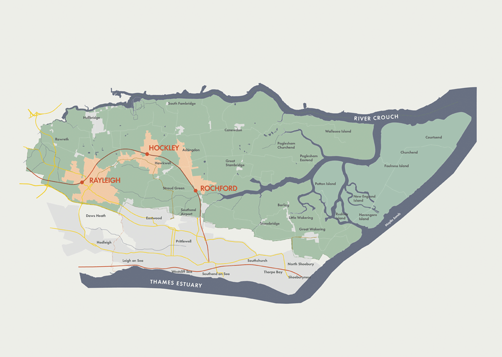
Rochford District Council is committed to preparing Area Action Plans (AAP) for its three main centres of Rayleigh, Rochford and Hockley. The AAPs will form part of the statutory development plan for Rochford District. This document focuses on guiding the development of Rochford town centre, and also considers its immediate surroundings.
The Core Strategy identifies the importance of Rochford’s well preserved and unique historic character and layout, as well as the limitations that are imposed on its function as a town centre due to the small size of most retail units. It is envisaged that Rochford will build on its heritage assets and existing position as a small market town to attract visitors and provide for the retail needs of its local population. Opportunities are also identified for improvements to the Market Square, a revised and consolidated town centre boundary and a more permissive approach towards restaurants, cafés and bars. It is important that the AAP provides a framework for carefully managed, sensitive change that respects Rochford’s historic fabric.
The AAP will form a part of the Rochford Local Plan. Alongside the adopted Core Strategy and other key planning documents, the AAP will replace the existing Replacement Local Plan (2006). The Local Plan is the new term for what was previously known as the Local Development Framework.
The next formal step is for the AAP to be published and placed on deposit for a six-week period, during which interested parties will be invited to make representations. It will then be submitted, alongside any representations received and other supporting documents, to the Secretary of State who will make arrangements for an Examination in Public by an independent Planning Inspector. The AAP will be measured against the established tests of soundness and the Planning Inspectorate will then issue a report with the inspector’s findings and a decision. If it is found sound – with or without modifications – the AAP will then be adopted.
Once adopted, the AAP will be used as a framework for the development of Rochford and during the determination of planning applications. It will be subject to the normal processes of monitoring and review.
Any representations on this pre-submission version of the Rochford AAP should be sent to Rochford District Council.
1.2 Working with our community
In recent years a series of community engagement and consultation exercises have been undertaken in Rochford which has informed the production of the Rochford AAP and the Core Strategy for the District. These have included:
-
A Placecheck and interactive web-based consultation, undertaken to inform the preparation of the Rochford AAP Issues and Options paper.
-
Consultations on the proposals set out within the Issues and Options paper.
-
A consultation on the District’s Core Strategy Submission Document that yielded feedback specifically related to Rochford.
Most recently a further stage of consultation was held on the planning policy framework for Rochford that had emerged following the Issues & Options paper. This was a public exhibition, which was held between 15 and 29 January 2013. Key messages that emerged can be summarised as follows:
-
Providing a good range of uses, activities and facilities for local people should be the planning policy framework’s main priority.
-
There was strong support for the protection of the town centre’s existing employment land.
-
The introduction of regular specialist markets and other temporary uses in the town centre was suggested.
-
Improvements to Market Square were supported and measures such as the rerouting of buses, a decrease in the size of the taxi rank, a reduction in the number of cafés, pubs, restaurants and charity shops, and better lighting and signage on nearby pedestrian routes were promoted.
-
Adequate customer car parking should be retained in the town centre.
-
There were mixed views in relation to the effect that any increased economic activity in the evening might have on the town centre; one response stated that such an increase could result in the opening of more takeaway food outlets.
-
The Highways Agency supported the emerging planning policy framework, although one response expressed concerns that the potential improvements to Bradley Way would result in traffic problems.
-
There was support for the principle of mixed-use development, however some of those that responded expressed reservations about the cumulative impact of more development, especially housing, on infrastructure.
 Reproduced from the Ordnance Survey mapping with the
permission of the Controller of Her Majesty’s Stationery
Office Crown Copyright. Unauthorised reproduction infringes
Crown copyright and may lead to prosecution or civil
proceedings. This copy is believed to be correct.
Nevertheless Rochford District Council can accept no
responsibility for any errors or omissions, changes in the
details given or for any expense or loss thereby caused.
Rochford District Council Licence No. 100018109
Reproduced from the Ordnance Survey mapping with the
permission of the Controller of Her Majesty’s Stationery
Office Crown Copyright. Unauthorised reproduction infringes
Crown copyright and may lead to prosecution or civil
proceedings. This copy is believed to be correct.
Nevertheless Rochford District Council can accept no
responsibility for any errors or omissions, changes in the
details given or for any expense or loss thereby caused.
Rochford District Council Licence No. 100018109
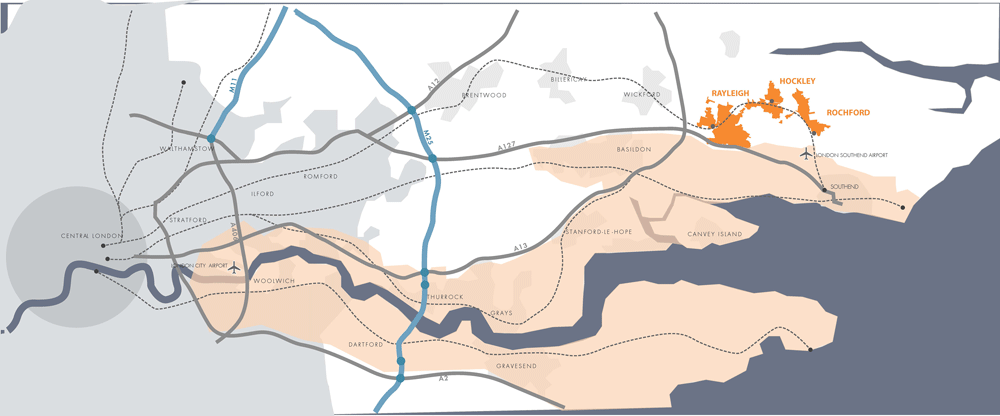
Figure 2 – Rochford’s regional context
1.3 Working with our partners
Rochford District Council is working closely with its partners to ensure that the strategic and cross-boundary implications of the Rochford AAP are fully explored and that any discussions will be taken into account in the preparation of the AAP. The Localism Act 2011 sets out a ‘duty to co-operate’ which requires such a process.
The main partner in relation to the AAP is Essex County Council (ECC), in relation to its role as Highways Authority for Rochford District and much of the wider area.
1.4 The AAP area
The AAP area comprises the existing town centre, which includes the central sections of North, East, South and West Streets, as well as the south side of Weir Pond Road, Roche Close, Back Lane and the north side of Bradley Way. The area also encompasses the rail station and Rochford District Council’s offices. This area is considered to capture Rochford’s key main town centre uses.
Most of the town centre’s retail uses are located around the historic Market Square and, to a lesser extent, on West, North and South Streets. Additional retailing can be found to the north of Market Square on the ground floors of Roche Close.
Historic backlands exist to the south of Market Square and now provide the site of the main town centre car park. Other uses, including a health centre, a hotel and a group of office buildings, are also located in this area, which is bounded by Bradley Way. The Council’s offices and the rail station are situated at the eastern and western extremities of the AAP area respectively.
Development towards the edges of the AAP area is largely residential and such development continues beyond the AAP boundary, with the Rochford Hospital site being the main exception. However, it should be noted that the area beyond Bradley Way is open space.
Reproduced from the Ordnance Survey mapping with the permission of the Controller of Her Majesty’s Stationery Office Crown Copyright. Unauthorised reproduction infringes Crown copyright and may lead to prosecution or civil proceedings. This copy is believed to be correct. Nevertheless Rochford District Council can accept no responsibility for any errors or omissions, changes in the details given or for any expense or loss thereby caused. Rochford District Council Licence No. 100018109