Core Strategy Submission Document
(10) 4. Housing
(2) Vision
In five years...
- New sustainable, residential developments are planned that are well related to infrastructure, community facilities, and play space. These have begun to be implemented. A number of residential developments, along with additional infrastructure, have been completed and are meeting the needs of local communities.
By 2025...
-
A range of high-quality, sustainable new dwellings that meet the needs of local people of all social groups are in place and integrated into communities.
-
The vast majority of the District's Green Belt remains undeveloped.
-
New infrastructure has accompanied new residential development, meeting the needs of local communities.
(3) Objectives
-
Ensure the delivery of an adequate supply of sustainable dwellings to cater for the District's growing demand, as per the requirements of the East of England Plan (2008) and a 15 year housing land supply.
-
Deliver a balanced strategy for the distribution of housing, directing housing growth to the most sustainable locations having regard to social, economic and environmental considerations.
-
Ensure the District's settlements remain viable and that rural services can be sustained.
-
Prioritise the redevelopment of appropriate brownfield sites for housing, to minimise the release of Green Belt land for development.
-
Ensure the delivery of housing which caters for the needs of all communities in terms of tenure, type and location.
-
Ensure that appropriate infrastructure accompanies new housing development.
(5) Introduction
4.1 It is important that planning ensures the provision of sufficient, good quality new homes in appropriate, sustainable locations.
4.2 The East of England Plan requires a minimum of 4600 dwellings to be provided in the District between 2001 and 2021. In addition, the Local Planning Authority is required to plan for delivery of housing for at least 15 years from the date of adoption of the Core Strategy (2010) and, in so doing, assume that the average annual requirement of 250 units will continue beyond 2021 to 2025.
(1) 4.3 Rochford's allocation is based on meeting current and future needs of the population. Current need encompasses the number of people in the District who are living within a household wanting to move to their own accommodation and form a separate household but are unable to do so (e.g. adult children). Projected need is derived from the supposition that the population will increase from 81,300 in 2007 to 87,000 by 2021.
(1) 4.4 The East of England Plan notes the provision of housing within local authorities between 2001 and 2006, and specifies the remaining provision between 2006 and 2021. Rochford District is required to accommodate 3,790 dwellings between 2006 and 2021, at an approximate average of 250 dwellings per year. Post 2021, in accordance with PPS3, the District is required to continue the development rate of 250 dwellings per year. As such, the Core Strategy addresses the location of housing provision to 2025.
4.5 The Annual Monitoring Report confirms that between 2006 and 2008 there were 618 additional dwellings completed in the District.
(9) 4.6 The 2009 Strategic Housing Land Availability Assessment (SHLAA) examined the supply of housing land and, although identified some capacity from extant permissions and other appropriate sites, also ascertained that Green Belt would have to be reallocated in order to meet the requirements of the East of England Plan as outlined below.
| Source | Dwellings | |||
| 2006-2015 | 2015-2021 | 2021-2025 | Total 2006-2025 | |
| Housing requirement (250dwellings per year) | 2250 | 1500 | 1000 | 4750 |
| Actual completions (2006‑2008) | 618 | - | - | 618 |
| Extant planning permissions | 210 | 0 | 0 | 210 |
| Existing allocations/other appropriate sites identified in Strategic Housing Land Availability Assessment | 671 | 506 | 0 | 1177 |
| Total without Green Belt release | 1499 | 506 | 0 | 2005 |
| Green Belt release required | 751 | 994 | 1000 | 2745 |
(1) 4.7 As noted within the Strategic Housing Land Availability Assessment, the Council is required to identify and allocate additional sites for development in order to meet its housing requirement. The Core Strategy sets out the general locations for housing development and approach to delivery. The precise boundaries of housing sites will be detailed in the Allocations Development Plan Document.
(4) 4.8 The concept of sustainable development is at the heart of any decisions with regards to the location of housing. The primary factors in determining the location of future housing include current infrastructure (along with opportunities to deliver future infrastructure); access to services; facilities; housing demand/need; deliverability; public transport/possibility of reducing car dependency; opportunities to utilise brownfield land; community needs and physical constraints; need to protect areas of landscape value, ecological importance and high quality agricultural land.
(10) 4.9 As described in the Spatial Characteristics, Issues and Opportunities chapter of this document, the District contains a number of settlements. Some of these settlements, although they have their own distinct identifies, are not functionally separate from their neighbours and for the purposes of the Core Strategy have been grouped together as one, namely: Rochford/Ashingdon; and Hockley/Hawkwell. These settlements/groups of settlements can be divided into four tiers, with the settlements in the higher tiers being more developed, subject to greater housing demand/need, and generally more suitable to accommodate additional housing for the reasons described above. The settlement hierarchy is as follows:
| Tier | Settlements |
| 1 | Rayleigh; Rochford/Ashingdon; Hockley/Hawkwell |
| 2 | Hullbridge; Great Wakering |
| 3 | Canewdon |
| 4 | All other settlements |
(1) 4.10 The strategy for the distribution of housing development is a balance between focussing development on the higher tier settlements, whilst allocating a proportion of the housing development to the lower tier settlements (with the exception of the fourth tier, where additional development is considered unsustainable) to ensure these established communities can be sustained and that rural services continue to be supported.
(2) 4.11 The District experiences high-levels of out-commuting and leakages of retail expenditure. Whilst the Core Strategy seeks to counter this situation through a variety of measures, the Core Strategy must also acknowledge that residents will continue to utilise centres outside of Rochford District for employment as well as other services and facilities. Therefore, the strategy for the location of housing also involves a balance between directing additional housing to areas with a close relationship to Southend, and those with a closer relationship to Chelmsford and Basildon.
4.12 In short, the Council's approach to the location of housing development can be described as a balanced strategy.
(2) The efficient use of land for housing
(3) 4.13 The Council recognises the importance of making best use of brownfield land. The Strategic Housing Land Availability Assessment identifies a realistic figure that can be accommodated within existing settlements and other appropriate land, based on the identification of specific sites.
(8) 4.14 The Strategic Housing Land Availability Assessment examines four sites that are currently allocated for employment: Eldon Way/Foundry Estate, Hockley; Rawreth Lane Industrial Estate, Rayleigh; Stambridge Mills; and Star Lane Industrial Estate, Great Wakering. In the case of all four sites, the Council believe that their redevelopment for alternatives to employment represents a more appropriate use of the land. The Council recognises, however, that additional land in more appropriate locations must be allocated for employment in order to accommodate businesses displaced from these sites. The Council's approach to this is set out in the Economic Development section of the Core Strategy.
(1) 4.15 The Strategic Housing Land Availability Assessment examines four sites that are currently allocated for employment: Eldon Way/Foundry Estate, Hockley; Rawreth Lane Industrial Estate, Rayleigh; Stambridge Mills; and Star Lane Industrial Estate, Great Wakering. In the case of all four sites, the Council believe that their redevelopment to include housing represents a more appropriate use of the land. In the case of Eldon Way / Foundry, any redevelopment should also include a range of employment uses appropriate to a town centre location. The Council recognises, however, that additional land in more appropriate locations must be allocated for employment in order to accommodate businesses displaced from these sites. The Council's approach to this is set out in the Economic Development section of the Core Strategy.

(88) Policy H1 - The efficient use of land for housing
The Council will enable the delivery of housing to meet the requirements of the East of England Plan (2008), and will ensure there is an adequate supply of land for the development of housing over a 15 year period.The Council will prioritise the reuse of previously developed land and ensure the delivery of appropriate sites within existing settlements identified by the Strategic Housing Land Availability Assessment.The Council will seek the redevelopment of Rawreth Lane Industrial Estate, Eldon Way/Foundry Industrial Estate, Stambridge Mills and Star Lane Industrial Estate for appropriate alternative uses, including residential development, with alternative employment land allocated in appropriate locations as identified in Policy ED4. Any scheme for the redevelopment of Stambridge Mills must include adequate flood mitigation measures to satisfy the PPS25 exceptions test. Appendix H1 outlines the infrastructure that will be required for the development of newly allocated housing sites.The remaining housing requirement that cannot be delivered through the redevelopment of appropriate previously developed land will be met through extensions to the residential envelopes of existing settlements as outlined in Policy H2.
Residential development must conform to all policies within the Core Strategy, particularly in relation to infrastructure, and larger sites will be required to be comprehensively planned.In order to protect the character of existing settlements, the Council will resist the intensification of smaller sites within residential areas. Limited infilling will be considered acceptable, and will continue to contribute towards housing supply, provided it relates well to the existing street pattern, density and character of the locality. The Council will encourage an appropriate level of residential intensification within town centre areas, where higher density schemes (75+ dwellings per hectare) may be appropriate.Extensions to residential envelopes and phasing
(10) 4.16 In order to fulfil the requirements of the East of England Plan and to meet the housing need of the District, the Council is required to allocate additional land for residential development, including land which is currently allocated as Green Belt, due to the limited supply of alternative land.
(5) 4.17 Whilst the Council acknowledge that the housing requirement stipulated in the East of England Plan is a minimum, it must be also mindful of the need to maintain Green Belt as far as possible.
(5) 4.18 The locations and quantums for housing development as set out in Policy H2 are such that on a settlement-by-settlement basis, when combined with development proposed through H1, a balanced strategy for housing provision is delivered.
(9) 4.19 In addition to identifying settlements where housing development will be directed to, the Core Strategy also sets out the areas around such settlements where an extension to the residential envelope is appropriate. The Council will direct development to the most sustainable locations on the edge of settlements having regard to:
-
The proximity and relationship to existing centres, facilities and services;
-
The availability of infrastructure and/or the potential for additional infrastructure to be provided for development in such areas;
-
The potential to reduce private car dependency;
-
The potential to avoid areas of constraint (such as areas at risk of flooding, sites of ecological importance, public safety zone, etc);
-
The historical, agricultural and ecological value of land;
-
The impact on highway network (including availability and impact on existing network, as well as potential for improvements to be delivered);
-
The relationship of development locations to the District's areas of employment growth;
-
The potential to create a defensible Green Belt boundary; and
-
The avoidance of coalescence with neighbouring settlements.
4.20 Development coming forward within the identified areas will have to conform to other Core Strategy policies, notably those discussed in the Transport and Community Infrastructure, Leisure and Tourism chapters. Appendix H1 outlines on-site infrastructure which will be required to be incorporated into development at each of the locations.
4.21 The Core Strategy sets out broad timings for the delivery of housing in the general locations identified. It is neither possible, nor desirable, for all sites that are ultimately allocated for housing to be delivered simultaneously.
4.22 A number of factors have been considered when drawing up the proposed general phasing of development, including the availability of infrastructure (in particular water infrastructure), the deliverability of potential sites within the areas, and the need to ensure that development is phased to allow its integration with existing communities.
(4) 4.23 It is also important to phase the loss of Green Belt land to ensure that there is not an early or excessive release which may discourage redevelopment of previously developed land or undermine town centre regeneration proposals.
(156) Policy H2 - Extensions to residential envelopes and phasing
The residential envelope of existing settlements will be extended in the areas set out below and indicated on the Key Diagram, to contribute to a five year supply of housing land in the period to 2015, and between 2015 and 2021.
| Area | Dwellings by 2015 | Dwellings 2015- 2021 |
| North of London Road, Rayleigh | 550 | |
| West Rochford | 450 | 150 |
| West Hockley | 50 | |
| South Hawkwell | 175 | |
| East Ashingdon | 100 | |
| South West Hullbridge | 250 | |
| South Canewdon | 60 | |
| Total | 775 | 1010 |
The detailed location and quantum of development will be articulated within the Allocations Development Plan Document.
Development within the above areas will be required to be comprehensively planned. A range of other uses and infrastructure (including off-site infrastructure), having regard to the requirements of the Core Strategy, will be required to be developed and implemented in a timely manner alongside housing. Appendix H1 outlines the infrastructure that will be required for each residential area, and should be read in conjunction with Policy CLT1.
The Council will maintain a flexible approach with regards to the timing of the release of land for residential development to ensure a constant five-year supply of land.
(1) Extension to residential envelopes post-2021
(4) 4.24 In considering the general development locations for post-2021 development, the same issues as for Policy H2 above have been considered, but areas identified for post 2021 development may not be immediately deliverable, or the situation vis-à-vis infrastructure and the impact on existing communities is such that their delivery earlier would not be appropriate.
4.25 The figures, with an annual average of 250 units, meet the East of England Plan's minimum in the period 2021-2025 and do not make allowance for any contribution through windfall. The figures are approximates at this stage. The exact figures will need to be determined through the Allocations Development Plan Document process or, where appropriate, Area Action Plans at a later date.
4.26 As with the pre-2021 development areas, it is important to note that development coming forward within the areas outlined in Policy H3 will have to conform to the other policies within the Core Strategy.
4.27 The Council will monitor the provision of housing and residential development may be allocated within the general locations prior to 2021 in the event that additional housing land is required.
(23) Policy H3 - Extension to residential envelopes post-2021
Post-2021, the residential envelope of existing settlements will be extended in the following areas (as indicated on the Key Diagram) to deliver the following approximate number of units post-2021. Prior to this time, Green Belt land within such areas will be safeguarded with the exception of release as per Policy H2.
| Area | Dwellings post- 2021 |
| South East Ashingdon | 500 |
| South West Hullbridge | 250 |
| West Great Wakering | 250 |
| Total | 1000 |
The detailed location and quantum of development will be articulated within the Allocations Development Plan Document.
Development within the above areas will be required to be comprehensively planned. A range of other uses and infrastructure (including off-site infrastructure), having regard to the requirements of the Core Strategy, will be required to be developed and implemented in a timely manner alongside housing. Appendix H1 outlines the infrastructure that will be required for each residential area, and should be read in conjunction with Policy CLT1.
The Council will monitor the supply and development of housing in the District and may bring forward development in these locations prior to 2021 if required to meet East of England Plan requirements, but only if infrastructure to serve such developments is also brought forward earlier.
(2) 4.28 Policies H1, H2 and H3 will deliver housing supply as illustrated in Appendix H2.
Affordable Housing
(1) 4.29 Affordable housing is defined in Planning Policy Statement 3 - Housing (PPS3) as follows:
- "Affordable housing includes social rented and
intermediate housing, provided to specified eligible
households whose needs are not met by the market. Affordable
housing should:
- Meet the needs of eligible households including availability at a cost low enough for them to afford, determined with regard to local incomes and local house prices.
- Include provision for the home to remain at an affordable price for future eligible households or, if these restrictions are lifted, for the subsidy to be recycled for alternative affordable housing provision."
(1) 4.30 The Thames Gateway South Essex Strategic Housing Market Assessment identified an acute need for affordable housing within Rochford District, equating to 131 net additional affordable dwellings per year. This amounts to 52% of Rochford's annual target. However, it is important that viability is considered - the Council recognises the need to set a requirement that is economically viable. As such, 35%, being the indicative aim for the region as a whole as set out in the East of England Plan is considered appropriate as a local requirement.
(1) 4.31 The Council's Housing Strategy (2009) acknowledges the severity of the need for affordable housing in the District and one of its key priorities is to maximise the provision of affordable housing through the planning system. The 2009 Housing Strategy's action plan includes the aim to achieve 35% affordable housing on future development sites.
(1) 4.32 The Council recognises the need to ensure that affordable housing policies, or any other form of planning obligations, do not place an undue financial burden on developers such to prevent the delivery of development. The economic viability of affordable housing will vary depending on the market conditions at any given time. As such, the Council will continue to monitor the 35% target and may relax this requirement in specific cases where developers are able to demonstrate conclusively that for a particular development site the target is unachievable.
(12) Policy H4 - Affordable Housing
At least 35% of dwellings on all developments of 15 or more units, or on sites greater than 0.5 hectares, shall be affordable. These affordable dwellings shall be tenure-blind and well integrated into the layout of new residential developments such that they are spread ("pepper potted") throughout larger developments, whilst having regard to the management requirements of Registered Social Landlords.
The Council will aim for 80 percent of affordable housing to be social housing, 20 percent intermediate housing. The Council will constantly review the affordable housing needs of the District and developers should consult with the Council's Housing Strategy team to ensure their proposals meet the Council's needs before submitting planning applications.
The requirement for the provision of affordable housing will only be relaxed in highly exceptional circumstances, for example where constraints make on-site provision impossible or where the developer is able to definitely demonstrate that 35% provision will be economically unviable, rendering the site undeliverable. In such cases the Council will negotiate the proportion of affordable dwellings based on the economic viability calculations. It is expected that affordable housing will be provided on each development site; in rare cases, taking account of particular site characteristics, the affordable housing contribution may be provided by way of a commuted sum towards off-site affordable housing.
Dwelling Types
(1) 4.33 Historically, the mix of house types in the District has tended to have been dominated by larger houses at the higher end of the market. Whilst this has contributed to the character of the District as it is today, the concern is that if such a pattern were to continue it would not meet the needs of the whole community, particularly as the trend is for smaller household sizes due to social and demographic changes.
4.34 The Strategic Housing Market Assessment for Thames Gateway South Essex notes that although the majority of household demand growth is expected to result from increasing single person households, a high proportion of these are existing older households who already have housing and are unlikely to downsize.
4.35 However, there is a high demand locally for three-bedroom properties for families and it should be noted that the demand for house types can change over relatively short periods of time due to a variety of circumstances, and may vary across the District. As such it is necessary to keep the District's housing need under constant review.
4.36 It is important that a mix of house types is provided on larger sites coming forward to deliver mixed communities, as opposed to developments which cater entirely for only one demographic group.
(7) Policy H5 - Dwelling Types
New developments must contain a mix of dwelling types to ensure they cater for all people within the community, whatever their housing needs. The development of both affordable and market housing should have regard to local need. Developers should consult with the Council's Housing Strategy team in order to determine the required mix of house types prior to submitting planning applications.
A proportion of the affordable housing provision within developments will be required to be in the form of three-bedroom or larger dwellings.
4.37 The housing allocation for Rochford District is based on meeting the current and future needs of the local population, but the development to meet this need must be sustainable not just socially, but also environmentally. The environmental issues that will apply to new housing, in addition to other forms of development are set out in the Environmental Issues chapter of this document. Character is also important and is discussed in the Character of Place section.
Lifetime Homes
4.38 As acknowledged in the Sustainable Community Strategy, the need to meet the needs of an ageing population is, whilst not unique to Rochford, particular prevalent in the District. Furthermore, the issue is particularly pertinent to the subject of housing provision. It is important that housing is designed to be flexible to changes in people's circumstances.
4.39 Lifetime homes are homes designed for people to remain in for as much of their life as possible and to this end are adaptable to the differing needs of different stages of their life cycle. Building Regulations now require new dwellings to have access and facilities for disabled people and in being so designed they are expected to help people with reducing mobility to remain longer in their homes. The Lifetimes Homes Standard promoted by the Joseph Rowntree Foundation goes further to provide housing that is more flexible and adaptable than that required by Part M of the Building Regulations and so are more suitable for older and disabled people.
4.40 By requiring homes to meet the Lifetime Homes Standard the Council are not simply applying a "one size fits all" approach, or forcing all homes to be the same - the Lifetime Homes Standard is about ensuring homes can be easily adapted to meet changing needs, for example, by having staircases that are wide enough to accommodate a chairlift, or doorways wide enough for wheelchairs.
4.41 Lifetime Homes are suitable for people throughout their lives and by ensuring that homes meet this standard, residents will be able to remain independent as they get older, or develop physical disabilities. All residents will age and anyone's circumstances can change. As such it would not be appropriate for only a proportion of new housing development to be flexible to meet people's changing circumstances.
4.42 It is little more difficult at the design stage to achieve the Lifetime Homes Standard over the requirements of the Building Regulations, and whilst it may be more expensive to implement, costs should reduce as the standard becomes widely accepted.
4.43 The Essex Joint Strategic Needs Assessment notes that many older people living in Essex cannot afford to adapt their home to meet their needs, or to keep it in a good state of repair. Such a situation has the potential to worsen given that the population is ageing, and highlights the importance of the Lifetime Homes Standard.
4.44 Lifetime Homes are not specifically properties for people with mobility problems and are not necessarily wheelchair standard accommodation. In addition to the Lifetime Homes Standard, it is important that a proportion of housing be wheelchair accessible so as to ensure new developments are socially inclusive.
(6) Policy H6 - Lifetime Homes
All new housing developments will be required to comply with the Lifetime Homes Standard.
In addition, at least 3% of new dwellings on developments of 30 dwellings or more will be required to be built to full wheelchair accessibility standards. In the case of developments comprising fewer than 30 dwellings, at least one dwelling will be expected to be built to full wheelchair accessibility standards.
In the case of developments comprising�between 10 and 30 dwellings, at least one dwelling will be expected to be built to full wheelchair accessibility standards.
Gypsy and Traveller Accommodation
4.45 Planning must meet the accommodation needs of all communities, including Gypsies and Travellers. The need and demand for Gypsy and Traveller sites in the District has, historically, been very low, especially when compared with other areas of Essex. However, even this low demand has not been met in the past.
4.46 The East of England Regional Assembly has prepared a single-issue review on Gypsy and Travellers accommodation that has resulted in the allocation within the East of England Plan of 15 pitches to be provided in Rochford District by 2011.
4.47 Given the historically low demand within the District, provision for any additional pitches post 2011 will be subject to further review of need.
(8) Policy H7 - Gypsy and Traveller Accommodation
The Council will allocate 15 pitches by 2011, as per the East of England Regional Assembly's single-issue review.
In allocating pitches the Council will examine the potential of current unauthorised sites to meet this need and will consider granting them planning consent subject to advice in Circular 1/2006 - Planning for Gypsy and Traveller Caravan Sites. Sites will be allocated in the west of the District, where transport links and access to services are better. In allocating sites consideration will include:
-
The promotion of peaceful and integrated co-existence between the site and the local community;
-
The wider benefits of easier access to GP and other health services;
-
Children attending school on a regular basis;
-
The provision of a settled base that reduces the need for long-distance travelling and possible environmental damage caused by unauthorised encampment on alternative sites; and
-
The need to direct sites away from areas at high risk of flooding, including functional floodplains, given the particular vulnerability of caravans
(26) Appendix H1
| Location | New infrastructure and services to accompany residential development |
| North of London Road, Rayleigh |
|
| West Rochford |
|
| West Hockley |
|
| South Hawkwell |
|
| East Ashingdon |
|
| South West Hullbridge |
|
| South Canewdon |
|
| South East Ashingdon |
|
| West Great Wakering |
|
| Rawreth Industrial Estate |
|
| Eldon Way / Foundry |
|
| Stambridge Mills |
|
| Star Lane Industrial Estate |
|
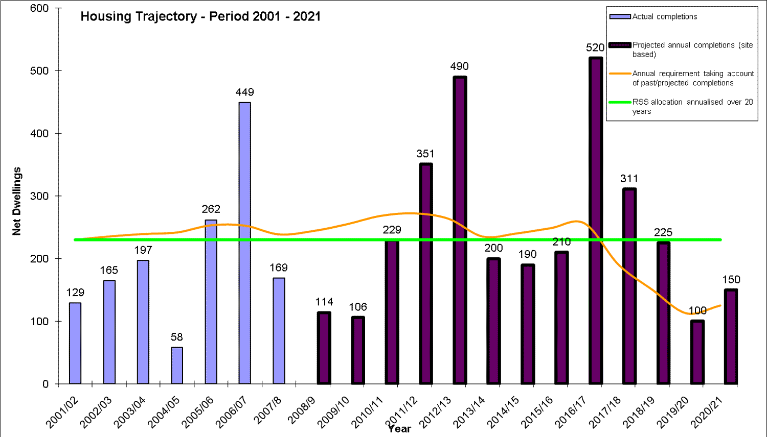
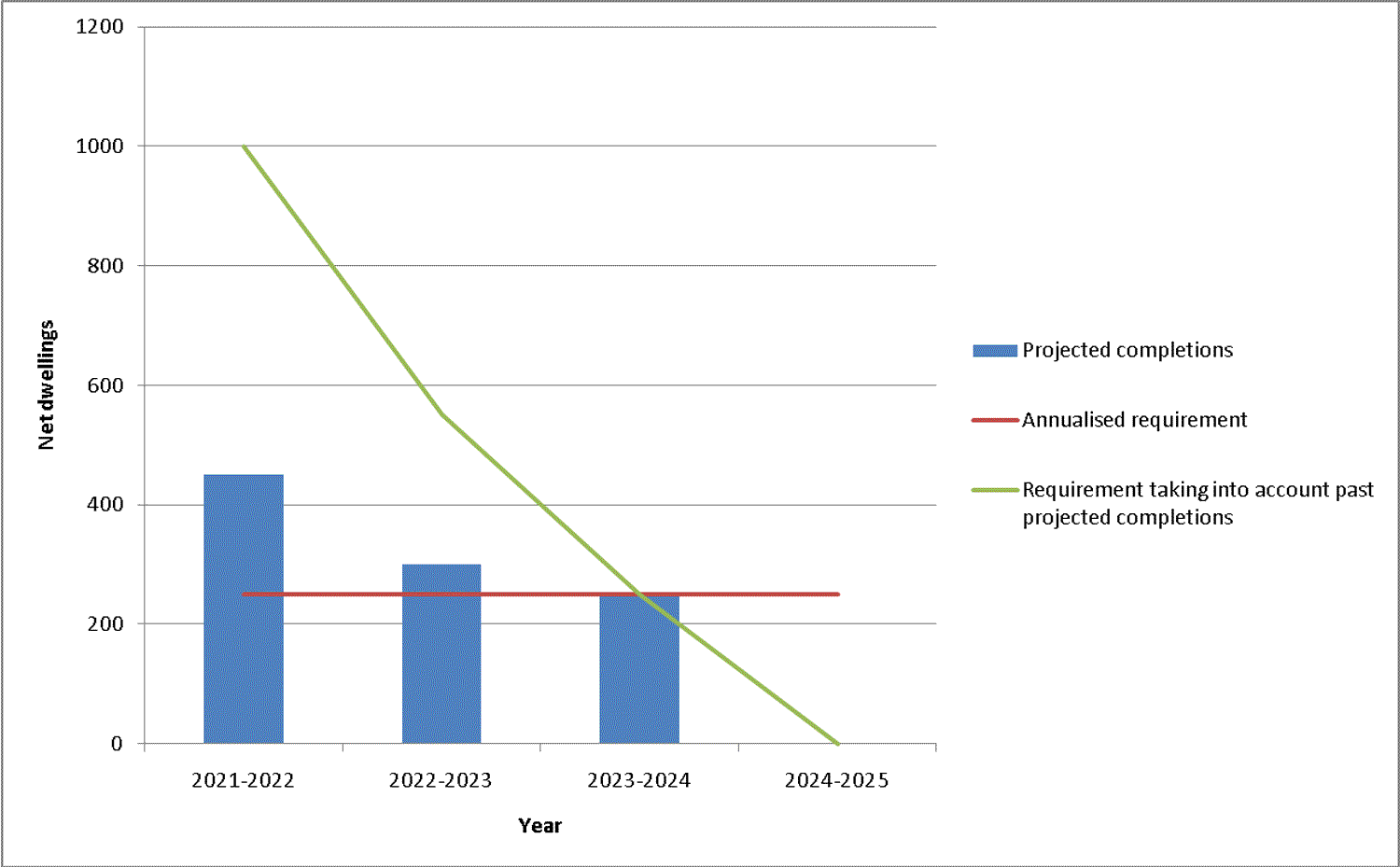
(6) Appendix H2
Housing trajectory 2001-2021 from combination of Policies H1and H2
Housing trajectory 2021 to 2025 from Policy H3
Breakdown of 2001-2021 housing trajectory by source
| Source | Net dwelling completions | ||||||||||||||
| 2006-07 | 2007-08 | 2008-09 | 2009-10 | 2010-11 | 2011-12 | 2012-13 | 2013-14 | 2014-15 | 2015-16 | 2016-17 | 2017-18 | 2018-19 | 2019-20 | 2020-21 | |
| Actual Completions 2006-2008 | 449 | 169 | 0 | 0 | 0 | 0 | 0 | 0 | 0 | 0 | 0 | 0 | 0 | 0 | 0 |
| Extant permissions | - | - | 104 | 106 | 0 | 0 | 0 | 0 | 0 | 0 | 0 | 0 | 0 | 0 | 0 |
| Redevelopment of identified employment allocations | - | - | 0 | 0 | 125 | 125 | 0 | 0 | 75 | 50 | 50 | 100 | 80 | 115 | 75 |
| Other appropriate sites identified in SHLAA | - | - | 10 | 0 | 104 | 101 | 41 | 0 | 90 | 0 | 0 | 36 | 0 | 0 | 0 |
| Extensions to residential envelopes | - | - | 0 | 0 | 0 | 125 | 350 | 200 | 100 | 160 | 225 | 175 | 150 | 150 | 150 |
All dwelling completions post-2021 from extensions to residential envelopes.