Draft Local Plan - Regulation 18
12. Exploring Future Development Options
12.1. Site Principles
SO1 Strategic Site Principles
SO2 General Site Principles and Site-Specific Policy Themes
Context and Background
12.1.1. The Local Plan must provide clarity on the principles that will guide development across Rochford District. These principles are intended to ensure that all sites, whether small, medium, or large, are planned and delivered in a way that supports sustainable growth, protects environmental assets, and meets community needs. They reflect national policy requirements for sustainable development, infrastructure-led growth, and high-quality design, as set out in the National Planning Policy Framework.
12.1.2. At this stage, the draft Local Plan does not allocate sites. Instead, it identifies sites for further testing through the Site Assessment Methodology Paper (SAM) and seeks views on the principles that will inform future decisions. These principles will underpin site selection and shape site-specific policies when allocations are made in later stages of the plan.
12.1.3. The approach recognises that:
- Development should make best use of brownfield land and sustainable locations.
- Infrastructure must be delivered alongside growth.
- Environmental and heritage assets must be safeguarded.
- Larger strategic sites require additional expectations to ensure comprehensive masterplanning and infrastructure provision.
12.1.4. These principles aim to provide early clarity for communities, developers, and stakeholders, while allowing flexibility for detailed design and delivery through future planning stages.
Summary of Consultation Feedback
12.1.5. Previous consultations, including the Spatial Options 2021 and earlier engagement on site assessment, highlighted several key themes:
- Support for clear principles: Respondents welcomed guidance on what makes a site suitable and what future policies should require.
- Brownfield first: Strong preference for prioritising previously developed land, while acknowledging that brownfield capacity is limited.
- Urban focus and extensions: Broad support for focusing growth in higher-order settlements where services and transport are available or can be improved.
- Strategic sites (mixed views): Some respondents recognised the potential of large-scale development to deliver infrastructure and community facilities, while others raised concerns about environmental impact, traffic, and loss of open land.
- Infrastructure concerns: Consistent emphasis on the need for transport improvements, school places, healthcare facilities, and utilities to accompany development.
- Environmental and heritage protection: Strong desire to safeguard sensitive landscapes, biodiversity, and heritage assets.
- Clarity on site-specific policies: Feedback indicated that communities and developers want certainty about what will be expected from each allocated site, including housing mix, green space, transport links, and infrastructure.
12.1.6. Overall, the feedback supports a balanced approach: clear principles for all sites, additional requirements for strategic-scale development, and detailed site-specific policies to provide certainty at allocation stage.
Site Principles
SO1 – Strategic Site Principles
- Development proposals for strategic sites of 1,400+ homes must:
- prepare a Strategic Masterplan in partnership with Rochford District Council, Essex County Council, infrastructure providers, statutory bodies, and the local community, ensuring conformity with the Local Plan and supplementary planning documents;
- provide social and physical infrastructure at a pace aligned with development phases, and contribute to strategic highway improvements and other requirements set out in the Infrastructure Delivery Plan;
- deliver an integrated network of open spaces, sport and recreation facilities, allotments, sustainable drainage, landscaping, and biodiversity measures;
- provide highway solutions to mitigate impacts on the strategic and local road network developed collaboratively with Essex County Council;
- ensure walk/cycle/bus connectivity and integration with existing networks, with direct access to rail stations and nearby town centres;
- deliver education facilities (e.g., primary and through schools), childcare, healthcare (including GP provision), and multi-purpose community spaces. Include facilities for youth services, creative industries, and play;
- provide a mix of high-quality homes, including affordable housing, and include employment floorspace targeted at SMEs and local centres with retail and community uses;
- achieve Net Zero carbon in operation, incorporate flood resilience, sustainable drainage, and biodiversity net gain (minimum 10%);
- respect topography, heritage assets, and integrate with existing settlements, supported by a Heritage Impact Assessment.
SO2 – General Site Principles and Site-Specific Policy Themes
- All sites that may be allocated in future iterations of the Local Plan should:
- accommodate ≥5 homes (or ≥0.25ha employment). Smaller proposals are anticipated through windfall and will be assessed at planning application stage;
- be adjacent to existing urban areas with access to schools, shops and employment; or, if not adjacent, be large enough (≥1,400 homes) to provide their own local facilities;
- make best use of previously developed land, recognising overall brownfield capacity is limited;
- avoid being wholly/mostly within Flood Zones 2 or 3, consistent with the sequential test;
- avoid locations near protected habitats where impacts are unlikely to be satisfactorily mitigated; avoid areas of special landscape quality;
- be within easy walking distance of frequent bus or rail services to reduce car dependency;
- prioritise land that contributes less strongly to Green Belt purposes (as per national guidance), protecting the most important areas;
- direct development to lower grade agricultural land where loss is unavoidable;
- avoid unacceptable impacts on heritage assets that cannot be mitigated;
- When sites are allocated, individual policies will provide clarity on:
- estimated capacity (homes/employment), housing mix (including affordable/specialist and Gypsy & Traveller provision where appropriate), density parameters and key design responses to constraints (e.g., proximity to listed buildings);
- landscaping, children’s play, amenity spaces, BNG delivery and protection/enhancement of important trees, hedgerows and habitats; strategic spaces (e.g., a country park) where justified;
- primary access point(s), junction improvements, strategic and local walking/cycling connections, bus service enhancements and associated contributions—in consultation with ECC (Highways);
- on-site provision or S106/CIL contributions for education, health, utilities and local services; supporting uses on larger sites (e.g., local shops/services) to establish complete communities;
- site-specific mitigation (amenity, lighting, compatible uses) and, for complex/very large schemes, requirements for supplementary documents (e.g., Development Plan Document, masterplan, design code/brief), each subject to public consultation.
Which Strategic Objectives do these policy options relate to?
- SO1: Housing to meet local needs
- SO2: Employment and commercial space to help our businesses grow
- SO5: Delivery of Infrastructure
- SO12: Sustainable patterns of growth
- SO13: Ensuring High-Quality Design
Reasoned Justification
12.1.7. These policy options are designed to provide clarity and certainty for all stakeholders about the principles that will guide future development across Rochford District. They establish a framework that applies to sites of all scales, ensuring growth is sustainable, well-integrated, and aligned with national and local objectives.
12.1.8. Policy Option SO1 addresses the unique challenges and opportunities presented by strategic sites of 1,400+ homes. These locations have the potential to deliver significant housing, employment space, and infrastructure, but require comprehensive masterplanning to manage impacts on transport, utilities, and community services. Setting clear expectations for infrastructure delivery, connectivity, and environmental resilience ensures these large-scale developments create complete, sustainable communities rather than isolated housing estates.
12.1.9. Policy Option SO2 provides a consistent set of principles for all other sites that may be allocated in future iterations of the Local Plan. These principles prioritise brownfield land and accessible locations, safeguard environmental and heritage assets, and ensure development avoids areas of high flood risk or sensitive landscapes. They also establish thresholds for scale and infrastructure requirements, balancing flexibility for smaller sites with certainty for larger allocations. By requiring site-specific policies at allocation stage, SO2 ensures clarity on housing mix, green space, transport improvements, and community facilities, reducing ambiguity for developers and communities alike.
Together, SO1 and SO2 create a balanced approach:
- Strategic sites deliver comprehensive masterplanning and infrastructure to support significant growth.
- General principles apply to all sites, ensuring sustainable patterns of development and protecting the district’s environmental and heritage assets.
12.1.10. This framework supports the Local Plan’s strategic objectives by promoting high-quality design, climate resilience, biodiversity net gain, and timely infrastructure delivery. It also embeds economic opportunities and social infrastructure within new communities, while maintaining flexibility for detailed design and delivery through future planning stages. By setting these principles now, the Local Plan can shape future proposals to be deliverable, resilient, and beneficial to both new and existing communities.
Have Your Say…
12.2. Sites Identified for Testing
Background and Context
12.2.1. As part of preparing the new Local Plan, the Council has undertaken a comprehensive site assessment process, guided by the Site Assessment Methodology Paper. This methodology applies a consistent and transparent approach to evaluating potential development sites against a range of criteria, including sustainability, deliverability, infrastructure capacity, environmental constraints, and alignment with strategic objectives.
12.2.2. As set out within other parts of this Local Plan, we have been given national government housing requirements, as well as independently assessed needs for Gypsy and Traveller accommodation, and sites to provide employment, retail and services for the increased population.
12.2.3. We have used the guiding principles set out in the Local Plan, alongside the evidence collected so far, to review all sites submitted by landowners and developers. This analysis is documented in the Site Assessment Methodology (SAM), which underpins our approach to site selection.
12.2.4. Using this methodology, we have identified:
- Potentially suitable sites for development.
- Marginal sites that may become suitable with further evidence.
- Sites not currently considered suitable, though this judgement could change with additional evidence.
- Discounted sites, which we do not think are suitable for development and will not be taken forward or subject to further evidence gathering.
12.2.5. The inclusion of these sites at this stage does not mean they are preferred sites or proposed allocations. They are not being promoted as part of the Regulation 18 Local Plan. Instead, they have been identified for further testing to help the Council understand their potential suitability and deliverability. This process will inform future decisions on site allocations in later stages of the Local Plan.
12.2.6. Further testing will involve more detailed technical work, including transport modelling, utilities assessments, flood risk analysis, and environmental studies, as well as engagement with infrastructure providers and stakeholders.
12.2.7. To inform decisions on allocations in the next iteration of the Local Plan, we are seeking your views on all the sites we have assessed, including those we have discounted. Your feedback will be considered alongside the detailed evidence base before a final decision is made on which sites should be allocated to meet Rochford’s housing and employment needs.
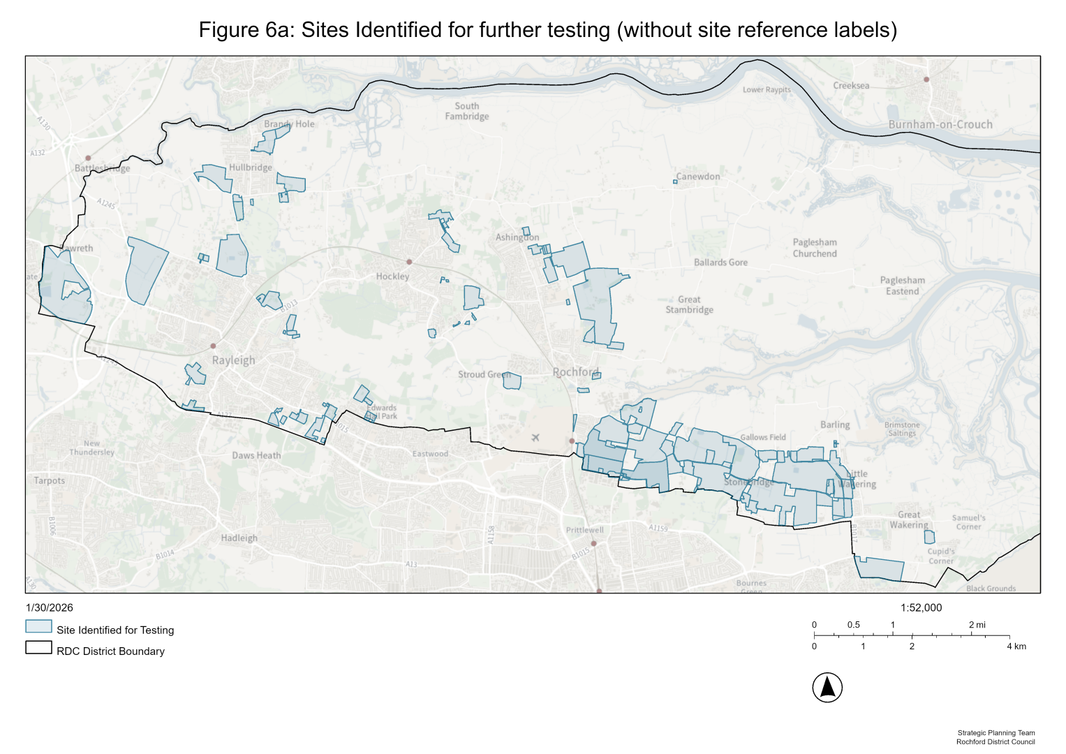
12.2.8. A map of the location of the potentially suitable and marginally suitable sites can be found at Figures 6a and 6b. For more detail on our assessment, please see the Site Assessment Methodology paper which is available at www.rochford.gov.uk/new-local-plan/evidence. For a map of all submitted sites, please see our interactive map at https://rochford.opus4.co.uk/planning/localplan/maps/reg18# .
Have your say...
Question – Do you have any comments on sites that have not been identified for testing, i.e. marginal omission or clear omission sites?
Baseline and Windfall Figures
12.2.9. The baseline figures represent the starting point for housing supply as of March 2025. These include:
- Completions (2023–24 and 2024–25):
Homes that have already been built or are expected to be completed during the new Local Plan period. - Extant Planning Permissions (-10% for non-completions):
Homes with planning permission that are likely to be delivered, adjusted by a 10% discount to account for potential non-implementation. - Allocations without planning permission:
Sites allocated in the current Local Plan but not yet granted planning permission. - All other sites:
Smaller commitments or sites not captured in the above categories.
12.2.10 These baseline figures ensure that existing commitments are factored into the overall housing supply before considering new sites.
Windfall Allowance
12.2.11. The windfall allowance accounts for unexpected housing sites that come forward during the plan period but are not specifically allocated in the Local Plan. These are typically small-scale developments such as infill plots, conversions, or redevelopment of previously developed land.
12.2.12. The allowance is set at 450 homes for the plan period, based on historic trends and evidence of past delivery.
Categories of Sites Identified
12.2.13. The sites identified through the assessment process fall into three broad categories:
- Small Sites – Typically below 1 hectare in size, these sites could provide modest levels of housing and help support incremental growth within existing settlements.
- Urban Extensions – Larger sites located on the edge of existing towns and villages, offering opportunities for more substantial housing development alongside supporting infrastructure and services.
- Strategic and Large-Scale Development – Very large sites capable of delivering significant new neighbourhoods, including housing, employment, green space, and community facilities. These sites would require comprehensive masterplanning and infrastructure investment to ensure sustainable delivery.
Table 11: Summary of potential housing supply
|
Source |
Housing delivery in plan period |
Housing delivery beyond plan period |
|
Local Plan Baseline (March 2025) |
||
|
Completions (2023-24) |
285 |
0 |
|
Completions (2024-25) |
415 |
0 |
|
Extant Planning Permission (-10% for non-completions) |
1,202 |
0 |
|
Allocations without planning permission |
183 |
0 |
|
All other sites |
184 |
0 |
|
Sites identified in Site Assessment Methodology Paper |
||
|
Potential Small Sites |
294 |
0 |
|
Urban Extensions |
5,545 |
0 |
|
Strategic & Large-Scale Development |
6,178 |
4,897 |
|
Windfall allowance |
||
|
Windfall |
450 |
N/A |
|
Total |
14,736 |
4,897 |
Table 12: Sites identified for further testing
Please note that each site has a corresponding comment box. This is asking whether you have a comment to make on the site, with the option of ‘yes’ or ‘no’ provided in response to this.
|
Ref |
Historic Ref |
Site Name |
Proposed Use |
Housing delivery in plan period |
Housing delivery beyond plan period |
|
Small Sites (below 1ha in size) |
|||||
|
CFS018 |
Land between The Grange and Red Roof in Ironwell Lane |
Residential |
14 |
0 |
|
|
CFS026 |
Land east of Kingsway, Hullbridge |
Residential |
18 |
0 |
|
|
CFS029 |
Land at Turrett Farm, Napier Road, Rayleigh |
Residential |
27 |
0 |
|
|
CFS047 |
36 Connaught Road Rayleigh, SS6 8UX Land adjacent to Dunsmure, The Drive Rear of Rutland, The Drive, Rayleigh |
Residential |
17 |
0 |
|
|
CFS059 |
Land at Sandhill Road, Eastwood |
Residential / Education / Mixed / Health / Leisure / Recreation / Industrial / Offices / Cultural |
17 |
0 |
|
|
CFS060 |
Land west of Little Wakering Road, Little Wakering |
Residential / Education / Mixed / Health / Leisure / Recreation / Industrial / Offices / Cultural |
25 |
0 |
|
|
CFS086 |
Land between Rivendell and Brookside, Napier Road, Rayleigh |
Residential |
11 |
0 |
|
|
CFS094 |
Land west of Ash Green, Canewdon |
Residential |
14 |
0 |
|
|
CFS118 |
The Paddock by Clements Hall Way, Rectory Road, Hawkwell |
Residential |
12 |
0 |
|
|
CFS129 |
Boness, Canewdon View Road, Rochford |
Residential |
18 |
0 |
|
|
CFS130 |
Lavender Lodge, Canewdon View Road, Rochford |
Residential |
23 |
0 |
|
|
CFS204 |
Land at / r/o 139 Greensward Lane, Hockley, Essex |
Residential |
10 |
0 |
|
|
CFS212 |
Land at Rayleigh Downs Rd & Arterial Rd, Rayleigh |
Housing or offices or mixed |
20 |
0 |
|
|
CFS218 |
Land at Oxford Road, Rochford |
Housing |
19 |
0 |
|
|
CFS088 |
Land between The Brambles and Bo Via, Clements Hall Lane, Hawkwell |
Housing |
19 |
0 |
|
|
CFS258 |
Site at Little Wakering Road, Little Wakering |
Housing |
10 |
0 |
|
|
CFS273 |
241 Rectory Road, Hawkwell, SS5 4LF |
Housing |
10 |
0 |
|
|
CFS280 |
Site at Temple Farm, Sutton Road, Rochford |
Housing |
10 |
0 |
|
|
Urban Extensions |
|||||
|
CFS013 |
Land at rear of Newton Hall Gardens, Ashingdon |
Residential, Employment, Open Spaces, Mixed or Cultural |
111 |
0 |
|
|
CFS015 |
Land south-east of the junction of Lower Road and Hullbridge Road, Hullbridge |
Residential |
70 |
0 |
|
|
CFS023 |
Land north and east of Malvern Road, Hockley |
Residential |
174 |
0 |
|
|
CFS031 |
Land north of Rawreth Lane and east of Parkhurst Drive, Rayleigh |
Housing, education, health, leisure/recreation, mixed |
37 |
0 |
|
|
CFS033 |
Land south of Pooles Lane, Hullbridge |
Residential |
158 |
0 |
|
|
CFS037 |
The Ramblers & Dahlia Lodge, Eastwood Rise, Leigh |
Residential |
43 |
0 |
|
|
CFS044 |
15 Southview Close, 270 Eastwood Road, and land to the rear of 270 Eastwood Road (Acacia Nurseries), Rayleigh |
Residential |
113 |
0 |
|
|
CFS048 |
287 Daws Heath Road, Rayleigh SS6 7NS |
Residential |
41 |
0 |
|
|
CFS050 |
Former Castle Point and Rochford Adult Community College, Rocheway, Rochford |
Residential |
50 |
0 |
|
|
CFS053 |
Land south of 38 and 39 Wellington Road, Rayleigh |
Residential |
90 |
0 |
|
|
CFS054 |
Land rear of 17 and 19 South View Close, Rayleigh |
Residential |
52 |
0 |
|
|
CFS063 |
Land south of Watts Lane, Rochford |
Residential / Education / Mixed / Health / Leisure / Recreation / Industrial / Offices / Cultural |
58 |
0 |
|
|
CFS066 |
Circus Field, Land west of Southend Road, Rochford |
Residential / Education / Mixed / Health / Leisure / Recreation / Industrial / Offices / Cultural |
40 |
0 |
|
|
CFS068 |
Land at Lower Wyburns farm, to the south of Daws Heath Road, Rayleigh |
Residential / Education / Mixed / Health / Leisure / Recreation / Industrial / Offices / Cultural |
215 |
0 |
|
|
CFS070 |
Land south of Conway Avenue and west of Shoebury Road, Great Wakering |
Residential / Education / Mixed / Health / Leisure / Recreation / Industrial / Offices / Cultural |
150 |
0 |
|
|
CFS077 |
Land to the north of Great Wheatley Road, Rayleigh |
Housing, education, health, leisure/recreation, industrial, offices, mixed, cultural |
140 |
0 |
|
|
CFS084 |
Land south of Hall Road, Rochford |
Residential |
320 |
0 |
|
|
CFS087 |
Land between Western Road and Weir Farm Road, Rayleigh |
Residential |
140 |
0 |
|
|
CFS095 |
Peggle Meadow, Southend Road, Rochford |
Residential |
117 |
0 |
|
|
CFS098 |
Land north of Napier Road, Rayleigh |
Residential |
51 |
0 |
|
|
CFS100 |
Land at Nevendon Salvage and adjacent land to the east, Lower Road, Hullbridge, Essex |
Residential |
98 |
0 |
|
|
CFS102 |
Land to the north of Eastwood Road, east of The Drive, south of Warwick Road, Rayleigh |
Mixed |
133 |
0 |
|
|
CFS105 |
Land north of Hambro Hill, Rayleigh |
Residential |
315 |
0 |
|
|
CFS111 |
Land north of Coombes Grove, Rochford |
Mixed |
120 |
0 |
|
|
CFS007 |
Land north of Brays Lane, Ashingdon |
Residential |
300 |
0 |
|
|
CFS127 |
Eastwood Nurseries, off Bartletts, Rayleigh |
Residential |
232 |
0 |
|
|
CFS131 |
Beehive, Canewdon View Road, Rochford |
Residential |
42 |
0 |
|
|
CFS134 |
Land between Eastwood Rise and Rayleigh Avenue, Eastwood |
Residential |
180 |
0 |
|
|
CFS006 |
Land North of Watery Lane and West of Buttermere Gardens, Hullbridge |
Residential |
350 |
0 |
|
|
CFS162 |
Land to the rear of 158 Rawreth Lane and west of Parkhurst Drive, Rayleigh, Essex, SS6 9RN |
Residential |
34 |
0 |
|
|
CFS180 |
Land East of Highcliff Crescent, Ashingdon |
Housing |
65 |
0 |
|
|
CFS190A |
Land south of Pooles Lane, Hullbridge |
Housing |
388 |
0 |
|
|
CFS194 |
Land North of Rectory Road, Hawkwell |
Housing |
200 |
0 |
|
|
CFS217 |
Land at Doggetts Chase, Rochford |
Housing |
90 |
0 |
|
|
CFS263 |
Land at Pulpits Farm, Greensward Lane, Hockley |
Housing |
201 |
0 |
|
|
CFS128 |
Long Lane, Hullbridge |
Housing |
215 |
0 |
|
|
CFS267 |
Upper Edwards Hall Farm, Eastwood |
Housing |
70 |
0 |
|
|
CFS276 |
Land at Rawal Pindi Nurseries, Hawkwell |
Housing |
153 |
0 |
|
|
CFS277A |
Rayleigh Club, Rayleigh |
Housing |
189 |
0 |
|
|
Strategic & Large-Scale Development |
|||||
|
CFS034 |
Tithe Park, Poynters Lane, Great Wakering |
Residential |
820 |
230 |
|
|
CFS163 CFS164(a) |
Lubards Lodge Farm |
Mixed |
550 |
0 |
|
|
CFS146 CFS147 CFS297 |
Land West of Rayleigh (LWOR) Option B - Wolsey Park |
Residential |
808 |
267 |
|
|
CFS222(a) |
Land West of Rayleigh (LWOR) Option A - Dollymans Farm |
Housing |
1,000 |
300 |
|
|
CFS260 |
Land North of Southend (LNOS) |
Housing and supporting uses |
1,500 |
3,500 |
|
|
CFS261 |
Land East of Rochford (LEOR) |
Housing and supporting uses |
1500 |
600 |
|
with%20site%20reference%20labels).png)
Have Your Say…