Draft Local Plan - Regulation 18
8. Vibrant Town Centres
8.1. Retail and Leisure
Strategic Policy TC1 – Future Retail and Leisure Needs
Context and Background
8.1.1. Rochford District is characterised by its three town centres of Rayleigh, Rochford and Hockley, each of which have their own distinctive identity and differing range of shops and services. Across the wider District, a series of neighbourhood and village shopping parades also fulfil important roles at the heart of their communities. These centres are key to everyday life for most residents and businesses and are important contributors to local economies, communities and identities. They provide a wide range of both everyday (convenience) and specialist (comparison) retailers, in addition to food & drink, leisure, entertainment and services, office accommodation; and key public facilities (e.g., healthcare, libraries and council services).
8.1.2. In addition, the District’s rural and semi-rural areas, including its villages and hamlets, contain a range of small retail facilities catering to local needs. Large garden centres and the Airport Retail Park draw visitors from a wider catchment, whilst a number of historic country pubs provide a strong food and beverage offer which draws upon the District’s greenery and tranquillity. As a district with a relatively small and dispersed population situated close to larger population centres, many residents travel to neighbouring local authority areas to access a wider range of goods and services, particularly neighbouring Southend-on-Sea, Basildon and Chelmsford. The District experiences high rates of ‘leakage’ of shoppers to elsewhere, suggesting improvements to the local retail offer could reduce the need to travel elsewhere.
8.1.3. The NPPF states that policies and decisions should support the role that town centres play at the heart of local communities, by taking a positive approach to their growth, management and adaptation, through measures such as defining a network and hierarchy of town centres; promoting their long-term vitality and viability by allowing them to grow and diversify in a way that can respond to rapid changes in the retail and leisure industries; allowing a suitable mix of uses (including housing); defining the extent and role of town centres and primary shopping areas; and identifying suitable sites to meet the scale and type of development likely to be needed, according to evidenced need.
8.1.4. Town centres and traditional models of retail have faced considerable challenges in recent years, as a revolution in digital technology has made it easier to shop and access services online, something which was accelerated by the COVID-19 Pandemic. As a result, there has been a significant impact on traditional town centre uses, with banks and comparison retail in particular having reduced their physical presence in town centres. Whilst there is evidence that sectors such as leisure, food & beverage and services are driving a recovery on many high streets1, ongoing volatility caused by the rising cost of living means the situation in many town centres is likely to be fragile. As a result, planning policies need to ensure town centres and high streets are resilient, diversified, attractive and able to respond quickly to changing trends, whilst protecting space for core retail and services.
8.1.5. There have been significant changes to the planning use class order in recent years as Government has sought to allow centres to respond flexibly to changing trends as the rise in popularity of online and omni-channel retail models grows, challenging the traditional dominance of high street ‘bricks and mortar’ stores. The merging of several different retail, leisure, food & drink and community uses in 2020 into the simplified Classes E, F1 and F2 means planning permission is no longer required on a wide range of changes of use within centres. This makes it simpler for new businesses and activities to open in high streets, potentially leading to fewer units being vacant, for a shorter period of time. However, it does present a challenge for local planning authorities, as there are fewer policy tools to guide and curate a healthy mix of different uses. In addition, the relaxation of Permitted Development rights through Class MA, introduced in September 2021, has simplified the process for converting retail and office units to residential (including at ground level) with few prior approvals, something which could drastically change town centres within a short period of time.
The Retail and Leisure Needs Assessment Update (RLNA 2025)
8.1.6. The RLNA was commissioned to inform the Local Plan and uses established modelling methods to estimate approximate retail and leisure demand across the District for the Plan period, based on both low and high population growth scenarios, with this then used to calculate changes in spending per head and approximate future floorspace requirements. These estimates include deductions to allow for the growth in Special Forms of Trading (SFT) – i.e., home and online shopping, along with increases in retail floorspace sales density – which typically suppress the amount of new retail floorspace required to accommodate demand. Whilst the NPPF requires local planning authorities to plan at least 10 years ahead in town centres (i.e., to 2038), it is prudent to consider the full length of the Plan period (i.e., to 2043) to take into account the full impact that future development and growth may have on the need for different types of retail and town centre floorspace across the District.
8.1.7. The assessment projects convenience goods expenditure in Rochford District from 2023 to 2043, translating this into floorspace requirements for convenience and comparison retail, as well as commercial leisure uses (e.g. gyms and bowling alleys). It identified significant leakage of expenditure (c.40%) to stores outside the District, particularly large superstores in nearby Southend, Castle Point and Basildon. Given the significant increase in housing need imposed by the government’s standard method, the Plan uses the higher end projections for floorspace need, assuming that a larger population will drive an increased need for retail and leisure in the local area.
8.1.8. According to the RLNA, short term economic pressures such as the cost-of-living crisis are expected to drive a decrease in per-person expenditure for comparison retail, with growth in floorspace demand largely driven by population growth. Comparison retail is expected to recover and grow, although a larger proportion of expenditure will be taken by online retail. Leisure uses are expected to see steadier growth patterns. Translating expenditure patterns into floorspace demand projections leads to the following need requirements for 2038 and 2043:
- For convenience goods, a net floorspace requirement of 925 sq. m (2038), rising to 1,422 sq. m (2043).
- For comparison goods, a net floorspace requirement of 1,731 (2038), rising to 3,098 sq. m (2043).
- For food and beverage, a net floorspace requirement of 6,258 sq. m (2038), rising to 8,819 sq. m (2043).
- For commercial leisure uses, a floorspace requirement of 1,328 sq. m (2038), rising to 1,896 sq. m (2043).
8.1.9. Table 5, below, provides a breakdown of these projections by town or village centre in the District, based on population growth projections. Whilst the exact distribution of future demand is dependent on the ultimate location of planned growth allocations, this serves as an approximate guide.
Table 5: Floorspace capacity by settlement (sq. m) (cumulative)
|
Change in floorspace required by retail unit type until 2035 and 2040 under high growth scenario (sq. m) |
||||||||
|
Convenience |
Comparison |
Food/Beverage |
Commercial Leisure |
|||||
|
2038 |
2043 |
2038 |
2043 |
2038 |
2043 |
2038 |
2043 |
|
|
Rochford |
734 |
1,118 |
303 |
544 |
1,085 |
1,522 |
- |
- |
|
Rayleigh |
138 |
227 |
1,130 |
2,089 |
2,954 |
4,173 |
- |
- |
|
Hockley |
17 |
25 |
133 |
207 |
1265 |
1783 |
- |
- |
|
Great Wakering |
11 |
16 |
23 |
35 |
426 |
599 |
- |
- |
|
Hullbridge |
7 |
10 |
- |
- |
94 |
133 |
- |
- |
|
Other Rochford District |
17 |
26 |
142 |
223 |
434 |
608 |
- |
- |
|
Total |
925 |
1,422 |
1,731 |
3,098 |
6,258 |
8,819 |
1,328 |
1,896 |
8.1.10. The study confirms there is a need for town centres to maintain their primary retail function, whilst increasing their diversity with a range of complementary uses, with leisure, food and drink set to become a more important. A broader mix of uses should extend activity throughout the daytime and into the evenings and as the District’s population grows there are opportunities to support new leisure space which could include a small theatre; a museum/gallery; and 1 or 2 medium sized health and fitness centres. New space could be accommodated by repurposing existing space in centres, developing new space in or on the edge of centres, or identifying new sites which could be brought forward in conjunction with identified housing growth locations or new communities. Consideration will be given to the sequential test, as set out in the NPPF, in identifying new locations.
8.1.11. The RLNA also recommends the Plan allocate a range of suitable sites to meet projected needs for retail, food/beverage, and commercial leisure uses up to at least 2038. This aligns with the NPPF, which emphasises the importance of planning for at least a ten-year horizon and ensuring that limited site availability does not constrain future development. Potential new site allocations should be focused on existing town centres wherever possible and could broadly align with the geographical variations in demand projected across the district if appropriate. The plan should also be flexible enough to adapt to rapid changes in retail and leisure trends. The RLNA suggests shorter-term need projections (pre-2033) can largely be met by re-occupation of existing vacant units, so the Plan will seek to provide space for the period beyond these, in conjunction with larger scale housing allocations.
Summary of Consultation Feedback
8.1.12. Feedback received during the 2021 Spatial Options consultation indicated a preference that any large or strategic-scale allocations delivered their own proportionate retail, community and leisure facilities alongside housing. Some felt building new housing in or on the edge of existing towns would not necessarily support existing centres, as these residents would be likely to drive to out-of-town retail parks and shopping malls with free parking. Several developers and site promoters indicated that their sites would be capable of doing so, particularly those of a strategic scale (1,500+ dwellings).
Draft Policy
Strategic Policy TC1 - Future Retail and Leisure Needs
In order to meet identified retail and leisure floorspace needs and facilitate sustainable development, the Council will pursue the following means:
- Where new housing allocations or proposals are within a 1,500m radius of an existing town centre, village centres or neighbourhood parades as identified in the Retail Hierarchy (see Policy RTC2), the Council will support the development of additional retail and town centre use floorspace in, or on the edge of, the centre(s) in question.
- Where new housing allocations or proposals are more than 1,500m from an identified existing town or village centre, or neighbourhood parade, the Council will require the provision of proportionate flexible retail/commercial floorspace on identified sites of 500 dwellings or more, based on evidenced local retail and leisure floorspace need and proximity to existing centres.
Which Strategic Objectives does this policy relate to?
- SO2: Employment and commercial space to help our businesses grow
- SO4: Enabling thriving town centres
- SO9: Community Facilities
- SO12: Sustainable patterns of growth
Reasoned Justification
8.1.13. This policy is intended to support sustainable development, aligning with the principles set out in the NPPF and enabling people to meet their daily needs in the local area, within walking distance. Combining housing and retail fosters social interaction, health and wellbeing, economic vitality, and place-making, whilst providing local employment and reducing the need for additional car journeys.
8.1.14. The RLNA suggests there is limited need to provide new floorspace in the short to medium term, with existing vacant space in centres likely to cater for demand until 2033, and only modest growth until 2038. The spatial strategy for retail is therefore to be supportive of appropriate proposals in existing centres (including proposals for redevelopment/regeneration of opportunity sites), whilst following the RLNA recommendations to plan for proportionate longer-term retail and leisure provision as part of emerging strategic housing allocations. This will ensure that as new communities emerge which may not have locally convenient retail and leisure facilities, they are provided with these. This has the benefits of ensuring new large and strategic-scale developments are functional communities, with residents able to access a range of shopping and services within an easy walk.
8.1.15. As the Local Plan progresses and the location and size of larger and strategic-scale housing growth is set out, this policy will be expanded to identify locations which will be required to provide retail, leisure and commercial space as part of their site allocation policies. This will be based on the proximity of the site to existing retail and leisure amenities; projected demand for additional space in the local settlement (using RLNA projections from 2033 onwards); and further appropriate evidence specific to the strategic growth location (i.e. any bespoke evidence supporting a future masterplan that sets out the required amenities and infrastructure required for a stand-along new community or major urban extension. Given demand for commercial leisure space often sits alongside provision of indoors sports facilities, regard will also be given to the emerging Playing Pitch and Built Facilities Strategy, which will further inform the likely need.
Have Your Say…
Policy TC2 – Retail Hierarchy and the Sequential Test
Context and Background
8.1.16. National policy encourages plans to identify town centre hierarchies, with those centres at the top of the hierarchy being the most important for a wider range of retail and leisure provision. Table 6 (below) sets out this hierarchy in for Rochford District, with Strategic Policy TC2 confirming that future retail, leisure and other town centre uses (as defined in the NPPF) will be directed to higher tier and existing centres wherever possible, whilst local needs will be provided for through existing neighbourhood parades, village shops and a series of new mixed-use neighbourhood centres within new housing allocations.
Table 6 Retail Centre Hierarchy
|
Hierarchy |
Centres |
Description |
|
Town Centres |
Rayleigh, Rochford, Hockley |
The District’s 3 town centres, each of which house over 30 businesses, are considered to provide a wide range of retail (including comparison goods), food & beverage, employment, leisure, community and cultural facilities, as well as public transport interchanges and sizeable residential populations within walking distance. They are considered appropriate locations for all retail, leisure and main town centre uses (including commercial), and are likely to have an evening economy role |
|
Local Centres |
Great Wakering, Hullbridge, Golden Cross, Prior Chase (West Rayleigh) |
Existing local centres serving their communities – larger villages or suburban areas, along with larger designated centres as part of new housing allocations. These centres have a largely local catchment and may include a range of convenience retail (including small/medium supermarkets, services such as hairdressers), a very limited comparison retail offer (e.g. charity shop), a number of food & drink options (e.g. bakeries and takeaways) and local amenities (e.g. community centres or libraries). They are appropriate for more localised retail, leisure and service uses, commercial, flexible work space and community facilities that reduce the need to travel and contribute towards more sustainable and neighbourhood-scale living, supporting the concept of the ‘20 Minute Neighbourhood’ |
|
Neighbourhood Parades |
Ashingdon Road (Ashingdon), Ashingdon Road (Rochford), Broad Parade (Hockley), Dalys Road (Rochford), Eastwood Road (Rayleigh), London Road (Rayleigh), Main Road (Hawkwell), Rawreth Lane (Rayleigh), The Drive (Rayleigh) |
Local parades consist of small shopping parades that largely serve their immediate local area. They are likely to comprise a limited number of small convenience retail facilities, e.g., small supermarket or newsagents, services (e.g., hairdressers or bookmakers) and food and drink options such as a takeaway. They are appropriate for localised retail, leisure and service uses, along with some community and commercial uses. |
|
Smaller Villages |
Includes Battlesbridge, Canewdon, Little Wakering, Rawreth |
Smaller villages with a limited provision of retail and leisure uses, e.g., convenience store and/or pub (see Policy TC5). |
Source: Rochford District Council (2025)
8.1.17. As the District’s main population centres and most accessible locations for the majority of residents, visitors and workers, the Council will seek to protect and enhance the roles of Rayleigh, Rochford, and Hockley town centres as the District’s primary destinations for retail, leisure, and main town centre uses, along with uses in the night-time economy. This will be achieved by directing development proposals for town centre uses towards these centres to ensure a strong mix of uses, and by enhancing the respective town centres to make them more attractive places in which to visit, work and shop.
Summary of Consultation Feedback
8.1.18. The 2021 Spatial Options consultation feedback conveyed general sense that market forces and consumer preferences were shifting towards online retail and convenience, and that existing town centres needed to have variety, flexibility and accessibility to attract both new and existing shoppers, and also a greater share of evening and leisure trade. Comments also acknowledged there was a shift to town centres being places for socialising/recreation, and that policies needed to support businesses to adapt and offer new experiences. This could involve the provision of more flexible facilities to enable temporary retail and ‘pop-up’ uses.
8.1.19. Some respondents expressed frustration that recent businesses opening in town centres were overwhelmingly hairdressers, beauty salons and cafes/restaurants, but acknowledged that these were amenities which did not have to compete with the internet in the same way as traditional retail. Some responses opposed further housing in town centres, particularly the conversion of commercial units to residential through permitted development, feeling this would irreversibly change the character of such areas, break up shopping frontages and undermine their role as shopping and community hubs. It was felt that fewer units in retail use would lead to fewer reasons for people to come into town centres. There was also concern that noise complaints from residential units in town centres would lead to the closure of community/leisure/social facilities. One comment felt any new residential in town centres should only be on upper levels, and that retail units should be preserved.
8.1.20. Numerous responses favoured an approach that celebrated the unique characteristics and heritage of each town centre to encourage new independent businesses, alongside protecting and enhancing existing community and cultural facilities.
8.1.21. Maintaining and improving the street scene was popular, including enhancing plantings and flower displays. Several respondents also suggested enhanced or additional markets and programmes of community events to increase footfall and the variety of people using town centres. Better transport and accessibility was mentioned as an important factor in driving both daytime and evening footfall, in terms of road, public transport and cycle links.
8.1.22. Most responses agreed with the hierarchy, with respondents feeling the key town centres needed to be supported, particularly Rayleigh, as the largest settlement with the widest range of shops and services. A couple of respondents felt that Rayleigh’s status at the top of the hierarchy was dependent on its retaining its cultural and heritage facilities.
8.1.23. A few comments stressed the importance of also planning for and maintaining village and neighbourhood shopping parades, recognising their crucial role for local communities.
8.1.24. ECC’s feedback recommended the vibrancy of town centres is supported through regeneration efforts, which could consider a wide range of options, for example:
- Seeking a mix of developments (housing, retail, office, leisure).
- Some intensification of housing, making optimal use of the land.
- Creating flexible commercial space, and co-location of services in “community hubs”.
- Optimising the provision of digital connectivity.
- Seeking opportunities for public realm improvement and focal points.
- Pedestrianisation / car free areas, increase in provision of electric vehicle (EV) charging parking spaces, and inclusion of green spaces.
Draft Policy
Policy TC2: Retail Hierarchy and Sequential Test
- Retail Hierarchy
- Proposals for retail, leisure and town centre uses will have regard for the Retail Hierarchy in directing uses to the most appropriate location, with regard to their scale, function and character, in the following ways:
- The town centres of Rayleigh, Rochford and Hockley are considered the most appropriate places for all retail, leisure and town centre use proposals, and such proposals will be supported to ensure a strong and resilient mix of retail uses focused within the respective town centres. The Council will work within the respective town centres to make them more attractive places in which to visit, work and shop;
- Development proposals for local centres and neighbourhood parades, which accord with the Retail Hierarchy, will be supported to provide an improved range of goods and services for local communities.
- Outside of designated town centres, local centres and neighbourhood parades, new retail development (with the exception of new strategic allocations) will generally not be deemed appropriate. Any proposals will need to pass the requirements of the sequential test and, where relevant, be accompanied by an impact assessment (see below).
- Proposals for retail, leisure and town centre uses will have regard for the Retail Hierarchy in directing uses to the most appropriate location, with regard to their scale, function and character, in the following ways:
- The Sequential Approach
Town Centres- The Council will apply a sequential approach to the location of retail, leisure and commercial development which prioritises the town centres of Rayleigh, Rochford and Hockley, followed by designated existing neighbourhood parades and village centres. New community commercial allocations will also be appropriate locations for town centre uses, similar to neighbourhood parades (as set out in Strategic Policy TC1).
- When applying the sequential approach, the settlements of Rayleigh, Rochford and Hockley will be acknowledged as distinct areas – identified retail needs in one settlement cannot be met by development in others.
- Where town centre locations are not available, edge-of-centre locations should be utilised, with priority given to locations which have good links to the town centre and are accessible by a range of transport options, including public transport and active travel. Any edge-of-centre proposals should have regard to the specific policies regarding the town centre in question and should support its wider enhancement and regeneration.
- Proposals that optimise the use of land and floorspace within the Town Centre, through mixed-use development, including new or re-used space above shops and commercial premises, will be supported, providing they have regard to the role and function of the centre, impacts on vitality and viability and the compatibility of proposed and existing surrounding uses.
Local Centres and Neighbourhood Parades - Local centres and neighbourhood parades are deemed appropriate for a wide range of retail, leisure, commercial and town centre uses, to better serve their local communities and reduce the need for car travel.
- To support this role, proposals which optimise the use of land and floorspace at these sites, through mixed-use development, including new or re-used space above shops and commercial premises, will be supported, providing they have regard to the role and function of the centre, impact on vitality and viability, including that of existing business, and the compatibility of proposed and existing surrounding uses.
- To protect the role of the District’s town centres, proposals for retail, leisure and commercial schemes in excess of 400 sq. m in these locations should be accompanied by an impact assessment, along with a sequential demonstration that the proposal could not be alternatively accommodated in the nearest town centre.
Out-of-Centre Proposals - Only if suitable sites in town centres, local centres or neighbourhood parades are not available should out-of-centre sites be considered sequentially for proposals for retail, leisure and commercial schemes.
- Applications for retail, leisure and commercial schemes outside of a town centre which are over 400 sq. m should be accompanied by an impact assessment, as set out in the NPPF.
- Any proposals should be of an appropriate scale to their surroundings and should have regard for:
- whether the proposal meets an identified strategic need (e.g., to provide retail and commercial space for major new developments, or in communities demonstrated to be underserved by existing provision);
- provision of sustainable travel options (public transport, walking and cycling), and should not be reliant on private car use as the sole realistic means of access.
Which Strategic Objectives does this policy relate to?
- SO2: Employment and commercial space to help our businesses grow
- SO4: Enabling thriving town centres
- SO9: Community Facilities
- SO12: Sustainable patterns of growth
Reasoned Justification
8.1.25. By concentrating the majority of retail and leisure growth within the existing town centres, the Local Plan seeks to protect existing primary retail frontages and maintain a critical mass of mixed uses, led by retail and commercial, within these locations. This provides a range of linked benefits: businesses are more likely to benefit from people spending an increased amount of time in a town centre for a range of purposes; the local community benefits from having a wider choice of services and amenities within their immediate area; whilst continued vitality in these established centres encourages greater sustainability by discouraging the need to travel further afield. In addition, a greater range of amenities and services increases the potential for these centres to accommodate a greater concentration of residential uses in a sustainable location, whilst a larger resident population in the immediate vicinity of a retail centre provides additional footfall around the clock.
8.1.26. The NPPF, in paragraph 91, states Local Planning Authorities should apply a sequential test to planning applications for main town centre uses which are neither in an existing centre nor in accordance with an up-to-date plan. Policy TC2 identifies the hierarchy of centres outside which the sequential test would apply, whilst for proposals sites outside of designated centres, the policy sets the local threshold above which an accompanying impact test would be required at 400 sq. m of gross floorspace, using the discretion provided in paragraph 94 of the NPPF.
8.1.27. Proposals above the 400 sq. m threshold in local centres and neighbourhood parades will also require an impact assessment. Whilst such proposals are often beneficial to local neighbourhoods, it is good practice to consider the impact a scheme may have on any nearby town centres to ensure the hierarchy is maintained. The sequential test does provide discretion around the use of edge-of-centre proposals. Impact assessment thresholds will apply to:
- proposals for new floorspace (new schemes and expansions);
- changes of use; and
- variations of condition to remove or amend restrictions on how existing units may operate.
8.1.28. This lower impact test threshold is based on evidence from the 2025 Retail & Leisure Needs Assessment. It reflects the District’s characteristics, recognising that the majority of units in designated centres are small and that using the default NPPF threshold of 2,500 sq. m would allow larger units which represent a large proportion of the District’s overall floorspace requirement to potentially open in out-of-town locations, competing with established town and local centres. A threshold of 400 sq. m gross also allows the policy to remain consistent with the Sunday trading threshold of 280 sq. m of trading area and allows for rural diversification on a modest scale to continue to take place.
8.1.29. Any such proposals should accord with relevant town centre policies (along with other restrictions such as Conservation Areas or Green Belt) and support the wider vitality of the adjacent centre.
Have Your Say…
8.2. Supporting Local Services and Social Spaces
Policy TC3 – Development in Town, Village Centres and Neighbourhood Parades
Context and Background
8.2.1. In accordance with the NPPF paras. 90b & d, it is important that the Local Plan reviews the extent of town centres and primary shopping areas, making clear the range of uses permitted in such locations, as part of a positive strategy for the future of each centre. In addition, policies should identify suitable sites in town centres to meet the scale and type of development likely to be needed, reviewing town centre boundaries where necessary.
8.2.2. In addition, the importance of the District’s local centres and neighbourhood parades (as set out above in Table 6), including those in villages, needs to be reflected. Ensuring most residents’ daily needs can be provided within a short walk from their homes provides a range of social and economic benefits, whilst reducing traffic congestion and air pollution through additional car journeys. It also supports the NPPF objectives set out in paragraphs 88-89, in terms of making the most of previously-developed land to support a prosperous rural economy with a variety of accessible local services. As growth and development takes place, it is important to ensure these centres are able to act as prosperous and vibrant hubs to support existing and new communities.
8.2.3. The Council’s Economic Growth Strategy 2025-2028 focuses on the District’s town centre locations being positively promoted and invested in to become vibrant, welcoming spaces that attract foot traffic, host high quality businesses and enhance the overall quality of life. This will be achieved through measures such as provision of cultural events/markets, business engagement and growth, and targeted improvements in public spaces and wayfinding. Underutilised spaces will be the focus of efforts to secure redevelopment to deliver mixed-use spaces or cultural/community hubs.
8.2.4. The planning system will support this approach by protecting primary retail frontages for flexible, appropriate uses and adopting a sequential approach to new retail, commercial and ‘town centre’ uses (as defined by the NPPF) proposals. The 2025 Retail and Leisure Needs Assessment recommended that policies encourage a mix of uses—such as housing, leisure, and cultural activities—to extend activity beyond traditional retail hours and enhance the overall attractiveness of centres. This allows centres to evolve in response to changing consumer behaviour, especially the growth of online shopping. It also recommended the following specific actions:
- Designating Primary and Secondary Frontages: the Local Plan should continue to define primary and secondary shopping frontages. Primary frontages should focus on retaining retail and other active Class E uses, while secondary frontages can accommodate a broader mix, including Sui Generis and community uses.
- Managing Use Class E and Permitted Development Rights: The 2020 changes to the Use Classes Order (UCO) and permitted development rights (PDR) have significantly increased flexibility for changes of use within Class E. While this supports adaptability, it limits the Council’s ability to control specific uses. However, the Council can still use planning conditions or legal agreements to manage the mix of uses in new developments, particularly where planning permission is required.
- Article 4 Directions and Shop Frontage Policies: in areas where there is a risk of losing key town centre functions, the Council may consider using Article 4 directions to restrict permitted changes from Class E to residential (Class MA), particularly at ground floor level. However, these cannot restrict changes within Class E itself. The use of restrictive shop frontage policies should be carefully considered, especially in areas with high vacancy rates, where flexibility may be more beneficial to support reoccupation and investment. The status of much of Rochford and Rayleigh Town Centres within Conservation Areas can serve to protect ground floor uses for commercial purposes.
- Protecting Non-Class E ‘Town Centre Commercial’ Uses: Uses such as pubs, bars, hot food takeaways, and betting shops (Sui Generis) remain outside Class E and can still be managed through criteria-based policies. These policies can address issues like breaks in active frontages, amenity impacts, and the character of retail areas. This provides an opportunity to maintain a balanced mix of uses and avoid overconcentration of potentially harmful uses.
8.2.5. The previous Local Plan included individual Area Action Plans (AAPs) for Rayleigh, Rochford and Hockley (adopted 2014-15), which included detailed area-specific policies for different character areas of each respective town centre, along with identification of key development opportunities. Whilst a number of these policies have enabled significant milestones (e.g., planning approvals for the redevelopment of the former Rochford Police Station and Rayleigh Dairy Crest sites), other flagship policies are yet to progress, including significant mixed-use redevelopment within the Eldon Way Opportunity Area, Hockley, or remodeling of Rochford’s Market Square to provide additional public realm enhancements.
8.2.6. In 2024, the Council published a Town Centre Health Checks report3, which assessed the vitality of each centre according to site visits and a defined methodology, making a series of recommendations in terms of future policy direction. These considered aspects such as the relevance of the Area Action Plans for each centre, as well as recommended boundary changes, frontage definitions and key opportunity sites. Relevant findings are summarised below and will be incorporated into Policy TC3.
- Omit reference to ‘shopping’ from primary and secondary frontage designations and wider policy terminology to reflect the wider commercial, social roles of the centres. The former ‘retail’ and ‘shopping’ frontages should become ‘retail and commercial’ frontages.
- Maintain the relevance of Area Action Plans (AAPs) adopted in 2014-15, incorporating their detailed area-specific policies and key development opportunities, where these continue to be relevant. This reflects the extensive engagement exercises that went into them and the number of successful milestones already achieved. Leveraging the aspects of AAPs which remain relevant as guiding principles is recommended.
- Consider developing additional future Supplementary Planning Documents to provide an update to the AAPs and further support and enable the delivery of town centre objectives, including more granular detail and focus on specific areas and opportunities within each respective centre.
- Maintain and enhance the primary retail and commercial function of town centres, with Class E floorspace protected and its loss prevented wherever possible.
- Ensure markets are protected, enhanced and promoted.
- Monitor the effect of permitted development rights on Rochford’s retail hierarchy.
- Policy should recognise the role of residential intensification in supporting smaller town centres. However, residential development on the ground floor in town centres (especially primary or secondary frontages) should not generally be supported.
- Promote enhanced pedestrian and cycle accessibility, and an inclusive and high-quality public realm throughout town centres.
- Extend activity within town centres into the evenings by promoting a broader mix of uses and proposals which enhance the entertainment offer of town centres.
- Policies should support the role of offices in town centres, including shared working facilities.
The Health Checks also made a series of town centre-specific recommendations, as follows:
Rayleigh:
- Continue to conserve historic assets and local character, in accordance with Conservation Area and AAP principles.
- Explore opportunities for new and improved town centre pedestrian routes which enhance town centre accessibility, continuing AAP[ recommendation and referring to the Rochford District Local Cycling & Walking Infrastructure Plan (LCWIP).
- Support proposals which advance the development of identified opportunity sites in Rayleigh Town Centre. This identifies the Mill Arts and Events Centre (provided these deliver enhancements or additional leisure facilities to what is already there).
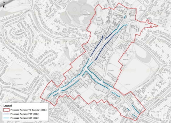
- Amend the Rayleigh town centre boundary, Rayleigh secondary retail & commercial frontage and retain the Area Action Plan (2015) Rayleigh primary retail & commercial frontage, as outlined below in Figure 1.
Rochford:
- Support proposals which address vacant premises and improve the appearance of storefronts that are in need of improvement.
- Continue to recommend the creation of a more vibrant and attractive Market Square.
- Continue to recommend explore opportunities for new and improved town centre pedestrian routes.
- Continue to recommend new and improved public realm, environmental improvements, and junction improvements throughout the town centre.
- Continue to recommend the protection of office-based employment uses in the Locks Hill area.
- Support proposals which advance the development of opportunity sites in Rochford Town Centre. This includes the Spar building; former Police Station; Freight House Car Park; North Street/ Weir Pond Road Junction; West Street/ Union Lane Junction; other key sites (e.g. improving linkages between Roche Close and Market Square.
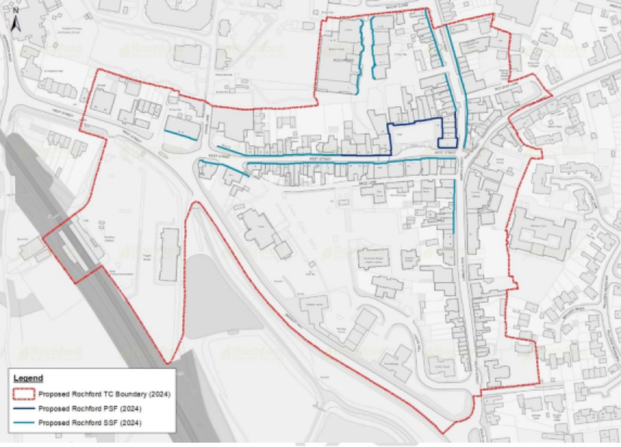
- Amend the Rochford town centre boundary, Rochford primary retail & commercial frontage and Rochford secondary retail & commercial frontage as outlined in Figure 2.
Hockley
- Continue to recommend new and improved public realm and junction improvements throughout the town centre.
- Continue to recommend explore opportunities for new and improved town centre pedestrian routes
- Support proposals which advance the development of opportunity sites in Hockley Town Centre. This includes the Eldon Way Opportunity Area, as identified in the AAP, recommending that the general principles as designated in the AAP should be retained, recognising the potential in the medium-long term for mixed-use development, improved public realm and enhanced pedestrian linkages to support additional employment, retail and leisure opportunities alongside homes in a brownfield location.
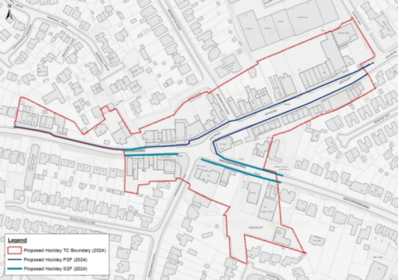
- Retain the Hockley town centre boundary, primary retail & commercial frontage and secondary retail & commercial frontage as outlined in Figure 3:
8.2.7. This Local Plan’s policies therefore seek to ensure the District’s town centres, villages and retail parades to meet the needs of those who live in, work in and visit the District, whilst ensuring that floorspace is flexible enough to respond to new opportunities in future which may be presented by new development, changing consumer habits and technological trends. Whilst it is important to fully maximise the flexibility provided by recent changes in national planning policy, protecting established centres to meet both present and future needs is critical.
Summary of Consultation Feedback
8.2.8. The 2021 Spatial Options consultation feedback conveyed a general sense that market forces and consumer preferences were shifting towards online retail and convenience, and that existing town centres needed to have variety, flexibility and accessibility to attract both new and existing shoppers, and also a greater share of evening and leisure trade. Comments also acknowledged there was a shift to town centres being places for socialising/recreation, and that policies needed to support businesses to adapt and offer new experiences. This could involve the provision of more flexible facilities to enable temporary retail. the conversion of commercial units to residential through permitted development, feeling this would irreversibly change the character of such areas, break up shopping frontages and undermine their role as shopping and community hubs. It was felt that fewer units in retail use would lead to fewer reasons for people to come into town centres.
8.2.9. A couple of comments stressed the importance of also planning for and maintaining village and neighbourhood shopping parades, recognising their crucial role for local communities.
8.2.10. Town centre-specific feedback included the following:
- For Rayleigh, significant feedback was focused on the protection of key community assets such as the Mill Arts and Events Centre. Other feedback revolved around improving pedestrian/cycle access, protecting parking provision, supporting themed markets and additional leisure facilities, and concerns around development in the Conservation Area.
- For Rochford, some sentiment was expressed that the town was declining in relation to Rayleigh, with notable vacant sites. There was support for policies which could encourage more independent businesses, as well as pedestrianising the Market Square. Some responses considered that additional housing growth could help support vitality in the centre.
8.2.11. For Hockley, a few responses identified Hockley as a centre which performs well in meeting everyday needs, although did not feel the Hockley AAP was appropriate in seeking additional large retail or residential uses in the town centre.
8.2.12. ECC’s response recommended the vibrancy of town centres is supported through regeneration efforts, which could consider a wide range of options, for example:
- Seeking a mix of developments (housing, retail, office, leisure).
- Some intensification of housing, optimal use of the land.
- Seeking opportunities for public realm improvement and focal points, pedestrianisation / car free areas, increase in provision of electric vehicle (EV) charging parking spaces, and inclusion of green spaces.
Draft Policy
Policy TC3 - Development in Town Centres and Neighbourhood Parades
Primary and Secondary Retail and Commercial Frontages
- The town centres of Rayleigh, Rochford, and Hockley are identified as key locations for retail, leisure, commercial, cultural and community development. Residential development in a supporting capacity, particularly on upper floors or in peripheral locations away from primary and secondary frontages, will be considered appropriate where they do not undermine town centre uses. Proposals which serve to enhance the public realm of, or sustainable access to, town centres will be supported.
- The updated Primary and Secondary Retail & Commercial Frontages, as identified in the 2024 Town Centre Health Checks report, will guide sustainable development to support vibrant town centre environments with a diverse range of shops, services and amenities. The frontage policies promote flexibility of uses within the town centres, but not at the expense of the loss of the core functions of the town centre, or an over-proliferation of a particular non-town centre use. Proposals in these areas are expected to maintain active frontages at ground floor, or alternative features to avoid blank facades.
- For proposals within or affecting identified Primary Retail & Commercial Frontages, proposals which fall within the NPPF’s definition of main town centre uses, including Class E (retail, offices, restaurants, cafes and gyms), Class F1 (schools, galleries, museums, libraries, public halls, places of worship, and law courts) and F2 (community facilities) will be considered appropriate. Appropriate Sui Generis uses (pubs/bars, hot food take aways, nightclubs, casinos etc) will be supported providing the proposal would:
- entail the provision of a non-Class E use which is considered to positively contribute to the overall offer and encourage people into the town centre.
- not create a cluster of similar non-Class E uses of the same use class within a locality that undermines the commercial character of the town centre;
- not have a detrimental impact on, or undermine, the predominance of Class E and other Main Town Centre uses, both within the town centre as a whole and within the primary retail & commercial frontage
- Class E uses should remain the predominant use at ground level in this area (at least 65%), whilst main town centre uses should constitute a minimum of 85% of units in this area.
- For proposals within or affecting identified Secondary Retail & Commercial Frontages, proposals which fall within the NPPF’s definition of main town centre uses, including Class E, Class F1 and F2 will be considered appropriate. Appropriate Sui Generis uses (pubs/bars, hot food take aways, nightclubs, casinos etc) will be supported providing the proposal would:
- entail the provision of a non-Class E use which is considered to positively contribute to the overall offer and encourage people into the town centre.
- not create a cluster of similar non-Class E uses of the same use class within a locality that undermines the commercial character of the town centre;
- not have a detrimental impact on, or undermine, the predominance of Class E uses, both within the town centre as a whole and within the primary retail & commercial frontage
- Main town centre uses should constitute a minimum of 75% of units in this area.
- Proposals resulting in the loss of main town centre uses at ground floor level to non-centre uses, which results in an unacceptable mix of uses will not be permitted. Proposals resulting in the loss of main town centre uses at ground floor must demonstrate that:
- the use is no longer viable, by evidence of active marketing to the public for at least 12 months, showing that the premises are not reasonably capable of being used or redeveloped for a main town centre use; and
- development would not result in 3 or more adjacent non-centre use units.
The District’s Town Centres
- The existing Town Centre Area Action Plans (AAPs) should continue to be referred to in determining proposals within the town centre boundaries, until the point where replacement strategies, masterplans or SPDs are produced, or where specific aspects are superseded by more recent developments in policy or evidence.
Policies specific to each town centre are dealt with in turn:
Rayleigh
- The Council will support proposals that enhance the status of Rayleigh as the District’s main town centre and market town, supporting a diverse mix of retail and supporting town centre uses, including offices/workspace and evening economy uses. In particular, improvements to public realm; to enhance Rayleigh’s role as a cultural and leisure hub; to facilitate the activities of markets; and to enhance the general accessibility of the centre to all modes of transport (particularly sustainable travel), will be supported. Proposals that meet the broad objectives of the Rayleigh Centre Area Action Plan (or successor) will be supported.
- Much of Rayleigh Town Centre is designated as a Conservation Area, with its commercial role as a historic market town forming a significant aspect of the town’s heritage and identity. Accordingly, the Council will seek to protect ground floor frontages for commercial use, and changes of use to residential under GDPO Class MA will not typically be considered appropriate. Any proposals seeking planning permission to convert a ground floor town centre use to residential will be required to demonstrate:
- the proposal will have no adverse impact on either the vitality of Rayleigh as a commercial centre, or the character of the Conservation Area;
- the use is no longer viable, by evidence of active marketing to the public for at least 12 months, showing that the premises are not reasonably capable of being used or redeveloped for a main town centre use.
Rochford
- The Council will support proposals which seek to enhance Rochford’s role as a historic market town, including the improvement of public realm and pedestrian linkages around the Market Square; enhancement of shopfronts; improved pedestrian links between the Square and Primary/Secondary Retail & Commercial Frontages and surrounding car parks, railway station and open spaces; and improvement of the identified gateway sites (Old Police Station, Freight House Car Park; North Street/ Weir Pond Road Junction; West Street/ Union Lane Junction, Spar Building).
- Much of Rochford Town Centre is designated as a Conservation Area, with its commercial role as a historic market town forming a significant aspect of the town’s heritage and identity. Accordingly, the Council will seek to protect ground floor frontages for commercial use, and changes of use to residential under GDPO Class MA will not typically be considered appropriate. Any proposals seeking planning permission to convert a ground floor town centre use to residential will be required to demonstrate:
- the proposal will have no adverse impact on either the vitality of Rayleigh as a commercial centre, or the character of the Conservation Area;
- the use is no longer viable, by evidence of active marketing to the public for at least 12 months, showing that the premises are not reasonably capable of being used or redeveloped for a main town centre use.
Hockley
- Proposals which serve to enhance the public realm and pedestrian connectivity of Hockley Town Centre will be supported. In particular, this includes enhancements of the areas connecting the town centre with the Railway Station and the Eldon Way Opportunity Area.
- Proposals which serve the broad objectives of the Eldon Way Opportunity Area policy in the Hockley Area Action Plan will be supported, where they seek to improve public realm and accessibility/connectivity and provide compatible mixed uses including retail, leisure, employment and residential.
Neighbourhood/Village Centres and Local Parades
- Proposals should maintain an active ground-floor presence and be of a main town centre use (Class E, F1, F2 or appropriate Sui Generis) unless justified. Single Sui Generis uses (e.g. betting shops or hot food takeaways) should not form more than 40% of the ground floor units in the parade.
- Loss of a unit in these uses will only be permitted where:
- the use is no longer viable, by evidence of active marketing to the public for at least 12 months, showing that the premises are not reasonably capable of being used or redeveloped for a main town centre use; and
- the proposed use provides a community benefit or complements the parade’s role.
Which Strategic Objectives does this policy relate to?
- SO2: Employment and commercial space to help our businesses grow
- SO4: Enabling thriving town centres
- SO9: Community Facilities
- SO10: Protecting and enhancing the historic environment
- SO12: Sustainable patterns of growth
Reasoned Justification
8.2.13. The policy measures related to town centres are in response to the recommendations made in the 2024 Town Centre Health Checks report, and should be read in conjunction with that document for additional detail. This includes detail regarding justification for proposed boundary changes to town centres and primary/secondary frontages, along with key opportunity sites.
8.2.14. The requirements set out in the frontages policies are considered reasonable responses that allow for a considerable degree of flexibility over the previous Local Plan policies, recognising that the nature of town centres has changed considerably since 2011. However, they also seek to ensure key areas of the District’s town centres continue to be retail, food & beverage and other commercial/community uses appropriate to town centres, ensuring that the centres continue to be places to shop, meet, work, access services, eat and socialise. Whilst the Health Checks report notes low vacancy rates, the wider context of high street trends means this position is fragile and vulnerable to changes in the economy, government policy and technological/socio-economic trends.
8.2.15. As part of this, housing is considered to play an important supporting role, adding footfall, demand for town centre uses and activity outside normal working hours. However, this must be balanced with the risk of losing important ground floor commercial space which could be occupied by businesses and services useful to residents, as well as the loss of active frontages (termed ‘dead’ frontages by the Royal Town Planning Institute4), which add breaks into retail areas and reduce footfall to other nearby businesses. Proposals for residential in outlying locations of town centres, as well as upper floors, are considered acceptable. However, those within the frontages at ground level will be subject to strict requirements and will need to be limited in scale and proportion of the frontages they occupy. In addition, regard for NPPF Para. 200 is considered critical, given it states:
“Planning policies and decisions should ensure that new development can be integrated effectively with existing businesses and community facilities (such as places of worship, pubs, music venues and sports clubs). Existing businesses and facilities should not have unreasonable restrictions placed on them as a result of development permitted after they were established. Where the operation of an existing business or community facility could have a significant adverse effect on new development (including changes of use) in its vicinity, the applicant (or ‘agent of change’) should be required to provide suitable mitigation before the development has been completed”.
8.2.16. Given the important role that a number of pubs, nightclubs, event spaces, places of worship and other town centre uses play in town centres, particularly Rayleigh, the Council considers that the onus is placed upon the applicant to demonstrate robustly that their proposal will not lead to future restrictions placed upon town centre uses.
8.2.17. This consultation section includes a supplementary question - 29(a) - to understand whether existing town, village and local centres/parades are sufficient to meet existing and future needs of the communities they serve. This reflects both the growth in a range of village and suburban areas in the previous Plan period, as well as the potential for further future growth.
Have Your Say…
Policy TC4 – Night-Time Economy
Context and Background
8.2.18. This policy seeks to encourage a vibrant and diverse night-time economy across Rochford District’s town centres while ensuring that potential impacts on residents, heritage, and the environment are carefully managed. It recognises that the district’s centres, particularly Rayleigh, have a strong offering in terms of restaurants, pubs, cafes and entertainment venues, whilst there are opportunities for further growth to positively enhance the local economy.
8.2.19. It draws on evidence from the Town Centre Health Checks 2023/24, as well as the NPPF.
Summary of Consultation Feedback
8.2.20. Feedback considered existing town centres needed to have variety, flexibility and accessibility to attract both new and existing shoppers, and also a greater share of evening and leisure trade. Comments also acknowledged there was a shift to town centres being places for socialising/recreation, and that policies needed to support businesses to adapt and offer new experiences. The importance of pubs to rural communities and as places to meet and socialise was highlighted.
Draft Policy
Policy TC4 - Night-Time Economy
Encouraging Economic Growth and Vitality
- The Council will support proposals that contribute to a diverse evening and night-time offer in Rayleigh, Rochford, and Hockley town centres, including restaurants, pubs, cafés, cultural venues, and leisure activities. Within defined town centre boundaries, proposals for evening economy uses—including restaurants, cafés, cultural venues, leisure facilities, and appropriately managed pubs/bars—will be supported where they:
- Contribute positively to the centre’s vitality and diversity;
- Do not result in an over-concentration of late-night uses that harm amenity or character.
Location and Clustering
- Evening economy uses should be located within primary and secondary shopping frontages or other active town centre streets, away from predominantly residential areas. Proposals that would create more than three consecutive units of late-night uses (sui generis pubs/bars/takeaways) will be resisted unless an impact assessment demonstrates no harm to amenity, safety, or the centre’s retail/service function.
Managing Impacts on Residents and the Environment
- Development must incorporate the Agent of Change principle (as per NPPF para. 200), ensuring that new residential or sensitive uses near existing night-time venues are designed to mitigate potential noise and disturbance. Proposals for night-time uses must include measures to manage:
- Noise and vibration (through soundproofing, layout, and operational management).
- Public safety and perceptions of safety, including adequate lighting, CCTV, and active frontages.
- Transport and accessibility, ensuring safe evening travel options and integration with public transport.
- Environmental quality, including waste management, litter control, and minimising anti-social behaviour.
Hours of Operation
- Conditions may restrict hours of operation where necessary to protect residential amenity, particularly in areas with a high proportion of housing.
Which Strategic Objectives does this policy relate to?
- SO2: Employment and commercial space to help our businesses grow
- SO4: Enabling thriving town centres
- SO9: Community Facilities
- SO12: Sustainable patterns of growth
Reasoned Justification
8.2.21. The policy measures related to town centres are in response to the recommendations made in the 2024 Town Centre Health Checks report, and should be read in conjunction with that document.
8.2.22. The evening economy plays a vital role in sustaining town centre vitality, supporting linked trips, and diversifying uses beyond traditional retail. The Health Checks evidence shows that food, drink, and leisure uses have grown in importance for resilience, and that cultural and leisure uses (such as live music venues, theatres, and community spaces) contribute to the distinct identity of each centre and enhance social cohesion. However, unmanaged clustering of late-night uses can lead to noise, anti-social behaviour, and loss of daytime retail function.
8.2.23. The National Planning Policy Framework (NPPF) requires local plans to promote town centre vitality, encourage diversification, and apply the Agent of Change principle. This ensures that new residential development near existing venues must incorporate appropriate mitigation measures, protecting established businesses from future conflict.
8.2.24. Policy TC4 therefore seeks to strike a balance, on the one hand, encouraging investment in restaurants, cafés, pubs, and cultural venues to support economic growth and create vibrant centres. On the other, requiring applicants to demonstrate how they will manage impacts on residents, public safety, and environmental quality.
8.2.25. Monitoring indicators will include the distribution of evening economy uses, vacancy rates, and amenity-related complaints, reported through the Authority Monitoring Report.
Have Your Say…
Policy TC5 – Shops and Public Houses in Rural Areas
Context and Background
8.2.26. Rural pubs and shops are more than commercial enterprises: they are social anchors that sustain community life, reduce isolation, and provide essential services in villages and hamlets across Rochford District. Evidence from national studies and local engagement highlights that once such facilities are lost, they are rarely replaced, leading to long-term impacts on community cohesion and rural sustainability.
Summary of Consultation Feedback
8.2.27. Consultation feedback considered the need to preserve local village amenities, such as shops, pubs and community centres, to be vital, recognising that the loss of these places is disruptive to local community cohesion and wellbeing. There were some views that development in rural areas and villages could help provide additional footfall land support to such venues, however it also represents a threat as such amenities could risk being redeveloped themselves. In addition, it was felt that if villages lost their rural character, this could affect the unique selling points of some pubs. Feedback also felt that pubs could be utilised more widely to provide services and meeting environments for local communities, beyond providing food and drink.
Draft Policy
Policy TC5 - Shops and Public Houses in Rural Areas
Safeguarding existing facilities
- The Council will resist the loss of rural pubs, shops, and other small-scale community services that are located in rural areas, or settlements constituting ‘villages’ (i.e. below Tier 2 in the Settlement Hierarchy) unless:
- It can be demonstrated through robust evidence that the use is no longer viable, and all reasonable efforts to retain or market the facility for community use have been exhausted; or
- Equivalent or better provision is made elsewhere within the same rural settlement.
- In assessing proposals for the loss of a public house, applicants must provide evidence consistent with CAMRA’s “Public House Viability Test”, including but not limited to:
- Demonstrating sustained marketing of the pub as a going concern for at least 12 months at a realistic price.
- Evidence of engagement with the local community and consideration of alternative business models (e.g., diversification, community ownership).
- Financial accounts showing viability issues, alongside evidence that reasonable operational changes have been explored.
Supporting Enhancement and Diversification
- Proposals that seek to enhance the viability of rural pubs and shops, including diversification into complementary uses (such as cafés, post office counters, community meeting spaces, or local produce sales), will be supported where they do not harm residential amenity or the rural character of the area.
New Development and Agent of Change
- New residential or sensitive uses proposed adjacent to rural pubs or shops must incorporate the Agent of Change principle (as per NPPF Para. 200), ensuring that existing businesses are not adversely affected by future noise or activity complaints.
Which Strategic Objectives does this policy relate to?
- SO2: Employment and commercial space to help our businesses grow
- SO3: Supporting Rural Diversification
- SO9: Community Facilities
- SO12: Sustainable patterns of growth
Reasoned Justification
8.2.28. Rural pubs and shops are vital community hubs, providing social, cultural, and economic value far beyond their commercial role. Once lost, they are rarely replaced, leading to long-term impacts on community cohesion and rural sustainability. The Town Centre Health Checks (2023/24) highlight the importance of local services in sustaining smaller settlements and reducing rural isolation.
8.2.29. The National Planning Policy Framework (NPPF) requires planning authorities to guard against the unnecessary loss of valued facilities and services. To ensure that any proposed loss of a pub is rigorously tested, Rochford District Council will apply CAMRA’s Public House Viability Test. This nationally recognised framework ensures that closure or change of use is only permitted where there is clear and transparent evidence of non-viability, including proper marketing, financial assessment, and exploration of alternative models such as community ownership.
8.2.30. By embedding CAMRA guidance into local policy, the Council ensures that decisions are robust, evidence-based, and defensible at appeal, while safeguarding the distinctive character and social fabric of Rochford’s rural communities.
8.2.31. The Council’s Strategic Planning and Economic Development teams have supported past efforts, both successful and unsuccessful to retain village pubs and prevent their loss to other uses, with this having fed into the approach to this policy. The Public House Viability Test has proven a useful source in these responses, having been developed by industry experts.
Have Your Say…
9. Homes for a Growing Community
9.1. Housing Choice and Affordability
Strategic Policy H1 – Housing Mix
Policy Context & Background
9.1.1. It is important that housing delivered in the Local Plan meets the needs of our local residents and leads to the creation of mixed and balanced communities. The NPPF is also clear on this point, that we should meet the needs of all our residents including those that require affordable housing, families with children, looked after children, older people, students, people with disabilities, service families, travellers, people who rent their homes and people wishing to commission or build their own homes. We do this by providing sufficient good quality housing of the right types, mix, sizes and tenure in sustainable locations within Rochford.
9.1.2. The South Essex Housing Needs Assessment (SEHNA) 2022 is the key evidence base document for the consideration of housing in the Rochford Local Plan and was commissioned by all south Essex authorities (Basildon, Brentwood, Castle Point, Rochford, Southend and Thurrock) in 2021. Whilst the overall housing requirements set by government have changed dramatically since that time, with the introduction of the new way of calculating housing requirements in 2024, the findings within it relating to specialist housing accommodation, housing size and mix remain valid.
9.1.3. In terms of housing type and size, there is a clear requirement for houses with that representing 71% of the need in Rochford, 21% bungalows and 9% flats. Size wise 6% 1 beds, 22% 2 beds, 43% 3 beds and 4 or more beds 29% is the mix identified within the study.
9.1.4. The study also shows the aging population across all of South Essex, including Rochford and that this will need to be accounted for within the housing provided, through the provision of specialist housing but also through ensuring market housing is flexible and adaptable, and available in different sizes, as most older people remain in private housing.
9.1.5. Around 1 in every 6 residents surveyed said that they had a disability which limits their abilities to at least some extent. This figure substantially increases with age. Most of these people live in private accommodation which highlights the need again for homes to be flexible.
9.1.6. Turning to students there are over 4,000 students over 16years old in Rochford, however only 25 student properties. This together with the lack of a local university indicates that most students are likely to be living at home with parents. This does not indicate a need to specifically plan for student accommodation.
9.1.7. The Council maintains a Self and Custom Build register for people who wish to build a property in the District. Provision should therefore be made for opportunities for self and custom builders on this list.
Summary of Consultation Feedback
9.1.8. A broad mix of comments were made in the 2021 consultation on the different types, sizes and tenures of housing considered to be needed in the District, and how best to plan for these. ECC indicated that reference should be made to ECC’s Essex Housing Strategy 2021-2025 (2021). Developers /agents commented that consideration should be given to the demographics of the District with flexibility designed into policy ensuring viability.
9.1.9. Many comments also indicated that development for housing should only be for specific types, such as inclusive and accessible specialist homes, or affordable housing. There was a preference for this type of housing for new developments on both brownfield sites in urban areas and released Green Belt. It was indicated that affordable homes should be provided on site, and for local people. Comments supported the idea that specific sites should be allocated for housing for older people, avoiding competition with general market housing developers, and that infrastructure needs should be considered. Smaller developments were seen by many as being more beneficial.
Draft Strategic Policy
Strategic Policy H1 – Housing Mix
- All new residential development should deliver an inclusive, accessible environment to meet the needs of our communities.
- On development proposals of 10 or more additional dwellings the Council will require;
- An appropriate mix of dwelling types, sizes and tenures to meet the identified housing needs in the District, as set out in the Council’s most up to date housing need evidence, to provide choice and contribute towards the creation of sustainable, balanced and inclusive communities; and
- Each dwelling constructed to meet requirement M4(2) accessible and adaptable dwellings, as a minimum, of the Building Regulations 2015, or subsequent equivalent standard.
- On developments of 60 or more dwellings, the Council will additionally require;
- A minimum of 5% new affordable dwellings should be built to meet requirement M4(3) wheelchair accessible dwellings of the Building Regulations 2015, or subsequent equivalent standard.
- A minimum of 5% new affordable dwellings should be built to meet requirement M4(3) wheelchair accessible dwellings of the Building Regulations 2015, or subsequent equivalent standard.
- On developments of 100 or more dwellings the Council will additionally require;
- a minimum of 5% self-build homes which can include custom housebuilding provided there is a need as justified within the Council’s most up to date evidence; and
- provision for other forms of Specialist Accommodation taking account of local needs.
- Where a development site has been divided into parts, or is being delivered in phases, the area to be used for determining whether this policy applies will be the whole original site.
- The inclusion of self-build and custom build homes and specialist accommodation on smaller sites will also be encouraged.
Which Strategic Objectives does this policy relate to?
- SO1: Housing to meet Local needs
- SO13: Ensuring High Quality design
Reasoned Justification
9.1.10. It is important, and a requirement of the NPPF, that the Council provides for a mix of housing based on current and future demographic and market trends to meet the needs of all different groups in the community. This policy aims to meet those needs whilst also recognising that these will need to be fully tested through the viability report when taken together with all other policies in the Plan.
9.1.11. The South Essex Strategic Housing Needs Assessment 2022 indicates the need for size of properties in the District as set out below. This may be superseded by more recent studies during the lifetime of this Plan and should be updated accordingly. Sites should reflect this mix in the vast majority of cases, although on some sites such as a town centre regeneration area, a different mix may be appropriate. This should be discussed with the planning team at the earliest opportunity.
Table 7: Indicative dwelling mix
|
Dwelling Size |
Indicative Mix |
|
1 bedroom |
6% |
|
2 bedroom |
22% |
|
3 bedroom |
43% |
|
4 + bedroom |
29% |
Source: Rochford District Council (2025)
9.1.12. As well as size, a range of style of properties should also be provided, especially on larger sites, both in design terms but also flats, homes, bungalows etc. This gives the maximum amount of choice for future residents. The evidence base also clearly reflects a need for homes which are flexible and adaptable and as such this policy proposes that all dwellings should be built to adaptable standards. The tenure mix of homes is set out within Policy H2 Affordable Housing.
9.1.13. In order to deliver mixed communities we are requiring that larger sites include not only the mix of house types but also elements of specialist housing and wheelchair accessible units. This will ensure the site incorporates a range of people and can offer flexibility as the community ages for example, or has changing circumstances.
9.1.14. If any applicant is seeking to change the mixes in the policy for the reasons set out above, the Council will expect this to be justified in the most robust terms including for example viability, demographic or site-specific information. The Council may require its own independent assessment of the information submitted which will be done at the cost of the applicant.
9.1.15. Conditions may be used to ensure house types or tenures remain available in perpetuity.
Have Your Say…
Policy H2 – Affordable Housing
Context & Background
9.1.16. NPPF Paragraphs 63 - 68
9.1.17. Rochford has very high levels of home ownership compared to national averages and corresponding lower levels of social rent and private rent. As such it is important that we ensure local residents can get on the housing market by delivering a range of affordable housing purchase and rental properties within the new Local Plan. This allows local families to grow, live and work locally.
9.1.18. The South Essex Housing Needs Assessment was completed by consultants in 2022 and considers housing needs across Brentwood, Basildon, Castle Point, Thurrock and Southend, as well as Rochford. It concludes that 55% of people cannot afford to buy a property in Rochford and 29% are unable to afford to rent (based on average sales price and average incomes) and that taking the committed supply (at that time) plus the turnover of homes already in the system, there is a need for 248 new affordable homes per year. Provision of affordable housing is a key part of the costs associated with a development and this has been tested within the Local Plan Viability Assessment which can be found in the evidence base.
Summary of Consultation Feedback
9.1.19. In the 2021 consultation there was a preference for affordable housing for new developments on both brownfield sites in urban areas and released Green Belt. It was indicated that affordable houses need to be calculated for a given period to avoid lengthy negotiations, and that affordable homes should be provided on site, and for local people.
Draft Policy
Policy H2 – Affordable Housing
- All residential developments of 10 or more (net) dwellings will be required to provide affordable housing.
- On sites which have been released from the greenbelt in this Plan or sites not allocated but within the greenbelt, 50% of the homes should be affordable housing. However, greenbelt sites in the low value zone which are less than 50 homes should deliver at least 35% affordable homes.
- On greenfield sites (which are not designated greenbelt), at least 35% affordable housing should be delivered.
- On brownfield sites within the high value zone sites of 50 or more should deliver at least 25% affordable housing and sites of less than 50 should deliver at least 10% affordable housing.
- Brownfield sites within the low value zone should deliver the maximum affordable housing which is viable, based on an individual assessment.
- In considering proposals for affordable housing, the Council will require that:
- Any affordable housing provides a tenure split of 60% affordable rent; 25% first homes and 15% intermediate housing unless an alternative split is agreed with the Council's Housing team;
- Any affordable housing to be delivered on a development also delivering market housing shall be seamlessly integrated into the layout of that development;
- The mix of affordable housing in terms of size and type of dwelling reflects the Council's latest housing needs evidence;
- The affordable housing will be provided on-site, unless it can be clearly demonstrated that on-site provision is not achievable in exceptional circumstances. In such cases, the Council will require appropriate off-site provision to be secured, or a financial contribution in lieu of on-site provision made which covers all costs necessary to deliver the commensurate number of affordable homes on another site.
- In seeking affordable housing provision, the Council will have regard to the viability of individual developments. Where robust and objective viability evidence demonstrates that compliance with this policy cannot be achieved, the Council will expect the highest level of viable compliance to be achieved.
- Where a site has been sub-divided and/or different parts of a site have been brought forward separately, yet the total site would cater for 10 or more (net) dwellings, the Council will still apply this policy as it would had the site come forward as a single development.
- Planning obligations will be used to ensure that affordable housing remains at an affordable price for future eligible households, or for the subsidy to be recycled to alternative affordable housing provision.
- The Council will use planning obligations to ensure it has nomination rights over any new affordable homes delivered in the District.
- The requirement to provide affordable housing will apply to all residential development falling under Use Class C3, or any successor class, except for Gypsy and Traveller pitches.
Which Strategic Objectives does this policy relate to?
- SO1: Housing to meet Local Needs
- SO12: Sustainable patterns of growth
Reasoned Justification
9.1.20. National government guidance requires that Local Plans have policies in place to ensure that affordable housing is delivered as part of the Local Plan. The evidence base includes an assessed need for 248 new affordable homes per year of all types. This is just over 1/3 of the government required target with the 5% buffer added. Whilst there is a mix of levels of affordable housing on different size and type of sites due to viability issues, it is considered that overall this policy will deliver on that affordable housing need for a mixture of home ownership and rental properties.
9.1.21. The NPPF includes new ‘Golden Rules’. These require that new housing development which is built on greenbelt land, or land which has been released from the greenbelt through a local plan, should deliver at least 50% and deliver a greater level of affordable housing than other sites, if it is viable to do so.
9.1.22. The Viability study considers all the policies in the Plan taken together and considers whether these can be delivered in a viable way. The delivery of affordable housing is one of the biggest impacts on viability. The study has identified that there are different housing market value zones in the District, a high value zone which includes Rayleigh, Hockley and Hullbridge in the west of the District, and a lower value area in the middle and east of the District including Rochford and Great Wakering. The zones are set out in Figure 4 below.
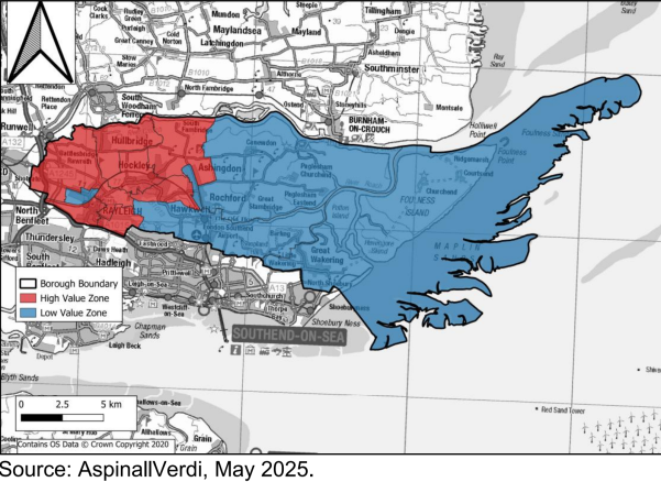
9.1.23. The viability review indicates that those smaller sites in the Green Belt low value zone, cannot viably deliver this level of affordable homes, and 35% is therefore proposed. This will be kept under review as the Plan progresses.
9.1.24. Brownfield sites are sites which have already been developed, they usually have extra costs associated with demolishing, clearing and decontaminating which makes them less viable for development. However, they are often located in our towns and villages, in some of the most sustainable locations, making them suitable sites for redevelopment. The viability study indicates that brownfield sites in the higher value zone will be able to deliver some affordable housing, depending on the size of the site, but that those in the lower value zone are unlikely to be able to deliver any affordable housing. This is based on the average typologies, but there may be individual circumstances where some affordable housing will be possible. As such all brownfield sites in the lower value zone should be accompanied by a site specific viability assessment to accompany any planning application, and the maximum amount of affordable housing will be secured up to the higher value zone levels.
9.1.25. In exceptional circumstances, the Council will consider whether it will take a contribution towards affordable housing, rather than the delivery of affordable housing on the site. This is not the preferred option and will only be considered where a detailed viability analysis concludes it is not possible to deliver on site and this will be independently verified by the Councils experts, at the cost of the applicant.
9.1.26. The policy also includes the expected tenure levels of affordable housing, which includes affordable rented housing and home ownership options. This is the baseline position and expected to be achieved for most sites. However, it is recognised that some sites may be better placed to deliver a different mix of affordable housing. Early discussions with the housing team will be necessary to see if a different mix is acceptable. The mix of sizes of properties should also be agreed with the housing team on a case-by-case basis reflecting the current housing waiting list and site context.
9.1.27. Housing design should be tenure blind and as such affordable housing should be indistinguishable from market housing in a development. The affordable housing should not be clustered but should be located throughout the development.
9.1.28. This policy applies to all sites which can accommodate 10 or more homes. If the Council thinks that sites have been artificially severed and come forward in separate applications, but which will amount to more than 10 homes, than the usual affordable housing requirements as set out in the policy, will apply.
9.1.29. Taking all this into account therefore at this stage we consider that the percentages set out in the above policy will provide the maximum affordable housing which can be delivered in the Plan. However, this will continue to be kept under review as further evidence base work is completed so that the maximum levels of affordable housing can be achieved.
Have Your Say…
Policy H3 – Protecting Existing Housing Stock
Context & Background
9.1.30. No specific reference in the NPPF, but general references to different housing types in paragraphs 61 - 63
9.1.31. Houses in Multiple Occupation (HMOs) are not historically common in Rochford District but there have been some recent applications concentrated in the bigger towns. Whilst HMOs can provide a good source of low cost housing and flexible living arrangements, this must be balanced with potential issues associated with high density living.
9.1.32. There is no specific evidence base on HMO’s.
Summary of Consultation Feedback
9.1.33. This is a new policy area and as such there was no relevant feedback in the previous consultation. It is proposed to be included following on a number of recent planning applications for Houses of Multiple Occupation.
Draft Policy
Policy H3 – Houses of Multiple Occupation
- All proposals for the conversion, construction or intensification of Houses of Multiple Occupation (HMO) must meet all the following criteria;
- The development will not result in an over concentration of HMOs that would harm the character of the surrounding area or have an unacceptable impact on neighbouring amenity;
- Sufficient off-street car parking and cycle parking must be provided in accordance with the Essex Parking Standards (or subsequent documents);
- Sufficient space for waste and recycling storage and collection must be provided within the property boundary; and
- The HMO must provide a high standard of living for future occupants, ensuring adequate room sizes, sufficient kitchen and bathroom facilities and access to an area of outdoor amenity space.
Which Strategic Objectives does this policy relate to?
- SO1: Housing to meet Local Needs
- SO12: Sustainable patterns of growth
Reasoned Justification
9.1.34. HMOs have benefits in providing low cost and flexible housing, often utilised by young professionals. As facilities are shared costs can be lower, providing a more affordable option for renting. They are also often available on shorter leases and are therefore more flexible for those working on short-term contracts. They are often found in large concentrations near hospitals and universities and whilst Rochford district does not have a large number of HMOs, the high rental prices and limited private rental stock means that urban areas in Rochford District may be attractive to HMO developers.
9.1.35. This policy is considered appropriate to manage the implications of HMOs which result from the more intensive use of a property. This includes ensuring that waste storage, car and cycle parking are adequately provided, alongside appropriate management of any other issues associated with noise and amenity, to limit the impact on the local area.
9.1.36. The policy requires that there should be no over concentration of HMOs in a single area. This is not absolutely definition and this will be a matter of judgement on a case-by-case basis, considering the properties involved and the prevailing characteristics of the local area.
Have Your Say…
9.2. Specialist and Diverse Housing Needs
Policy H4 – Specialist Housing
Policy Context
9.2.1. NPPF paragraphs 61 -63
9.2.2. Rochford has an older age profile than many authorities, with a median age of 46 compared to 40 nationally. The 2021 census showed that 23.9% of our population is over 65. As such providing appropriate housing for older people, will be a particular challenge for the District, as well as other types of specialist housing.
9.2.3. The SEHNA anticipates a continued aging population with a 35% increase in over 65s, 49% increase in over 75s and 59% increase in over 85s in Rochford District. Many of these people continue to live in open market housing, but there is a suggested need for small numbers of specialist housing provision.
9.2.4. The SEHNA also indicates that 10% of the District population is limited a little by living with a disability and 7% are limited a lot, meaning adaptable housing as well as specialist housing will be important.
9.2.5. Recently completed for Essex County Council, the Supported and Specialist Housing and Accommodation Needs Assessment sets out needs for different specialist uses across Essex and broken down by District. Whilst there are very small numbers for other specialist accommodation identified, it shows there is significant need for a variety of older persons housing in both market and affordable options and those that are wheelchair accessible.
Summary of Consultation Feedback
9.2.6. Many residents supported the provision of specialist housing and advocated for sites specifically allocated for this use to avoid competition with the market. Hullbridge was mentioned as a place that would benefit from additional sheltered housing style accommodation. Developers and agents wanted consideration of the demographics of the District and wished for flexibility in policies to ensure viability
Draft Policy
Policy H4 – Specialist Housing
- Proposals for specialist accommodation, including types or tenures specifically designed for older people or people with disabilities, will be supported provided that all the following are met:
- the development meets an identified local need for such accommodation;
- the development would be sited close to existing facilities and services such that the day-to-day needs of those residing in such accommodation could easily be met;
- the development is well-located with respect to public transport;
- the development would be well-integrated with the surrounding area such that it would not lead to social isolation;
- the development would not lead to an excessive proliferation of similar accommodation in a locality in a way that is harmful to inclusivity or social integration; and
- local health facilities can accommodate the needs of the residents of specialist accommodation.
- Where developments of specialist accommodation would fall within the Use Class C3, or any successor class, the requirements of Policy H4 in relation to affordable housing would still apply
- Planning obligations may be used, where appropriate, to restrict occupation of such accommodation for those with a demonstrable need for the accommodation.
Which Strategic Objectives does this policy relate to?
- SO1: Housing to meet Local Needs
- SO12: Sustainable patterns of growth
Reasoned Justification
9.2.7. The NPPF requires Rochford to meet the housing need of different groups in the community. The evidence base shows that Rochford has an aging population and as such should plan appropriately for a range of specialist housing to meet those needs, as well as the specialist needs of other groups. These should be in adaptable, market, affordable and specialist options.
9.2.8. This policy proposes a number of criteria that proposals for specialist housing should meet to ensure it is successful. These include locating it close to existing facilities and public transport links for residents which may be less able to access private transport and ensuring that there is not an over provision of the same type of accommodation which could lead to impacts on character and amenity of the local area and impact on local healthcare provision.
9.2.9. As this Local Plan progresses, there may be sites that we would allocate for specialist housing types only, or as part of a wider site which can accommodate a range of housing types.
Have Your Say…
Policy H5 – Gypsy and Traveller Accommodation
Context & Background
9.2.10. NPPF paragraph 63 and Planning Policy for Travellers sites
9.2.11. There are currently 41 pitches on 21 sites for Gypsy and Travellers in the District. Most have permanent permission, although 4 sites totalling 14 pitches were unauthorised as of December 2025. Across South Essex there is a high need for this type of accommodation and significant unmet needs from neighbouring authorities.
9.2.12. The Gypsy and Traveller Accommodation Assessment (GTAA) was commissioned across Essex but with an individual report created for each authority. The assessment concludes that there is a need for 65 new gypsy and traveller pitches in Rochford by 2042, the majority of which (37) are needed before 2028. There is no requirement for places for travelling showpeople.
Summary of Consultation Feedback
9.2.13. Comments on the previous consultation were mixed with appropriate sites needing to be identified, outside of urban areas. Comments presented some support for both a permanent and transit site, if required. A joint local authority approach was advocated. Comments said that criteria-based policy for Gypsy and Traveller sites should include community engagement, location – access to employment, public transport and community infrastructure, exclude Green Belt land, avoid sites on or near Source Protection Zones, contaminated land and refuse tips, floodplains, protected areas / designations, and those of special landscape character.
Draft Policy
Policy H5: Gypsy and Traveller Accommodation
- Proposals for new pitches or plots for Gypsy, Traveller and Travelling Showpeople households will be supported provided that:
- the site is well related to existing communities and accessible to local services and facilities, such as shops, primary and secondary schools, healthcare and public transport;
- a safe and convenient vehicular access to the local highway network can be provided;
- essential services, including water, electricity and foul drainage, are available or will be made available on the site;
- there is no significant adverse impact on the intrinsic character and beauty of the countryside;
- the development would not lead to the loss of, or adverse impact on, important historic and natural environment assets;
- there is no significant risk of land contamination;
- there is no unacceptable risk of flooding;
- the site would provide suitable living accommodation for the proposed residents and would not give rise to a significant adverse impact on the amenity of neighbouring residents;
- the site is of a sufficient size to accommodate the proposed number of caravans, vehicles and ancillary areas;
- where commercial uses are present on the site, these would be designed so as not to cause detriment to the safety or wellbeing of the proposed residents; and
- where relevant, sufficient space is available for the storage, repair and maintenance of equipment.
- The sub-division of authorised Gypsy, Traveller and Travelling Showpeople sites will be supported provided that:
- the site is of a sufficient size to enable the creation of additional pitches or plots whilst preserving living conditions for all occupants;
- there is no significant adverse impact on the intrinsic character and beauty of the countryside;
- the sub-division would not result in a significant loss of soft or hard landscaping and / or amenity provision within the existing site;
- the sub-division would not give rise to a significant adverse impact on the amenity of neighbouring residents;
- any increase in vehicular traffic that would result from the sub-division does not give rise to an adverse impact on highway safety;
- where commercial uses are present on the site, these would not cause detriment to the safety or wellbeing of the proposed residents; and
- where relevant, sufficient space remains available for the storage, repair and maintenance of equipment.
- Where new pitches or plots would fall within the Green Belt, including those resulting from sub-division, permission will only be granted in very special circumstances having regard to the characteristics of a proposal.
- Development which would redevelop authorised Gypsy, Traveller and Travelling Showpeople sites for alternative uses will only be considered acceptable where it can be demonstrated that the site is unsuitable to remain in its authorised use, or where replacement accommodation is to be provided and that replacement accommodation is acceptable under parts A or B of this policy.
Which Strategic Objectives does this policy relate to?
- SO1: Housing to meet Local Needs
- SO12: Sustainable patterns of growth
Reasoned Justification
9.2.14. The evidence base shows that there is a need for this type of accommodation within the District, and government guidance is, it is expected to be met. The above policy therefore provides a range of criteria upon which both allocations and speculative planning applications will be judged upon. These criteria are to ensure that there are appropriate and safe living conditions for the residents of the sites and that there is no significant adverse impact on the intrinsic character and beauty of the countryside.
9.2.15. Because of the need for new Gypsy and Traveller sites, the policy is also supportive of the subdivision of existing sites, where there is sufficient capacity and protection for all sites to preserve the numbers we already have.
9.2.16. As well as the criteria based policy, it may be necessary to allocate specific sites within the Local Plan for Gypsy and Traveller pitches. These may be sites specifically for this use or part of as part of a wider site that can accommodate a range of housing types.
9.2.17. Prior to November 2025, only 4 sites had been submitted for consideration for Gypsy & Traveller use, with 3 of these also indicating they are available for other uses (such as residential housing). Further analysis is required to assess both the suitability of these sites and whether alternative approaches are also required. These include identifying additional sites through the ongoing Call for Sites process; working with existing known unauthorised sites to identify opportunities to regularise these through the development management process; considering whether larger-scale or strategic sites have scope to include an element of Gypsy & Traveller-appropriate land; or considering whether any cross-boundary engagement work is required with neighbouring local authorities to identify a solution to meet mutual needs.
9.2.18. Additional work will need to be undertaken prior to Regulation 19 to consider the options available in terms of sites, which is dependent on the outcome of this Regulation 18 consultation. This could be presented in a topic paper.
Have Your Say…
Policy H6 – Residential Annexes
Context & Background
9.2.19. No specific references in the NPPF
9.2.20. Planning applications for residential annexes are submitted regularly in Rochford and therefore a specific policy is proposed on which those applications can be judged.
9.2.21. There is no specific evidence base associated with residential annexes. However, in some cases they can provide specialist accommodation for older family members or those with specific needs which would meet some needs identified in the SEHNA
Summary of Consultation Feedback
9.2.22. There was no specific consultation feedback on residential annexes within the 2021 spatial options consultation.
Draft Policy
Policy H6 – Residential Annexes
- Proposals to create residential annexes within the curtilage of an existing dwelling will be supported provided that the development would meet all the following criteria:
- be ancillary and subordinate in scale, size and function to the main dwelling;
- have a functional tie to the main dwelling and would not constitute the creation of a new dwelling in its own right;
- not result in an adverse impact to the amenity of neighbouring residents; and
- not result in the loss of private amenity space to the main dwelling below the requirement for that dwelling as set out in Policy D3.
- Proposals for residential annexes outside of the curtilage of an existing dwelling will generally be considered to form a new dwelling and will be considered under the relevant policy.
Which Strategic Objectives does this policy relate to?
- SO1: Housing to meet Local Needs
- SO12: Sustainable patterns of growth
Reasoned Justification
9.2.23. Residential annexes are buildings which are located within the curtilage (usually defined as the garden area around a property). Some annexes are attached to the main property, but many are separate buildings. To be considered an annexe rather than a new property, the annexe should be linked to the main property, for example with shared garden, access and parking spaces, and use of the some of the internal facilities of the main house.
9.2.24. They should also be of a significantly smaller scale to the main house and be designed and use materials which recognise this fact and are appropriate to the character of the host property and local area. This will be even more important if the host or neighbouring buildings are listed, or in a conservation area.
9.2.25. Annexes are often occupied by relatives of those in the main house and planning conditions will be applied to ensure that the annexe continues to be used as ancillary to the main dwelling. In some circumstances the Council may consider linking the planning permission to specific personal circumstances.
Have Your Say…
Policy H7 – Houseboats
Context & Background
9.2.26. There are no specific references to houseboats within the NPPF
9.2.27. With significant river environments in the District, there are opportunities for a range of uses, including navigation, leisure and living. As such a policy on houseboats is appropriate.
9.2.28. There is no specific evidence base in relation to houseboats.
Summary of Consultation Feedback
9.2.29. There were no specific comments in the 2021 consultation on houseboats.
Draft Policy
Policy H7 – Houseboats
- Proposals to permanently moor houseboats, including any development associated with the mooring of houseboats, will only be supported where:
- there would be no adverse impact on nature conservation or biodiversity interests, including any sites protected for the purposes of species or habitats;
- there would be no material harm to the character or openness of the Green Belt;
- there would be no significant adverse impact on local character or desirable landscapes; and
- the mooring does not conflict with activity, privacy and amenity of neighbouring uses.
- Where permission is granted for the mooring of houseboats, the Council may use planning obligations to require the removal and disposal of any vessel so moored if it is subsequently becomes uninhabited, sinks, becomes unfit for habitation or is otherwise abandoned.
Which Strategic Objectives does this policy relate to?
- SO1: Housing to meet Local Needs
- SO12: Sustainable patterns of growth
Reasoned Justification
9.2.30. For the purposes of this policy, a “houseboat” is a boat which is not primarily used for navigation, and is kept on a river or its estuaries, creeks and tributaries, or other natural or man-made waterways such as lakes, long term for residential use. Houseboats require planning permission.
9.2.31. The Rivers Crouch and Roach and their estuaries, creeks and tributaries are ecologically important environs which encompass some of the most sensitive habitats within Rochford District. They are therefore a valuable environment of ecological significance, which the Council will protect from any undue disturbance or pollution. The presence of houseboats has the potential to have a negative impact on these sensitive environments.
9.2.32. Houseboats which have permanent moorings are considered to be a form of residential development within the District, because the occupation of such dwellings would require the implementation of infrastructure necessary for the continuance of occupation. Not only that which is associated with traditional permanent housing, including pedestrian and vehicle access roads, car parks and toilets, but also fuel stores, jetties and access structures. Such development would not only impact on the wildlife and the nature conservation importance of the Rivers but may be considered unsustainable development which would not be able to access services by walking, cycling or public transport.
9.2.33. The rivers in the District are used for both commercial and leisure purposes. It is important that the right of navigation on the rivers for both leisure and commercial users is protected. Whilst this is not directly a matter for the Local Planning Authority, it is nevertheless important that development (including houseboats) does not impede the safe and efficient navigation of the rivers. The Local Planning Authority will consult the Crouch Harbour Authority on applications for houseboats. Applicants for houseboats should be mindful that, in addition to planning permission, all vessels used for residential purposes within the harbour (which includes marinas, boatyards, creeks, mud berths etc.) are required by Crouch Harbour Act 1974 to be licensed by Crouch Harbour Authority, who have other licencing and enforcement powers.
9.2.34. Disused houseboats, where a past residential use has been abandoned, have the potential to be of significant detriment to the visual amenity of the locality. Where planning permission is granted for the mooring of houseboats, the Council will require the applicant to enter into a legal agreement for the removal and disposal of any vessel so moored if it subsequently sinks, or becomes unfit for habitation, derelict or is otherwise abandoned.
Have Your Say…
10. The Historic Environment
10.1. Heritage and Local Character
HE1: Conservation and Enhancement of Historic Environment
Context and Background
10.1.1. The National Planning Policy Framework (NPPF) requires local planning authorities to conserve heritage assets in a manner appropriate to their significance, recognising their irreplaceable nature and the wider social, cultural, economic, and environmental benefits they bring. It also stresses the importance of putting heritage at the heart of sustainable development and place-making.
10.1.2. Rochford District’s historic environment includes ten Conservation Areas, over 300 listed buildings, five Scheduled Ancient Monuments, and numerous non-designated heritage assets. These assets contribute to the district’s identity, tourism economy, and community well-being. The Council has adopted Conservation Area Appraisals and Management Plans and works with Historic England to monitor the Heritage at Risk Register. Protecting these assets is essential for maintaining local distinctiveness and supporting regeneration.
Summary of Consultation Feedback
10.1.3. Feedback from the 2021 Spatial Options consultation highlighted:
- Strong support for heritage protection: Respondents emphasised the importance of preserving listed buildings, conservation areas, and archaeological sites.
- Concerns about loss of character: Many expressed worries about insensitive development and incremental changes that erode historic character.
- Support for reuse and regeneration: Positive comments on bringing heritage assets back into viable use, particularly those on the Heritage at Risk Register.
- Recognition of heritage as a community asset: Respondents valued heritage for its role in local identity, tourism, and education.
- Calls for clearer guidance: Suggestions included stronger design standards and better enforcement to ensure development respects historic settings.
Draft Policy
Policy HE1 – Conservation and Enhancement of Historic Environment
- Rochford’s unique historic environment will be valued for its contribution to the heritage of the District and be promoted for the public enjoyment of, access to and awareness of its heritage significance.
- Development must optimise the positive role of the historic environment, and will be required to:
- sustain, conserve and where appropriate enhance the significance, character and setting of heritage assets;
- ensure heritage assets continue to be secured for their conservation and continued beneficial use in a manner which avoids harm to their significance while allowing them to meet changing needs and mitigate and adapt to climate change; and
- place heritage at the heart of place making and sustainable growth, maintaining the unique character of heritage assets and delivering high quality new buildings and spaces which enhance their settings.
- All applications with potential to affect a heritage asset or its setting must be accompanied by a Heritage Statement informed by specialist heritage advice and must include sufficient information to allow full assessment of development proposals.
- Listed Buildings
- demolition of listed buildings will be regarded as substantial harm and will be resisted in all but exceptional circumstances;
- changes of use or alterations and extensions, including cumulative or incremental changes to a listed building, where this would cause harm to, or loss of, the significance of the building will be resisted, particularly those which have been identified as at risk;
- development within the settings or affecting views of listed buildings will take opportunities to enhance or better reveal their significance;
- any works required to a listed building to be carried out in an appropriate manner, informed by suitably qualified heritage consultants, architects and contractors.
- Conservation Areas
- development will preserve and enhance the character and appearance of the District’s conservation areas;
- the contribution of existing uses to the character, function and appearance of conservation areas will be considered and changes of use supported where they make a positive contribution to conservation areas and their settings;
- proposals that bring redundant or under-used buildings, including those on the Heritage at Risk Register, into appropriate and viable use consistent with their conservation, will be encouraged.
- Archaeology
- the Council will protect remains of archaeological importance by ensuring acceptable measures are taken to preserve them and their setting;
- applicants must demonstrate that they have properly evaluated the archaeological potential and significance of the site and assessed and planned for any archaeological implications of proposals;
- Archaeological deposits will be preserved in situ wherever possible.
- Non-Designated Heritage Assets
- non-designated heritage assets (including local buildings of merit, archaeology and open spaces of interest within and outside conservation areas) will be conserved;
- the effect of a proposal on the significance of a non-designated heritage asset will be weighed against the public benefits of the proposal, balancing the scale of any harm or loss and the significance of the asset.
Which Strategic Objectives does this policy relate to?
- SO10: Protecting and Enhancing the Historic Environment
Reasoned Justification
10.1.4. Rochford District is steeped in heritage and history, and its historic environment is one of its greatest assets. The district’s historic assets make an important and valued contribution to its environments and appearance. Many are well known visitor attractions and cherished local and national landmarks. As such, we have a duty to preserve and maintain these for present and future generations.
10.1.5. In the District, designated heritage assets include listed buildings and structures, archaeological remains, scheduled ancient monuments, and locally listed buildings. The Council will apply the above policy (Parts 1 and 2) to all development proposals to ensure that the local historic environment is at the heart of place making, to maintain the unique character of our heritage assets and deliver high quality new buildings and spaces which enhance their settings.
10.1.6. Any harm to or loss of a designated heritage asset will require clear and convincing justification, which must be provided by the applicant to the Council in a Heritage Statement. The Heritage Statement must beprepared by a competent person which demonstrates a clear understanding of the significance of any relevant heritage assets and the contribution of their settings, details the likely impacts of the proposal on these assets and their significance and where relevant, explains how this significance has informed the proposals.
Heritage at Risk Register
10.1.7. Historic England maintain a Heritage at Risk Register, based on advice provided by Local Planning Authorities. An ‘at risk’ heritage asset is one at risk of being lost as a result of neglect, decay or inappropriate development. Development proposals involving ‘at risk’ heritage assets must identify opportunities for the asset(s) to contribute to regeneration and place-making and set out strategies for their repair and re-use.
Listed Buildings and Scheduled Ancient Monuments
10.1.8. Buildings are listed to help protect the physical evidence of our past, including buildings which are valued and protected as a central part of our cultural heritage and our sense of identity. Hence, these buildings have statutory protection in accordance with Section 16 of the Planning (Listed Buildings and Conservation Areas) Act. Listed Building consent is needed for their demolition, or to carry out any internal or external alterations that affect their character.
10.1.9. Scheduled Ancient Monuments are archaeological or historical sites which are of national importance and protected under the Ancient Monuments and Archaeological Areas Act 1979. The five Scheduled Ancient Monuments in the District are:
- Plumberow Mount, Hockley
- Heavy Anti-aircraft gun site, 380m SE of Butler’s Gate, Sutton
- Romano-British burial site on Foulness Island, Foulness
- Rayleigh Castle, Rayleigh
- Rochford Hall (uninhibited), Rochford
Archaeology
10.1.10. Where it has been demonstrated to the Council’s satisfaction that the preservation and management of archaeological remains in situ is not feasible, the Council will expect the site to be excavated; archaeological remains recorded and removed; a report produced; significant finds archived; and the results disseminated, prior to the commencement of development.
Conservation Areas
10.1.11. Many of the high-quality built environments of the District have been designated as Conservation Areas. These areas have a distinctive character, and the Council has adopted Conservation Area Appraisals and Management Plans for the District’s ten Conservation Areas as listed below. These Character Area Appraisals and Management plans detail the character of the Conservation Areas, assess their quality, and the proposed actions to be undertaken to ensure their protection and enhancement. These areas are afforded statutory protection and in addition often contain many Listed Buildings. The Conservation Areas within the District are as listed below.
- Battlesbridge
- Canewdon Church
- Canewdon High Street
- Foulness Churchend
- Great Wakering
- Paglesham Churchend
- Paglesham Eastend
- Rayleigh
- Rochford
- Shopland Churchyard
Non-designated Heritage Assets
10.1.12. There are additional locally significant buildings and features which contribute to the distinctiveness of our local areas, but which are not formally designated. These may include local buildings of merit, parks and gardens, street furniture or archaeological deposits. Unlisted buildings and other features and spaces of merit may be identified by local communities, through conservation area audits, supplementary planning documents, or any future Local List.
Have Your Say…
11. Natural Environment and Open Spaces
11.1. Protecting and Enhancing Natural Assets
NE1: Protecting the Natural Environment
Context and Background
11.1.1. At the national level, the National Planning Policy Framework (NPPF, 2024) and the accompanying National Planning Practice Guidance (NPPG) set out a number of expectations relating to conserving and enhancing the natural environment, primarily in Chapter 15 (NPPF, 2024. Paragraphs 187 to 201).
11.1.2. Key supporting documents that underpin the Policy NE1 are available on the Council’s New Local Plan Evidence Base, particular under the heading ‘Environment and Landscape’
Summary of Consultation Feedback
11.1.3. Consultation responses highlighted strong support for protecting the natural environment as a core priority. Respondents emphasised the importance of safeguarding the Green Belt to maintain openness, rural character, and biodiversity, alongside designating and enhancing Local Green Spaces. There was clear backing for measures to protect wildlife habitats and deliver biodiversity net gain, preferably on-site, as well as improving green and blue infrastructure networks. Many stressed the need to avoid development in flood-prone areas and to preserve the Coastal Protection Belt and Upper Roach Valley. Respondents also called for high sustainability standards in new development, including energy efficiency and renewable energy, to address climate change while ensuring natural landscapes are retained.
Draft Policy
Policy NE1 – Protecting the Natural Environment
- The Council is committed to protecting, conserving, and enhancing landscapes and habitats recognised as of international, natural and/or local importance due to their value in terms of conservation, ecology or geology. An Impact Assessment will be required to be submitted with the application if the development site affects or has the potential to affect any of the following:
- International, National and Local nature conservation designations, including Special Areas of Conservation (SACs), Special Protection Areas (SPAs), Ramsar Sites, Sites of Special Scientific Interest (SSSIs), Local Nature Reserves (LNRs) and Local Wildlife Sites (LoWSs);
- Irreplaceable Habitats (such as ancient woodland and ancient or veteran trees);
- Areas with Special Landscape Characteristics, including the Coastal Protection Belt, the Upper Roach Valley and Wallasea Island;
- Landscape features where they are of importance for flora and flora, including hedgerows, semi-natural grasslands, marshes, watercourses, reservoirs, lakes, ponds and networks or patterns of other locally important habitats.
- Development that is likely to have an adverse impact on an international designated site, whether individually or in combination with other plans or proposals, will only be supported where a Habitats Regulations Assessment (HRA) concludes that the development would not have an adverse effect on the integrity on the designated site.
- Development that is likely to have an adverse impact on a Site of Special Scientific Interest (SSSI) will only be supported in exceptional cases where the public benefits of the development outweigh the adverse impacts on the features of the site and any impacts on the wider network of SSSIs.
- Development that is likely to have an adverse impact on a locally designated site, including a Local Wildlife Site (LoWS) or Local Nature Reserve, will only be supported where:
- the ecological coherence of the site and any local ecological network is maintained; and
- the public benefits of the development clearly outweigh any adverse impacts.
- Notwithstanding the requirements of Part 2 to 4, development proposals which would result in an adverse impact to a habitats site will only be supported where all alternative sites that would result in less or no harm have been assessed and discounted. In cases where no alternative sites are available, the development proposals must incorporate effective mitigation measures. If harm cannot be prevented or mitigated adequately, compensatory measures will be sought.
- Development proposals that lead to the degradation or loss of irreplaceable habitats, as determined by the latest Defra Biodiversity Metric, will be refused, unless exceptional circumstances are clearly demonstrated, and adequate mitigation and compensation measures are secured, including but not limited to:
- Ancient Woodland;
- Coastal and Floodplain Grazing Marsh;
- Lowland Meadows
- Chalk Rivers/ Streams
Which Strategic Objectives does this policy relate to?
- SO8: Responding to Climate Change
- SO11: Protecting and Enhancing our Natural Environment
- SO14: Managing Water
Reasoned Justification
11.1.4. The natural environment is fundamental to the health, well-being, and resilience of communities. It provides essential ecosystem services such as carbon storage, flood mitigation, water purification, and biodiversity support. Protecting and enhancing these assets is critical to addressing climate change, safeguarding wildlife, and maintaining the character and distinctiveness of the local landscape.
11.1.5. This policy ensures that development proposals respect and conserve areas of ecological and geological importance, including internationally, nationally, and locally designated sites in Rochford. These areas often contain rare or irreplaceable habitats, such as ancient woodland and coastal marshes, which cannot be recreated once lost. Their protection is consistent with statutory obligations under the Conservation of Habitats and Species Regulations 2017, the Wildlife and Countryside Act 1981, and the National Planning Policy Framework (NPPF), which require local planning authorities to avoid harm to designated sites and irreplaceable habitats.
11.1.6. The requirement for Impact Assessments and, where necessary, Habitats Regulations Assessments (HRA) ensures that potential impacts are fully understood and mitigated before development proceeds. This precautionary approach reflects the principle of “no net loss” of biodiversity and supports the Government’s ambition for biodiversity net gain.
11.1.7. By prioritising avoidance of harm, followed by mitigation and compensation only where absolutely necessary, the policy aligns with the mitigation hierarchy set out in national guidance. It also recognizes the exceptional value of irreplaceable habitats, where loss will only be permitted in the most compelling circumstances and with robust compensatory measures.
11.1.8. In addition, the policy safeguards landscape features and ecological networks that contribute to local distinctiveness and connectivity for wildlife. This approach supports the creation of a Nature Recovery Network, as promoted in the Environment Act 2021, and helps deliver wider environmental objectives, including climate adaptation and improved public access to nature.
Have Your Say…
NE2: Essex Coast RAMS
Context and Background
11.1.9. The Essex Coast RAMS is a long-term strategic approach designed to lessen the impact of local housing development on protected birds along the Essex coast. It aims to prevent bird and habitat disturbance from recreational activities through a series of mitigation measures that encourage visitors to enjoy the coast responsibly.
National & Local Policy Context
11.1.10. The Residents of Rochford have recreational access to the protected Habitat Sites in the vicinity of the Essex Coast. This includes internationally designated Special Protection Areas (SPA) and Special Areas of Conservation (SAC), as well as wetlands designated under the United Nations Educational, Scientific and Cultural Organisation (UNESCO) Ramsar Convention 1975.
11.1.11. The Council is part of the Essex Coast Recreational disturbance, Avoidance and Mitigation Strategy (RAMS) partnership which is a partnership of 12 local authorities in Essex aimed at appropriately avoiding and mitigating the impacts of new housing development on coastal habitats (through increased recreational disturbance). Recreational disturbance can be broadly defined as damage or disturbance to important habitats caused by people (including pets) accessing the habitats, or locations close to the habitats, for the purposes of recreation, e.g. walking, exercise or leisure.
11.1.12. The Essex RAMS partnership has delivered the Essex Coast Recreational disturbance Avoidance & Mitigation Strategy (RAMS, 2018-2038) and RAMS Supplementary Planning Document (2020). Combined these deliver a defined recreational disturbance mitigation package which is financed through planning obligations. This mitigation strategy applies an evidence-base framework to measure the distance residents travel to visit habitat sites, thereby establishing a distance (a ‘Zone of Influence’) within which new housing could reasonably be said to generate additional demand on the Essex Coast.
Evidence Base Summary
11.1.13. Further supporting documents that underpin Policy NE2 are available on the Council’s New Local Plan Evidence Base webpage, particular under the heading ‘Environment and Landscape’.
Local Context
11.1.14. The Essex Coast RAMS identifies five Zones of Influence (ZOIs) that extend across the Rochford District. This means that all new residential development within the district is considered likely to contribute to recreational disturbance along the Essex coast. As a result, every new housing proposal must include appropriate mitigation measures in accordance with the RAMS strategy.
Table 8: Essex Coast RAMS Zones of Influence within the Rochford District
|
Zone of Influence |
ZOI (km) |
European designated |
Underpinning SSSIs |
|
Southend and Benfleet ZOI |
4.1 |
Benfleet and Southend Marshes SPA and Ramsar |
Benfleet and Southend Marshes SSSI |
|
Crouch and Roach ZOI |
4.5 |
Crouch and Roach Estuaries Ramsar |
SPA Crouch and Roach Estuaries SSSI |
|
Foulness ZOI |
13 |
Foulness Estuary SPA and Ramsar |
Foulness SSSI |
|
Dengie ZOI |
20.8 |
Dengie SPA and Ramsar |
Dengie SSSI |
|
Blackwater ZOI |
22 |
Blackwater Estuary SPA and Ramsar |
Blackwater Estuary SSSI |
Source: Rochford District Council (2025)
Source: Rochford District Council (2025).
Summary of Consultation Feedback
11.1.15. Consultation feedback recognised Essex Coast RAMS as a key mechanism for protecting coastal birds and habitats, including those along the Crouch and Roach Estuaries, on Foulness Island and at Wallasea Island.
Draft Policy
Policy NE2 – Essex Coast RAMS
- All development resulting in a net increase in dwellings will be required to avoid or mitigate the impacts of increased recreational disturbance to habitats sites by:
- Supporting the mitigation measures identified in the Essex Coast Recreational Disturbance Avoidance and Mitigation Strategy (RAMS); or
- Where the applicant proposes not to support the mitigation identified in the RAMS, providing sufficient technical information on the likely impacts of the development on recreational disturbance to allow the authority to undertake an appropriate assessment under Regulation 63 of the Habitats Regulations. Subject to this appropriate assessment, any necessary mitigation required will need to be secured before the development can go ahead.
- Subject to Part A, financial contributions may be collected from residential development to support the RAMS, in accordance with the Essex Coast RAMS Supplementary Planning Document 2020 and any amendments thereof.
Which Strategic Objectives does this policy relate to?
- SO8: Responding to Climate Change
- SO11: Protecting and Enhancing our Natural Environment
- SO14: Managing Water
Reasoned Justification
11.1.16. Policy NE2 is justified by the need to protect internationally important coastal habitats and bird species from the increasing recreational disturbance caused by new residential development. This approach aligns with the NPPF, ensures compliance with the Conservation of Habitats and Species Regulations 2017 and the Ramsar Convention and supports the delivery of the Essex Coastal RAMS Strategy.
11.1.17. The Essex Coast RAMS sets out a detailed programme of strategic avoidance and mitigation measures designed to protect internationally important coastal habitats. Policy NE2 requires all qualifying development to either support the mitigation measures set out in the Essex Coast RAMS or provide sufficient technical evidence for an appropriate assessment under the Habitats Regulations. This ensures that the impacts of development are properly assessed and mitigated before planning permission is granted. Financial contributions collected through planning obligations fund a package of strategic mitigation measures, as detailed in the RAMS Supplementary Planning Document.
11.1.18. The policy includes provisions for ongoing monitoring of visitor usage and the effectiveness of mitigation measures. This adaptive approach allows the Council to update ZOIs and mitigation requirements as new evidence emerges, ensuring that the policy remains effective and responsive to changing patterns of recreational use and environmental pressures.
Have Your Say…
NE3: Biodiversity and Ecology
Context and Background
11.1.19. At the national level, the National Planning Policy Framework (NPPF, 2024) and the accompanying National Planning Practice Guidance (NPPG) set out a number of expectations relating to biodiversity and ecology, primarily in Chapter 15 (NPPF, 2024. Paragraphs 187 to 201).
11.1.20. The Environment Act (2021) introduced a mandatory requirement for at least 10% biodiversity net gain (BNG) to be achieved for qualifying developments which require planning permission. BNG aims to create new habitat as well as enhancing existing habitat where new development occurs, to leave biodiversity in a measurably better state than before the development took place. It can help mitigate climate change using "nature-based solutions" to address wider environmental problems such as flooding, water quality and reducing carbon emissions, and achieve greater resilience to extremes of weather including heatwaves and flooding. Increased biodiversity can also contribute towards place-making, creating greener neighbourhoods that are more attractive to live, work and do business and enhance health and wellbeing.
11.1.21. Key supporting documents that underpin the Policy NE3 are available on the Council’s New Local Plan Evidence Base, particular under the heading ‘Environment and Landscape’
11.1.22. Rochford is home to a diverse range of important habitats, including over 12,000 hectares of internationally important habitats, mostly concentrated along the District’s coastline and estuaries. The District is also home to some important in-land habitats, including Hockley Woods Site of Special Scientific Interest, four local nature reserves (at Kendal Park, Marylands, Magnolia Park and Hockley Woods) and 39 local wildlife sites.
Summary of Consultation Feedback
11.1.23. Consultation responses highlighted strong support for protecting the natural environment as a core priority. Respondents emphasised the importance of safeguarding the Green Belt to maintain openness, rural character, and biodiversity, alongside designating and enhancing Local Green Spaces. There was clear backing for measures to protect wildlife habitats and deliver biodiversity net gain, preferably on-site, as well as improving green and blue infrastructure networks. Many stressed the need to avoid development in flood-prone areas and to preserve the Coastal Protection Belt and Upper Roach Valley. Respondents also called for high sustainability standards in new development, including energy efficiency and renewable energy, to address climate change while ensuring natural landscapes are retained.
Draft Policy
Policy NE3 – Biodiversity and Ecology
- Development proposals (including sites for redevelopment) are required to prioritise the preservation and enhancement of networks of ecosystems, habitats, and sites. This includes fostering connections beyond the proposals immediate site boundary.
- All development, other than that explicitly exempted by regulations, must deliver a Biodiversity Net Gain of at least 10% in line with the Environment Act (2021). This net gain should be demonstrated within a Biodiversity Net Gain Plan and measured using the latest DEFRA biodiversity metric.
- Priority should be given to delivering net gain on-site through the enhancement and creation of appropriate habitats. Only where it can be clearly demonstrated that on-site delivery is not possible should applicants propose off-site net gain. Where off-site net gain is proposed, priority should be given to creation of appropriate habitats at receptor sites within Rochford District, having regard to the Essex Local Nature Recovery Strategy (LNRS) and any other guidance published. The use of statutory credits will only be accepted in wholly exceptional circumstances where on-site delivery is not possible and no local receptor sites are available.
- Biodiversity Net Gain Plans should have regard to relevant regulations, guidance and industry good practice and set out how the net gain will be secured and maintained over a minimum thirty-year period.
- To achieve a net-gain in biodiversity, development proposals should adhere to the mitigation hierarchy to ensure the minimisation and mitigation of the adverse effects of the development. Development proposals must make sure losses of, and impacts to, biodiversity are:
- Firstly avoided; then
- If impacts cannot be avoided, identify, and implement measure to acceptably mitigate these impacts; then
- Finally, and as a last resort, if impacts are unavoidable and cannot be acceptably mitigated, compensation measures should be provided.
Which Strategic Objectives does this policy relate to?
- SO8: Responding to Climate Change
- SO11: Protecting and Enhancing our Natural Environment
- SO14: Managing Water
Reasoned Justification
11.1.24. Policy NE3 is designed to ensure that development within Rochford District contributes positively to nature recovery and ecological resilience. The approach reflects statutory requirements under the Environment Act 2021, which mandates a minimum 10% Biodiversity Net Gain (BNG) for most developments, and aligns with the principles of the National Planning Policy Framework (NPPF).
11.1.25. The preferred approach prioritises on-site delivery of biodiversity enhancements, recognising that local habitat creation and restoration provide the greatest ecological benefits and strengthen existing green infrastructure networks. Where on-site delivery is demonstrably unfeasible, the policy supports off-site solutions within Rochford District, guided by the Essex Local Nature Recovery Strategy (LNRS). This ensures that biodiversity gains remain local and contribute to district-wide ecological connectivity. The use of statutory biodiversity credits is restricted to wholly exceptional circumstances, maintaining the integrity of local nature recovery objectives.
11.1.26. The policy embeds the mitigation hierarchy—avoid, mitigate, compensate—into development decision-making. This structured approach minimises harm at source and ensures that compensation is only considered as a last resort. By requiring biodiversity gains to be secured and maintained for a minimum of 30 years, the policy guarantees long-term environmental stewardship and aligns with industry best practice.
11.1.27. This approach delivers multiple benefits beyond biodiversity, including improved ecosystem services such as carbon sequestration, flood mitigation, and enhanced recreational spaces. These outcomes support Rochford District’s climate resilience objectives and contribute to community health and wellbeing.
Have Your Say…
NE4: Landscape Character
Context and Background
11.1.28. Landscape character occurs where the same combinations of physical (e.g. land cover / flora and fauna) and cultural (e.g. land use) landscape attributes are found. Landscape character can incorporate both good quality and poor quality landscapes across urban and rural areas, and seas and rivers.
11.1.29. At the national level, the National Planning Policy Framework (NPPF, 2024) and the accompanying National Planning Practice Guidance (NPPG) set out a number of expectations relating landscape character.
11.1.30. Key supporting documents that underpin the Policy NE4 are available on the Council’s New Local Plan Evidence Base, particular under the heading ‘Environment and Landscape’
11.1.31. The Landscape Character, Sensitivity & Capacity Study (2020) identified a number of distinct landscape character areas across the study area, including a total of 29 character areas within Rochford District across various typologies including;
- Estuarine Marsh/Mudflats
- Drained Estuarine Marsh
- Coastal Farmland
- Wooded Farmland and Hills
- River Valley Floor
- Coastal Mosaic
- Urban
Summary of Consultation Feedback
11.1.32. Consultation responses strongly supported the protection and enhancement of the district’s distinctive landscape character. Respondents emphasised the importance of maintaining the rural setting, open views, and the visual separation between settlements, particularly through safeguarding the Green Belt and sensitive areas such as river valleys and coastal landscapes. There was a clear call for development to respect local topography and avoid harm to valued vistas, heritage assets, and the natural skyline. Many advocated for design principles that integrate new development into the landscape, using appropriate planting and materials to reinforce local character and sense of place.
Draft Policy
Policy NE4 – Landscape Character
- Development proposals should protect and enhance the character and visual qualities of the surrounding landscape, the physical appearance of ancient landscapes and geological sites of importance. This can be delivered through the restoration, management, and improvement of existing areas, features, and habitats and, where applicable, the creation of new ones, including the planting of woodlands, trees, and hedgerows.
- In the area identified as the Upper Roach Valley Landscape Area on the proposals map, development will only be supported where it would:
- maintain or enhance important landscape features, including the significant woodland features of the area;
- preserves the landscape character and relative tranquility of the area;
- support the overall objective of preserving the area as a 'green lung' between urban areas; and
- avoid visual intrusion or harm to desirable landscapes through the introduction of excessive non-natural features.
- In the area identified as the Coastal Protection Belt Landscape Area on the proposals map, development will only be supported where it would:
- maintain or enhance important landscape features;
- preserve or enhance the open and coastal character of the area; and
- avoid visual intrusion or harm to desirable landscapes through the introduction of excessive non-natural features.
- Development is expected to respect and enhance local landscape character, securing appropriate mitigation where damage to local landscape character cannot be avoided. Development on the edge of, or outside, existing settlements will be supported if it would:
- Blend harmoniously with the open countryside, avoiding any visual intrusion or other harm to desirable landscapes;
- preserve local landscape character;
- maintain areas with a high level of tranquility;
- prevent coalescence between settlements;
- preserve and enhance views to distant landmarks and landscapes of interest;
- protect the setting of natural and built landmark features; and
- contribute and/or align with the historic significance of landscapes.
- All major development proposals must be supported by a Landscape and Visual Impact Assessment. Smaller development proposals may also require an assessment, having regard to the type, scale, location, and design of the proposed development.
Which Strategic Objectives does this policy relate to?
- SO11: Protecting and Enhancing our Natural Environment
Reasoned Justification
11.1.33. The preferred approach for Policy NE4 reflects the need to safeguard and enhance the distinctive qualities of Rochford District’s landscapes, ensuring that development is sustainable and sensitive to its setting. It aligns with the National Planning Policy Framework, which requires local plans to recognise the intrinsic character and beauty of the countryside and protect valued landscapes. By embedding clear criteria for development within sensitive areas such as the Upper Roach Valley and Coastal Protection Belt, this policy strengthens local interpretation of national guidance.
11.1.34. Rochford District’s landscapes, including ancient woodlands, coastal areas, and tranquil rural settings, are integral to its identity. Development that disregards these qualities risks eroding the distinctiveness of the area. This policy ensures that proposals respect and enhance local character, maintaining the visual and cultural integrity of the district. Enhancing landscape character through restoration, management, and creation of habitats contributes to biodiversity net gain and climate resilience. Measures such as woodland planting and hedgerow creation support carbon sequestration and ecological connectivity, consistent with sustainability objectives.
11.1.35. The policy also manages growth and prevents urban sprawl by providing clear guidance for development on the edge of settlements, ensuring it blends harmoniously with the countryside and prevents coalescence between communities. This helps maintain green buffers and the ‘green lung’ function of areas like the Upper Roach Valley, which is vital for health, wellbeing, and recreation. Tranquil areas and open views are highly valued by residents and visitors. By requiring development to avoid visual intrusion and excessive non-natural features, the policy protects these qualities and ensures that growth does not compromise the district’s rural character.
11.1.36. The requirement for Landscape and Visual Impact Assessments for major proposals ensures decisions are informed by robust evidence. This proactive approach allows for appropriate mitigation and reinforces the principle that landscape considerations are integral to planning decisions. Overall, this policy strikes a balance between enabling necessary development and safeguarding the district’s environmental assets. It provides clarity for applicants, supports sustainable growth, and reflects community priorities identified through consultation. By embedding strong landscape protections, the Local Plan delivers on statutory duties, environmental commitments, and the aspiration to maintain Rochford District as an attractive and distinctive place to live, work, and visit.
Have Your Say…
NE5: Trees, Woodland and Hedgerows
Context and Background
11.1.37. Trees, woodlands, hedges and hedgerows provide important habitats for a range of species, provide shelter, help reduce noise and atmospheric pollution and also store carbon dioxide, helping to mitigate against climate change. They add to the character and quality of the local environment, can have historic value (e.g. ancient woodlands) and can offer recreation opportunities supporting health and well-being.
11.1.38. Trees and hedgerows are protected in the Town and Country Planning Act 1990, the Tree Regulations 2012 and Hedgerow Regulations 1997. Development that is likely to impact hedgerows must be subjected to an assessment against the criteria of the Hedgerow Regulations 1997.
11.1.39. At the national level, the National Planning Policy Framework (NPPF, 2024) and the accompanying National Planning Practice Guidance (NPPG) set out a number of expectations relating trees, hedgerows and woodland, primarily in Chapter 15 (NPPF, 2024. Paragraphs 187 to 201).
11.1.40. Key supporting documents that underpin the Policy NE5 are available on the Council’s New Local Plan Evidence Base, particular under the heading ‘Environment and Landscape’
Summary of Consultation Feedback
11.1.41. Consultation responses demonstrated strong support for the protection and enhancement of trees, woodland, and hedgerows across the District. Respondents highlighted their role in biodiversity, carbon capture, and landscape character, as well as their contribution to health and well-being. Many called for the retention of existing mature trees and hedgerows within development sites, alongside new planting to strengthen ecological networks and green corridors. There was also support for policies requiring tree planting in new developments, safeguarding ancient woodland, and promoting species diversity to improve resilience against pests and climate change.”
Draft Policy
Policy NE5 – Trees, Woodland and Hedgerows
- All development proposals are expected to preserve and safeguard existing trees, woodlands, and hedgerows.
- All development proposals which have the potential to impact on trees, woodland or hedgerows should be accompanied by an Arboricultural Impact Assessment, informed by appropriate and up-to-date surveying. This assessment should evaluate the condition of the existing trees, woodland or hedgerows on the site and outline the protective measures that will be applied during construction and post-construction phases.
- Development proposals will generally not be supported where they would lead to the loss or deterioration of irreplaceable trees, other than in wholly exceptional circumstances and subject to a suitable compensation strategy. Furthermore:
- where a development proposal would infringe upon Ancient Woodland, proposals must be designed to avoid detrimental direct and indirect impacts with the appropriate landscape buffers applied; and
- where a development proposal would affect ancient and/or veteran trees, such trees should be retained in development schemes and, where possible, located in a public open space. Retained veteran trees must be protected through as management plan in accordance with Natural England guidance;
- The design, scale and form of development should be informed by up-to-date surveying as part of the Arboricultural Impact Assessment. Existing trees, woodlands, and hedgerows should be thoughtfully incorporated into the design of a development, ensuring their sustainable integration and long-term preservation.
- Where the loss of trees is unavoidable, appropriate replacement or compensation will be required with native species prioritised.
- Opportunities should be taken to incorporate new trees into the development, and all new streets should be tree lined. New trees should be planted following best practice guidance. Where new trees are to be planted, an Arboricultural Impact Assessment must demonstrate that the siting, distribution, and planting regime for these trees is appropriate for the particular species.
- New trees, woodland and/or hedgerows must be integrated in development schemes as a part of a comprehensive landscape scheme, which includes:
- Planting plans, identifying plant species, type, sizes, numbers, densities, planting regime and aftercare; and
- Native species, suitable to the location, climate conditions, and to promote biodiversity, and be appropriate in respect of growth habits.
- Developers will be expected to secure the long-term maintenance and management of newly planted trees. Planning obligations may be used to require the replanting of any trees that do not survive beyond the end of constructions.
Which Strategic Objectives does this policy relate to?
- SO11: Protecting and Enhancing our Natural Environment
Reasoned Justification
11.1.42. The preferred approach seeks to safeguard and enhance the district’s natural assets by protecting existing trees, woodlands, and hedgerows and promoting new planting. This aligns with the National Planning Policy Framework (NPPF), which requires the conservation of irreplaceable habitats such as ancient woodland and veteran trees, except in wholly exceptional circumstances. By embedding these principles locally, the policy ensures compliance with national guidance and supports the Council’s environmental objectives.
11.1.43. Trees and hedgerows are vital for climate change mitigation and adaptation, contributing to carbon sequestration, reducing heat island effects, and improving air quality. Their retention and integration within development schemes also strengthen biodiversity networks, providing habitats and ecological corridors in line with the Environment Act 2021 and biodiversity net gain requirements.
11.1.44. The policy promotes landscape character and visual amenity, ensuring development respects local distinctiveness and incorporates green infrastructure thoughtfully. Requiring an Arboricultural Impact Assessment for proposals affecting trees or hedgerows ensures impacts are properly assessed and mitigated, reducing risks during construction and securing long-term management in accordance with best practice and Natural England guidance.
11.1.45. Tree-lined streets and comprehensive planting plans deliver health and wellbeing benefits, creating attractive environments for walking and recreation while improving air quality. The inclusion of detailed planting specifications and maintenance obligations ensures new green infrastructure is sustainable and resilient, safeguarding investment for future generations.
Have Your Say…
NE6: Wallasea Island
Context and Background
11.1.46. Wallasea Island is former farmland, upon which a wetland reserve has been created with saltmarsh, mudflats and lagoons. This has included removing the sea walls and importing over 3 million tonnes of soil from the construction of the Elizabeth Line in London. It is now managed by the RSPB and is protected.
11.1.47. National planning policy (as set out in the NPPF, particularly paragraphs 192–195) emphasises the need to conserve and enhance the natural environment, including internationally and nationally designated sites. Wallasea Island exemplifies these principles through its role in biodiversity conservation and climate adaptation, but it is not specifically referenced in the NPPF.
11.1.48. Wallasea Island is a flagship example of managed realignment and habitat creation in the UK. Historically reclaimed for agriculture, the island has undergone a transformative restoration through the RSPB’s Wild Coast Project, which is the largest of its kind in Europe. This project was enabled by the reuse of over 3 million tonnes of excavated material from the Elizabeth Line, creating a mosaic of saltmarsh, mudflats, lagoons, and grazing marsh. These habitats are vital for climate resilience, acting as natural flood defences and carbon sinks, while supporting internationally significant populations of migratory birds and other wildlife.
11.1.49. The island lies within the Crouch and Roach Estuaries Special Protection Area (SPA), Special Area of Conservation (SAC), and Ramsar site, and is adjacent to Sites of Special Scientific Interest (SSSIs). Its strategic importance is recognised in regional biodiversity strategies. Wallasea Island also contributes to the delivery of the UK’s commitments under the Convention on Biological Diversity and the Climate Change Act by providing space for coastal adaptation and enhancing ecosystem services.
Summary of Consultation Feedback
11.1.50. Feedback from the 2021 Spatial Options consultation indicated strong public and stakeholder support for the protection and enhancement of Wallasea Island. Respondents highlighted:
- High ecological value: Recognition of its role as a critical habitat for bird species and its designation under international conventions.
- Climate resilience benefits: Support for managed realignment and habitat creation as a sustainable approach to flood risk management.
- Recreational and educational opportunities: Positive comments on the island’s accessibility for walking, birdwatching, and environmental education.
- Concerns about development pressure: Respondents stressed that any development should be strictly controlled and limited to conservation-related infrastructure.
- Calls for continued investment: Suggestions for ongoing funding and partnership working to maintain and enhance habitats.
11.1.51. Overall, the consultation demonstrated a clear consensus that Wallasea Island should remain protected from inappropriate development, with policy support for biodiversity net gain and climate adaptation measures.
Policy NE6: Wallasea Island
- Development on Wallasea Island will be strictly controlled to protect and enhance its status as a site of international and national nature conservation importance (including the Crouch and Roach Estuaries SSSI, SPA, SAC, and Ramsar sites). Development that would adversely affect the integrity, open character, landscape, or ecological qualities of these designated areas will not be permitted.
- The Council will support proposals that contribute to the ongoing creation and management of intertidal habitats (such as saltmarsh and mudflats). New development, where exceptionally permitted, must demonstrate a significant biodiversity net gain and provide suitable mitigation or compensation for any unavoidable impacts on coastal wildlife sites.
Which Strategic Objectives does this policy relate to?
- SO11: Protecting and Enhancing our Natural Environment
Reasoned Justification
11.1.52. Wallasea Island has created an important defence against climate change and a vital ecological haven for wildlife. The RSPB-led Wild Coast project, the largest of its kind in Europe, used 3 million tonnes of earth from London's Crossrail tunnels to recreate ancient wetland landscapes, including saltmarshes, mudflats, and lagoons, which had been lost to agriculture over centuries. These restored habitats act as a natural buffer against rising sea levels and coastal erosion by absorbing wave energy and providing space for the coastline to adapt to climate change.
11.1.53. Ecologically, the island is designated as a Special Protection Area and Ramsar site, offering a critical feeding and wintering ground for internationally important numbers of migratory birds, such as Brent geese, avocets, and knots. The ongoing conservation work not only enhances biodiversity and sequesters carbon but also provides an accessible natural space for people to enjoy. As such we feel it is important to have a specific policy on its protection.
Have Your Say…
NE7: Delivering Green and Blue Infrastructure
Context and Background
11.1.54. The term Green and Blue Infrastructure (GBI) describes all green and blue spaces in and around our settlements and in the wider countryside. This includes parks and open spaces, private gardens, agricultural fields and allotments, hedges, trees and woodlands, green roofs and walls, watercourses, reservoirs and ponds. These spaces meet a range of needs including relaxation, exercise, sport and recreation, visual amenity, wildlife habitat, flood risk management and agriculture.
11.1.55. The NPPF (2024) defines green infrastructure as a ‘a network of multi-functional green and blue spaces and other natural features, urban and rural, which is capable of delivering a wide range of environmental, economic, health and wellbeing benefits for nature, climate, local and wider communities and prosperity’.
11.1.56. The NPPF (2024) and the accompanying NPPG set out a number of expectations relating to GBI. In national policy, GBI is identified as a fundamental aspect of strategic planning and a vital component of place-making, supporting the creation of healthy communities, enhancing climate resilience, and securing biodiversity net gain. Key expectations regarding GBI are outlined in paragraphs 20, 96, 164, 188 and 199.
11.1.57. In addition to national policy and legislation, Essex benefits from a comprehensive suite of local policies, strategies and guidance documents that set out clear expectations for the delivery of GBI.
11.1.58. The Essex Green Infrastructure Strategy (2020) provides a vision and objectives for the future of GBI delivery in Essex, including Rochford; to ensure a positive approach is taken in enhancing, protecting, and creating an inclusive and integrated high-quality GBI network. Accompanying the Essex Green Infrastructure Strategy, the Green Essex Story Map provides a further visual, spatial analysis of existing GBI provision across the Rochford district.
11.1.59. The Essex Green Infrastructure Standards (2022) outlines nine principles and standards for the protection, enhancement, creation, and management of GBI in Essex. The application of these principles and standards through development management and planning policy will ensure the delivery of multifunctional, accessible high-quality GBI.
11.1.60. The South Essex Strategic Green and Blue Infrastructure Study set out a concept for the delivery of visionary, exemplary and high-quality GBI across South Essex. Its overarching recommendation is for the adoption of a vision to deliver a South Essex Estuary Park (SEE Park) through the application of principles that enhance connectivity, integration and quality. The key elements of the SEE Park located within the Rochford district area are the:
- Central Woodland Arc – a swathe of land from the south of Rochford to the west of Hullbridge building from the existing, partially-connected green areas of Cherry Orchard Country Park, Hockley Woods and Grove Wood
- Island Wetlands – a swathe of land from the north of Shoeburyness to the north of Canewdon building from a range of existing green and blue areas including Wallasea Island and the shorelines of the Rivers Roach and Crouch.
11.1.61. Further supporting documents that underpin Policy NE6 are available on the Council’s New Local Plan Evidence Base webpage, particular under the heading ‘Transport and Infrastructure’.
11.1.62. Rochford is an area with a unique mix of green and blue spaces and a long estuarine and marine coastline along two rivers and the North Sea. These assets are fundamental to supporting health and wellbeing, enhancing biodiversity, and contributing to the local economy. Certain sites, such as Hockley Woods, Cherry Orchard Country Park, and Wallasea Island, function as strategic green and blue spaces with a wider-than-local catchment, attracting visitors from across the region and providing important recreational and ecological benefits.
11.1.63. In addition to these strategic sites, smaller parks and local green spaces play a critical role in meeting the everyday needs of communities for exercise, relaxation, and social interaction. The existing GBI network operates beyond the administrative boundary with residents frequently accessing parks, nature reserves, and coastal walks in neighbouring areas. This underlines the need for a coordinated, cross-boundary approach to planning and managing these shared assets to ensure their long-term sustainability and accessibility.
Summary of Consultation Feedback
11.1.64. Consultation responses highlighted a strong support for the expansion and enhancement of Rochford’s GBI network, with feedback emphasising the importance of ensuring that GBI is both multifunctional and accessible to all Rochford residents. Respondents highlighted a preference for future growth to both include the development of new green and blue spaces and incorporate habitat creation. Common concerns raised included the severance and lack of connectivity between public rights of way as a means of accessing the existing network, locational deficiencies in accessibility and provision and the lack of facilities in existing GBI spaces.
11.1.65. Consultation responses on GBI supported a range of ways to implement GBI with comments received with reference to specific locations and potential sites. On-site provision was viewed as the most effective way to mitigate development impacts and deliver environmental net gain. Comments relayed that strategic opportunities and funding for delivering GBI should be identified and mapped. Most respondents agreed with the proposed SEE Park, including the Central Woodland Arc and Island Wetlands.
Draft Policy
Policy NE7 – Delivering Green and Blue Infrastructure
- Development should adopt an environment and landscape-centred approach, to maximise the beneficial provision of green and blue infrastructure for people, wildlife, and nature. Priority should be given to the role of GBI in addressing climate change, flood risk management, enhancing heritage assets, supporting sustainable and active travel, enhancing biodiversity and the natural environment, and ensuring open space for sports and recreation is secured for the community.
- Development that would support the ambitions of the South Essex Green and Blue Infrastructure Strategy (2020) and any successor document, or otherwise help to enhance access to, or the quality of, green or blue infrastructure will be supported.
- All major developments should:
- adopt a design-oriented approach focused on Green and Blue Infrastructure (GBI), ensuring the development proposals consider GBI at an early-stage to ensure the successful integration of GBI into the development;
- ensure GBI networks are multi-functional and accessible to all members of the community, designed to align with local requirements, taking into consideration the views of key stakeholders;
- promote the preservation and connectivity of current green and blue infrastructure networks, both within and outside the development proposal. Development should integrate existing landscape features, watercourses, and habitats, and green and blue infrastructure plans should actively seek opportunities to enhance their quality, aiming for biodiversity net gain. Development proposals are expected to safeguard and improve sites that are integral to the existing GBI network, including related landscape heritage features;
- where relevant, demonstrate how the appropriate use and permanence of the Green Belt will be maintained and enhanced by existing and new GBI on-site;
- ensure the preservation and enhancement of irreplaceable habitats such as ancient woodland;
- integrate Sustainable Drainage Systems (SuDs) into the development, as appropriate, ensuring they are designed to have multi-functional benefits for biodiversity, recreation, and aesthetic value;
- consider connectivity as a core principle of green and blue infrastructure, integrating active travel and recreational routes that connect with open space and meet accessibility, quantity, and quality standards for all users, including connections to existing communities, facilities, and services. Appropriate greening should be integrated into these routes, providing, and improving connections to adjacent habitat networks especially where this would contribute to wider nature recovery; and
- protect existing trees and hedgerows during and after development. Opportunities should also be maximised for increasing tree cover through new planting.
Which Strategic Objectives does this policy relate to?
- SO8: Responding to Climate Change
- SO11: Protecting and Enhancing our Natural Environment
- SO14: Managing Water
Reasoned Justification
Rationale for the Draft Policy
11.1.66. Policy NE6 is designed to protect, enhance, and support the delivery of Green and Blue Infrastructure (GBI) throughout Rochford. The rationale for this approach is rooted in the recognition that GBI is fundamental to the district’s health, wellbeing, biodiversity, and local economy. Rochford’s unique mix of green and blue spaces—including protected habitats, open spaces, and a long coastline—serves both local communities and visitors, providing recreational, ecological, and economic benefits. Strategic sites such as Hockley Woods, Cherry Orchard Country Park, and Wallasea Island have a wider-than-local catchment, emphasising the need for coordinated planning and management across administrative boundaries.
11.1.67. Consultation feedback has consistently highlighted strong support for expanding and enhancing the GBI network, with particular emphasis on multifunctionality, accessibility, and connectivity. Respondents have identified the importance of new habitat creation, improved access, and the need to address deficiencies in facilities and connectivity between public rights of way.
Supporting Evidence Overview
11.1.68. Policy NE7 is underpinned by a robust evidence base, including national and local policy documents, strategic studies, and ongoing consultation. Key supporting documents include:
11.1.69. The Essex Green Infrastructure Strategy (2020), which sets out a vision for enhancing, protecting, and creating an integrated GBI network across Essex, including Rochford.
11.1.70. The Essex Green Infrastructure Standards (2022), which provide technical guidance and principles for the protection, enhancement, and management of GBI.
11.1.71. The South Essex Strategic Green and Blue Infrastructure Study, which recommends the creation of a South Essex Estuary Park (SEE Park) and identifies strategic elements such as the Central Woodland Arc and Island Wetlands within Rochford.
11.1.72. Future iterations of this policy will be shaped by ongoing evidence base work, including and further consultation feedback.
Have Your Say…
11.2. Water Management
NE8: Flood Risk
Context and Background
11.2.1. The NPPF (2024) and the accompanying NPPG set out a number of expectations relating to Flood Risk. National policy outlines Local Plans should apply ‘a sequential, risk-based approach to the location of development – taking into account all sources of flood risk and the current and future impacts of climate change’. Key expectations regarding Flood Risk are outlined in Chapter 14 of the NPPF.
11.2.2. The Essex and South Suffolk Shoreline Management Plan (SMP8) provides a strategy for managing flood and erosion risk for a particular stretch of Rochford coastline over short, medium and long-term periods.
11.2.3. Significant parts of Rochford District are at greater risk of flooding from a variety of sources, including tidal, fluvial (rivers) and surface water. Approximately half of the Rochford District is defined as Flood Zone 1, with 2% of the district in Flood Zone 2 and 44% defined as Flood Zone 31.
11.2.4. The areas of greatest risk of flooding are those along our coastline, including our estuaries. Our inland areas, where much of the population resides, are generally well protected from tidal and fluvial flood risk, although some risk remains along the courses of brooks within main settlements.
11.2.5. A Level 1 Strategic Flood Risk Assessment (SFRA, 2018) has been prepared to identify the overall risk of flooding to different areas of the District over an extended period. This complements the Environment Agency Flood Map for Planning approach which seeks to categorise land based on the likelihood of a flood event in a given time period (e.g. 100 years).
11.2.6. Once a strategy has been selected, a Level 2 Strategic Flood Risk Assessment will be undertaken to consider the specific flood risk and mitigation of potential development sites.
11.2.7. Key supporting documents that underpin the Policy NE7 are available on the Council’s New Local Plan Evidence Base, particular under the heading ‘Water and Flood Risk’
Summary of Consultation Feedback
11.2.8. Consultation responses strongly supported applying the sequential approach to steer development away from areas at highest flood risk, in line with national policy. There was clear emphasis on requiring site-specific Flood Risk Assessments and integrating Sustainable Drainage Systems to ensure safety and resilience. Feedback highlighted the need for accurate, up-to-date data and Strategic Flood Risk Assessments to inform site allocations, alongside consideration of Critical Drainage Areas and safe access routes.
11.2.9. Consultation responses on flooding and coastal change agreed with the sequential approach to development but evidenced with accurate flood risk data. Comments presented how communities could be protected with development being concentrated within the main District settlements with some development in flood zone 1, 2 and 3. There was concern that this would necessitate release of Green elt. Comments indicated that flood areas should be considered for green energy initiatives, public open space, and biodiversity
Draft Policy
Policy NE8 – Flood Risk
- All proposals must clearly demonstrate that the development avoids or reduces risk from all sources of flooding, including fluvial, tidal, surface water, groundwater, flooding from sewers, the effects of climate change (included predicted future alterations). Development will not be supported where it increases flood risk elsewhere.
- Where development is proposed within Flood Zone 2 or 3, it will only be supported where it meets the Sequential Test, and where necessary, the Exceptions Test, in accordance with national policy and guidance.
- All development within Flood Zones 2 and 3 or a Critical Drainage Area, and any development over one hectare in Flood Zone 1, must be supported by a Site-Specific Flood Risk Assessment. Site-Specific Flood Risk Assessments should consider flood risk beyond the site boundaries, including cumulative impacts arising from other developments. Where relevant, the Site-Specific Flood Risk Assessment should also demonstrate that the development provides wider sustainability benefits to the community that outweigh flood risk and that, where possible, the development would reduce flood risk overall.
- Where they are required, Site Specific Flood Risk Assessments should demonstrate how the development would:
- place the most vulnerable land uses in areas within the site that are at the lowest risk of flooding;
- incorporate features which ensure that the development remains safe for its entire lifespan, considering the vulnerability of its users;
- guarantee that flood risk does not increase elsewhere and reduce overall flood risk;
- avoid constraining the natural function of flood plains, including impeding flow or reducing storage capacity;
- incorporate flood resistant and resilient design features that mean the development remains functional during flood events and can be quickly restored to full-functionality after a flood event;
- incorporate appropriate mitigation measures to address any remaining flood risk safely, including safe access and egress for all potential users of the development;
- integrate sustainable drainage systems in accordance with the Sustainable Drainage Policy; and
- provide for safe access and escape routes where appropriate, as part of an agreed Emergency Response Plan, where required.
- To demonstrate compliance with the Exceptions Test, proposals should provide for flood-resilient design and emergency planning considerations over the development's lifetime, including:
- ensuring the development remains safe and operational during flood events;
- providing safe evacuation and/or secure habitation within the building during flood conditions;
- ensuring that key services continue to be available during flood conditions; and
- designing buildings for swift recovery following a flood.
- The Council will continue to work with the Environment Agency to manage flood risk in a sustainable manner through capitalising on opportunities to make space for water wherever possible and through the continued provision of flood defences where necessary.
Which Strategic Objectives does this policy relate to?
- SO8: Responding to Climate Change
- SO11: Protecting and Enhancing our Natural Environment
- SO14: Managing Water
Reasoned Justification
11.2.10. To minimise the risk created to people and property from new development and the impacts of climate change, the NPPF instructs local planning authorities to direct development towards areas at the lowest risk of flooding. The Level 1 SFRA has informed the Site Identified for Testing within the Regulation 18 Draft Local Plan and will be used in the determination of planning applications on unallocated sites. Proposals for development in areas at risk of flooding will be refused if other suitable sites are reasonably available in areas at lower risk. Where a windfall site is promoted, the proposal must also pass the sequential and exception test (where required) and demonstrate to be preferential to those sites already identified as contributing towards development supply.
11.2.11. Within each flood zone new development should be directed to areas of lowest risk first and, following this, to areas suited to the vulnerability of the proposed use. Land-uses considered to be most vulnerable to flooding must be located in areas of lowest flood risk first unless it can be shown that there are overriding reasons to prefer a different location. NPPG will be referred to when assessing the vulnerability of a land use to flood risk. Its definition of ‘essential infrastructure’ will also be utilised in assessing planning applications in the undeveloped functional floodplain.
11.2.12. For development proposed in areas of greater flood risk (flood zone two or three) and where it is proven through the sequential test that there is no reasonable possibility of locating the development on a site at lower risk of flooding, the Council may request the applicant to demonstrate how their proposal meets the exceptions test. In such instance, applicants will be required to explain how the benefits provided to the community from the proposal outweigh the flood risk associated with the development. Applicants will also be required to submit a site-specific flood risk assessment that explains how the development will be safe to its users and occupiers throughout its life course.
11.2.13. Where there is a proven need for development in areas at risk of flooding, proposals will only be granted permission if they can demonstrate that safe access and egress is provided. In assessing such applications, the Council will refer to guidance provided by the Environment Agency and other relevant parties. Any development proposed within areas of flood risk will require flood management and mitigation measures and should demonstrate that the development is safe from flooding (including the anticipated impacts of climate change) for the duration of its intended lifetime.
11.2.14. Flood Risk Assessments will be required to support planning applications in accordance with the size and location criteria specified in the NPPF and NPPG. Flood Risk Assessments prepared for individual sites should consider flood risk, surface water run-off issues and the potential for sustainable drainage systems to minimise flood risk. Proposals for development in areas at, or potentially at, risk of groundwater flooding will also be required to submit an assessment of groundwater flood risk.
11.2.15. Future iterations of this policy will be shaped by ongoing evidence base work, including the Level 2 Strategic Flood Risk Assessment and further consultation feedback.
Have Your Say…
NE9: Sustainable Drainage
Context and Background
11.2.16. Sustainable Urban Drainage Systems (SuDS) are drainage systems designed to reduce surface water flooding impacts from new developments through the use of natural systems, such as through creating ponds and swales or through using permeable materials for hard surfaces. SuDs not only support flood prevention in urban areas but can also support improvements in biodiversity through habitat creation, new open spaces, and good design help to mitigate the impacts climate change but also support the co-benefits of urban planting.
11.2.17. The NPPF (2024) defines sustainable drainage systems as a system that ‘controls surface water run off close to where it falls, combining a mixture of built and nature-based techniques to mimic natural drainage as closely as possible, and accounting for the predicted impacts of climate change. The type of system that would be appropriate will vary from small scale interventions such as permeable paving and soakaways that can be used in very small developments to larger integrated schemes in major developments’.
11.2.18. The NPPF (2024) and the accompanying NPPG set out a number of expectations relating to Sustainable Drainage. National policy supports the delivery of sustainable drainage systems in new developments. Key expectations regarding Sustainable Drainage are outlined in paragraphs 164, 181 and 182 of the NPPF.
11.2.19. At the Essex-wide level, the Essex County Council acts as the Lead Local Flood Authority (LLFA) and provides technical guidance for the delivery and long-term management of SuDS. The County's approach, as set out in documents such as the Essex SuDS Design Guide, promotes the use of multi-functional and hierarchical drainage solutions that discharge water preferentially to the ground, followed by watercourses, surface water sewers, and, only as a last resort, combined sewers. The Water Strategy for Essex (2024) highlights increasing pressure on water resources and drainage infrastructure, emphasising the need for integrated, catchment-based solutions across Essex to support sustainable growth and climate adaptation.
11.2.20. Key supporting documents that underpin the policies are available on the Council’s New Local Plan Evidence Base, particular under the heading ‘Water and Flood Risk’.
11.2.21. Locally, Rochford District faces particular challenges due to a combination of low-lying topography, historic development patterns, and ageing infrastructure. Parts of the District fall within Flood Zones 2 and 3, and some settlements experience complex surface water flooding during intense rainfall, often compounded by a legacy of combined sewer systems. These conditions make the effective implementation of SuDS essential in new development.
Summary of Consultation Feedback
11.2.22. Consultation responses generally supported the of Sustainable Drainage Systems (SuDS) as a key method for managing surface water in new developments. Feedback noted that SuDS should be the preferred approach to surface water disposal, highlighting its role in reducing flood risk and improving water quality.
Draft Policy
Policy NE9 – Sustainable Drainage
- All developments should provide for the effective management of surface water, with the aim of preventing any increase in surface water flood risk and safeguarding water quality from adverse impacts.
- All major developments, and any development involving new buildings or hard-standing in a Critical Drainage Area, should:
- be accompanied by a Drainage Strategy which sets out how surface water will be managed, including the incorporation of Sustainable Drainage Systems (SuDS). The management of surface water on a particular development site should not lead to an increased risk of surface water flooding elsewhere;
- achieve a run-off rate which is no greater than the run-off rate prior to the development taking place. Where this is demonstrably not achievable or appropriate, the proposal should be designed to reduce run-off rates and volumes as far as is technically possible.
- Where they are proposed, SuDs features should:
- follow an index-based approach for managing water quality, with implementation aligned with the updated CIRIA SuDS Manual or successor document;
- utilise source control techniques, such as green roofs, permeable paving, and swales, to retain rainfall runoff on-site for events up to 5mm;
- SuDS designs should be conscientious and seamlessly integrated into the Green and Blue infrastructure to create high-quality public open spaces and enhancing the landscaped public realm in accordance with Policy NE7;
- prioritise nature-friendly solutions and maximise opportunities to achieve biodiversity net-gain;
- enhance the quality of water discharges and complement this with water use efficiency measures;
- ensure long-term functionality over the entire lifespan of the development;
- adhere to the preferred hierarchy for managing surface water drainage, beginning with infiltration measures, followed by attenuation and discharge to watercourses. If these cannot be met, consider discharge to surface water-only sewers; and
- align with the Essex County Council SuDS Design Guide 2020, or any successor guidance.
- Development proposals should incorporate permeable surfaces where feasible. Impermeable paving and surfaces, including for small areas like front gardens and driveways, will not be supported unless it can be clearly demonstrated that permeable surfaces are either technically unworkable or unsuitable for the given context.
- Where required, Drainage Strategies should include a Management Plan setting out the long-term arrangements for management and maintenance of SuDS features. Planning obligations may be used to secure these arrangements, where appropriate.
Which Strategic Objectives does this policy relate to?
- SO8: Responding to Climate Change
- SO11: Protecting and Enhancing our Natural Environment
- SO14: Managing Water
Reasoned Justification
11.2.23. Sustainable Drainage Systems (SuDS) are the primary means by which increased surface run-off can be mitigated. They can manage run-off flow rates to reduce the impact of urbanisation on flooding, protect or enhance water quality and provide a multi-functional use of land to deliver biodiversity, landscape and public amenity aspirations. They do this by dealing with run-off and pollution as close as possible to its source and protect water resources from point pollution. SuDs allow new development in areas where existing drainage systems are close to full capacity, thereby enabling development within existing urban areas. Reference must be made to the criteria outlined in the Essex County Council SuDS Guide.
11.2.24. Wherever possible, Sustainable Drainage Systems techniques must be utilised to dispose of surface rainwater so that it is retained either on site or within the immediate area, reducing the existing rate of run-off. Such systems may include green roofs, rainwater attenuation measures, surface water storage areas, flow limiting devices and infiltration areas or soakaways. This approach is commonly known as the ‘surface water management train’ or ‘source-to-stream’.
11.2.25. SuDS must have regard to the criteria outlined in the Essex County Council SuDS Guide .
11.2.26. Essex County Council is the Lead Local Flood Authority. Applicants will need to prove compliance with the above drainage hierarchy and ensure sustainable drainage has been adequately utilised, taking into account potential land contamination issues and protection of existing water quality, in line with local and national policy and guidance.
11.2.27. The applicability of SuDS techniques for use on potential development sites will depend upon proposed and existing land-uses influencing the volume of water required to be attenuated, catchment characteristics and the underlying site geology.
11.2.28. When run-off does occur, treatment within SuDS components is essential for frequent rainfall events, for example up to 1:1 year return period event, where urban contaminants are being washed off urban surfaces, for all sites.
11.2.29. For rainfall events greater than the 1:1 event, it is likely that the dilution will be significant and will reduce the environmental risk. It is important that the SuDS design aims to minimise the risk of re-mobilisation and washout of any pollutants already captured by the system.
11.2.30. Future iterations of this policy will be shaped by ongoing evidence base work and further consultation feedback.
Have Your Say…
NE10: Water Quality
Context and Background
11.2.31. Rochford is situated within an area classified as a seriously water-stressed1, where the existing water resources need to be carefully managed. It is estimated that by 2050 the East of England will experience a public water supply shortage of around 730 million litres of water per day (MI/d) equal to over a third of the predicted future need.
11.2.32. At the national level, the NPPF (2024) and the accompanying NPPG set out several expectations relating to water. Key expectations regarding water efficiency, wastewater management and water quality are outlined in paragraphs 20, 161, 182, and 187 of the NPPF.
11.2.33. Part G of the Building Regulations sets out an optional water efficiency requirement of 110 litres per person per day (l/p/d), beyond the mandatory 125l/p/d requirement, where there is local stress2. A tighter standard of 90 l/p/d or less would be in line with the Government’s Environment Improvement Plan (2023), Plan for Water (2023) and the Written Ministerial Statement ‘The Next Stage in Our Long Term Plan for Housing Update’ (2023).
11.2.34. Regional evidence regarding water efficiency standards was published in 2025 through a collaborative initiative between Anglian Water, Cambridge Water, Essex & Suffolk Water, Affinity Water, the Environment Agency and Natural England. The resulting report Shared Standards in Water Efficiency for Local Plans (2025), fully endorsed by Water Resource East (WRE), provides advice and evidence to support Local Plannings Authorities within the WRE area to adopt policy requirements to achieve the tighter water efficiency standards of 85 litres per person per day.
11.2.35. In addition to national and regional policy and guidance, a localised water strategy has also been developed. The Water Strategy for Essex (Essex County Council, 2024) brings together literacy, shares data and challenges from a range of partners on natural flood management, water conservation, and water scarcity and quality issues for the next 30 years at the county level. The strategy outlines 30 recommendations linked to reducing demand water; changing land use for water; and future water supply options. Recommendation EWS263 calls for Local Plans within Essex, including Rochford, to set ambitious policy for water efficiency for new homes and non-residential development within Local Plans to ensure that water efficiency standards are being inspected and enforced through building regulations.
11.2.36. Further supporting documents that underpin Policy NE9 are available on the Council’s New Local Plan Evidence Base, particular under the heading ‘Water and Flood Risk’.
11.2.37. Works are underway to prepare a Rochford District Water Cycle Study, with expected completion in Spring 2025. This study will assess the capacity of existing water supply and wastewater infrastructure to accommodate growth, ensuring development is sustainable and compliant with environment and planning policy. Once completed, this evidence will directly inform future iterations of Policy NE9.
Summary of Consultation Feedback
11.2.38. Consultation responses broadly agreed on the need for strong, evidence-based policies to address water efficiency, wastewater management, and water quality in Rochford District. Feedback emphasised the importance of safeguarding the water quality of local watercourses, with concerns raised about the increase in pollution from new development. Respondents also raised concerns about capacity of existing wastewater infrastructure and called for development to be phased alongside any necessary upgrades.
Draft Policy
Policy NE10 – Water Efficiency and Quality
Water Efficiency
- Development proposals must include water conservation measures and adhere to the following water efficiency standards:
- New residential developments should limit water consumption to 85 litres per person per day, with an allowance of five litres or less per person per day for external water use; and
- New non-residential developments are expected to achieve a BREEAM 'Excellent' rating in category Wat 01;
- Major developments and high or intense water use projects, such as hotels, should implement substantial water management measures like rainwater and greywater harvesting.
Wastewater and Sewage
- Development proposals should:
- aim to enhance the water environment and ensure adequate wastewater infrastructure capacity is provided;
- eliminate misconnections between foul and surface water networks, preventing their creation through future building alterations; and
- incorporate measures such as smart metering, water-saving, and recycling, including retrofitting and rainwater/greywater harvesting to reduce water consumption and ensure future-proofing.
Water Quality
- All development proposals should:
- strive to enhance water quality;
- avoid causing deterioration in the quality of watercourses or groundwater;
- prevent adverse impacts on the natural functioning of watercourses, including quantity, flow, river continuity, groundwater connectivity, and biodiversity;
- When development is likely to have an impact, proposals must detail and secure any necessary mitigation measures.
Which Strategic Objectives does this policy relate to?
- SO8: Responding to Climate Change
- SO11: Protecting and Enhancing our Natural Environment
- SO14: Managing Water
Reasoned Justification
11.2.39. Policy NE10 is designed to address the acute water stress affecting Rochford District, where future projections indicate a significant shortfall in public water supply by 2050. The policy responds to national expectations set out in the NPPF (2024) and NPPG, which emphasize water efficiency, wastewater management, and water quality. It aligns with Building Regulations that allow for tighter water efficiency standards in areas of local stress, and reflects the Government’s Environment Improvement Plan and Plan for Water, which advocate for ambitious water conservation targets.
11.2.40. At the regional level, recent collaborative evidence from water authorities and environmental agencies supports the adoption of stricter water efficiency standards, specifically recommending a limit of 85 litres per person per day for new residential developments. Locally, the Water Strategy for Essex calls for Local Plans to set ambitious water efficiency policies and ensure robust inspection and enforcement through building regulations. The preferred approach in NE9 is therefore to require developments to meet high water efficiency standards, provide adequate wastewater and sewerage infrastructure, and actively enhance water quality wherever possible.
11.2.41. Future iterations of this policy will be shaped by ongoing evidence base work, including the updated Water Cycle Study and further consultation feedback.
Have Your Say…
11.3. Open Space and Recreation
NE11: Protecting and Enhancing Open Space
Context and Background
11.3.1. At the national level, the National Planning Policy Framework (NPPF, 2024) and the accompanying National Planning Practice Guidance (NPPG) set out a number of expectations relating to protecting and enhancing existing open space.
11.3.2. The Rochford Open Space Study (2024) identifies 217 existing publicly accessible open spaces across the district, covering approximately 752.6 hectares (7.53 sq. km). This accounts for 4.07% of the district’s total land mass.
Table 9: Summary of Existing Open Space within the Rochford District (correct as of 2024).
|
Typology |
No. of Sites |
Area (ha) |
Proportion of Total Assessed Open Space (%) |
Proportion of District Land Mass (%) |
|
Parks and Gardens |
3 |
2 |
0.27 |
0.01 |
|
Natural and Semi-Natural Greenspace |
37 |
278 |
36.9 |
1.67 |
|
Recreation & Outdoor Sports Facilities |
50 |
308 |
40.8 |
1.83 |
|
Amenity Greenspace |
67 |
43 |
5.74 |
0.25 |
|
Play Space and Provision for Young People |
53 |
5 |
0.7 |
0.03 |
|
Allotments |
12 |
12 |
1.59 |
0.07 |
|
Country Park |
2 (individual sites within 1 overall site) |
82 |
10.9 |
0.49 |
|
Civic Space |
1 |
0.05 |
0.007 |
0.0003 |
|
Cemetery and Churchyards |
18 |
22 |
2.96 |
0.13 |
|
Total |
193 |
752 |
100 |
100 |
Source: Open Space Study (2024), Rochford District Council.
11.3.3. Recreation and Outdoor Sports Facilities (40.8%) and Natural & Semi-Natural Greenspace (36.9%) make up the largest share of open space in Rochford, with Cherry Orchard Country Park alone contributing around 11%. Play and youth provision sites, though small in size (covering 0.7% of total district area), are numerous and well-distributed. Other publicly accessible open spaces such as Allotments, Parks and Gardens, and Civic Spaces have the lowest provision.
11.3.4. Open spaces in Rochford District are unevenly distributed, concentrated mainly in the West and Centre near existing settlements like Rayleigh, Hockley, Hawkwell, and Rochford. The East of the District, which contains relatively fewer settlements and residents, has far fewer publicly accessible open spaces. Despite this, around 75% of the urban population lives within 300 metres of an open space, meeting Natural England’s ANGSt standard.
11.3.5. Key supporting documents that underpin the policies are available on the Council’s New Local Plan Evidence Base, particular under the heading ‘Transport and Infrastructure’
Summary of Consultation Feedback
11.3.6. Consultation responses broadly supported the protection and enhancement of the existing public spaces within the district. Many respondents emphasised the importance of parks, accessible green spaces and public rights of way (PRoW) for health, wellbeing and recreation.
Draft Policy
Policy NE11 – Protecting and Enhancing Existing Open Space
- Development which lead to the loss of, or otherwise harm, open space, including any ancillary leisure or recreation facilities, will not be supported, unless it can be clearly demonstrated that:
- on the basis of need or demand, the open space, buildings or land are surplus to requirements, having regard to the Council's most recent Open Space Study or similar assessment; and
- there are no alternative open space uses which could make beneficial use of the space; or
- an equivalent or better facility in terms of size, quality and features is to be provided that would meet the needs of the local community.
- Development which would enhance an open space, such as introducing new facilities, will generally be supported unless the potential harms of the proposal would clearly outweigh all public benefits of the development.
- Development for alternative open space uses will be supported where the benefits of the proposal clearly outweigh any adverse impact on the community and environment, having regard to the Council's most recent Open Space Study or similar assessment.
- This policy shall apply to all areas identified as Open Space in the Proposals Map and any new open spaces delivered subsequently pursuant to the policies in this plan.
Which Strategic Objectives does this policy relate to?
- SO8: Responding to Climate Change
- SO11: Protecting and Enhancing our Natural Environment
- SO14: Managing Water
Reasoned Justification
11.3.7. Open spaces are a vital component of sustainable communities, providing environmental, social, and economic benefits. They contribute to public health and well-being by offering opportunities for recreation, relaxation, and physical activity, while also supporting biodiversity, mitigating climate change impacts, and improving air quality. Open spaces often serve as multifunctional assets, delivering flood management, urban cooling, and visual amenity.
11.3.8. The loss or degradation of open space can have significant adverse effects on community cohesion, quality of life, and the natural environment. Therefore, it is essential to ensure that existing open spaces are safeguarded unless there is clear evidence that they are surplus to requirements and cannot be repurposed for beneficial use. This approach aligns with national planning policy, which emphasizes the protection of valued green infrastructure and recreational land.
11.3.9. Policy NE11 ensures that any proposal leading to the loss of open space is rigorously assessed against local needs, as identified in the Council’s most recent Open Space Study or similar evidence base. Where loss is unavoidable, the policy requires the provision of equivalent or better facilities to maintain accessibility and quality for the local community.
11.3.10. The Rochford Open Space Study (2024) shows concludes that although the district’s existing open spaces offer significant environmental, social, and health benefits, targeted investment and protective policies are needed. Policy NE11 supports this.
11.3.11. The application of this policy applies to all areas identified as Open Space on the Regulation 18 Policy Map, as well as to any new open spaces delivered subsequently.
11.3.12. Furthermore, the policy supports enhancements to open spaces, recognizing that improvements—such as new facilities or landscaping—can increase their utility and attractiveness, provided that the benefits outweigh any potential harm. It also allows flexibility for alternative open space uses where these deliver clear net benefits, ensuring that land continues to serve the public interest.
11.3.13. By applying this policy to all designated open spaces and those created through future development, the plan safeguards a network of green spaces that underpin sustainable growth, promote healthy lifestyles, and enhance environmental resilience.
11.3.14. Future iterations of this policy will be shaped by ongoing evidence base work and further consultation feedback.
Have Your Say…
NE12: Providing New Open Space
Context and Background
11.3.15. The National Planning Policy Framework (NPPF, 2024) and the accompanying National Planning Practice Guidance (NPPG) set out a number of expectations relating to the provision of new open space. National policy requires the robust, up-to-date assessments of open space needs and the delivery of accessible, high-quality green infrastructure as part of sustainable development.
11.3.16. The Rochford Open Space Study (2024) provides a full audit of quantity, quality, and accessibility of open space, identifies deficiencies, and sets locally-derived standards for new open space provision.
11.3.17. Key supporting documents that underpin Policy NE12 are available on the Council’s New Local Plan Evidence Base, particular under the heading ‘Transport and Infrastructure’
Summary of Consultation Feedback
11.3.18. Numerous questions regarding open spaces and recreational facilities were posed during the 2021 Spatial Options (Regulation 18) consultation. Respondents expressed the value of publicly accessible open spaces and called for the provision of new and improved sites across the district. Feedback noted that new house schemes should incorporate public open spaces, play areas and sports facilities were possible.
Draft Policy
Policy NE12 – Providing New Open Space
- New major development will be required to contribute to the provision, enhancement and maintenance of open space. New open space should be provided on site, other than in exceptional circumstances where it can be demonstrated that the particular characteristics of a site preclude on-site provision and commensurate provision can be secured off-site or through a planning obligation.
- All development which would consist of 10 or more dwellings will be required to provide publicly accessible open space on site in accordance with the Open Space Standards.
- All development which would consist of 100 or more dwellings will be required to provide allotments and a local area for play on site in accordance with the Open Space Standards.
- All development which would consist of 200 or more dwellings will be required to provide a locally equipped area for play and multi-use games area on site in accordance with the Open Space Standards.
- All development which would consist of 500 or more dwellings will be required to provide a neighbourhood equipped area for play on site in accordance with the Open Space Standards.
- The above standards are not mutually exclusive and will be compounded as appropriate. In some circumstances, the Council may accept the non-compounding of play space or multi-use games areas where this would lead to the delivery of one or more spaces to an enhanced specification that would be favourable to the delivery of additional spaces to a basic specification.
- The specification, layout and siting of open space should be designed to maximise accessibility, including for pedestrians and cyclists, and should cater for all of these in the community, including those with disabilities. Open spaces, where possible, should cater for a range of uses, including nature, leisure and recreation. The design and layout of open space should have regard to list relevant standards.
- Where development of 10 or more dwellings is proposed in an area with an identified shortfall of open space, as identified by the Council's most recent Open Space Study, the development will be expected to demonstrate how it will help to address these shortfalls, such as by providing in excess of the minimums set out in the Open Space Standards or by ensuring access to communities beyond the immediate site boundary.
- Proposals for new open space must be accompanied by a Site Management and Stewardship Plan, to be agreed by the local planning authority, which sets out a proactive and definitive approach to the long-term maintenance of the space.
Which Strategic Objectives does this policy relate to?
- SO9: Community Facilities
- SO13: Ensuring High-Quality Design
Reasoned Justification
11.3.19. Policy NE11 ensures that new development contributes positively to the quality of life and wellbeing of communities by providing accessible, inclusive, and multifunctional open spaces. It recognises the critical role of green infrastructure in promoting health, recreation, biodiversity, and social interaction, while addressing identified shortfalls in provision. By setting clear thresholds and standards for different scales of development, the policy delivers a consistent and equitable approach, ensuring that growth is accompanied by adequate facilities. The requirement for long-term stewardship plans further safeguards the sustainability and usability of these spaces, preventing future neglect and maximising their value for current and future residents.
Have Your Say…
NE13: Local Green Space Designations
Context and Background
11.3.20. The Local Green Space designation, introduced by the National Planning Policy Framework (NPPF) in 2024, provides a high level of protection to open spaces that are demonstrably important to local communities. This designation ensures that valued green areas can be preserved for future generations, limiting development except in very special circumstances.
11.3.21. As part of the Local Plan preparation and consultation process, Rochford District Council undertook a detailed assessment of open spaces across the District through the Open Space Study (2024). Sites were identified and tested against the criteria set out in national policy and guidance, which require that a Local Green Space must:
- Be in reasonable proximity to the community it serves.
- Be demonstrably special to the local community and hold particular significance-whether for its beauty, historic importance, recreational value(including as a playing field), tranquillity, or wildlife richness; and
- Be local in character and not an extensive tract of land.
11.3.22. Key supporting documents that underpin Policy NE13 are available on the Council’s New Local Plan Evidence Base webpage, particular under the heading ‘Transport and Infrastructure’.
Summary of Consultation Feedback
11.3.23. Consultation feedback demonstrated strong community support for the continued protection and enhancement of Local Green Spaces. Respondents emphasised their importance for health, wellbeing, recreation, and biodiversity, as well as their cultural and visual value. The Council’s approach of assessing sites against National Planning Policy Framework criteria (including proximity to the community, special qualities, and recreational function of spaces) was widely endorsed. Feedback also highlighted that development within designated spaces should only occur in exceptional circumstances and must safeguard or improve their primary purpose and accessibility.
Draft Policy
Policy NE13 – Local Green Space Designations
- Areas designated as Local Green Space, as identified on the Policies Map, are afforded protection consistent with that of Green Belt, in accordance with Paragraph 107 of the NPPF.
- Within Rochford District, these designations reflect the unique character of our rural parishes, historic landscapes and valued community spaces. Local Green Spaces have been identified for their demonstrable special value to the local community- including recreational use, tranquillity, biodiversity, and cultural significance.
- Development proposals that would result in the loss or harm to a designated Local Green Space will not be permitted unless it can be clearly demonstrated that the development:
- does not undermine the openness or permanence of the space;
- supports the role of the space in serving the local community’s well-being;
- preserves the reasons for its designation, such as local beauty, historic significance, or ecological value.
- In exceptional circumstances, limited development may be considered acceptable only where it enhances the function or accessibility of the Local Green Space without compromising its primary purpose.
Which Strategic Objectives does this policy relate to?
- SO9: Community Facilities
- SO13: Ensuring High-Quality Design
Reasoned Justification
11.3.24. Policy NE12 ensures that areas designated as Local Green Space within Rochford District receive robust protection due to their special value to local communities. This approach is grounded in national policy, specifically the National Planning Policy Framework (NPPF), which sets clear criteria for such designation, requiring that sites are close to the communities they serve, are demonstrably special for reasons such as beauty, historic significance, recreational value, tranquillity, or wildlife richness, and are local in character rather than extensive tracts of land. By following these principles, Policy NE12 aims to safeguard spaces that contribute to community well-being, cultural identity, and environmental quality, while allowing only very limited development that enhances the function or accessibility of these spaces without undermining their primary purpose.
11.3.25. The Rochford Open Space Study (2024) sets out 45 Open Space sites identified, assessed, and considered to meet the Local Green Space designation criteria based around the principles as stated within the NPPF and associated guidance. This includes three key criteria that need to be met for the site to be considered as Local Green Space. These are:
- Reasonable proximity to the community it serves.
- Demonstrably special to a local community and holds a particular local significance, for example because of its beauty, historic significance, recreational value (including as a playing field), tranquillity or richness of its wildlife; and
- Local in character and is not an extensive tract of land.
Table 10: Recommended Local Green Space Designations
|
Reference (Appendix C) |
Open Space Name |
Address |
Location |
Ward |
Open Space Type |
Open Space Approx. Size (ha) |
|
5,10 |
Canewdon Cricket / Football Ground |
Althorne way, Canewdon |
Canewdon |
Roche North & Rural |
Cricket / Football |
1.83 |
|
8 |
Play Space |
Canewdon Playing Field |
Canewdon |
Roche North & Rural |
Play Space & Provision for Young People (NEAP) |
0.13 |
|
9 |
The Village Green |
Sycamore Way, Canewdon |
Canewdon |
Roche North & Rural |
Amenity Green Space |
0.93 |
|
14 |
Great Wakering Common |
Common Road, Great Wakering |
Great Wakering |
Foulness & The Wakerings |
Natural / Semi-natural Green Space |
5.46 |
|
15 |
Great Wakering Recreation Ground |
High Street, Great Wakering |
Great Wakering |
Foulness & The Wakerings |
Tennis Courts |
0.11 |
|
21 |
Play Space |
High Street, Great Wakering |
Great Wakering |
Foulness & The Wakerings |
Play Space & Provision for Young People (NEAP) |
0.07 |
|
25 |
Great Wakering Recreation Ground |
Leisure Centre, High Street, Great Wakering |
Great Wakering |
Foulness & The Wakerings |
Football |
5.9 |
|
27 |
Spencers Park Public Open Space |
Clements Hall Way, Hawkwell |
Hawkwell |
Hawkwell West |
Natural / Semi-natural Green Space |
4.8 |
|
29 |
Clements Hall Cricket Ground |
Clements Hall Way, Hawkwell |
Hawkwell |
Hawkwell West |
Cricket |
5.87 (dual use) |
|
30 |
Play Space |
Clements Hall, Clements Hall Way, Hawkwell |
Hawkwell |
Hawkwell West |
Play Space & Provision for Young People (NEAP) |
0.11 |
|
33 |
Hawkwell Common |
Main Road, Hawkwell |
Hawkwell |
Hawkwell West |
Amenity Green Space |
0.27 |
|
35 |
Clements Hall Playing Field |
Clements Hall Way, Hawkwell |
Hawkwell |
Hawkwell West |
Football |
0.15 |
|
43 |
Play Space |
Plumberow Mount, Plumberow Avenue, Hockley |
Hockley |
Hockley & Ashingdon |
Play Space (LEAP) |
0.17 |
|
50 |
Marylands Avenue Nature Reserve |
Marylands Avenue, Hockley |
Hockley |
Hockley |
Natural / Semi-natural Green Space |
3.03 |
|
51 |
Plumberow Mount |
Plumberow Avenue, Hockley |
Hockley |
Hockley & Ashingdon |
Natural / Semi-natural Green Space |
6.29 |
|
52 |
Kendal Park Nature Reserve |
Ferry Road, Hullbridge |
Hullbridge |
Hullbridge |
Natural / Semi-natural Green Space |
3.05 |
|
55 |
Play Space |
Pooles Lane Playing Field, Pooles Lane Hullbridge |
Hullbridge |
Hullbridge |
Play Space & Provision for Young People (NEAP) |
0.07 |
|
60 |
Hullbridge Playing Field |
Pooles Lane, Hullbridge |
Hullbridge |
Hullbridge |
Football |
3.65 |
|
62 |
Rayleigh Mount |
Bellingham Lane, Rayleigh |
Rayleigh |
Wheatley |
Natural / Semi-natural Green Space |
1.64 |
|
66 |
Wheatley Wood |
Near Little Wheatley Chase, Rayleigh |
Rayleigh |
Wheatley |
Natural / Semi-natural Green Space |
35.34 |
|
76 |
Fairview Playing Field |
Victoria Road, Rayleigh |
Rayleigh |
Trinity |
Tennis Courts |
0.22 |
|
86 |
Play Space |
Sweyne Park, Downhall Park Way, Rayleigh |
Rayleigh |
Downhall & Rawreth |
Play Space & Provision for Young People (NEAP) |
0.4 |
|
87 |
Play Space |
Fairview Playing Field, Victoria Road Rayleigh |
Rayleigh |
Trinity |
Play Space (LEAP) |
0.08 |
|
88 |
Play Space |
Rawreth Lane, Rayleigh |
Rayleigh |
Downhall & Rawreth |
Play Space (LEAP) |
0.05 |
|
89 |
Play Space |
St John Fisher Playing Field, Little Wheatley Chase, Rayleigh |
Rayleigh |
Sweyne Park & Grange |
Play Space (NEAP) |
0.05 |
|
91 |
Play Space |
Grove Road Playing Field, Rayleigh |
Rayleigh |
Lodge |
Play space & Provision for Young People (NEAP) |
0.15 |
|
93 |
King George V Playing Field Space |
Eastwood Road, Rayleigh |
Rayleigh |
Wheatley |
Play space & Provision for Young People (NEAP) |
0.21 |
|
96 |
St John Fisher Playing Field |
Little Wheatley Chase, Rayleigh |
Rayleigh |
Sweyne Park & Grange |
Football |
5.58 |
|
98 |
Grove Road Playing Field |
Grove Road, Rayleigh |
Rayleigh |
Lodge |
Football |
3.41 |
|
100 |
Rawreth Lane Playing Field |
Rawreth Lane, Rayleigh |
Rayleigh |
Downhall & Rawreth |
Football |
6.8 |
|
105 |
Sweyne Park Open Space |
Downhall Park Way, Rayleigh |
Rayleigh |
Downhall & Rawreth |
Natural / Semi-natural Green Space |
9.35 |
|
108 |
King George V Playing Field |
Eastwood Road, Rayleigh |
Rayleigh |
Wheatley |
Football |
3.57 |
|
110 |
Fairview Playing Field |
Victoria Road, Rayleigh |
Rayleigh |
Trinity |
Football |
5.82 |
|
111 |
Turret House Open Space |
Victoria Road, Rayleigh |
Rayleigh |
Trinity |
Amenity Green Space |
5.11 |
|
120 |
King George Playing Field Play Space |
Ashingdon Road, Ashingdon |
Rochford |
Hockley & Ashingdon |
Play Space (NEAP) |
0.07 |
|
121 |
Play Space |
Rochford Recreation Ground, Stambridge Road, Rochford |
Rochford |
Roche North & Rural |
Play Space (NEAP) |
0.19 |
|
123 |
Play Space |
Magnolia Nature Reserve, Magnolia Road, Hawkwell |
Rochford |
Hawkwell West |
Play Space & Provision for Young People (NEAP) |
0.06 |
|
129 |
Rochford Recreation Ground |
Stambridge Road, Rochford |
Rochford |
Roche North & Rural |
Football |
3.85 |
|
130 |
Magnolia Nature Reserve |
Magnolia Road, Hawkwell |
Rochford |
Roche North & Rural |
Natural / Semi-natural Green Space |
16.01 |
|
131 |
King George Playing Field |
Ashingdon Road, Rochford |
Rochford |
Hockley & Ashingdon |
Football |
7.02 |
|
New Site 1 |
Play Space |
Christmas Tree Crescent, Hawkwell |
Hawkwell |
Hawkwell West |
Play Space (LAP) |
0.04 |
|
New Site 2 |
Amenity (west) |
Christmas Tree Crescent, Hawkwell |
Hawkwell |
Hawkwell West |
Amenity |
1.19 |
|
New Site 3 |
Amenity (east) |
Christmas Tree Crescent, Hawkwell |
Hawkwell |
Hawkwell West |
Amenity |
0.41 |
|
New Site 13 |
Amenity Area (cenotaph) |
High Elms Park, Hullbridge |
Hullbridge |
Hullbridge |
Amenity |
0.96 |
|
New Site 30 |
Windmill Gardens |
Off Bellingham Lane, Rayleigh |
Rayleigh |
Wheatley |
Parks & Gardens |
0.14 |
Source: Rochford District Council (2025)
Have Your Say…
NE14: Playing Pitches and Built Leisure Facilities
Context and Background
11.3.26. Access to high-quality playing pitches and built leisure facilities is fundamental to enabling healthy lifestyles, promoting inclusive communities, and supporting physical activity across all age groups. These facilities contribute not only to public health and social well-being but also to local identity, education, and economic vitality.
11.3.27. The NPPF (2024) and the accompanying NPPG set out a clear expectation that planning should support opportunities for physical activity and active travel. Paragraph 103 of the NPPF specifically highlights the importance of access to a high-quality open spaces and physical activity in health and well-being of communities. This is reinforced in the NPPG which advises local authorities to take a proactive approach in safeguarding and enhancing sports provision.
11.3.28. The Sport England “Playing Pitch Strategy Guidance: An Approach to Developing and Delivering a Playing Pitch Strategy” outlines a ten-step process for local authorities to assess needs, audit supply, consult with stakeholders, identify gaps and surpluses, and develop strategic priorities.
11.3.29. Rochford District Council followed the Sport England methodology in preparing the Rochford Playing Pitch Strategy Assessment Report (2018) and the accompanying Action Plan (2018), which together form the current evidence base for this policy. These documents provide a comprehensive audit of the district’s outdoor sports infrastructure, assessing quantity, quality, accessibility and levels of community use across football, rugby, cricket, hockey and other sports.
11.3.30. Works are underway to prepare an update to the Playing Pitch Strategy and Built Facilities Strategy, with expected completion in Spring 2025. These updates will provide updated information on facility demand, quality and distribution, considering new housing growth, emerging sports trends, and cross-boundary usage. Once completed, the strategies will directly inform future iterations of this policy and the Council’s Infrastructure Delivery Plan.
11.3.31. Further supporting documents that underpin Policy NE14 are available on the Council’s New Local Plan Evidence Base webpage, particular under the heading ‘Transport and Infrastructure’.
11.3.32. The 2018 assessment identified critical shortfalls in provision, particularly for youth 11v11 football pitches and 3G artificial grass pitches. The district currently has no full-size 3G pitches, despite an identified need for at least six to meet training demand, with significant unmet need in the West, Central and East Analysis Areas.
11.3.33. The Strategy also highlighted issues of overplay and poor-quality facilities in several locations, including substandard ancillary infrastructure such as changing rooms and clubhouses at key sites. Cricket grounds like Broomhills and Rawreth Lane were found to be overused, while some school-based pitches lacked adequate community access. For rugby union, Rochford Hundred RFC’s senior pitches are overplayed and require both new space and modernised ancillary facilities to meet club needs.
11.3.34. Additional findings from the 2018 evidence base included the under-provision or disuse of certain netball and tennis courts, especially at secondary school sites, as well as capacity issues for Rayleigh Lawn Tennis Club. The limited presence of hockey-suitable AGPs and the lack of floodlighting further restrict access for hockey clubs, resulting in shared or exported usage across district boundaries. No dedicated rugby league or athletics facilities exist within Rochford, and demand is currently met via access to neighbouring areas such as Basildon and Southend-on-Sea.
Summary of Consultation Feedback
11.3.35. Consultation responses highlight the need to protect and enhance both playing pitches and built leisure facilities to meet future demand. Feedback notes that existing pitches should be retained unless surplus is evidenced, with any loss mitigated through equivalent or improved provision. Stakeholders emphasised the importance of robust strategies to guide investment and ensure accessible, inclusive facilities. Developer contributions, calculated using Sport England’s tools, were considered essential for upgrading and expanding leisure infrastructure to support sustainable growth.
Draft Policy
Policy NE14 – Playing Pitches and Built Leisure Facilities
- The Council will support the provision, improvement and protection of playing pitches and built leisure facilities across the district to promote active, healthy and inclusive communities.
- Development proposals will be expected to:
- protect existing playing pitches and leisure facilities, unless it can be demonstrated through robust evidence base that the site is surplus to requirements, or that alternative provision of equal or greater quantity and quality will be provided in an accessible location;
- contribute to the provision of new or enhanced playing pitches, built leisure facilities and ancillary infrastructure where development creates additional demand, particularly in areas of identified shortfall or growth;
- safeguard land identified for future playing pitch or leisure provision through the Local Plan or relevant Playing Pitch Strategy;
- ensure that new facilities are appropriately located, accessible by walking, cycling and public transport, and are designed to be inclusive and available for community use, including through shared school and club facilities;
- where relevant, consult Sport England in line with national guidance to ensure appropriate assessment of impact on playing fields and opportunities for new sport provision.
- The Council will work with Sport England, national governing bodies, education providers and local clubs to deliver the actions identified in the Rochford Playing Pitch Strategy and Action Plan (2018) and the Essex-wide Playing Pitch Strategy (2025) once completed. This policy will be reviewed as necessary to reflect updated evidence.
Which Strategic Objectives does this policy relate to?
- SO5: Delivery of Infrastructure
- SO9: Community Facilities
Reasoned Justification
11.3.36. Policy NE14 is proposed to ensure that Rochford District maintains and enhances opportunities for sport and recreation, which are essential for promoting active, healthy, and inclusive communities. This approach reflects national planning requirements and local priorities. It ensures compliance with the National Planning Policy Framework (NPPF), which requires the protection of existing sport and recreation facilities unless robust evidence demonstrates they are surplus to requirements.
11.3.37. Policy NE14 also supports Sport England guidance on safeguarding playing fields and promoting new provision where demand arises. By improving access to facilities, the policy supports the Council’s health and wellbeing objectives, helping to reduce health inequalities, tackle obesity, and promote mental wellbeing. The approach provides a clear framework for delivery, requiring new developments to contribute to leisure infrastructure and ensuring facilities are accessible, inclusive, and sustainably located. It also maintains flexibility for future updates as evidence and community needs evolve.
11.3.38. The Rochford Playing Pitch Strategy and Action Plan (2018) identify shortfalls in certain types of pitches and built leisure facilities, particularly in areas of planned growth.
11.3.39. Consultation feedback emphasised the importance of protecting existing facilities and improving access to high-quality leisure spaces, with strong support for shared-use arrangements between schools and clubs. National and local strategies highlight the role of sport and leisure in delivering health benefits and creating sustainable communities.
11.3.40. Delivery of Policy NE14 will involve collaboration with Sport England, national governing bodies, education providers, and local clubs to implement identified actions and maintain an up-to-date evidence base.
11.3.41. To ensure that new development adequately addresses the demand for sports and recreational facilities, the policy approach aligns with national best practice advocated by Sport England. The Sport England Playing Pitch Calculator and Sports Facility Calculator provide a robust, evidence-based method for estimating the level of provision required to meet the needs of additional population arising from growth. These tools use local population profiles and facility cost data to calculate indicative requirements for pitches, changing rooms, and indoor sports facilities.
11.3.42. Future iterations of this policy will be shaped by ongoing evidence base work, including the updated Playing Pitch and Built Facility Strategies and further consultation feedback. As new data emerges and stakeholder engagement continues, revisions will ensure Policy NE14 balances growth with the need to maintain and enhance leisure infrastructure, ensuring that development supports community health and wellbeing while meeting statutory and strategic requirements.
Have Your Say…