Hockley Area Action Plan Submission Document
2. Hockley in context
(2) 2.1 The Hockley Context
This chapter sets out the planning and policy context within which the Hockley AAP will operate, including a review of key sections of the local planning evidence base.
(5) 2.2 Place profile
Strategic location and local setting
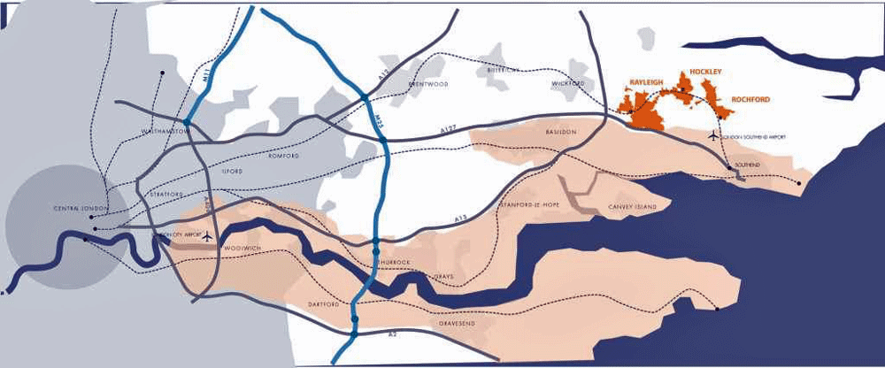
Hockley is located approximately five miles to the north west of Southend-on-Sea, on a peninsula bound by the River Thames to the south, the River Crouch to the north and the North Sea to the east. This gives the settlement a unique landscape setting. This is further enhanced by the ancient Hockley Woods immediately to its south, which forms part of the Upper Roach Valley special and historic landscape areas. Hockley is also surrounded by Metropolitan Green Belt, which has helped to conserve the area’s rural feel.
Within Rochford District, Hockley sits between the larger town centres of Rochford, to the south east, and Rayleigh to the south west. It is located on the Great Eastern rail connection between Southend-on-Sea and London Liverpool Street, which supports commuting into London.
Hockley is located centrally between Rochford and Rayleigh, and is connected to both by the B1013. The strategic road network is a few minute’s drive away, west of Rayleigh, where the A127, A13 and A130 meet. Local attractors for car journeys are Southend-on-Sea to the south east, Basildon to the west and Chelmsford to the north-west.
Historical evolution
Hockley has a long history, with evidence of Roman activity at Plumberow Mount, as well as a strong early Saxon presence. The settlement was mentioned in the Domesday Book of 1086. Parts of the current Church of St Peter and St Paul building dates form to the twelfth century, though earlier church buildings are believed to have existed prior to this on the site.
Hockley Spa, established in 1843, represented a high point in the popularity and profile of the settlement, though this was short-lived as visitors to the Spa soon opted to head to coastal resorts instead.
The rail line from Liverpool Street, London, was extended and in1889 began stopping at Hockley on its way to Southend-on-Sea. This had a significant impact on Hockley and stimulated the residential expansion of the town, though Hockley did not experience the scale of expansion seen in some other parts of the country around the same period.
Reproduced from the Ordnance Survey mapping with the permission of the Controller of Her Majesty’s Stationery Office Crown Copyright. Unauthorised reproduction infringes Crown copyright and may lead to prosecution or civil proceedings. This copy is believed to be correct. Nevertheless Rochford District Council can accept no responsibility for any errors or omissions, changes in the details given or for any expense or loss thereby caused.
Rochford District Council Licence No. 100018109
Figure 2.1 Rochford's regional context
Reproduced from the Ordnance Survey mapping with the permission of the Controller of Her Majesty’s Stationery Office Crown Copyright. Unauthorised reproduction infringes Crown copyright and may lead to prosecution or civil proceedings. This copy is believed to be correct. Nevertheless Rochford District Council can accept no responsibility for any errors or omissions, changes in the details given or for any expense or loss thereby caused.
Rochford District Council Licence No. 100018109
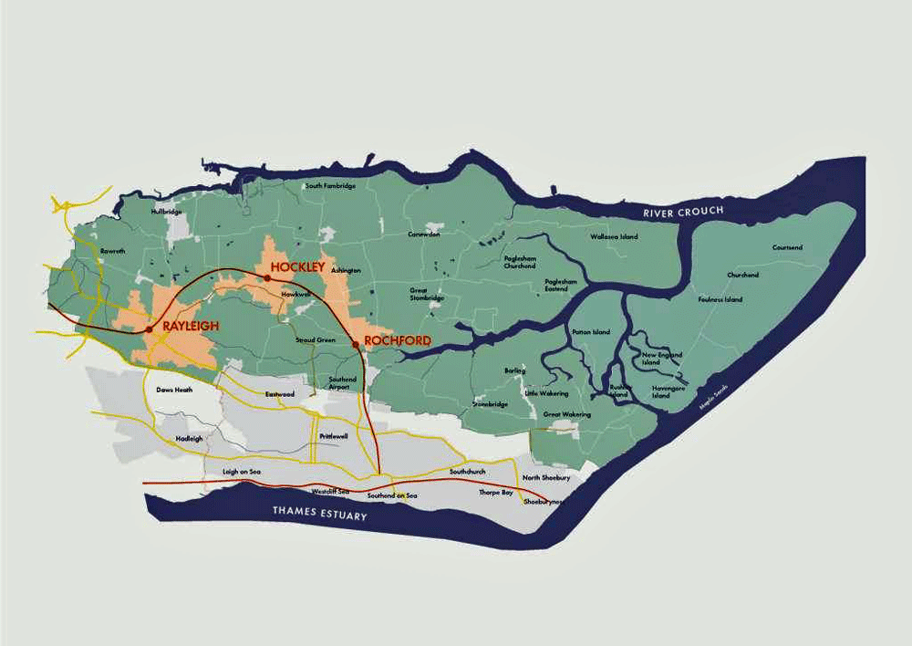
Figure 2.2 Rochford's district context
Reproduced from the Ordnance Survey mapping with the permission of the Controller of Her Majesty’s Stationery Office Crown Copyright. Unauthorised reproduction infringes Crown copyright and may lead to prosecution or civil proceedings. This copy is believed to be correct. Nevertheless Rochford District Council can accept no responsibility for any errors or omissions, changes in the details given or for any expense or loss thereby caused.
Rochford District Council Licence No. 100018109
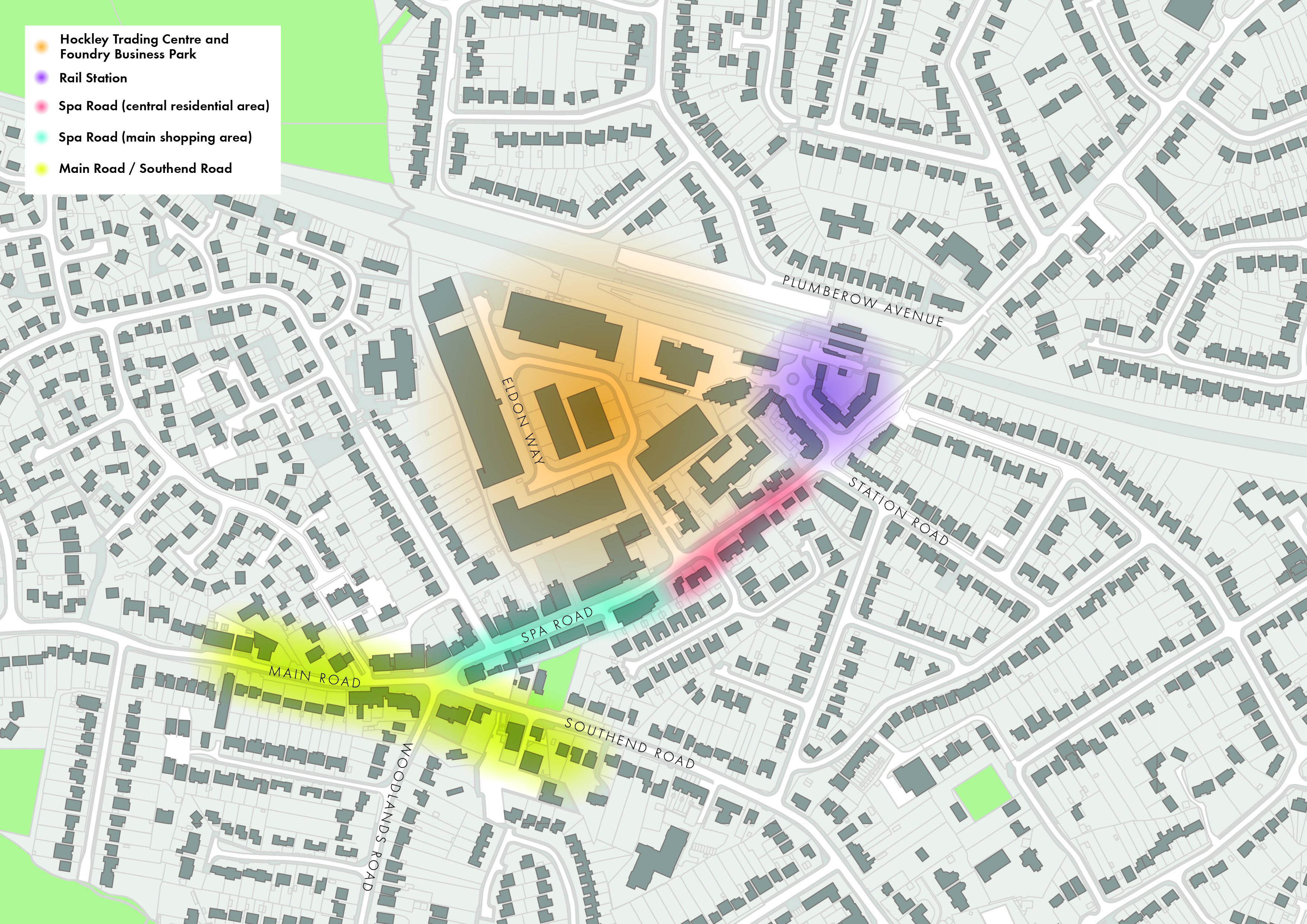
Figure 2.3 Character areas in Hockley
Character areas
The Hockley AAP area has five discernible character areas, each with its own distinctive qualities. The differences between these areas relate to their prevailing patterns of land use, their built form and other factors such as landscaping and the movement network for pedestrians and vehicles.
1) Hockley Trading Centre and Foundry Business Park
This part of Hockley is defined largely by the area’s light industrial uses together with the office and commercial leisure uses that are also present. The buildings here are commercial in character, mainly taking the form of bulky, two to three storey industrial sheds. The public realm and building frontages are dominated by parking and service areas. There is poor connectivity through and within the area, with two access points off Spa Road and no direct link between the two separate industrial estates.
2) Rail station
The station building and line dominate this area. Spa Road, over which the rail line passes, is the principal axis through the town. The public realm in this area is dominated by surface car parking and a roundabout, which also provides access to the Foundry Business Park and is congested at peak times due to pressure resulting from dropping off and picking up rail passengers. The area is well vegetated around Spa Road and there are some areas of open land that provide potential for the reorganisation of car parking arrangements and the road layout. The buildings to the south of the rail line include the station and some recent residential developments. To the north of the rail line there is a row of bungalows.
3) Spa Road (central residential area)
The uses along this part of Spa Road are mainly residential, including some sheltered housing, and it shares the same low-rise, suburban character that dominates Hockley. The varied building line and wide range of building types contribute to an informal urban character in this area. However, a number of the buildings contribute strongly to Hockley’s character and have an intrinsic historic value. In particular, the former Hockley Spa building is a Grade II Listed Building and a local landmark.
4) Spa Road (main shopping area)
Most of the settlement’s retail offer can be found within the shopping parades along this section of Spa Road. The majority of buildings located in this area are single or two storey, though there is a prominent three storey development of shops with maisonettes above. With the exception of one or two buildings, including The Spa public house, the buildings make little positive contribution to Hockley’s character, beyond their important role in anchoring the centre with active commercial uses at ground floor level. Although the footway along this part of Spa Road is relatively wide, a long retaining wall and metal railings act as a significant barrier to pedestrian movement. There is also a concentration of on-street car parking in this area.
5) Main Road / Southend Road
This area is focused around the Spa Road mini-roundabout at the junction of Main, Spa, Southend and Woodlands Roads. These roads are busy due to their role in carrying vehicular traffic from the surrounding area to Southend, Chelmsford and Basildon and this causes congestion at Hockley’s core. With the notable exception of The Spa Public House, the buildings that front this roundabout fail to respond positively to their prominent corner locations and the position of the roundabout as a gateway to Hockley’s main retailing area along Spa Road. The uses in this area are more diverse than elsewhere in the settlement and, as well as shops, include services and community facilities, such as a library, Hockley Parish Council’s offices, places of worship, a dental surgery, a pharmacy, banks, estate agents and solicitors.
(4) 2.3 Policy context
The Hockley AAP has been produced taking into account national, regional and local planning policy, in addition to the various studies that supplement and inform this framework. This is to ensure that the AAP provides a robust policy framework for the future development of Hockley.
National Planning Policy Framework (2012)
The Coalition Government replaced previous national planning policy documents and guidance notes with the National Planning Policy Framework (NPPF) in March 2012. The NPPF was intended to help streamline the planning system and, at its core, has a presumption in favour of sustainable development. This is expanded upon by a number of core planning principles and more detailed policies.
In particular it is noted that the NPPF (Section 2) emphasises the importance of ensuring that local planning policies support the vitality and viability of town centres, and their role at the heart of communities. Practically this means that local planning authorities should promote a diverse retail offer and adopt a town centres first approach, which requires retail, leisure and entertainment, office, and arts, culture and tourism uses to locate in centres ahead of other alternatives.
East of England Plan
Although the Coalition Government has announced that the revocation of Regional Spatial Strategies is imminent, the East of England Planremains part of Rochford District Council’s Development Plan. As such, other planning documents must be in ‘general conformity’ with the Plan, and it continues to provide a policy context for the Hockley AAP.
The Plan allocates a 4,600 new homes target to Rochford District, with a policy steer supporting mixed-use economies in which centres help to attract investment and avoid the need for Green Belt land to be developed, where at all possible.
Rochford Core Strategy (2011)
Rochford District Council adopted a Core Strategy document in December 2011. This document seeks to prioritise new development on brownfield land, with some limited urban extensions to accommodate new housing. In particular, Policy H1seeks the redevelopment of the Hockley Trading Centre and Foundry Business Park, which should also include a mix of employment uses appropriate to the sites’ central location.
The Core Strategy’s approach to centres and retail development is set out in policies RTC1 and RTC2. Respectively, these seek to strengthen and improve the retail offer of the District’s main centres, including Hockley, and direct new retail development and other main town centre uses towards these locations through a sequential, town centres first approach.
The key Core Strategy policy in relation to the AAP is Policy RTC6. This states that Rochford District Council, with partner organisations and landowners, will produce an AAP for Hockley’s centre, to deliver the following:
-
A safe and high quality environment for residents.
-
An enhanced retail offer.
-
The redevelopment of Hockley Trading Centre and Foundry Business Park, and its existing light industrial uses, for a variety of uses more appropriate for a centre location, including retail, residential, commercial, employment and leisure.
-
A public space within a defined centre.
-
Improved connectivity between the retail focus and rail station.
-
Green landscaping along Main Road, Spa road and Southend Road to enhance the visual amenity.
Hockley Area Action Plan Issues and Options Document (2009) & Options Report (2010)
A Hockley AAP Issues and Options document was produced in 2009. This provides a baseline urban design analysis and describes Hockley’s strengths and weaknesses. A number of options for future change in Hockley are considered.
A subsequent Options Report built on the work that had already been undertaken by the earlier 2009 document and presents a revised range of alternatives for improvement. The document proposes a series of general principles to guide land uses, the design of buildings and the public realm, and pedestrian movement, transport and car parking.
In addition, three spatial options that provide different responses to the overarching general principles are presented. Each of these represented a different level of intervention aimed at identifying the particular areas that require either change and investment or protection. The three options were:
1. A series of minimal interventions, with a focus on improving pedestrian links, car parking, the public realm and shop fronts, as well as the replacement of some poor quality buildings with new shops.
2. A programme of higher level interventions, which would involve the replacement of poor quality buildings, including some existing light industrial uses, consolidation and expansion of leisure uses on the Hockley Trading Estate, redevelopment of retail uses on Main Road, and a strong pedestrian link between the rail station and the Hockley Trading Estate.
3. The highest level of interventions, including substantial redevelopment of the Hockley Trading Estate and adjoining buildings fronting Spa Road to create a new leisure and retail space, the relocation of the existing health centre to form a community hub on Southend Road, and new housing north of the rail line.
A number of alternatives for transport are also set out by the Options Report. These centre on proposed junction improvements to alleviate traffic congestion at the Spa Road mini-roundabout and along Spa Road, which could include increasing capacity or creating a shared surface; the provision of improved on-street car parking, in either a parallel or echelon arrangement; and, better drop-off and pick up arrangements at the rail station through the removal of the existing roundabout and its replacement with a straightforward junction and circulation area.
Emerging Allocations (2010) & Development Management documents (2011)
The Council is in the process of preparing its Allocations and Development Management documents. The Allocations document was last published as an issues and options document in February 2010 and the Development Management document was last published as a preferred options document in December 2011.
The Allocations document includes a range of options for Hockley centre and explores various possibilities for retaining, enlarging or shrinking the current centre designation.
The Development Management document includes draft policies that deal with the development of centres. These include policies that seek to control the mix of uses, as well as the conversion of upper floors to residential accommodation.
Hockley Parish Plan (2007)
The Hockley Parish Plan was developed in 2007, following detailed consultation with local residents. The Plan promotes a greening of Hockley’s centre, with more planting and trees and enhancement of the public realm, with shop front improvements and additional seating and lighting.
The plan emphasises the importance of avoiding coalescence between Hockley and neighbouring urban areas by protecting Green Belt land from development. The local community stressed during consultation that they would prefer to see any new development on previously developed land, and would like to limit the overall level of new housing in the area, and ensure that affordable starter homes are provided as a part of any new development.
(7) 2.4 Retail issues
A Retail & Leisure Study for Rochford District was produced in August 2008 to form part of the local planning policy evidence base. This study found Hockley to be the smallest of the District’s three main centres and did not consider it to meet the definition of a town centre as set out in PPS6. It should be noted that PPS6 has since been replaced by the NPPF. Notwithstanding this, Hockley’s centre was considered to benefit from a strong comparison goods sector and a mix of independent shops.
The report highlighted that Hockley retains just 8.1% of its food expenditure, as a result of the limited range of convenience goods on offer within the centre, but is used for top-up food spending. The report also drew attention to the lack of larger retail unit sizes in Hockley to attract national retailers, and the lack of leisure service operators in the centre.
The report identified potential to enhance the frontages in Hockley to create a high quality centre and advised the encouragement of specialist businesses to create a ‘boutique’ retail centre, whilst acknowledging economic challenges presented by this approach. The report also recommended the extension and improvement of the existing retail offer through the development of new, larger scale retail units, and the reclassification of Hockley to District Centre status, which could be reviewed at a later date.
(2) 2.5 Employment issues
An Employment Land Study was produced for Rochford District in September 2008. This considered the current supply and quality of, and future need and demand for, employment space within the District. It forms part of the evidence base for Rochford District Council’s local planning policies.
The report considered the Hockley Trading Centre to be strategically well placed with adequate vehicular access, very good public transport access and good proximity to the centre. The report recommended that the land use here only change if office space is provided as part of a replacement mixed-use scheme, to ensure that jobs are not lost in the centre of Hockley. The buildings on the Hockley Trading Centre were generally considered to be in good condition. Approximately 25% were identified as being in poor condition, though the exact identity of these buildings was not specified.
(3) 2.6 Land ownership context
Freehold land ownership within the AAP area is relatively fragmented, though it is noted that the Hockley Trading Estate is largely controlled by a single landowner. Even here however, there are a range of occupiers with varied lease terms.
The implication of this is that Rochford District Council may have to assist in land assembly to fully realise the vision set out within the AAP. In the shorter-term there may also be the complication of occupiers having to be relocated to other premises whilst development takes place.
(3) 2.7 Property market overview
Despite general market uncertainty since the 2007 “credit crunch”, more recently there have been some encouraging signs, especially in London and the South-east, where developers and investors are beginning to re-enter the market place. Progress does, however, remain slow in the context of limited growth and continued restricted bank lending, and investment is currently being focussed on lower-risk locations.
The headline findings from a comprehensive review of Hockley’s property market were that:
-
The Eldon Way Opportunity Site offers a good opportunity for residential development.
-
There is little demand for flats, but that residential schemes comprising predominately family housing are likely to be viable.
-
Office development would only be viable with a cross-subsidy from higher value uses or public sector funding.
-
Demand to locate in the centre from national multiple retailers, including those in the food and beverage sector, is very weak.
-
There is steady demand from independent retailers for accommodation within the centre.
-
There may be demand from operators for a food store of between 2,000 and 3,000m² (net) within the centre. If the market were unconstrained by land availability and planning policy, then there is a possibility that there might be demand for a larger store.
-
Hockley centre’s catchment is too small to attract development interest from most key leisure sectors, such as cinemas.
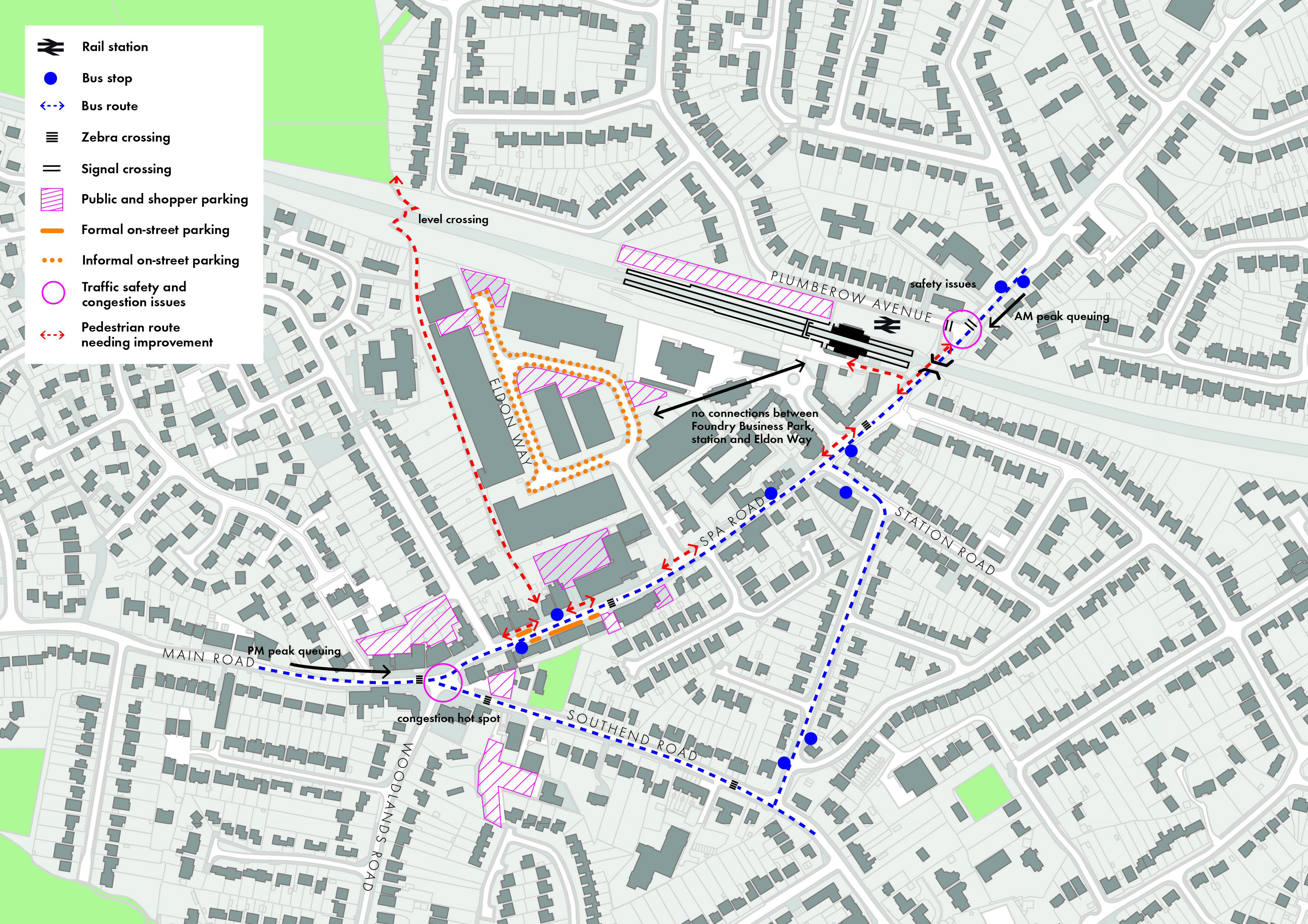
(4) 2.8 Movement issues
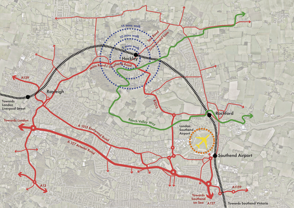
Hockley centre is located largely along Spa Road, between the junction with the B1013 (Main Road / Southend Road) and the rail line. The centre is relatively well-served by public transport, with the rail station giving access to regular services terminating at either Southend Victoria or London Liverpool Street, and with four regular bus services stopping along Spa Road and the B1013. However, there is potential for improvements, including the provision of more frequent services, real-time bus information, shelters at some stops, and improved walking routes between the rail station, bus stops and key destinations.
The B1013 acts as the principal vehicular route through the district, particularly for commuters from the area travelling to and from Southend, Chelmsford and Basildon, as well as forming a strategic route between Rochford and Rayleigh. Congestion in the village centre is a particular concern of local residents, and is focused on the busy Spa Road mini-roundabout, which experiences queuing back towards Rayleigh in the evening peak hours, possibly due to a high proportion of right-turning traffic from Southend Road into Spa Road. Further north along Spa Road, the signalised junction with Plumberow Avenue has been flagged as having some safety issues due to poor sightlines around the adjacent rail underpass.
Hockley centre has a fair amount of parking available to the public. However, much of this is scattered in private back-of-property lots along Spa Road. These appear to be well-used, but there is anecdotal evidence that cars circulating to find spaces here cause some of the congestion in the centre. The main public car park is south of Southend Road, behind the library. It is a pay and display facility, but is not ideally located for short shopping trips. Formal on-street parking in the centre is concentrated along the south side of Spa Road. It is free, but limited to short stays of 1 hour (or 3 hours for disabled bays). There is a large amount of free off-street and informal on-street parking space available in Eldon Way, which is also well-used and is likely to be a preference for many longer-stay visitors. Commuter parking at the rail station is also well-used. It is a pay and display facility, run by NCP.
There is limited provision of cycling facilities, apart from at the station. The lack of permeability across the settlement, due to the railway lines and a number of cul-de-sac streets, forces cyclists onto busy traffic routes and does not help to encourage cycling for short journeys.
Pedestrian facilities, whilst not in a poor state, could certainly be improved. In particular, enhanced crossing facilities could be provided along Spa Road at the roundabout, at the entrance to Eldon Way and at Station Approach. There could be some street clutter and guardrail removal along Spa Road at key locations, and secondary walking routes could be improved or new links created across the centre to improve permeability.
Reproduced from the Ordnance Survey mapping with the permission of the Controller of Her Majesty’s Stationery Office Crown Copyright. Unauthorised reproduction infringes Crown copyright and may lead to prosecution or civil proceedings. This copy is believed to be correct. Nevertheless Rochford District Council can accept no responsibility for any errors or omissions, changes in the details given or for any expense or loss thereby caused.
Rochford District Council Licence No. 100018109
Figure 2.4 Movement context
Reproduced from the Ordnance Survey mapping with the permission of the Controller of Her Majesty’s Stationery Office Crown Copyright. Unauthorised reproduction infringes Crown copyright and may lead to prosecution or civil proceedings. This copy is believed to be correct. Nevertheless Rochford District Council can accept no responsibility for any errors or omissions, changes in the details given or for any expense or loss thereby caused.
Rochford District Council Licence No. 100018109
Figure 2.5 Movement issues
(5) 2.9 The Sustainability Appraisal
The Hockley AAP has been subject to the Sustainability Appraisal process, as required by the European SEA Directive. A report was published in August 2012 documenting this process and assessing the alternatives set out within the 2010 Options Report in relation to their impact on the environmental, social and economic strands of sustainability. A scoping report was prepared prior to this, in July 2012.
The August 2012 report acknowledges that a ‘do nothing’ option is not appropriate, given the regeneration aims of Core Strategy Policy RTC6 and the need to ensure positive outcomes through the creation of a sustainable community with good access to housing and jobs. Of the three spatial alternatives proposed in the Options Report, it was found that all would have a number of positive impacts. However, the medium and higher levels of intervention were considered preferable from a regeneration and economy perspective, provided that phasing and other mitigation measures could be built-in to minimise disruption through noise and traffic congestion during the construction of new any developments.
The transport and movement options are also considered and it is recommended that further traffic modelling is carried out to assess the impact of making changes to the roundabout at the junction of Main, Spa, Southend and Woodlands Roads. In relation to the potential of increased on-street car parking, it is advised that negative effects on the environmental and social aspects of sustainability could be off-set through good design and landscaping, and simultaneous investment in facilities for pedestrians and cyclists.
The outputs of the Sustainability Appraisal have helped to shape the policy options selected. The Council will continue to assess the AAP through the Sustainability Appraisal process and will document this process.