London Southend Airport and Environs Joint Area Action Plan Submission Document
(30) 3. Development Proposals for the JAAP
Introduction
This chapter provides an overview of the policy approach to the development of the airport and the new employment land within the JAAP area. A detailed commentary that supports and provides the context for development is provided with each policy in the next chapter.
1 – The future development and role of London Southend Airport
The Airport Masterplan 2005, prepared by London Southend Airport, sets out a vision for how the airport could grow into a regional airport based on using its current runway (length 1,610 metres), but with the provision of new passenger infrastructure, including a new railway station and passenger terminal facilities. The railway is fundamental to increasing the attractiveness of the airport to potential airline operators as it increases the size of the passenger catchment to include core markets within London (by reducing the travel time to the airport). With this investment, the Airport Masterplan concluded that there is the potential to increase passenger movements at the airport to around 1 million passengers by 2012 and up to 2 million passengers by 2030.
An increase in the operational length of the runway to 1,799 metres, after planning permission was given, has had an important impact in terms of the capacity potential of the airport and its resultant attractiveness to airline operators, notably easyJet. Lengthening the runway across Eastwoodbury Lane enables aircraft with a seating capacity of 100-150 to be operated fully laden out of the airport for business and leisure passenger uses, making the airport a more attractive fixed base for a wider range of operators.
Lengthening the runway is not simply about allowing larger aircraft to use the airport. The modern generation of medium sized passenger aeroplanes3 that may be accommodated as a result of the runway extension are quieter and more fuel efficient – the end result is that the environmental impact of enabling the operation and efficient use of larger aircraft is lessened on the surrounding area.
It is expected that, the extension to the runway will allow the airport to grow faster to a maximum capped passenger capacity of two million passengers per annum (mppa). Evidence suggests that the likelihood of reaching the passenger forecasts is strong, which in turn improves the potential for investment in the other assets such as the extended passenger terminal, and supporting facilities such as a new hotel. In economic terms, it is considered that the airport will act as a driver for the local economy, providing direct employment as well as enhanced opportunities for wider aviation related and business employment.
The expansion of the airport will also include new opportunities for directly related maintenance and overhaul businesses to develop on the extension to the northern MRO area.
2 – The future of the JAAP as an employment area
It is considered that high scale employment growth within the area will make a significant contribution towards delivering new employment opportunities for both JAAP authorities. The JAAP area must take a pro-active role in encouraging employment development for both aviation-related growth (associated with airport growth) and targeting the delivery of accommodation for high-tech industries and offices (specifically in planning use classes B1 and B2). Given the current constraints of the local property market, this will provide the area with the greatest chance of creating employment capacity and attracting investor demand. The market analysis4, while accepting the current market limitations resulting from the credit crunch and recession, recognises that the area will be attractive to companies and investors over the long-term and that new development within the JAAP will be a key economic driver for the area and will help to provide an exceptional offer that is currently lacking in south-east Essex.
A high growth approach will require sufficient employment land to be allocated to allow for the potential of the area to be fully realised. The plan allocates land to accommodate up to 109,000 square metres of additional floorspace, with 99,000 square metres to be located in the new Saxon Business Park and the balance on a smaller business park at Nestuda Way, which together will accommodate up to 5,450 additional jobs in the area over the planning period to 2027. It is also anticipated that 15,000 square metres will become available for redevelopment within the existing Aviation Way Industrial Estate. All together these sites will deliver 6,200 additional jobs (excluding direct airport related employment).
3 – Balancing development with environmental enhancement
More activity from the airport and the allocation of new business parks will inevitably result in some environmental impacts that must be managed considerately and appropriately, and the plan includes a mix of physical measures and a policy approach which, when combined, will help manage and maintain a sustainable future for the area. It is accepted that the environmental impacts (noise and air quality, in particular) will need to be carefully monitored as a result of the increased number of aircraft and vehicle movements in the area.
To address these concerns the plan’s policies and proposals consider the location for new development in combination with opportunities for new public open space to enhance the environment, as well as proposing detailed controls on the operation of the airport to ensure quality of life is maintained for residents. In addition sustainable transport measures will be implemented to minimise traffic impacts and congestion. Furthermore, the JAAP has been subject to independent Sustainability Appraisal and Habitats Regulation Assessment to ensure that environmental and social issues are considered and addressed, where necessary.
4 – Transport and movement
The approach to transport is intended to ensure that development within the JAAP is sustainable, and that there is integration with, and appropriate financial support for, proposals to improve the functioning of both the local and wider highway network (including improvements in Rochford District and the A127 junctions at The Bell, Tesco and Kent Elms Corner) as well as provide internal solutions to movement and accessibility. The transport requirements for the JAAP have taken the following issues into account:
- The need for further capacity on the highway network as traffic flows increase, to ensure congestion will not grow further and limit the ability for economic growth;
- Environmental constraints in terms of highway improvements due to availability of land and property boundaries;
- The principal, signed route for highway access will be via the A127/B1013 to ensure that new trips in and out of Southend and Rochford do not impact significantly on the local highway network, which has limited capacity for improvement;
- The options for transport improvements within the JAAP area and on the local and wider networks, including the provision of new routes, junction improvements and key points of access to new development areas;
- The location of new development within the JAAP area, in relation to the existing and proposed transport links should be considered early in the masterplanning stage to optimise accessibility; and
- The need for a major effort to be focussed on managing traffic growth and encouraging greater use of alternative sustainable transport modes to reduce predicted levels of car borne traffic through traffic management and demand solutions and provision of appropriate infrastructure.
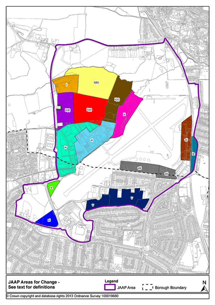
5 – Areas for Change
The development proposals for each part of the JAAP are summarised below and illustrated in the accompanying diagram. These proposals are set out in detail in the next chapter of the plan and on the Proposals Map.
-
Area i - "The Brickwork" site – this area contains a row of residential properties in front of the now cleared works site. The quality of the area is poor. This area has long been identified as an area in need of improvement.
Proposal - The site is located close to one proposed option for new access to Saxon Business Park from Cherry Orchard Way as set out in Policy E3. The allocation is Class B1. There are no plans to remove the residential properties to facilitate development. The area is shown as 1A on the Proposals Map.
-
Area ii(a) - Land to the north of Aviation Way Business Park – this area consists primarily of agricultural land. The proximity of this area to existing development and the airport means that, of current Green Belt land, this area is the most suitable to accommodate an extension to employment activity.
Proposal - Shown as 1B on the Proposals Map, this land is allocated for Class B1 development as set out in Policy E3.
-
Area ii(b) - Land to the east of the Brickworks’ site – this area consists primarily of agricultural land.
Proposal – The site is allocated for leisure uses and open space, with the Westcliff Rugby Club being relocated here with provision of a facility to at least its current standard as shown on the Proposals Map and set out in Policy ENV2. The land remains in the Green Belt.
-
Area ii(c) – Land to the west of the airport – this area consists of agricultural land and includes an area of high biodiversity.
Proposal – The land is set aside as a public open space to link to area ii(b) and to provide a green lung for surrounding development as shown on the Proposals Map and set out in Policy ENV2. The land remains in the Green Belt.
-
Area ii(d) – Green Belt land to the south of the Brickworks’ site – this land is currently set out as playing pitches.
Proposal – This land, shown as Area 2 on the Proposals Map, is allocated for Class B1 development as set out in Policy E3.
-
Area iii - Land adjacent to the airport boundary at the end of Aviation Way – this area is a naturally defined site where potential expansion of the airport boundary might be appropriate.
Proposal – This land will be incorporated into a northside extension of the Maintenance, Repair and Overhaul land within the airport boundary as shown on the Proposals Map and set out in Policy MRO2.
-
Area iv - Aviation Way Industrial Estate – this existing business park has been identified for change because its current use is inefficient as an employment area, it has a poor environment visually and it holds further potential that could be realised. It is intended that the tennis courts at the northern end of the estate will remain in situ and do not form part of the JAAP area.
Proposal – The aim is to see the existing industrial estate significantly improved in terms of the quality of its public realm and to promote, through policy, opportunities for redevelopment, which will contribute to additional jobs in the JAAP area, as set out in Policy E2.
-
Area v - Agricultural / amenity area to the south of the airport boundary – this area lies between two residential areas and currently includes a cricket pitch, agricultural land and private allotments. The area is of low amenity value and improvement to the area could enhance the overall character of the JAAP.
Proposal – This area of land is to be utilised to create a new public open space to provide amenity for neighbouring residents as set out in Policy ENV3.
-
Area vi - Northern maintenance zone within the airport boundary – an operational airport area, this zone contains a number of opportunity sites identified in the Airport Masterplan.
Proposal – This area will provide opportunities for enhancement of the airport’s MRO offer as set out in Policy MRO1. Part of the area to the north is identified separately to provide for the extension of MRO activities as set out in Policy MRO2.
-
Area vii - The Flying Club strip – this area is underused in land terms, holding a small number of flying clubs. Airport proposals see this area becoming the passenger focus for the airport, located around the new railway station and terminal building.
Proposal - Planning consent was granted for the provision of a new passenger terminal and railway station (both completed) and this area is identified on the proposals map (terminal operations hub) for that purpose, recognising there is likely to be a requirement for expansion of the terminal building and the provision of more car parking facilities, as set out in Policy TF1.
-
Area viii - Southern maintenance zone and passenger terminal area – improvements to the airport will lead to opportunity sites within this area to accommodate aviation-related activity.
Proposal - This area is identified on the Proposals Map as the Southern MRO and Airport Development Zone as per Policies MRO3 and ADZ1.
-
Area ix - Land east of the railway line – this thin strip of land abuts the railway and Southend Road.
Proposal - This strip of land is to be retained within the Metropolitan Green Belt to provide a green buffer between the airport and the residential properties to the east, as shown on the Proposals Map and set out in Policy ENV6.
-
Area x - Airport RESA – this area is south of the runway and is the safety zone required for airport operation.
Proposal - This area of land accommodates the extension to the existing runway, and the new link road between Nestuda Way and Eastwoodbury Lane. The new link road has been constructed so as to avoid the safety zone associated with the extended runway. See Policies T1 and LS5.
-
Area xi - Land south-west of Nestuda Way – the area currently contains football pitches and facilities and agricultural land. While parts of the site are restricted in terms of development, and there are no proposals related to the football facilities, the area does have the potential to provide some additional employment land.
Proposal –An area of land to the south of the public safety zone is allocated for B1 development, as shown on the Proposals Map and set out in Policy E8 (Nestuda Business Park).
3 Embraer 195, Airbus A319 4 Rochford and Southend Employment Land Review 2009