Allocations DPD Discussion and Consultation Document
(4)4. Environment
Rochford District covers an area of 65 square miles, or 16, 835 Hectares. Of this area, 12, 763 hectares are designated as Metropolitan Green Belt, which equates to 76% of the District.
In order to meet the housing requirements some Green Belt release will be required, although this will be kept to a minimum. Rochford District Council will endeavour to ensure that the District’s landscape, historic character, agricultural land, undeveloped coast and other natural resources are not adversely affected.
(1)Local Wildlife Sites
Local Wildlife Sites are areas that are not designated under national or international statutory protection, but are considered to be of significant wildlife value. In Rochford there are 39 areas that have been identified as being suitable for designation as Local Wildlife Sites (LoWSs). These are mostly woodland but also comprise areas of Grassland, Mosaic, Coastal and Freshwater habitats. The largest of the LoWS is Rouncefall and Magnolia Fields, which is a 24.35 Ha of Mosaic habitat. Other significant LoWSs include Grove Woods (16.62Ha) and Creeksea Road (18.71 Ha) Mosaic site.
The location of LoWSs as identified by the Local Wildlife Sites Review 2007 is shown on the following map (Figure 4.1):
Figure 4.1 Map showing Local Wildlife Sites identified in the Local Wildlife Sites Review 2007

Sites of Special Scientific Interest (SSSI)
Sites of Special Scientific Interest are designated by Natural England, using a set of specific criteria. The role of a Site of Special Scientific Interest is to uphold, for present and future generations, the diversity and geographic range of habitats, ecosystems, and species throughout England. In England there are more than 4000 SSSIs, accounting for approximately 7% of the country’s land area. Over half of these sites are also internationally important and as such are designated as Special Areas of Conservation (SAC), Special Protection Area (SPA), or Ramsar sites.
Within Rochford District there are three SSSIs:
- Hockley Woods SSSI – area predominantly owned by Rochford District Council. As ancient woodland, the site is of national importance.
- Foulness SSSI – area comprises extensive sand-silt flats, saltmarsh, beaches, grazing marshes, rough grass and scrubland extending over the areas of Maplin Sands, part of Foulness Island, and adjacent creeks, marshes and islands. This site is also of national and international importance.
- Crouch and Roach Estuaries SSSI – covers a complex group of sites including Brandy Hole, Lion Creek, Paglesham Pool, Bridgemarsh Island and marshes near Upper Raypits. The sites include salt marsh, intertidal mud, grazing marsh, and a fresh water reservoir.
(2)Special Protection Areas
Special Protection Areas or SPAs are strictly protected sites classified for rare or vulnerable birds and regularly occurring migratory species. They are designated in accordance with Article 4 of the EC Directive on the conservation of wild birds (79/409/EEC).
There are 2 sites within Rochford District that have been designated as SPAs; Foulness (classified in 1996) and the Crouch and Roach Estuaries (classified in 1998).
(1)Special Areas of Conservation
Special Areas of Conservation, or SACs, have been designated under the EC Habitats Directive and as such are strictly protected. The habitat types and species that fall under this designation are those that are considered to be most in need of conservation at a European level (excluding birds).
The whole of the Foulness and Crouch and Roach Estuaries falls under the SPA covering the Essex Estuaries. This relates to the seaward part of the coastal zone.
Ramsar Sites
Ramsar sites are wetlands of international importance, that have been designated under the Ramsar Convention.
There are 2 listed Ramsar Sites in Rochford; namely Foulness and the Crouch and Roach Estuaries.
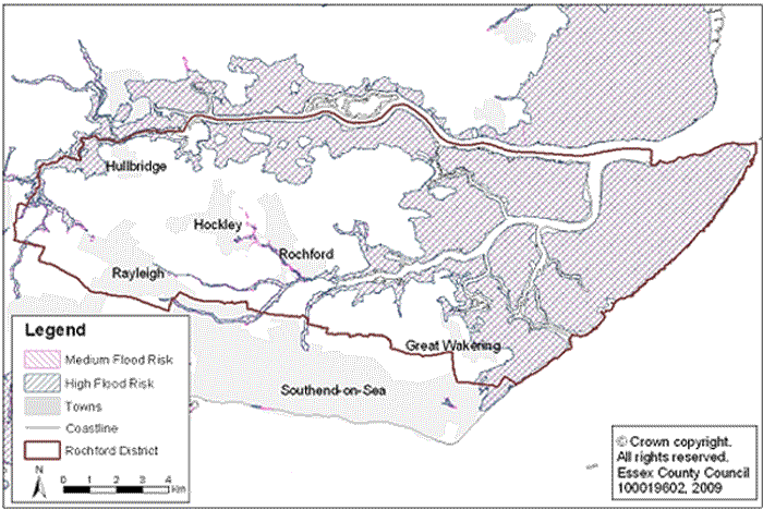
(3)Flood Zones
As the northern, eastern and south eastern parts of the District are on the Crouch and Roach Estuaries, areas around this may be liable to flooding, erosion and land instability. Figure 4.2 below shows the extent of land within the District that falls within Flood Zone 2 (medium risk) and Flood Zone 3 (a and b) (high risk).
Figure 4.2 Areas at risk of flooding
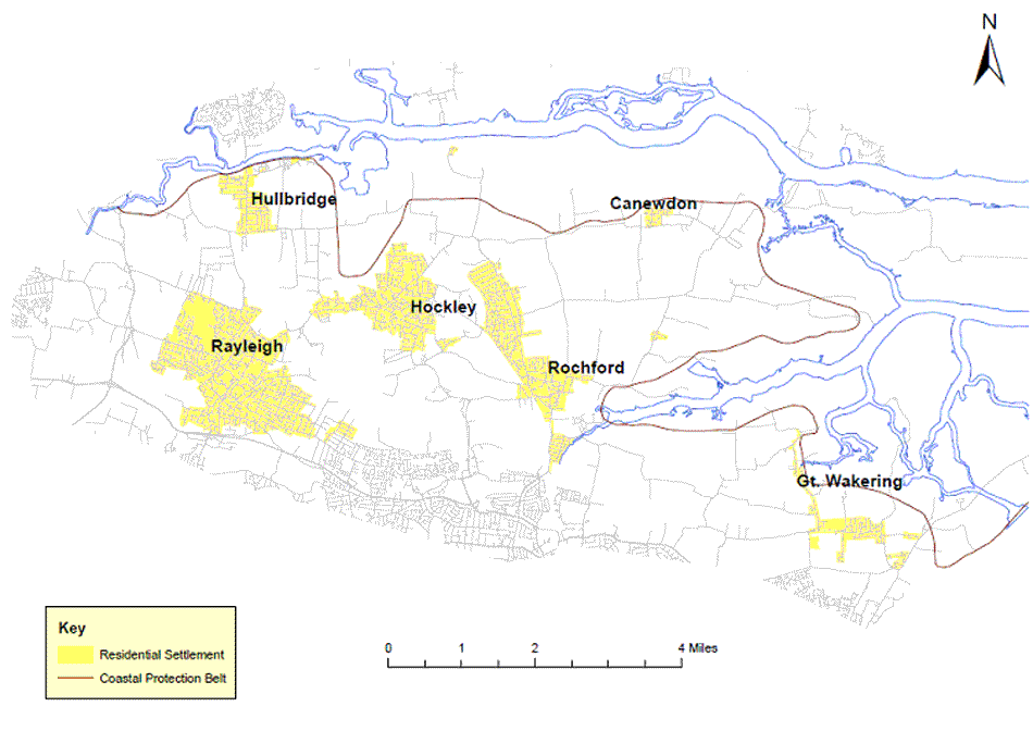
Coastal Protection Belt
Rochford District Council has long encouraged policies that restrict development along the coast and estuaries in order to protect the irreplaceable natural resource. PPG20 (Coastal Planning) provides guidance to local authorities on planning for development and protecting the coastal environment. It is particularly clear on the necessity of protecting the coastal environment.
The Coastal Protection Plan, adopted in 1984, defined the extent of the coastal areas within Essex where there would be the most stringent restriction on development, and this is supported by the Rochford District Council Core Strategy.
(1)Upper Roach Valley
The Upper Roach Valley is a large “green lung” bounded by Rayleigh, Hockley, Rochford and Southend, and was designated in the Rochford District Replacement Local Plan (2006) as a Special Landscape Area and as an Area of Ancient Landscape. Seven of the fourteen ancient woodlands found in the District lie within the Upper Roach Valley, and there are also a number of Local Wildlife Sites found within its boundaries. The emerging Core Strategy supports the Upper Roach Valley as a vast green lung and as an area providing informal recreation opportunities for local residents.
(2)Environmental Allocations
As previously noted, Rochford District covers an area of 65 square miles, or 16, 835 Hectares. Of this area, 12, 763 hectares are designated as Metropolitan Green Belt, which equates to 76% of the District.
Some of this Green Belt will need to be reallocated in order to meet the housing and employment requirements set out for the District in the East of England Plan (2008). The amount that will be released will be kept to a minimum and appropriate, available brownfield sites will be exhausted before Green Belt release is considered.
Rochford District Council will endeavour to ensure that the District’s; landscape, historic character, agricultural land, undeveloped coast and other natural resources are not adversely affected.
(1)Local Wildlife Sites
Local Wildlife Sites (LoWSs) are areas of land with significant wildlife value. They were previously known as Sites of Importance for Nature Conservation (SINCs) and County Wildlife Sites (CWSs). Alongside statutory protected areas, LoWSs represent the minimum habitat we need to protect in order to maintain the current wildlife levels in Essex.
The areas designated as Local Wildlife Sites in the Replacement Local Plan (2006) were assessed in the Local Wildlife Site Review 2007 against current Local Wildlife Site Selection Criteria to determine whether a Local Wildlife Site designation could be given. The results of this assessment are detailed within the Local Wildlife Site Review 2007.
The Local Wildlife Site Review 2007 identified 39 areas that merited designation as LoWSs. The location of these sites is demonstrated on the following map (Figure 4.3):
Figure 4.3 Map showing proposed areas to be allocated as Local Wildlife Sites

Table 4.1 below details the sites illustrated in Figure 4.3. These sites are proposed to be allocated as Local Wildlife Sites.
Table 4.1 List of sites proposed to be allocated as Local Wildlife Sites
| Code | Site Name | Area (ha) | Grid Ref |
|---|---|---|---|
|
R1 |
Kingley Wood |
1.7 |
TQ794900 |
|
R2 |
Hullbridge Road Meadow |
0.6 |
TQ806937 |
|
R3 |
Blounts Wood |
3.7 |
TQ818928 |
|
R4 |
Hockley Woods Complex |
14.9 |
TQ826918 |
|
R5 |
Grove Woods |
16.6 |
TQ827902 |
|
R6 |
Rawreth Hall Wood |
2.1 |
TQ829905 |
|
R7 |
Brandy Hole Marsh Extension |
14.0 |
TQ830953 |
|
R8 |
Hockleyhall/Crabtree Woods |
14.6 |
TQ832934 |
|
R9 |
Folly Wood |
1.4 |
TQ832926 |
|
R10 |
New England Wood |
4.0 |
TQ833903 |
|
R11 |
Bett’s Wood |
2.9 |
TQ834928 |
|
R12 |
The Dome Grasslands |
5.3 |
TQ835947 |
|
R13 |
Edwards Hall Park |
11.6 |
TQ837896 |
|
R14 |
Marylands Wood |
5.4 |
TQ838930 |
|
R15 |
Plumberow Wood |
5.4 |
TQ839940 |
|
R16 |
Belchamps Camp, Hockley Woods |
1.5 |
TQ841918 |
|
R17 |
Gustedhall Wood |
5.7 |
TQ841907 |
|
R18 |
The Scrubs |
9.6 |
TQ842903 |
|
R19 |
Primrose Wood |
1.3 |
TQ846904 |
|
R20 |
Cottons |
1.0 |
TQ848902 |
|
R21 |
Beckney Wood |
13.2 |
TQ848940 |
|
R22 |
Potash Wood |
13.8 |
TQ849909 |
|
R23 |
Trinity Wood |
3.3 |
TQ856937 |
|
R24 |
Magnolia Nature Reserve and Fields |
29.2 |
TQ860927 |
|
R25 |
Hyde Wood |
2.9 |
TQ877938 |
|
R26 |
Doggetts Pond |
7.0 |
TQ878915 |
|
R27 |
Sutton Ford Bridge Pasture |
2.0 |
TQ882895 |
|
R28 |
River Roach at Rochford |
8.1 |
TQ883903 |
|
R29 |
Wood Sloppy |
2.2 |
TQ885924 |
|
R30 |
Butts Hill Pond |
0.3 |
TQ899947 |
|
R31 |
The Finches |
1.3 |
TQ905944 |
|
R32 |
Lion Creek Meadow |
3.1 |
TQ922947 |
|
R33 |
Canewdon Special Roadside Verge |
0.2 |
TQ923946 to TQ925945 |
|
R34 |
Barling Pits |
10.1 |
TQ935896 |
|
R35 |
Star Lane Pits |
6.9 |
TQ937873 |
|
R36 |
Paglesham Seawall |
12.3 |
TQ945917 |
|
R37 |
Wakering Landfill Site |
24.0 |
TQ953886 |
|
R38 |
Great Wakering Common |
4.5 |
TQ954878 |
|
R39 |
Wallasea Island Managed Realignment |
90.3 |
TQ964946 |
(7)Do you agree that the areas shown in Figure 4.3 and listed in Table 4.1 should be allocated as Local Wildlife Sites?
Upper Roach Valley
The Upper Roach Valley was designated in the Rochford District Replacement Local Plan (2006) as a Special Landscape Area and as an Area of Ancient Landscape. The area is a large “green lung” bounded by Rayleigh, Hockley, Rochford and Southend, and is of importance in terms of informal recreational opportunities, and particularly in terms of its landscape characteristics.
The need for more informal recreational space in South East Essex has been identified on numerous occasions over a number of years, including in the 1982 and 2001 Structure Plans and the 2005 Thames Gateway South Essex Greengrid Strategy.
The Council has sought to help address this need through the establishment of Cherry Orchard Jubilee Country Park. Work began on the Country Park in 2002 and the park has been gradually expanded. The approach to the development of the Country Park is centred on ensuring the right conditions are in place in order for fauna and flora to flourish, and utilising the existing features of the landscape, all with the minimum of human interference.
The emerging Core Strategy proposes that the Upper Roach Valley be protected from development which would undermine the area’s role as a green space providing informal recreational opportunities. It also proposes that the Cherry Orchard Jubilee Country Park be expanded and linked with other parts of the Upper Roach Valley.
The Allocations Development Plan Document should therefore designate the area that is considered to be the Upper Roach Valley for planning purposes. The suggested area to be allocated as the Upper Roach Valley is illustrated in Figure 4.4.
Figure 4.4 The Upper Roach Valley
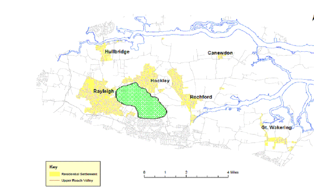
(9)Do you agree that the area shown in Figure 4.4 should be allocated as the Upper Roach Valley?
Coastal Protection Belt
The Coastal Protection Subject Plan outlines the extent of the coastal areas in Essex. The Protection Belt highlights where there should be control of development along the coast due to the fact that it is an irreplaceable natural resource, where much of it is covered by internationally and nationally recognised conservation designations.
Guidance has been provided at national level in PPG20 (Coastal Planning), which indicates that there is a clear need for protection of the undeveloped coast. This is supported by regional policy in the Coastal Protection Subject Plan and the Essex and Southend-on-Sea Replacement Structure Plan (2001).
The emerging Rochford District Council Core Strategy Submission Version also embodies this, and states that the Council will protect and enhance the landscape, wildlife and heritage qualities of the coastline, recognising the implications of climate change and sea rise, whilst not permitting any development in areas that are at risk from flooding erosion and land instability and ensuring that exceptionally permitted development will not have adverse impacts on the open and rural character, historic features and wildlife of the coast.
The Coastal Protection Belt was delineated in the Replacement Local Plan (2006) as shown in Figure 4.5.
Figure 4.5 Map showing boundary of Coastal Protection Belt in Rochford District