Canewdon High Street Conservation Area Appraisal and Management Plan
5. Origins and Development
Location and landscape setting
5.1 Canewdon lies in the north of Rochford District, south of the Crouch estuary. The town of Rochford is approximately four miles to the south west.
5.2 The village occupies a low hill of London Clay topped with river terrace gravels about 30m above sea level, south of the marshes, with the High Street running east-west along the ridge. The hill is one of the highest on the Essex coastline, and from the High Street views open up to the south through gaps in the hedges and down Anchor Lane. The church commands a dominant position on the western edge of the village with wide views across the Crouch estuary. The hilltop location is reflected in the settlement name which has the Saxon meaning 'hill of Cana's people' (Reaney 1935).
5.3 The coastal landscape of the Crouch Estuary has changed considerably over time. Until the post-medieval period the tidal marshes bordering the Crouch estuary came much closer to the village. Between the edge of the London Clay on which the village now sits and the river was a broad sweep of coastal marsh which would have been bisected by numerous small creeks and tidal channels. Much of it may have been submerged with each high tide. Piecemeal embankment and drainage of the marshes took place throughout the medieval and early post-medieval period until final enclosure in 1774. The coastal marshes are under renewed threat from rising sea-levels (Medlycott 2003).
5.4 The surrounding landscape is predominantly composed of arable fields. Loss of hedgerows has eroded the historic field pattern in places, resulting in large prairie fields particularly to the north of Canewdon. However a rectilinear pattern of fields can still be made out running in a north-south direction along the axis of the main roads through the village representing a more historic field structure, perhaps pre-medieval in date.2.
5.5 The village stands on a quiet country road leading from Hullbridge eastwards to the reclaimed land between the Crouch and the Roach estuaries, terminating at Wallasea Island.
5.6 The area around the residential development of the village is designated Green Belt. The village is bounded to the west and north by Coastal Protection Belt.
5.7 The village green which forms part of Canewdon model village, built in the 1960s, lies outside the conservation area but creates a broad open space at the west end of the village. It is designated in the Local Plan as public open space.
Historical development 3
5.8 Despite a lack of formal archaeological excavations a range of sites and deposits are known at Canewdon reflecting multi-period occupation from at least the Neolithic (4,000-2,000 BC). The elevated position of the site made it an attractive choice for early settlers, and its proximity to the coast was valuable for sea trading and salt production. Prehistoric and Roman settlement in the area comprised farmsteads and cemeteries on the higher ground, and salterns and other coastal sites fringing the edges of the marshes. Gravel extraction in the early 18th century to the north of the church revealed a cremation cemetery of unknown date. In the first half of the 20th century gravel extraction revealed an important range of prehistoric remains including a Neolithic axe hoard and Iron Age burials. One of the most significant finds from the area is the Bronze Age Canewdon paddle, now in the National Maritime Museum, Greenwich, which demonstrates the close links with the coastal environment. The area to the north of the present settlement is characterised by a line of Iron Age or Roman Red Hills (salt production sites) marking the edge of the coastal marsh at that date.
5.9 The earliest documentary reference to Canewdon is in the Domesday Book of 1086, although the place name itself indicates earlier Saxon origins (Reaney, 1935). The area between Canewdon and Ashingdon is widely believed to have been the site of the important battle of Assandune between the Saxons under Edmund Ironside and the armies of the Danish King Canute. Canewdon is identified in local folklore as the site of King Canute's camp, and Canewdon church is a possible candidate for the site of the minster built by Canute in 1020 to commemorate the war-dead. However the location of both the battle site and the minster are matters of academic dispute.
5.10 The Domesday Book records Canewdon at the very end of the Saxon period in 1066 and 1986. The lands belonged to Swein of Essex, the principal land-holder of the Rochford area, who would have had a hall there. Although the location of the hall is not proven, Canewdon Hall which lay to the north of the church in the area now occupied by Canewdon Hall Close is the most logical site. The parish church of St Nicholas is known to have been in existence in 1100 and it is probable that a church existed on the site prior to the Norman Conquest. The location of the late Saxon settlement is unproven, but comparison with other sites would suggest that a number of households would have been clustered close to the church and hall. The remainder would have been scattered throughout the parish in individual farms and cottages.
5.11 By the beginning of the medieval period the area was divided into five manorial holdings, Canewdon Hall, Pudsey Hall, Apton Hall, Scotts Hall and Lambourne Hall. The principal manor of Canewdon comprised 26 households in 1086, whilst the four smaller manors had 19 households between them.
5.12 A degree of nucleation took place in the later medieval and post-medieval period with the development of the village along the High Street to the east of the church and hall, as well as more dispersed settlement around the four smaller manorial halls and scattered isolated farms and cottages. The extent and location of the later medieval village settlement can be assessed from the 1777 Essex map of Chapman and André, which shows the church/hall complex and a line of dwellings along the southern edge of the High Street (Fig. 3). The settlement pattern now encompassed by the two Canewdon conservation areas reflects this arrangement.
Fig.3 Chapman and André map, 1777. The windmill stood until the late 19th century on the site now occupied by the Model Village.
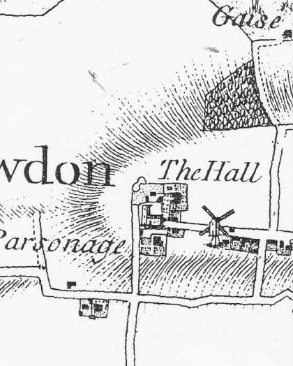
Fig.4 Tithe map of Canewdon, 1840, showing further development mainly on the south side of the High Street and the rectilinear arrangement of fields in the surrounding landscape.
5.13 In the late 18th century the village saw a number of new developments that reflected the growing organisation of community life. In 1785 Pond House (no longer extant) adjacent to the village pond was identified for conversion into a parish workhouse. The workhouse closed about 50 years later when the Rochford Union workhouse was constructed. The buildings now known as Rest Cottages were erected as a children's workhouse also in 1785. The village lock-up was erected around 1775 near the pond for the imprisonment of felons by the parish constable. This small weatherboarded building is now located at the east gate of the churchyard. A school and schoolmaster's house was built at the west end of the High Street in 1799 on Poors' Land. This is now a private residence known as Vicarage Cottage. As the population grew the school became inadequate and a new school was built in the High Street in 1863, a red brick building with a slate roof. This building still stands as part of the now much expanded school complex. In 1803/4 a well was dug on the orders of the Parish Vestry, housed in a small timber-shed on the south side of the High Street. This had disappeared by 1970 and now lies beneath the driveway by Richland House. In 1833 a congregational chapel was built to the east of the village, but was demolished during the Second World War and later re-sited on the High Street as it stood in the line of fire of guns protecting the radar site.
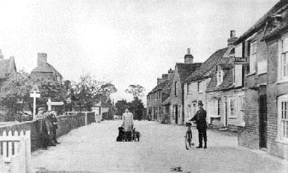
Fig. 5 Canewdon High Street in the early 20th century. The distinctive roofline of The Algiers is visible in the left background, with the gable of Canute House just visible slightly set back from this. The Anchor pub is in the right foreground. The buildings beyond this on the right have now gone, and the area is occupied by Costcutters, the school car park and late 20th century houses.
5.14 In 1801 the population was 569, rising to 723 in 1841, and declining once more to 495 in 1901. By the late 19th century the High Street was developed on both the north and south sides, but the south side remained the most densely built up with closely packed small plots built up to the street edge, whilst the north side remained more open. The Post Office Directory of 1871 lists commercial premises within the parish, including a shoemaker, a cooper, a carpenter, two bakers, a miller, a harness-maker and a blacksmith, and most of these are likely to have had premises in the village itself. Writing in 1867, the local historian Philip Benton recorded that the area had, over the preceding century, witnessed a degree of neglect with some houses unfit for human habitation, and 'few recreations ... except those enjoyments afforded by the public houses'.
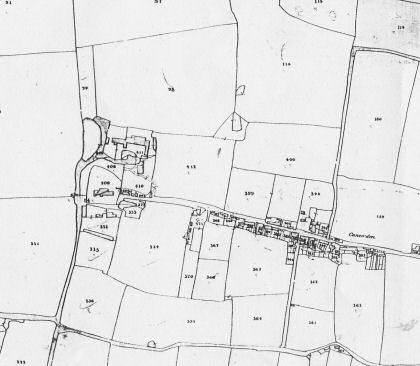
Fig. 6 Canewdon High Street from the 1st edition OS map, 1873, with tightly packed narrow plots built up to the street edge on the south side.

Fig. 7 Canewdon from the 2nd Edition OS map, 1897.

Fig. 8 Canewdon from the 3rd OS map, 1924.

5.15 Canewdon played an important role in national defence during the Second World War when a radar site (Air Ministry Experimental Station Type 1) was located on the east edge of the village, one of the first to be built in Britain. The site comprised both a Receiving and Transmission site with four masts on each, which would once have dominated the skyline. They were used to plot the positions of British and enemy aircraft. Little remains of these important installations today, although the buildings that used to house the transmitting equipment still survive along with a number of pillboxes.
Fig. 9 The High Street c.1981, with the Old Post Office on the right and Russell Row on the left.

5.16 In the post-war period Canewdon expanded with new housing developments around the settlement fringes to the north and south of the High Street, notably the Model Village built in the 1960s to the south west of the village around a large green. Along the High Street modern infill and replacement of older properties occurred, particularly on the south side of the street and around the school, with substantial semi-detached and detached properties reflecting a degree of affluence in the area. Canewdon today offers a wide range of housing and local services including village stores, pubs and a school, and it is a close knit village community. The 2001 census revealed the population of the parish to be 1477 with 558 households.
Fig.10 Date of construction of buildings in the conservation area.

Reproduced by permission of Ordnance Survey® on behalf of the Controller of Her majesty's Stationery Office. ©Crown Copyright. Licence number LA100019602
2 For more information on the landscape character see Landscape Character Assessment of the Essex Coast (Essex County Council/Schéma d'Aménagement Intègre du Littoral 2006)
3 For the history of Canewdon from an archaeological perspective, see Medlycott 2003, and for Canewdon and the wider historic environment of Rochford District see the Rochford District Historic Environment Characterisation Project report of 2005. General village history can be found in publications by Ken Smith.